
Agenda
Council Meeting
28 July 2022


SHIRE OF MANJIMUP – Council Meeting AGENDA
28 July 2022
Notice to all councillors
An Ordinary Meeting of Council is called for Thursday 28 July 2022 commencing at 5:30pm in the Council Chamber.
![]()
________________________
Andrew Campbell
Chief Executive Officer
20 July 2022
DISCLAIMER
The advice and information contained herein is given by and to the Council without liability or responsibility for its accuracy. Before placing any reliance on this advice or information, a written enquiry should be made to the Council giving the entire reasons for seeking the advice or information and how it is proposed to be used.
|
IMPORTANT MATTERS AFFECTING THOSE ATTENDING THE MEETING AND THOSE AFFECTED BY A DECISION OF THE MEETING.
1. Please note this meeting may be electronically recorded.
2. Decisions made in this meeting are unable to be acted upon by the person who has been granted the authorisation unless and until the decision is able to be implemented by the Chief Executive Officer and in any event not before the afternoon of the first business day following this meeting. If you are in any doubt about a decision please contact the Shire prior to making any commitments.
|
SHIRE OF MANJIMUP
Council Meeting Thursday 28 July 2022
To be held
In the Council Chamber
Commencing at 5:30pm
Agenda
1. DECLARATION OF OPENING / ANNOUNCEMENT OF VISITORS:
2. ANNOUNCEMENTS BY THE PRESIDENT:
The Shire of Manjimup respectfully acknowledges the Noongar people as the Traditional Custodians of the lands in which we work throughout the region and we pay our respects to their Elders, past present and emerging.
3. ATTENDANCE:
3.1 Apologies:
3.2 Approved Leave of Absence:
Councillor Robert Taylor has been granted a Leave of Absence for this meeting.
4. DECLARATIONS OF INTEREST:
[Part 5, Division 6 of the Local Government Act 1995 requires that a member must disclose the interest of the member and the nature of the interest in writing before the meeting or immediately before the matter is discussed.]
5. PUBLIC QUESTION TIME:
5.1 Response to public questions taken on notice
5.2 Public Question Time
[Under meeting procedure determined by the Shire of Manjimup Standing Orders Local Law 2013, this is the only opportunity for members of the public to ask up to a maximum of two questions of Council. There is no further opportunity to question the Shire of Manjimup during the meeting. Questions can be asked on any Shire matter, not just on issues included in the meeting agenda and each person shall have up to 3 minutes to ask their questions which may be extended by an additional 3 minutes where considered appropriate by the Presiding Member. Persons asking questions are entitled to a response unless the question is declared “out of order” by the Presiding Member. If a matter requires further investigation, that response may be in writing. Any person asking questions of Council must state their correct name and address as this will form part of the public record of this meeting]
6. PRESENTATIONS:
6.1 Petitions
6.2 Presentations
6.3 Deputations
6.4 Delegates’ reports
6.5 Conference Reports
7. CONFIRMATION OF PREVIOUS MINUTES:
________________ / __________________
That the Minutes of the Ordinary Meeting of the Council held on 7 July 2022 be confirmed.
8. MOTIONS OF WHICH PREVIOUS NOTICE HAS BEEN GIVEN:
9. OFFICERS’ REPORTS:
For the interest of the Gallery, I will explain how we are about to consider the agenda items for this meeting.
All Councillors have had the agenda for one week giving us time to thoroughly review each item.
This meeting is the only time that Councillors are able to formally debate agenda items. Soon I will read out each item listed in the Agenda and any Councillor will be able to identify an agenda item they wish to debate. These items will be listed on the board behind me.
All items not identified by Councillors to be debated will be moved in accordance with the Officers Recommendation in one motion as listed in the agenda and moved en bloc for voting purposes.
If your item is not listed on the board and is moved en bloc it will be passed as per the Officer Recommendation. Following this Council will consider the remaining items in agenda order.
|
MAJORITY |
ITEM |
COUNCIL OFFICERS’ REPORTS |
Page No. |
|
|
|
OFFICE OF CEO |
|
|
|
9.1 |
Office of CEO |
|
|
Absolute |
9.1.1 |
Proposed Adoption of 2022/23 Annual Budget |
7 |
|
|
9.1.2 |
April to June 2022 Quarterly Report - Office of the CEO |
13 |
|
|
|
BUSINESS DIRECTORATE |
|
|
|
9.2 |
Corporate & Governance |
|
|
|
9.2.1 |
Proposed Manjimup Community Garden Licence to Occupy |
15 |
|
|
9.3 |
Finance & Administration |
|
|
|
9.3.1 |
Monthly Financial Activity Statement - May 2022 |
17 |
|
|
9.3.2 |
Council Financial Payments for June 2022 |
20 |
|
|
9.4 |
Information Communications Technology |
|
|
|
|
DEVELOPMENT & REGULATION DIRECTORATE |
|
|
|
9.5 |
Statutory Planning |
|
|
|
9.5.1 |
Proposed Dam with Reduced Setback at Lot 9477 Jones Road, Yanmah |
25 |
|
|
9.5.2 |
Proposed Winery and Cellar Door at Lot 3 (41) Towie Road, Middlesex |
32 |
|
|
9.5.3 |
Proposed Animal Establishment (Dog Breeding) at Lot 1 (33) Vic Road, Middlesex |
39 |
|
|
9.5.4 |
Proposed Plantation at Lot 2375 (405) Kurandra Road, Middlesex |
43 |
|
|
9.5.5 |
Proposed Subdivsion/Amalgamation (boundary adjustment) - Lot 103, 12966, 1660, 1659 & Nelson Location 1181 Dawsons Road, Balbarrup |
50 |
|
|
9.5.6 |
Proposed Dwelling - Single with Retrospective Clearing at Lot 85 Karri Lane, Quinninup |
56 |
|
|
9.5.7 |
Proposed Dwelling - Single and Retrospective Land Clearing at Lot 28 Karri Lane, Quinninup |
64 |
|
|
9.5.8 |
Quarterly Report - April to June 2022 - Director of Development and Regulation |
72 |
|
|
9.5.9 |
Delegated Planning Decisions for June 2022 |
74 |
|
|
9.5.10 |
Proposed Dwelling - No 3 (Lot 160) Merlot Street, Walpole |
77 |
|
Absolute |
9.5.11 |
Proposed Purchase of New Generator - Windy Harbour |
84 |
|
|
9.6 |
Building Services |
|
|
|
9.7 |
Ranger & Emergency Services |
|
|
|
9.7.1 |
Application for the Keeping of More Than Two Dogs at Lot 370 (1) Duffield Street Manjimup |
87 |
|
|
9.7.2 |
Application for the Keeping of More Than Two Dogs at Lot 100 (27B) Collier Street, Manjimup |
92 |
|
|
9.8 |
Environmental Health Services |
|
|
|
|
COMMUNITY SERVICES DIRECTORATE |
|
|
|
9.9 |
Community & Recreation Services |
|
|
|
9.9.1 |
Department of Local Government and Cultural Industries Consultation - Draft Child Safe Awareness Policy for Local Government |
97 |
|
|
9.9.2 |
Quarterly Report April - June 2022 - Community Services Directorate |
102 |
|
|
9.10 |
HACC Services |
|
|
|
9.11 |
Libraries & Cultural Services |
|
|
|
|
WORKS AND SERVICES DIRECTORATE |
|
|
|
9.12 |
Technical Services |
|
|
|
9.12.1 |
Review of Council Policy 9.1.3 Street Lighting Policy, 9.1.4 Guidelines for Sub-Divisional Development Policy, 9.1.5 Road Verge Directional Signs Policy, 9.1.10 Engineering Construction Standards for Planning Applications Policy and 9.1.11 Land Acquisition and Road Boundary Adjustments Policy |
104 |
|
|
9.13 |
Works |
|
|
|
9.13.1 |
Quarterly Report April to June 2022 - Works and Services Direcorate |
108 |
|
|
9.14 |
Parks & Gardens |
|
|
|
9.15 |
Occasional and Management Committees |
|
|
|
9.16 |
Advisory Committees |
|
|
|
9.16.1 |
Unconfirmed Minutes of the Manjimup Rea Park and Collier Street Redevelopment Advisory Committee Meeting held 21 June 2022 |
110 |
|
|
9.16.2 |
Unconfirmed Minutes of the Local Emergency Management Committee (LEMC) Meeting held 13 July 2022 |
112 |
_____________________ / _____________________
“That Council adopt the recommendations contained in the Council Officers and Committee Reports on pages 1 – 113 of the Agenda with the exception of:
12
9.1.1 Proposed Adoption of 2022/23 Annual Budget
|
PROPONENT |
Chief Executive Officer |
|
OWNER |
N/A |
|
LOCATION / ADDRESS: |
Whole Shire |
|
WARD: |
Whole Shire |
|
ZONE: |
Whole Shire |
|
DIRECTORATE: |
Office of CEO |
|
FILE REFERENCE: |
F160187 |
|
LEGISLATION: |
Local Government Act 1995 |
|
AUTHOR: |
Andrew Campbell; Greg Lockwood |
|
DATE OF REPORT: |
13 July 2022 |
|
DECLARATION OF INTEREST: |
Authors are employees of the Shire of Manjimup and own property in the Shire of Manjimup, however this is an Interest In Common. |
Background:
The 2022/23 Annual Budget Document is tabled for Council’s consideration and adoption.
DOCUMENT TABLED
PUBLIC Consultation Undertaken:
Nil
COMMENT (Includes Options):
Council has provided significant input and review of the 2021/22 Annual Budget through the following processes:
· Shire of Manjimup Strategic Community Plan 2021-2031;
· Shire of Manjimup Corporate Business Plan 2022-2026;
· The 2022/23 Annual Budget has been influenced by a need to invest in the renewal of Shire assets; and
· A program of Council information briefing sessions between March and July 2022.
Contained in the front section of the 2022/23 Annual Budget is a “Budget Overview” providing a summary of the main components of the budget including graphical presentation of trends over recent years.
Rate Rise
It is proposed that the average general rate rise across the district is 4.9%. The Valuer General assessed Shire of Manjimup Unimproved Value (UV) properties as at 1 July 2022. This revaluation has seen an overall increase to the UV data base of approximately 10.58%. The Shire of Manjimup’s 2022/23 UV rate in the dollar has been adjusted down to reflect these value changes to give an average 4.9% rates change across the UV data base in 2022/23.
The Valuer General did not undertake a revaluation of Shire of Manjimup Gross Rental Value (GRV) properties as this occurs every 6 years and GRV properties were assessed 1 July 2018. The only variations to GRV valuations will be due to individual development on properties or some form of significant change that would affect the overall valuation.
Council Rating Policy
A special rate concession continues to be applied to Clubs and Sporting Groups so that only the licensed portion of their property is rated. The total amount of concessions proposed to be granted is $54,351.28. A rates exemption is proposed to be applied to disclaimed titles within the Warren River Resort, this exemption is only temporary until land tenure is finalised with the State Government. Including the Warren River Resort, rate waivers total $29,918.66 in 2021/22. Details of which are contained within the attachment.
ATTACHMENT: 9.1.1(1)
Fees & Charges
For the 2022/23 annual budget Fee & Charges are proposed to have a 2.0% increase. This increase only represents a portion of the CPI figure of 7.6% to the March 2022 quarter. The 2.0% increase excludes statutory based fees determined by external State departments, however at this point there have only been minor increases to those Fees & Charges.
One exception to the 2.0% Fees & Charges increase is Windy Harbour Lease Fees. As per Council resolution 14 August 2014 the Windy Harbour Leases were independently valued after a 4 year period, and as a result of that valuation leases have increased by 10% as per the cap set by Council as part of that resolution.
Reserves
The 2022/23 Annual Budget proposes to create a new reserve account called, Medical Professional Housing Building Renewal Reserve. The purpose of the reserve is to fund from rental income, maintenance as required to keep the property suitable for accommodating Medical Professionals.
The proposed budget also seeks to change the name of Solar System Maintenance Reserve to the Solar System, CCTV and Public WiFi Maintenance Reserve. The purpose of the reserve is funding for preventative and reactive maintenance of Shire solar, CCTV and Public WiFi systems.
Loan Funds
The 2022/23 Annual Budget proposes four loans. Three of the proposed loans formed part of the 2021/22 adopted budget and due to timing of projects were not required. The new 2022/23 loan is a Self Supporting Loan for $250,000 to the Manjimup Tennis Club
The 2022/23 Annual Budget proposes the following loans;
· $500,000 for Stage 2a – Recreation/Community Facilities Upgrades;
· $2,500,000 for Stage 2b – Collier Street/Rea Park Redevelopment;
· $2,500,000 for Stage 2c – Collier Street/Rea Park Redevelopment; and
· $250,000 Self Supporting Loan for Manjimup Tennis Club
STATUTORY ENVIRONMENT:
Adoption of the budget
Section 6.2 of the Local Government Act 1995 requires a Local Government to prepare and adopt an annual budget for the financial year 1 July to 30 June each year but with the adoption being no later than the 31 August in that financial year.
Granting of a discount for early payment
Section 6.46 of the Local Government Act 1995 “Discounts” is applicable. As with previous years, it is proposed that for the 2022/23 budget, no early payment discounts apply.
Granting of rate concessions
Section 6.47 of the Local Government Act 1995 “Concessions” prescribes circumstances where concessions and waivers can be applied. Concessions are proposed for “Clubs and Sporting Groups licensed premises concession” to a total of $54,351.28. Waivers are proposed to be applied to the previously endorsed “not for profit” groups as well as the inclusion of waivers for disclaimed titles at the Warren River Resort totalling $29,918.66.
Policy / Strategic Implications:
Various strategic initiatives identified in the Shire of Manjimup Strategic Community Plan 2021-2031 and underlying documents are included in the 2021/22 Annual Budget. These initiatives are outlined in the “Budget Overview”.
Organisational risk management:
Adoption of the 2022/23 Annual Budget reduces financial risk to the organisation by clearly articulating what the Shire of Manjimup’s priorities are for the coming 12 months and how rates money is to be expended in achieving those priorities.
Financial Implications:
The financial implications of the 2022/23 budget are summarised in the budget overview, with further details provided in the budget document.
Rate in the dollar
The proposed rates in the dollar to be applied are:
|
|
2022/23 Proposed cents / $ |
2021/22 Actual cents / $ |
Difference cents / $ |
|
GRV |
10.14425 |
9.67040 |
0.47385 increase |
|
UV |
0.76233 |
0.80778 |
0.04545 decrease |
Total rates to be raised
The 2022/23 Annual Budget seeks to raise the following rates:
|
Gross rates to be raised |
$10,636,821 |
|
Less Concessions granted for clubs & sporting groups |
($84,270) |
|
Net Rates to be raised |
$10,552,551 |
|
Add Interims anticipated to be raised resulting from subdivisions |
$30,000 |
|
Total Rates to be raised 2022/23 Annual Budget |
$10,582,551 |
After allowing for real growth in the rate base of $15,831 it represents an increase of 5.05% over last year.
Minimum rates will increase as part of the 2022/23 to $1,036 for both the UV and GRV rates category.
Sustainability:
Environmental: The proposed 2022/23 Annual Budget endeavours to financially support key environmental initiatives and components of the operations of the Shire of Manjimup.
Economic: Sound financial management and accountability is the fundamental component of economic sustainability. The proposed 2022/23 Annual Budget delivers a sustainable and responsible economic outcome on behalf of Council.
Social: Local Government is a foundation of local community governance in Australia and sound financial management is required to execute responsibilities to the social betterment of the district.
VOTING REQUIREMENTS: ABSOLUTE MAJORITY
|
That Council 1. Adopt the 2022/23 Annual Budget as tabled and set the following rates, discounts, instalments and interest for the 2022/23 financial year: a. General Rates (i) Gross Rental Value 10.14425 cents in the dollar (ii) Unimproved Value 0.76233 cents in the dollar
b. Minimum Rates (i) Gross Rental Value $1,036 (ii) Unimproved Value $1,036 (iii) Department of Biodiversity, Conservation & Attractions Dam Leases $50 (iv) Department of Biodiversity, Conservation & Attractions Grazing Leases $100
c. Discounts That no rate discount be provided on 2022/23 rates.
d. Due Date and Instalments The due date for payment of rates shall be 14 September 2022. Ratepayers will be offered the option of paying their general rates only by four instalments and that the following additional charges will apply on the second (2nd), third (3rd), and fourth (4th) instalments: Interest 4.0% Administration Charge - $8.90 for each instalment totalling $26.70 Further that the instalment due dates are as follows: 1st instalment - Due 14 September 2022 2nd instalment - Due 23 November 2022 3rd instalment - Due 1 February 2023 4th Instalment - Due 12 April 2023
e. Late Payment Interest That a late payment interest charge of 7.0%* be applied to outstanding moneys to Council as follows: · Commence accruing daily (simple interest calculation) thirty five (35) days after the date stated on the account as being the due date the account was issued. · Late payment interest is to apply to all general rates, rubbish and waste management rates, Windy Harbour Lease fees, and sundry debtors. *Pensioners and Seniors are exempt from penalty interest.
2. Provide in accordance with Section 6.47 of the Local Government Act 1995, rating concessions to rates levied on sporting and social clubs so as to effectively only rate the licensed area, in addition to rate waivers for premises previously approved by Council, as specified in Attachment : 9.1.1(1)
3. Adopt the following waste collection fees and charges for the 2022/23 financial year: Rubbish Bin Collection Service 240Litre Bin Collection; per bin $411.00 240Litre Pensioner Bin Collection; per bin $303.00 140Litre Bin Collection; per bin $238.50 140Litre Pensioner Bin Collection; per bin $179.50 240Litre Recycling Bin Collection; per bin $109.00 240Litre Pensioner Recycling Bin Collection; per bin $80.00 360Litre Recycling Bin Collection; per bin $132.00
|
|
ATTACHMENTS |
||
|
1⇨ |
2022/23 Budget - Proposed Concessions and Waivers |
1 Page |
14
9.1.2 April to June 2022 Quarterly Report - Office of the CEO
|
PROPONENT |
Chief Executive Officer |
|
OWNER |
N/A |
|
LOCATION / ADDRESS: |
Whole of Shire |
|
WARD: |
All |
|
ZONE: |
All |
|
DIRECTORATE: |
Office of the CEO |
|
FILE REFERENCE: |
F160966 |
|
LEGISLATION: |
Local Government Act 1995 |
|
AUTHOR: |
Andrew Campbell |
|
DATE OF REPORT: |
15 July 2022 |
|
DECLARATION OF INTEREST: |
Nil |
Background:
A report outlining activities for quarter ending 30 June 2022 for the Office of the Chief Executive Officer is attached.
ATTACHMENT: 9.1.2 (1)
PUBLIC Consultation Undertaken:
Nil.
COMMENT (Includes Options):
The report outlines progress on key activities undertaken by the Office of the CEO for the quarter and focus for the forthcoming quarter. The purpose of the report is to inform Councillors and provide an opportunity to respond to any queries arising on those activities.
STATUTORY ENVIRONMENT:
Nil.
Policy / Strategic Implications:
Nil.
Financial Implications:
Nil.
Sustainability:
Environmental: Nil.
Economic: Nil.
Social: Nil.
VOTING REQUIREMENTS: SIMPLE MAJORITY
|
That Council receive the April to June 2022 Quarterly Report – Office of the CEO as contained in Attachment: 9.1.2(1).
|
|
ATTACHMENTS |
||
|
1⇨ |
Office of CEO Quarterly Report April to June 2022 |
21 Pages |
16
9.2.1 Proposed Manjimup Community Garden Licence to Occupy
|
PROPONENT |
Manjimup Community Garden |
|
OWNER |
Crown (Management Order to Shire) |
|
LOCATION / ADDRESS: |
Reserve 26199, Lot 628 Edwards Street, Manjimup |
|
WARD: |
Central |
|
ZONE: |
Parks and Recreation |
|
DIRECTORATE: |
Business |
|
FILE REFERENCE: |
F160780 |
|
LEGISLATION: |
Local Government Act 1995 |
|
AUTHOR: |
Jasmine Bamess |
|
DATE OF REPORT: |
15 July 2022 |
|
DECLARATION OF INTEREST: |
Nil |
Background:
The Shire of Manjimup granted Manjimup Community Resource Centre Inc a licence to occupy a portion of the Heritage Park from 5 July 2017 as the auspice organisation for the Manjimup Community Garden group.
The licence agreement was for a term of five years, with a renewal option of a further term of five years. Manjimup Community Resource Centre Inc have not exercised the renewal option as they are not continuing the auspice arrangement, therefore the licence expired on 4 July 2022.
Manjimup Community Garden are in the process of becoming incorporated and a new Licence to Occupy is proposed.
PUBLIC Consultation Undertaken:
Nil.
COMMENT (Includes Options):
The licence to occupy is a non-exclusive licence to use the portion of land within the Heritage Park. The Manjimup Community Garden has occupied the site since July 2012 when they initially had an auspice arrangement with the Manjimup Farmers’ Market Inc.
The licence agreement with Manjimup Community Resource Centre Inc expired on 4 July 2022. The Manjimup Community Garden is currently occupying the site as a tenant at will of the Shire of Manjimup.
It is recommenced that a new licence to occupy is granted to the Manjimup Community Garden once incorporated. The conditions will be similar to the current licence agreement.
STATUTORY ENVIRONMENT:
Section 3.58 of the Local Government Act 1995 deals with the requirements for disposing of Council land. Section 30(b) of the Local Government (Functions and General) Regulations 1996 provides exemption from these requirements when charitable, benevolent, educational, recreational, sporting or other like bodies are involved, provided the members are not entitled to receive any pecuniary profit. The community garden complies with this exemption.
Approval from the Minister for Lands is required under Section 18 of the Land Administration Act 1997.
Policy / Strategic Implications:
The terms and conditions of the licence to occupy will be consistent with Property Leasing Policy 4.2.8.
Organisational risk management:
Nil.
Financial Implications:
Nil.
Sustainability:
Environmental: Nil.
Economic: Nil.
Social: Nil.
VOTING REQUIREMENTS: SIMPLE MAJORITY
|
That Council: 1. Acknowledge the termination of the Licence to Occupy portion of Reserve 26199 Heritage Park to Manjimup Community Resource Centre Inc; and 2. Authorise the Chief Executive Officer to grant a Licence to Occupy portion of Reserve 26199 Heritage Park to the Manjimup Community Garden Incorporated, once the incorporation is registered, for a period of five years with a five year renewal option, at a rental of $10 per annum payable on demand; subject to approval from the Minister for Lands.
|
19
9.3.1 Monthly Financial Activity Statement - May 2022
|
PROPONENT |
Shire of Manjimup |
|
OWNER |
Whole Shire |
|
LOCATION / ADDRESS: |
Whole Shire |
|
WARD: |
Whole Shire |
|
ZONE: |
N/A |
|
DIRECTORATE: |
Business |
|
FILE REFERENCE: |
F160188 |
|
LEGISLATION: |
Local Government Act 1995; Local Government (Financial Management) Regulations 1996 |
|
AUTHOR: |
Greg Lockwood |
|
DATE OF REPORT: |
17 July 2022 |
|
DECLARATION OF INTEREST: |
Nil |
Background:
The Local Government (Financial Management) Regulations 1996 require monthly Financial Activity Statement reports to be prepared and presented to Council, containing the following information;
· Annual budget estimates;
· Estimates to end of month;
· Actual expenditure;
· Actual income;
· Material variances; and
· Net current assets.
The Financial Activity Statement report for the period to 31 May 2022 is attached. The report is summarised by Function/Activity with operating comments via department.
ATTACHMENT: 9.3.1 (1)
PUBLIC Consultation Undertaken:
Nil.
COMMENT (Includes Options):
The financial performance for the Shire of Manjimup to the 31 May 2022 is a projected loss of $8,000.
The minor projected loss is based on a conservative approach highlighting possible issues as they occur, which in most cases can be rectified or offset with under expenditure in other areas as the Shire progresses through the financial year.
A review of the accounts to the end of May 2021 has not revealed any major issues to report. Generally, there have been minor to moderate issues both in the positive and negative related to income and expenditure. The negative issues are being continually monitored with possible offset accounts identified to meet any end of year shortfall.
Both positive and negative items have influenced the current projection, being;
Positive
· Planning Fees (gain $38,000) – to date $93,651 has been received for planning fees with a budget of only $55,000; and
· Property Information Fees (gain $6,000) – to date $48,592 has been received with a budget of $42,000 (adopted 21/22 budget was $27,000).
Negative
· Power Up entry (loss $55,000) – a lack of experience based tourism has seen entry to Power Up well below budget;
· Interest Received (loss $35,000) – very low interest rates have seen a projection well below budget;
· COVID-19 related expenditure (loss $40,000) – funds required to purchase Rapid Antigen Tests, additional PPE and minor computer items like cameras and headsets to allow for online meetings; and
· Audit Fees (loss $11,000) – this financial year both the Financial Management Systems Review and Regulation 17 Review are due this financial year.
Monitoring
There are several accounts being regularly monitored as we progress towards 30 June 2022, being;
· Storm Damage – at the end of May 2022 storm damage actuals were $186,717 from a $127,185 budget. The end of year position will be dependent upon future storm events however typically storm damage is offset by road maintenance as timesheet employees redirect costs; and
· Road Maintenance – at the end of May 2022 road maintenance categories are 90.7% expended with 9.1% of the year remaining. Whilst on budget, this account is heavily relied upon in June when road maintenance becomes works staff primary activity.
In summary, typical of this time of year, pressure is beginning to build on the Shire’s end of year position. A projected loss of $8,000 is very manageable through savings in other areas, however if any more budget issues arise, adjustments will be required to offset the losses so as not to influence the 2022/23 budget process with a possible carry forward loss.
STATUTORY ENVIRONMENT:
Section 6.8 of the Local Government Act and Financial Management Regulation 34.
Policy / Strategic Implications:
Nil.
Organisational risk management:
Nil.
Financial Implications:
As described in above summary.
Sustainability:
Environmental: Nil.
Economic: Nil.
Social: Expenditure in the 2021/22 budget was important to stimulate local businesses and support the community post COVID-19 restrictions. There are significant works proposed for community amenities and recreation.
VOTING REQUIREMENTS: SIMPLE MAJORITY
|
That Council receive the Monthly Financial Activity Statement Report for May 2022 as per Attachment: 9.3.1(1). |
|
ATTACHMENTS |
||
|
1⇨ |
Monthly Financial Activity Statement - May 2022 |
14 Pages |
23
9.3.2 Council Financial Payments for June 2022
|
PROPONENT |
Shire of Manjimup |
|
OWNER |
N/A |
|
LOCATION / ADDRESS: |
Whole of Shire |
|
WARD: |
ALL |
|
ZONE: |
Whole of Shire |
|
DIRECTORATE: |
Business |
|
FILE REFERENCE: |
F160967 |
|
LEGISLATION: |
Local Government (Financial Management) Regulations 1996 |
|
AUTHOR: |
Tracie Williams |
|
DATE OF REPORT: |
13 July 2022 |
|
DECLARATION OF INTEREST: |
Nil |
Background:
It is a statutory requirement for a list of payments from the Municipal and Trust Funds to be presented to Council and included in the minutes.
PUBLIC Consultation Undertaken:
Nil.
COMMENT (Includes Options):
The accounts for payment totalling $1,604,764.16 for the month of June 2022 are listed below and in the attachment.
ATTACHMENT: 9.3.2(1)
Vouchers for the expenditure are available for inspection at the Council Meeting of 28 July 2022.
|
Fund |
Vouchers |
Amount |
|
Municipal |
95032 – 95062 |
$53,135.09 |
|
Trust Fund |
- |
$0.00 |
|
Total Cheques for Month of June 2022 |
$53,135.09 |
|
Electronic Funds Transfer (EFT) expenditure batch reports are available for inspection at the Council Meeting of 28 July 2022.
|
Fund |
Batch |
Amount |
|
Municipal |
195 – 200 |
$1,551,629.07 |
|
Total EFT for Month of June 2022 |
$1,551,629.07 |
|
|
|
|
|
Corporate Credit Card transactions 21 April 2022 – 22 May 2022 (paid 1 June 2022) – Municipal Account
|
680.1133 |
Westnet Inv 131581903: Internet Services 01/05/22 - 01/06/22 Walpole Library |
89.95 |
|
98.1410 |
Westnet Inv 131581903: Internet Services 01/05/22 - 01/06/22 MJP SES |
79.99 |
|
83.1410 |
Westnet Inv 131581903: Internet Services 01/05/22 - 01/06/22 NBFB |
49.95 |
|
2.1182 |
Mitre 10: Councillor IPad chargers x 4 |
116.00 |
|
678.1133 |
Dynamic DNS Hosting update service for Northcliffe Library |
80.26 |
|
13.1294 |
PQG Deploy - Prorata charges |
766.15 |
|
7.1014 |
Westpac: Corporate Card Fee DB |
18.25 |
|
4.1221 |
Adobe Creative Cloud: All apps with 100GB 12/05/22 - 11/06/22 |
76.99 |
|
6.1317 |
Quay Perth: J Giadresco training course |
261.75 |
|
7.1014 |
Westpac: Corporate Card Fee CEO |
18.25 |
|
677.1101 |
Officeworks: New drafting chair for Walpole Library |
417.95 |
|
575.1340 |
Canva: Yearly subscription |
174.34 |
|
677.1235 |
Big W: Book prizes for Year One Super Reader Program |
205.00 |
|
571.1036 |
Livingstone: 10 x boxes aprons |
168.30 |
|
572.1317 |
DSC: Travel and Transport (NDIS) webinar S Alexander |
210.00 |
|
571.1317 |
ACIA: ABC of Unit Costing in Community Care Webinar |
243.74
|
|
7.1014 |
Westpac: Corporate Card Fee DCS |
18.25 |
|
687.1317 |
IPWEA: Membership Renewal C Mills |
323.78 |
|
688.1751 |
Dept of Water and Environmental Regulation: Clearing Permit |
2,000.00 |
|
688.1751 |
DWER - Clearing Permit Yanmah Gravel Pit |
600.00
|
|
7.1014 |
Westpac: corporate Card Fee DWS |
18.25 |
|
570.1101 |
Coles: J Old Farewell BBQ |
21.90 |
|
570.1101 |
Woolworths: J Old Farewell BBQ |
36.00 |
|
3.1301 |
Sportspower: Gift Voucher J Old |
250.00 |
|
569.1299 |
GM Cabs: Launceston airport to accommodation B Robinson |
40.11 |
|
2005.1101 |
Webcentral: Microsoft 365 - email essentials renewal 14/05/22 - 14/05/23 MTHB |
67.57 |
|
569.1299 |
Leisure Inn Penny Royal: Accom 16/05/22 - 18/05/22 |
274.07 |
|
7.1014
|
Westpac: Corporate Card Fee DDR |
18.25 |
|
569.1299 |
Penny Royal Leisure Inn - Accom J Baister 17/05/22 |
147.99 |
|
573.1225 |
DWER - Old Vasse Rd |
2,600.00 |
|
569.1299 |
JB Hi-Fi Hobart : Computer Cables |
74.00 |
|
7.1014 |
Westpac: Emergency Relief Card Fee |
18.25 |
|
Total Credit Card Payments |
$9,485.29 |
|
Corporate Credit Card transactions 23 May 2022 – 20 June 2022 (paid 30 June 2022) – Municipal Account
|
680.1133 |
Westnet Inv 132008036: Internet Services 01/06/22 - 01/07/22 Walpole Library |
89.95 |
|
98.1410 |
Westnet Inv 132008036: Internet Services 01/06/22 - 01/07/22 MJP SES |
79.99 |
|
83.1410 |
Westnet Inv 132008036: Internet Services 01/06/22 - 01/07/22 NBFB |
49.95 |
|
8.1317 |
City of Perth: Parking 30/05/22 |
16.15 |
|
4.1221 |
Adobe Creative Cloud: All apps with 100GB 12/06/22 - 11/07/22 |
76.99 |
|
6.1317 |
em.teachable.com - Document Accessibility for Adobe Acrobat Por Dc enrolment |
339.90 |
|
6.1317 |
em.teachable.com - Document Accessibility for Microsoft Office 365 enrolment |
257.50 |
|
6.1317 |
em.teachable.com - Document Accessibility for Adobe InDesign enrolment |
103.00 |
|
687.1370 |
IPWEA - Membership S Tysoe |
148.50 |
|
688.1317 |
BlueDogTraining: White Card Training - B DeCampo |
59.00 |
|
687.1317 |
Australian Airports Association: ARO course C Mills |
449.46 |
|
569.1299 |
Skybus: Hobart Express to Hobart Airport |
19.50 |
|
100.1340 |
Environmental Health Australia: M Olsen membership 01/07/22 - 30/06/23 |
355.00 |
|
569.1197 |
Puma Myalup: fuel for 1021WA whilst being used by DDR |
119.98 |
|
569.1197 |
Puma Myalup: fuel for 1021WA whilst being used by DDR |
81.15 |
|
571.1036 |
Get Smart: 600 x RAT kits |
2,249.50 |
|
573.1035 |
Bare Medical : 3 x Yankauer Suction bulb |
11.13 |
|
575.1101 |
Park Manjimup: DCS/Manager Meeting |
13.00 |
|
575.1101 |
Reject Shop: CRC Staff Temp Roundhouse office / OSH |
17.50 |
|
677.1101 |
No More Pain Ergonomics: Comfort standing stool for MJP Library |
175.00 |
|
677.1101 |
Officeworks: 2 door Cupboard for MJP Library |
278.95 |
|
677.1317 |
Australian Library & Information Association: Copyright 101 online course |
150.00 |
|
575.1340 |
The Grants Hub: Premium annual |
486.00 |
|
13.1294 |
CodeTwo: Email Signature Office 365 Subscription to 31/05/23 |
1,286.98 |
|
Total Credit Card Payments |
$6,914.08 |
|
STATUTORY ENVIRONMENT:
Local Government (Financial Management) Regulations 1996, Regulations (12) and (13).
Policy / Strategic Implications:
Nil.
Organisational risk management:
Nil.
Financial Implications:
As stated.
Sustainability:
Environmental: Nil.
Economic: Nil.
Social: Nil.
VOTING REQUIREMENTS: SIMPLE MAJORITY
|
That Council receive the Corporate Credit Card transactions for May and June 2022 totalling $16,399.37 and note the June 2022 Accounts for payment totalling $1,604,764.16 as detailed in the Attachment: 9.3.2(1).
|
|
ATTACHMENTS |
||
|
1⇨ |
Warrant Listing Report - June 2022 |
35 Pages |
31
9.5.1 Proposed Dam with Reduced Setback at Lot 9477 Jones Road, Yanmah
|
PROPONENT |
Mr B Eatts |
|
OWNER |
Morning Glory Enterprises Pty Ltd |
|
LOCATION / ADDRESS: |
Lot 9477 Jones Road, Yanmah |
|
WARD: |
North |
|
ZONE: |
Priority Agriculture |
|
DIRECTORATE: |
Development and Regulation |
|
FILE REFERENCE: |
DA22/89 P55913 |
|
LEGISLATION: |
Planning and Development Act 2005 |
|
AUTHOR: |
Jocelyn Baister |
|
DATE OF REPORT: |
29 June 2022 |
|
DECLARATION OF INTEREST: |
Nil |
Background:
Council is requested to consider a proposed Dam with a 5 metre setback to the southern boundary of Lot 9477 Jones Road, being a land locked parcel of 30.25 hectares. The property contains a small catchment dam, some remnant vegetation and a vegetated watercourse. The remainder of the property is used for grazing/pasture. A location plan is shown below.
LOCATION PLAN
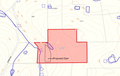
The applicant is proposing the construction of a new dam with a capacity of 40 megalitres (ML). A dam wall 7.5m high, 325m wide is proposed with the dam to be 52m long with a maximum depth of 8m. The applicant has not indicated a location for a pump shed. Although the applicant has stated that a scour pipe and overflow pipe are proposed, no details have been provided. A copy of the submitted details relating to the dam are attached.
ATTACHMENT: 9.5.1(1)
A site inspection was undertaken 6 July 2022 where is was found that some preliminary works had commenced at the northern end of the proposed dam. As these works exceed the required setback, no prior approval was required.
Council is requested to determine the application given that approval to the dam will require a relaxation of normal setback requirements relating to a property boundary.
PUBLIC Consultation Undertaken:
The application was advertised in accordance with Clause 9.6 of Local Planning Scheme No. 4 (the Scheme) and referred to Department of Water and Environmental Regulation (DWER) for a period of 42 days in accordance with the Planning and Development (Local Planning Schemes) Regulations 2015.
The application was also referred to the adjoining affected land owners for a 21 day comment period. Submissions were received from an adjoining land owner raising concerns regarding the dam’s structural integrity and from DWER. These comments are detailed in the comment section below and provided attached.
ATTACHMENT: 9.5.1(2)
COMMENT (Includes Options):
The provisions of the Scheme include the subject land within the Priority Agriculture zone.
As prescribed in clause 10.2 of the Scheme, local government is required to have regard to various matters when determining an application for planning approval. These matters include but not limited to:
(i) the aims and provisions of the Scheme and any other relevant Local Planning Scheme and operating within the Scheme Area;
(ii) the local government’s adopted Local Planning Strategy and any Local Planning Policy adopted by the local government under Clause 2.4….,
(x) the compatibility of a use or development with its setting including the potential impact on the use and enjoyment of adjacent and nearby land and taking into consideration of a Special Control Area; and
(xiv) whether the land to which the application relates is unsuitable for the proposal by reason of it being, or being likely to be, subject to flooding, tidal inundation, subsidence, landslip, bush fire or any other risk.
The following comments are offered to assist Council in determining the application.
Exempted Development
In accordance with Clause 8.4 of the Scheme, dams located within the Priority Agriculture and General Agriculture zones are exempt from requiring planning approval where the lower edge of the dam wall, and any other part of the dam including the stored water is further than 20 metres from boundaries of the subject land. Planning approval is required in this instance due to the applicant proposing setbacks of 5 metres to the southern boundary.
Setback Requirements
Part 5.34 of the Scheme prescribes the following setback requirements for development within the Priority Agriculture Zone:
(a) Minimum Front Setback – 30 metres;
(b) Minimum Side Setbacks – 10 metres;
(c) Minimum Rear Setback – 30 metres; and
(d) 100 metres from common boundaries with State Forest or National Park.
With setbacks of only 5 metres proposed to a neighbouring boundary, approval to the proposed development may only be granted through a relaxation of the setback requirements.
Relaxation of Standards
In accordance with Clause 5.5 of the Scheme, the local government may approve an application for planning approval, despite the application not complying with the standard or requirement prescribed under the Scheme. However prior to relaxing a standard, the local government must be satisfied that:
‘i) approval of the proposed development would be appropriate having regard to the criteria set out in clause 10.2; and
ii) the non-compliance will not have an adverse effect upon the occupiers or users of the development, the inhabitants of the locality or the unlikely future development of the locality.”
In this case, the relaxation of the boundaries is consistent with the requirements of clause 10.2, and the impact of an approval on either the subject land or adjacent property has been assessed against the Policy position.
Policy Assessment
The application has been assessed against the provisions of Local Planning Policy 6.1.22 – Dams (the Policy). The risk assessment indicates that the dam would be considered a moderate risk dam.
|
Risk Category |
Score |
|
Construction Type (Catchment Dam – Off-stream) |
1 |
|
Volume 10-100ML (40ML) |
2 |
|
Wall Height (5-10m) 7.5m |
2 |
|
Dam Wall Design (owner) |
3 |
|
Infrastructure Downstream (other dams) |
3 |
|
Overflow Infrastructure (by owner) |
1 |
|
TOTAL |
12 |
In accordance with provision 6.2 of the Policy, dams that score between 10 and 15 when assessed against the risk matrix are considered moderate risk. As outlined in the Policy it is recommended that advice notes be included on any approval relating to a moderate risk dam, advising landowners that:
· The landowner is responsible for the structural integrity of the dam construction; and
· It is recommended that the proposed structure be certified by an appropriately qualified contractor or engineer.
DWER Comments
DWER has offered a number of comments on the application, which are summarised as follows:
a) Clearing of native vegetation is subject to the Environmental Protection Act 1986 and clearing has occurred into the riparian zone of the water, beyond the extent authorised under clearing permit CPS 8482/;
b) The dam footprint is required to be consistent with the clearing approval obtained, should not interfere with the bed and banks of the waterway;
c) It is unclear as to whether the proposed dam capacity is consistent with requirements that the storage capacity shall not exceed the volume of water generated from the spring it is constructed over; and
d) The proponent is advised to be guided by Water Quality Protection Note 53 – ‘Dam Construction an operation in Rural Areas (Sept 2019).
As reflected within the DWER advice, the Department has raised potential issues in respect of clearing and water allocations. It is recommended that the applicant be advised to liaise with the Department over these matters.
Neighbour Submission
The following concerns were raised by an adjoining landowner in respect of the structural integrity of the dam, its design, the process of inspections and clearing of vegetation. The neighbour also stated that the construction of the dam had already commenced, however an inspection confirmed prior approval was not required for these works as detailed in Background section.
1. Structural Engineer
The neighbour has questioned whether the dam will be inspected by a qualified engineer to ensure that the dam is stable and compliant. As the dam was been assessed as a moderate risk, the applicant/landowner will be encouraged to have the dam certified, however this is not recommended to be an imposed condition of approval.
2. Shire Inspection
It has been questioned whether the Shire will inspect the dam following construction to ensure the 5 metre setback is being adhered to. It is not standard practice for Shire Officers to inspect following the completion of work, however they can be available for inspections of any development at the request of a landowner or concerned neighbour.
3. Water runoff
The neighbour has questioned if there is consequences if overflow waters or dam failure impacts on the neighbouring property. Shire Officer’s recommend standard advice that the construction of the dam is the responsibility of the applicant/landowner and that water should not be allowed to accumulate across property boundaries. Therefore, any liability in relation to the dam is the responsibility of the landowner.
4. Clearing
The neighbour has raised questions in respect to native vegetation clearing and its impact on the water quality of the creek line. In this respect DWER has issued a clearing permit and the vegetation is associated with an underground spring, rather than a water course.
5. Overflow and Spillway
The neighbour has cited the lack of details provided in terms of the scour pipe or overflow pipe. The applicant has verbally advised Shire Officer’s that the emergency overflow will be located centrally to the dam wall with an overflow height just above top of water level. The scour pipe will be located towards the north of the dam and will direct water into the creek.
Conclusion
Approval to the proposed dam is recommended on the basis that:
(a) Whilst submissions have been received, no objections have been received to the proposed relaxation of setbacks to the boundary; and
(b) It has been assessed as being a Moderate Risk Dam in accordance with LPP 6.1.22 – Dams.
In terms of potential issues relating to clearing, water course management and water rights raised by DWER, it is recommended that the applicant liaise with DWER over these matters.
STATUTORY ENVIRONMENT:
Planning and Development Act 2005 and Shire of Manjimup Local Planning Scheme No. 4.
Policy / Strategic Implications:
The application has been assessed against Local Planning Policy 6.1.22 – Dams.
Organisational risk management:
Nil.
Financial Implications:
The applicant has paid the relevant fees as per the Shire’s approved 2021-2022 fees and charges.
Sustainability:
Environmental: Potential Environmental Issues have been raised by DWER. It is recommended that the applicant liaise with the Department over these matters.
Economic: Establishing a water storage area will assist towards a suitable supply of water for agricultural and horticultural purposes.
Social: Nil.
VOTING REQUIREMENTS: SIMPLE MAJORITY
|
That Council in accordance with Part 10 and Clause 5.5 of the Shire of Manjimup Local Planning Scheme No. 4 grants development approval to the proposed Dam with a Reduced Setback at Lot 9477 Jones Road, Yanmah (TP89/2022) in accordance with the plans and specifications shown in Attachment 9.5.1(1) and subject to the following conditions and advice:
a) The development permitted shall be carried out generally in accordance with the plans and specifications submitted as listed below:
b) The setbacks shown on the approved plans are to be to the toe of the dam wall; c) Water from the dam is prohibited to accumulate across property boundaries; and d) All pumps and ancillary equipment and structures being setback from boundaries in accordance with the requirements of Shire of Manjimup Local Planning Scheme No. 4. Advice to Applicant: i) It is recommended that the applicant liaise with the Department of Water and Environmental Regulation over potential issues identified by the Department within their submission; ii) The applicant is encouraged to utilise the guidance provided through the Department of Water and Environmental Regulations Water Quality Protection Note – Dam Construction and Operation in Rural Areas (September 2019) as practical and appropriate to the site and proposal; iii) It is the responsibility of the landowner to ensure that the dam is safely constructed and maintained and that it is recommended that the proposed structure be certified by a suitably qualified contractor or engineer; and iv) It is recommended that the landowner incorporate suitable infrastructure to prevent overflowing of the dam wall.
|
|
ATTACHMENTS |
||
|
1⇨ |
Attachment No 1 - Copy of Submission and Dam Details |
5 Pages |
|
2⇨ |
Attachment No 2 - Copies of Submissions Received |
6 Pages |
38
9.5.2 Proposed Winery and Cellar Door at Lot 3 (41) Towie Road, Middlesex
|
PROPONENT |
Mr F J A Dei Tos |
|
OWNER |
Mr F J A Dei Tos |
|
LOCATION / ADDRESS: |
Lot 3 (41) Towie Road, Middlesex |
|
WARD: |
East |
|
ZONE: |
Priority Agriculture |
|
DIRECTORATE: |
Development and Regulation |
|
FILE REFERENCE: |
DA22/92 P53089 |
|
LEGISLATION: |
Planning and Development Act 2005 |
|
AUTHOR: |
Jocelyn Baister |
|
DATE OF REPORT: |
29 June 2022 |
|
DECLARATION OF INTEREST: |
The Manager of Libraries and Cultural Services is related to the proponent but is not involved in the assessment of planning applications. |
Background:
Council is requested to consider a proposed application to convert a 120m² portion of an existing Outbuilding on the subject land for use as a Cellar Door, with the remaining area used for Winery Production. A location plan is shown below.
LOCATION PLAN
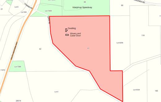
The subject property has an area of 38.64 hectares and currently consists of a dwelling and an Outbuilding with approximately 3.5 hectares of vineyard, a dam and the remaining land used for pasture/agistment. Plans of the proposed development is attached.
ATTACHMENT: 9.5.2(1)
The application is referred to Council for determination as Shire Officers do not have the delegated authority to determine an ‘A’ land use due to the application being for a change of use.
PUBLIC Consultation Undertaken:
The application was advertised in accordance with Clause 9.6 of the Shire of Manjimup’s Local Planning Scheme No.4 (the Scheme) for a 21 day period to adjoining landowners, a notice was placed on the Shire’s website, in the local paper and a sign was placed on site. Correspondence was also sent to the Ward Councillor.
At the close of the submission period, a letter of support has been received from an adjoining land occupier. A copy of the submission is attached.
ATTACHMENT: 9.5.2(2)
COMMENT (Includes Options):
In determining an application for planning approval, Clause 10.2 of the Scheme requires that various matters are taken into account, including but not limited to:
“(i) the aims and provisions of the Scheme and any other relevant Local Planning Scheme operating within the Scheme area; and
(vi) the local government’s adopted Local Planning Strategy and any Local Planning Policy adopted by the local government under Clause 2.4 ….; and
(x) the compatibility of a use or development with its setting including the potential impact on the use and enjoyment of adjacent and nearby land and taking into consideration any Special Control Area.”
To further assist Council in determining this application, the following comments are offered:
Consistency with Zoning
Lot 3 is zoned Priority Agriculture under the Scheme. The purpose of this zone is to “provide for the sustainable use of high quality agricultural land, particularly where water resources exist, preserving agricultural production and allowing for new agricultural production by securing suitable land and water resources” and to “provide for intensive agricultural and horticultural production including market gardens, orchards and vineyard enterprises.”
The proposal is therefore consistent with the purpose and objectives of the zone.
Land Use Provisions
The proposed winery is consistent with the land use classification of “Winery” being a premises used for the production of viticulture produce and may include the sale of the produce.” A Winery is an ‘A’ use within the Priority Agriculture zone that is a use that is “not permitted unless the local government has exercised its discretion by granting planning approval after giving special notice in accordance with Clause 9.6.”
Cellar Door Sales
Local Planning Policy 6.1.11 Rural Land Uses provides guidelines for the establishment of Cellar Door Sales. The objectives of the Policy is to ensure that:
· Cellar door sales established on Priority and General Agriculture zoned land are designed to be in keeping with the rural character and amenity of the area; and
· That Cellar Door sales establishments are located only on properties zoned Priority and General Agriculture where there is an existing associated vineyard and/or Winery.
The proposed Winery can essentially be considered a Cellar Door sales development as the wine to be sold will use grapes grown on the property. Cellar Door sales with tasting facilities will require the appropriate classification under the Food Regulations and both a Section 39 and 40 Certificate will also be required to be obtained from Council. It is recommended that advice regarding this be included in any approval granted by Council.
Hours of Operation
The Cellar Door is proposed to operate by appointment only and predominantly only on weekends.
Car Parking / Site Access
In accordance with Part 5.17 of the Scheme, on-site parking is required to be provided at rates identified for land uses within Table 2 – Car Parking Requirements. As neither a Winery nor Cellar Door Sales are listed uses within Table 2, the level of parking required shall be “determined by the local government after consideration of the parking need generated by the use and/or outlined in a Local Planning Policy.”
Local Planning Policy 6.1.11 identifies that Cellar Door sales are to provide one car parking space per 25m² of floor area. As the Cellar Door is 120m², it will require the provision of five parking spaces in order to meet the Policy. The applicant has identified within the application that four car parking spaces, will be provided to service both the Cellar Door Sales and the Winery.
It is considered that the proposed number of car parking spaces will be adequate to service the operations of the Winery and Cellar Door as the opening hours are by appointment only, meaning the applicant can control the number of patrons.
Parking Construction Standard
In accordance with clause 5.17.9 of the Scheme, except as otherwise approved by the local government, parking areas are to be constructed with a sealed surface comprising bitumen seal, concrete, brick paving or pea-gravel seal on a compacted base with satisfactory drainage and line marking.
As reflected within Local Planning Policy 6.1.11, the use of compacted gravel is generally accepted in rural areas, with the form of construction being consistent with the rural amenity. However, the accessible car parking space will need to be sealed to comply with Australian Standards (AS1428.1 – 2009).
Should approval be granted, it is recommended a condition be included to require the marking of the identified parking bays and sealing of the accessible bay and associated pathway(s) to ensure compliance with AS1428.1 – 2009.
Impact on Amenity
The operation of a Winery has the potential to impact on the amenity of an area through noise, dust and odour. In order to limit the potential impact on sensitive premises such as a nearby dwellings, the Environmental Protection Authority (EPA) recommends a buffer of between 200 and 500 metres depending on the size and type of product.
If approved, the proposed Winery will be located toward the middle of the subject property, setback 150m from the front boundary and over 200m from the nearest neighbouring dwelling to the south west. Whilst the proposed development complies with the minimum buffer requirements as recommended by the EPA, appropriate conditions are recommended to ensure the potential for impact is managed and mitigated.
Provided that the facility and its associated waste are managed appropriately, the development is unlikely to result in detrimental impacts on the current amenity of the area.
Effluent Disposal
The proposed use will increase the number of people attending the property, resulting in an increase in the amount of waste water produced on-site. The existing on-site effluent disposal system may require upgrading to cater for this. It is therefore recommended that an advice note be included identifying the need to provide an adequate wastewater treatment system catering for the proposed use to the satisfaction of the Shire of Manjimup.
Waste Disposal
Wineries and their processes create both solid wastes in the form of grape stalks, pomace and seeds and liquid waste from both the process and maintenance of the winery and system.
Wineries that produce over 350 kilolitres of wine or alcoholic beverages per year require a works approval and license under the Environmental Protection Regulations 1987. This product equates to a fruit crush of around 500 tonnes per year, creating between 200 and 500 kilolitres of wastewater. In addition premises that produce more than 1,000 litres per day of wastewater are required to obtain approval for their wastewater systems from the Department of Water and Environmental Regulation. Applications for such approval must be supported by detailed management plans.
For all smaller operators, the management of waste products and wastewater is required to comply with the Department of Water’s Water Quality Protection Note relating to wineries and distilleries. It is recommended that this requirement be brought to the applicant’s attention as an advice note.
In the case of the current proposal, the Winery is to be located on a property with only some 3.5ha of vines currently established. With grapes yielding on average under 6 tonnes per hectare in the South West, the proposed Winery is likely to process up to 21 tonne of grapes, well below the level requiring Environmental Protection Authority approval.
Other Environmental Health Requirements
The Winery will be required to register as a food business with the Shire as it will involve the sales of goods to the public for general consumption purposes. The Winery will also be required to apply to the local government to attain approvals under Section 39 and 40 of the Liquor Licensing Act 1988 for a permit to allow the legitimate sales of alcohol.
Should Council resolve to approve the establishment of the Winery with Cellar Door Sales, it is recommended that advice for the above detailed permits and licences to be obtained be included as advice to the applicant.
Building Requirements
The area of the Cellar Door exceeds 10% of the overall building floor area and a building permit for a reclassification will be required.
Conclusion
Given the proposal is not expected to impact on the amenity of the area and conforms to the provisions of the Scheme, Shire Officers recommend that approval be granted subject to the conditions and advice described in the Comment section above.
STATUTORY ENVIRONMENT:
Planning and Development Act 2005 and Shire of Manjimup Local Planning Scheme No.4.
Policy / Strategic Implications:
The application has been assessed against the relevant provisions of Local Planning Policy 6.1.11 Rural Land Uses as discussed in the comment section above.
Organisational risk management:
Nil.
Financial Implications:
The required development application fee has been paid by the applicant.
Sustainability:
Environmental: Provided associated waste is disposed of appropriately, no environmental impacts are anticipated from approval of the application as submitted.
Economic: The application as submitted will assist the current landowners in continuing ongoing rural production on the property.
Social: The Winery is not expected to have any impact upon the amenity of the surrounding area
VOTING REQUIREMENTS: SIMPLE MAJORITY
|
That Council in accordance with Part 10 of Shire of Manjimup Local Planning Scheme No.4 grants development approval to the Change of Use – ‘Outbuilding to a Winery and Cellar Door’ on Lot 3 (41) Towie Road, Middlesex (Application TP92/2022) as Attached at 9.5.2(1) and subject to the following conditions: a) The development permitted shall be carried out generally in accordance with the plans and specifications as listed below:
b) All car parking areas and access ways shall be marked and maintained for their stated purpose at all times to the satisfaction of Council and shall not be used for the display or general storage purposes; c) A minimum of 1 accessible compliant car bay shall be maintained on site at all times in accordance with the Australian Standard 2890.1 – 2009 and connected to a continuous accessible path to the main entrance of the building or facility; d) The accessible parking bay together with the accessible path referred to in condition c) above shall be constructed with a sealed surface comprising either a bitumen seal, concrete, brick paving or pea-gravel seal on a compacted base to the satisfaction of the Shire of Manjimup; e) The use hereby permitted shall be managed as to not cause injury to or prejudicially affect the amenity of the locality by reason or appearance or the emission of smoke, fumes, noise, vibration, odour, vapour, dust, waste water, waste products or otherwise; f) All liquid and solid wastes generated by the Winery processes hereby approved shall be disposed of in accordance with the Department of Water – Water Quality Protection Note relating to Wineries and distilleries; and g) No polluted drainage shall be discharged beyond the boundaries of the land from which it emanates or into watercourse or easement drain, but shall be so treated and/or absorbed on that lot to the satisfaction of the Shire. Advice to applicant: i. In the event the winery hereby approved results in the generation of more than 1,000 litres of wastewater, approval of the wastewater system must be obtained from the Department of Water and Environmental Regulation; ii. This development approval is NOT a building permit. A certified building permit for the change of use must be formally presented to and approved by Building Services to formalise the development; iii. The proponent is advised that Section 39 and 40 (Liquor Licensing Act, 1988) ‘Certificates of Local Planning Authority’ will also be required to facilitate the operation of any Approved ‘Cellar Door Sales’ use; iv. The development must comply with the Food Act 2008 and Food Regulations 2009. In this regard the applicants are requested to contact the Shire’s Environmental Health Services for further information; and v. The applicant is advised that the development is to comply with all relevant provisions of the Health (Miscellaneous Provisions) Act 1911.
|
||||||||||||
|
|
|
ATTACHMENTS |
||
|
1⇨ |
Attachment 1 - Plans and Information of Proposed Development |
3 Pages |
|
2⇨ |
Attachment 2 - Submission Received |
1 Page |
42
9.5.3 Proposed Animal Establishment (Dog Breeding) at Lot 1 (33) Vic Road, Middlesex
|
PROPONENT |
Ms M Gandy |
|
OWNER |
Mr B M Linthorne and Ms M Gandy |
|
LOCATION / ADDRESS: |
Lot 1 (33) Vic Road, Middlesex |
|
WARD: |
East |
|
ZONE: |
Priority Agriculture |
|
DIRECTORATE: |
Development and Regulation |
|
FILE REFERENCE: |
DA22/90 P54485 |
|
LEGISLATION: |
Planning and Development Act 2005 |
|
AUTHOR: |
Jocelyn Baister/Brian Robinson |
|
DATE OF REPORT: |
29 June 2022 |
|
DECLARATION OF INTEREST: |
Nil |
Background:
Council is requested to consider an application for a proposed Animal Establishment at Lot 1 (33) Vic Road, Middlesex. The subject property is 8.48ha in area and is located at the intersection of Vic Road and Kurandra Road, Middlesex. Surrounding land uses consist of a variety of farming activities. A location plan is shown below.
LOCATION PLAN
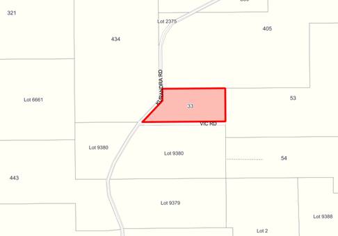
The applicant is proposing to seeking approval for the running of a dog breeding business where they intend to keep six (6) dog on the property and within the dwelling and in a 317m² fenced enclosure. Only two of the dogs are currently used for breeding, however there is potential for this to change over time. A copy of the development plans and information is provided attached.
ATTACHMENT: 9.5.3(1)
Council is requested to consider the application as Shire Officers do not have the delegated authority to determine applications for Animal Establishments. A concurrent application for a Kennel License under the Shire of Manjimup Dog Local Law 2004 will be considered by the Chief Executive Officer and will be determined having regard to Council’s decision on this application.
PUBLIC Consultation Undertaken:
The proposal was advertised in accordance with clause 9.6 of the Shire of Manjimup Local Planning Scheme No.4 (the Scheme) to adjoining landowners for a period of 21 days. No submissions have been received
COMMENT (Includes Options):
The subject land is zoned Priority Agriculture by the provisions of the Scheme.
Matters to be Considered
In determining an application for planning approval, the local government is required to have regard to various matters as outlined within clause 10.2 of the Scheme. These matters include, but are not limited to:-
(i) the aims and provisions of the Scheme and any other relevant Local Planning Scheme operating in the district; and
(xv) the preservation of the amenity of the locality.
Zoning Purpose
As set out in the Scheme the purpose of the zone is to provide for the sustainable use of high quality agricultural land, particularly where water resources exist, preserving existing agricultural production and allowing for new agricultural production by securing suitable land and water resources.
Being less than 8.5 hectares and with a limited supply of water resources it is unlikely that the property can be used for intensive agricultural activities. Opportunities for appropriate ongoing rural uses are therefore limited.
Land Use Considerations
An Animal Establishment is defined as “a premises used for the breeding, boarding, training or caring of animals for commercial purposes but does not include animal husbandry – intensive or veterinary centre.” An Animal Establishment is an ‘A’ land use within the Scheme meaning, “that the use is not permitted unless the local government has exercised its discretion by granting planning approval after giving special notice in accordance with clause 9.6.”
Impact on Amenity
Animal Establishments have the potential to impact on the amenity of adjacent land, particularly through noise associated with communal barking should that occur. In this case there are four dwellings located between 350m and 800m from the facility.
Shire records indicate that no complaints have been received regarding noise. Appropriate ongoing management of the activity will ensure the activity is undertaken in a manner that is consistent with the objectives and purpose of the zone and impacts on the amenity of the area are minimised.
Compliance with Dogs Local Law
An application will be made for a Kennel Licence in accordance with the provisions of the Shire of Manjimup Dog Local Law 2004. Should Council grant planning approval for the land use, the Kennel Licence would be assessed and determined under delegation, with any approval being subject to a range of conditions to ensure ongoing compliance.
Conclusion
Given the separation distance to adjoining dwellings and the appropriateness of the zone approval is recommended subject to conditions to limit the number of dogs to six as proposed. Additional conditions to require suitable ongoing management of the activity and prohibit the boarding of animals are also recommended.
STATUTORY ENVIRONMENT:
Planning and Development Act 2005 and Local Planning Scheme No.4
Policy / Strategic Implications:
The proposal will assist in the delivery of the following Strategies under the Shire of Manjimup Strategic Community Plan 2021-2031:
B12. Provide development opportunities and support local small businesses to thrive.
Organisational risk management:
Nil.
Financial Implications:
The required development application fees have been paid by the applicant.
Sustainability:
Environmental: Nil.
Economic: The proposed business will provide the landowner with an additional source of income.
Social: Nil.
VOTING REQUIREMENTS: SIMPLE MAJORITY
|
That Council in accordance with Part 10 of the Shire of Manjimup Local Planning Scheme No. 4 grants planning approval for an Animal Establishment (Breeding) at Lot 1 (33) Vic Road, Middlesex (TP90/2022) as outlined in the plans and specifications attached at 9.5.3(1) and subject to the following conditions: a) The maximum number of adult dogs housed at the premises being six (6) at any one time; b) The kennels are not to be used as commercial boarding kennels at any time without prior planning approval; and c) The activity shall be undertaken and managed in such a way as not to detrimentally impact of nearby homes on adjacent properties. Advice to Applicant i. The development the subject of this planning approval must comply with the requirements of the Health (Miscellaneous Provisions) Act 1911 and Shire of Manjimup’s Health Local Laws 2020. ii. The development the subject of this planning approval must comply with the requirements of the Shire of Manjimup’s Dog Local Law 2004.
|
|
ATTACHMENTS |
||
|
1⇨ |
Attachment 1 - Plans and Information for Proposal |
7 Pages |
49
9.5.4 Proposed Plantation at Lot 2375 (405) Kurandra Road, Middlesex
|
PROPONENT |
Mr J Reeve |
|
OWNER |
Mr J Reeve |
|
LOCATION / ADDRESS: |
Lot 2375 (405) Kurandra Road, Middlesex |
|
WARD: |
East |
|
ZONE: |
Priority Agriculture |
|
DIRECTORATE: |
Development and Regulation |
|
FILE REFERENCE: |
DA22/73 P54973 |
|
LEGISLATION: |
Planning and Development Act 2005 |
|
AUTHOR: |
Jocelyn Baister/Brian Robinson |
|
DATE OF REPORT: |
30 June 2022 |
|
DECLARATION OF INTEREST: |
Nil |
Background:
The subject property is 62.3ha in area, approximately 5km south east of the Manjimup town centre. The property is currently being used for the agistment of cattle and contains a dwelling, a number of outbuildings, two dams and remnant vegetation. As reflected on the location plan below, a western power easement and water course traverse the land.
LOCATION PLAN
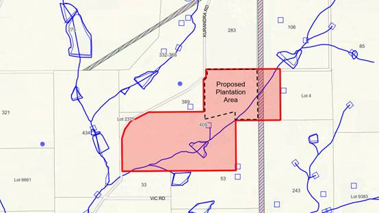
It is proposed to establish a 15 hectare Plantation of Eucalyptus globulus (Blue Gum) immediately west of the western power easement, with planting to occur at a rate of 1,100 stems per hectare. A 15 metre firebreak is proposed and a setback of 6 metres is proposed from the existing water course. Copies of the Site and Plantation Management Plans are attached together with the copy of a DWER clearing permit relating to the plantation area.
ATTACHMENT: 9.5.4(1)
Council is requested to determine the application, as Shire Officers do not have the delegated authority to determine proposals for Agroforestry/Tree Plantation land uses.
PUBLIC Consultation Undertaken:
The application was advertised in accordance with Clause 9.6 of Local Planning Scheme No. 4 (the Scheme) for a 21 day period. Correspondence was also forwarded to Department of Biodiversity, Conservation and Attractions (DBCA), Main Roads WA (MRWA), Department of Water and Environmental Regulation (DWER) and the Department of Primary Industries and Regional Development (DPIRD).
Submissions have been received from all agencies referred to above. Whilst the DPIRD correspondence simply states that the department has no objection, all other departments have offered comments on the proposal. Copies of the submissions received as shown attached, whilst the content of those submissions is addressed within the Comment section of this agenda item. No other submissions were received.
ATTACHMENT: 9.5.4(2)
COMMENT (Includes Options):
The subject land is zoned Priority Agriculture under the Scheme. The purpose of this zone is to provide for the sustainable use of high quality agricultural land, particularly where water resources exist, preserving the existing agricultural production and allowing for new agricultural production by securing suitable land and water resources.
Matters to be Considered
In determining an application for planning approval, the local government is required to have regard to various matters as outlined within clause 10.2 of the Scheme. These matters include, but are not limited to:-
(i) the aims and provisions of the Scheme and any other relevant Local Planning Scheme operating in the district;
(vi) the local government’s adopted Local Planning Strategy and any Local Planning Policy adopted by the local government under clause 2.4…;
(xiii) the likely effect of the proposal on the natural environment and any means that are proposed to protect or to mitigate impacts on the natural environment; and
(xv) the preservation of the amenity of the locality.
Land Use Definition
The Scheme definition of “Plantation” refers to the definition in the Code of Practice for Timber Plantations in Western Australia, which is as follows:
“ a stand of trees of ten hectares, or larger, that has been established by sowing or planting of either native or exotic tree species selected and managed intensively for their commercial and/or environmental benefits. A plantation includes roads, tracks, firebreaks and small areas of native vegetation surrounded by plantations. Implicit in this definition is the recognition that the plantation will be harvested.”
Land Use Permissibility
The Scheme identifies a Plantation as an ‘A’ use within Priority Agriculture zone. That is a use, which is not permitted, unless Council has exercised its discretion by granting planning approval after publicly advertising the application in accordance with the requirements of Clause 9.6 of the Scheme.
Local Planning Policy 6.1.11 Rural Land Uses (the Policy)
Part C of the Policy outlines the Shire’s position in relation to the development of tree plantations on agricultural land through the Shire, the standards to be applied to all future development of this type and the process required to obtain the necessary approvals. The following comments are provide in respect of the Policy requirements:
Access
The applicant has supplied a management plan for the plantation. Although the harvest plan has not been determined, harvest access will be via Kurandra Road and the applicant has acknowledged that extra mass haulage permits may be required as a result of consultation with Main Roads WA and the Shire. To ensure appropriate haulage routes and practices are utilised during harvesting, it is recommended that a condition is imposed requiring the submission of a transport management plan to the satisfaction of the Shire.
Fire Risk and Management
The Plantation Management Plan includes fire protection measures that appear to be consistent with the Bush Fires Act and “Guidelines for Plantation Fire Protection”. Mitigation techniques include a 15 metre wide perimeter firebreak, access to water points and an existing dam immediately south of the plantation for firefighting and procedures for minimising risk and in the event of fire attack.
Should the application be approved, it is recommended that conditions be imposed requiring ongoing compliance with the requirements of the Code of Practice and Guidelines along with a requirement that all fire management measures listed in the Fire Management Plan are to be implemented.
Visual Impact
The provisions of LPP 6.1.11 outline that development applications for plantations will be assessed in terms of their visual impacts where the plantation is near a townsite adjoining or are near a designated regional road. Given the location of the proposed plantation will not be visible from a townsite or regional road, no further assessment of the visual impact is required.
Natural Resource Management
The applicant is proposing a 6 metre setback to the existing water course, this is compliant with LPP 6.1.11.
Submissions
The content of submissions received from MRWA, DPIRD and DWER are detailed and assessed below.
MRWA
MRWA have advised that they have no objection to the proposal, subject to the proponent complying with any requirements of Main Roads Heavy Haulage section. It is recommended that the applicant be advised accordingly.
DBCA
DBCA notes that the proposed “Fire Protection Measures” make reference to the fact the nearest Department of Parks and Wildlife Office is located in Manjimup. In response the Department advises that:
a) Whilst the department can be available to assist in bushfire control activities within the plantation, this will depend on its own commitments; and
b) There should be no reliance on the department’s resources being available to attend fire emergency situations on the property.
It is recommended that the applicant be advised accordingly.
DBCA also recommends that DWER be consulted to ensure compliance with the clearing of native regulations if any native vegetation is to be removed. Shire Officers have consulted with DWER, with their response detailed below.
DWER
DWER has identified that the proposal has the potential to impact on the environment and water resource values management and has provided advice on the key issues as follows:
a) The clearing permit (CPS9090/2) is subject to a condition requiring the tree shown hatched in red on page 7 of their submission, being an identified as a potential black cockatoo habitat tree;
b) The clearing permit excludes 5 trees identified on page 7 of their submission, if these trees are native;
c) A license to clear vegetation identified in point (b) above is required under the Country Areas Water Supply Act 1947;
d) The proponent is advised to contact DWER’s Bunbury water licensing branch in the event the proponents are seeking to take water over and above their licensed allocation;
e) A permit to interfere with the beds and banks of the watercourse is required prior to the clearing of riparian vegetation or interference with the beds and banks of the watercourse;
f) A 6 metre buffer is required from the edge of the Water Course in accordance with the Code of Practices for Timber Plantations in Western Australia; and
g) The proponent is advised to refer to the Code of Practice in Western Australia with particular reference to buffers from the edge of the watercourse and the fact machinery should not enter the riparian zone or designated buffers.
It is recommended that the applicant be provided with a copy of the advice received from DWER.
Conclusion
The proposed plantation is a use that can be approved within the Priority Agriculture Zone. Given that the application is consistent with the provisions and considerations outlined by the Shire’s LPP 6.1.11 and appears to be consistent with the Industry Code of Practice, conditional approval is recommended.
STATUTORY ENVIRONMENT:
Planning and Development Act 2005 and Shire of Manjimup Local Planning Scheme No. 4.
Policy / Strategic Implications:
Timber Plantations within the rural areas of the Shire are guided by the provisions of the Shire of Manjimup Local Planning Policy 6.1.11 - Rural Land Uses. The application’s compliance with this policy is addressed within the comment section of this agenda item.
Organisational risk management:
Nil.
Financial Implications:
The required Development Application fee has been paid by the applicant.
Sustainability:
Environmental: Provided the matters relating to vegetation, as highlighted by DWER are addressed and proposed use is managed appropriately, no detrimental environmental impacts are anticipated.
Economic: The application if approved will contribute to the area’s timber products industry and will continue to diversify the economy by providing employment opportunities within the Shire.
Social: It is considered that proposal is compatible with the rural nature of the area and existing land uses abutting the site.
VOTING REQUIREMENTS: SIMPLE MAJORITY
|
That Council in accordance with Part 10 of Shire of Manjimup Local Planning Scheme No. 4 grants planning approval for a Plantation (Eucalyptus globulus) at Lot 2375 (405) Kurandra Road, Middlesex (TP77/2022) in accordance with the submitted plans and specifications and subject to the following conditions: a) The development hereby approved is to be carried out generally in accordance with the plans and specifications submitted with the application and these shall not be altered and/or modified without the prior knowledge and written consent of the Shire of Manjimup.
b) The tree identified as potential habitat for the Black Cockatoo by the Department of Water and Environmental Protection in their email dated 8 July 2022 being retained on-site; c) In conducting the activity hereby approved the plantation Operator/Manager is required to comply with all relevant legislation, and to have particular regard to the general and reasonable amenity expectations of those who may be resident in the vicinity; d) A separate ‘Harvesting Plan’ is to be submitted to the Shire of Manjimup a minimum of 24 months prior to the anticipated commencement of the harvesting of the subject Plantation and not less than 12 months prior to the commencement of harvesting operations formal notification of the intention to harvest shall be given to Shire of Manjimup. The ‘Harvesting Plan’ is to be prepared in accordance with the latest “Code of Practice for Timber Plantations” (or equivalent) that is applicable at that time; e) Prior to the commencement of harvesting, a transport management plan identifying heavy vehicle movement network shall be prepared, approved and implemented to the satisfaction of the Shire of Manjimup; f) Fire management measures outlined in the application are to be implemented so as to meet the performance standards outlined in the Department of Fire and Emergency Services Guidelines for Plantation Fire Protection to the satisfaction of the Shire of Manjimup; g) At the completion of any harvesting the area which has been harvested shall be reinstated to the requirements and satisfaction of the responsible authority. In particular: i. all waste shall be disposed of to the satisfaction of the responsible authority and should not be placed in or near any water course; ii. any surplus tree branches shall be adequately disposed and shall not be left on site if they constitute a fire hazard; and iii. all temporary roads shall be reinstated and left providing for adequate drainage and soil stability without the need for continuous maintenance; and h) Any proven damage to the local road network caused by vehicles associated with the Plantation is to be repaired at the applicant’s cost to the satisfaction of the Shire of Manjimup. Advice to Applicant: (i) The Department of Water and Environmental Regulation has advised that: · the current clearing permit does not cover removal of five trees identified on page 7 of their submission shown at Attachment: 9.5.4(2), and should they be native trees and further approval will be required under the Country Areas Water Supply Act 1947; and · It notes that the vegetation to be cleared intersects with the identified watercourse on the property and that prior to any interference with the bed and banks of the watercourse under the Rights in Water & Irrigation Act 1914. (ii) That the operation of the Plantation including its harvest is required to comply with the Environmental Protection (Noise) Regulations, 1997; (iii) Main Roads Western Australia requires that transportation of harvested plantation material is required to comply with any requirements of Main Roads Heavy Haulage section; and (iv) The attention of the Plantation Operator / Manager is drawn to the need to comply with the requirements of any ‘Firebreak Notice’ issued by the Shire of Manjimup under the provisions of the “Bush Fires Act 1954”. Furthermore, the Plantation Operator / Manager is required to advise Shire of Manjimup’s Ranger of any commercial harvesting activities that may be proposed during restricted or prohibited burning seasons.
|
|
ATTACHMENTS |
||
|
1⇨ |
Attachment No 1 - Site Plan, Plantation Management Plan and DWER Clearing Permit |
10 Pages |
|
2⇨ |
Attachment No 2 - Copies of Submissions Received |
12 Pages |
55
9.5.5 Proposed Subdivsion/Amalgamation (boundary adjustment) - Lot 103, 12966, 1660, 1659 & Nelson Location 1181 Dawsons Road, Balbarrup
|
PROPONENT |
John Towie |
|
OWNER |
DA Edwards |
|
LOCATION / ADDRESS: |
Lots 103, 12966, 1660, 1659 and Nelson Location 1181 Dawsons Road, Balbarrup |
|
WARD: |
North Ward |
|
ZONE: |
Priority Agriculture |
|
DIRECTORATE: |
Development & Regulation |
|
FILE REFERENCE: |
DA22/104 |
|
LEGISLATION: |
Planning and Development Act 2005 |
|
AUTHOR: |
Brian Robinson |
|
DATE OF REPORT: |
6 July 2022 |
|
DECLARATION OF INTEREST: |
The Director of Business is an adjacent landowner but has not participated in the preparation or review of this item. |
Background:
The subject land comprises five (5) lots located on Dawsons Road, Balbarrup approximately 4.5km north-east of the Manjimup townsite as shown below. Council is requested to consider the proposal given that in accordance with current delegations, proposals involving five (5) or more lots must be referred to Council.
Location Plan
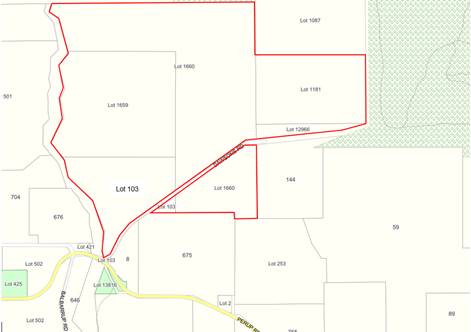
The Western Australian Planning Commission (WAPC) is seeking the comments on a proposed subdivision/amalgamation in accordance with the attached plan. A plan depicting the current and proposed lots is shown attached.
ATTACHMENT: 9.5.5 (1)
Existing Lot Descriptions
The following description of the existing lots is provided:
1. Lot 103 (33.003ha), mostly north of Dawsons Road with an existing dam, a dwelling and rural outbuildings. A central irrigation pivot located on Lot 1659 to the north encroaches into the property. Approximately 1.3ha of the lot is located south of Dawsons Road is well vegetated;
2. Lot 1659 (64.7910ha) is landlocked, developed for agricultural purposes and cleared of vegetation except a 4.3ha area in the south-east corner;
3. Lot 1660 being approximately 119ha, with 20.8830ha located south of Dawsons Road. North of Dawsons Road is developed for agricultural purposes and contains a rural shed;
4. Nelson Location 1181, also being land locked, which is developed for agricultural purposes in conjunction with Lots 1660 and 1087 and contains a significant dam. A dam, which is primarily located on Lot 1660 to the west enters the south western corner of the lot; and
5. Lot 12966 (approximately 5.4525ha) is an undeveloped sliver of land that separates Lot 1181 to the north from Dawsons Road. A dam, primarily located on Lot 1660 enters the north western corner of the property.
Proposed Lot Descriptions
The following is a description of the proposed lots and the boundary adjustments to create them:
a) Lot 100, created from Lot 1660 minus:
(i) approximately 7ha for inclusion into Lot 1659 in order to provide that lot with road frontage; and
(ii) the area located south of Dawsons Road along with 6ha north of Dawsons Road;
a) Lot 101, to be created by combining Lot 1659, together with portion of Lot 1660 to provide road frontage and portion of Lot 103 containing the central irrigation pivot;
b) Lot 102, combining Nelson Locations 1181 and Lot 12966;
c) Lot 104, combining the land described in point (a)(ii) together with that portion of Lot 103 located south of Dawsons Road; and
d) Lot 106, being the current lot 103, minus that portion south of Dawsons Road and the portion containing the portion of the irrigation pivot primarily located on current Lot 1659.
An aerial photograph of the land is shown attached.
ATTACHMENT: 9.5.5(2)
PUBLIC Consultation Undertaken:
Nil.
COMMENT (Includes Options):
The provisions of Local Planning Scheme No 4 (the Scheme) include the subject land within the Priority Agriculture Zone. When considering applications for subdivision, Council is required to have regard to provisions of the scheme that relate to subdivision of Priority Agriculture Land, relevant State Planning and Development Control Policies.
Zone Purpose and Objectives
The purpose of the Priority Agriculture Zone is to “provide for the sustainable use of high quality agricultural land, particularly where water resources exist, preserving existing agricultural production and allowing for new agricultural production be securing suitable land and water resources.” Consistent with this purpose, the Scheme outlines objectives for managing and guiding land use and development within the Priority Agriculture Zone, including:
(i) Require planning to avoid the introduction of land uses and subdivision not relates to agriculture including rural residential proposals;
(v) Require protection and enhancement of biodiversity; and
(viii) Support boundary adjustments, realignments, farm restructuring and new lot creation which promotes effective land management practices, environmental and landscape enhancement and infrastructure provision.
Scheme Provisions Relating to Subdivision
Guidelines for the subdivision of Priority Agriculture land are outlined within Section 5.34.2 of the Scheme. The requirements outlined which are relevant to the current application are:
1. There is a presumption of subdivision of land within the Priority Agriculture Zone unless the local government is satisfied that:
a) The lots are for farm boundary adjustment; or
b) the adjustment of lot boundaries where the application, if approved will not result in the creation of additional lots; or
c) of the need to excise a conservation lot; or
d) the subdivision is necessary to enable the carrying out of an intensive agricultural pursuit and is in accordance with the local governments Local Planning Policy – Intensive Agriculture.
2. The local government will not support subdivision in the zone, which in its opinion will have the potential to adversely affect the rural landscape or be prejudicial to the agricultural use of the land or locality; and
3. In accordance with clause 5.34.2.3, the local government will not support the subdivision of land within the Priority Agriculture zone unless the proposal complies with either the Local Planning Strategy, the Warren-Blackwood Rural Strategy or State Planning/Development Control Policies.
The proposed subdivision/amalgamation is consistent with the guidelines set out in Section 5.34.2 of the Scheme as outlined in points 1 and 3 above. The proposed creation of Lot 104 with portion of the lot north of Dawsons Road does however have potential to impact on agricultural activities on the adjacent lots. Further information on this potential issue is detailed under the heading Lot 104 below.
State Planning Policy No 2.5 – Rural Planning (SPP No 2.5)
The objectives of SPP No 2.5 are based on the protection of the rural land resource and agricultural production. The objectives of the Policy that are relevant to the current proposal are:
(a) Support existing, expanded and future primary production through the protection of rural land, particularly priority agricultural land and land required for animal premises and/or the production of food;
(e) Avoid and minimise land use conflicts;
(g) Protect and sustainably manage environmental, landscaping and water resource assets; and
The application as submitted is consistent with the objectives of the policy, although the creation of Lot 104 has potential for land use conflict to result.
Development Control Policy 3.4 – Subdivision of Rural Land (DC3.4)
The purpose of DC3.4 is to provide further detailed guidance in respect of the subdivision of rural land in accordance with the objectives of SPP 2.5. As the proposal will result in the realignment of lot boundaries with no increase in the number of lots, the proposal is generally consistent with the requirements of DC3.4.
State Planning Policy No 3.7 – Planning in bushfire prone areas (SPP No 3.7)
This policy outlines land use planning considerations in respect of bushfire risk management in Western Australia. Bushfire Prone mapping provided by the Department of Fire and Emergency Services indicates that significant areas of the subject land are Bushfire Prone Areas. The Bushfire Prone mapping indicates that the majority of proposed Lot 103 and the whole of proposed lot 104 are wholly contained within the Bushfire Prone area.
In accordance with SPP No 3.7, applications for subdivision relating to land identified as Bushfire Prone should be supported by an assessment of the Bushfire Attack Level through a Bushfire Management Plan. Supporting documentation provides a Bushfire Attack Level for proposed Lot 103 which contains an existing dwelling. However no assessment of the Bushfire Attack Level has been provided in respect of proposed Lot 104.
Through discussions with the applicant, Shire Officers have been advised that proposed Lot 104 has been designed to include a 6ha portion of land north of Dawsons Road to provide a home site given that all other land within the proposed lot is heavily vegetated with native vegetation. Creation of an acceptable site for the construction of a home south of Dawsons Road will involve clearing.
Lot 104
As detailed, proposed Lot 104 includes approximately 6ha of land north of Dawsons Road to provide a suitable site for the construction of a future home. A home in this location would however potentially be impacted on by the existing intensive agricultural activities and a nearby irrigation pump located adjacent to the existing dam on proposed Lot 100.
Given the limited cleared area within proposed Lot 104 and the fact there is no existing dam within the property, it is likely Lot 104 could be purchased and used for a lifestyle property. There is therefore potential for land use impact to occur. Options to address this impact are summarised as follows:
a) The use of a memorial on title advising of the existing agricultural activities and the potential for land use conflict. This would however not prevent future purchases lodging complaints regarding those activities; or
b) Limiting proposed Lot 100 to south of Dawsons Road, maximising the distance of any future home from agricultural activities. However this would involve the need for the clearing of vegetation to mitigate the risk of bushfire.
As an alternative, if Lot 100 was restricted to south of Dawsons Road, it could be identified as a conservation lot and acquired by government agencies or others for environmental offsets.
Existing Dams
The submitted plans show the common boundary of Lot 100 and 102 entering an existing dam. To ensure appropriate ongoing management of the water recourse, it is recommended that the proposal be amended to include wholly include the existing dam within proposed Lot 100. The applicant has verbally indicated that the landowner is prepared to amend the proposal accordingly.
Conclusion
The application for subdivision/amalgamation is generally consistent with the requirements of the Scheme and relevant State Planning Commission Policy, however:
a) The common boundary of proposed Lot 100 and 102 should be adjusted to ensure the existing dam is wholly contained in Lot 100; and
b) The creation of a home-site within proposed Lot 104 north of Dawsons Road may result in land use conflict.
As the only alternative for a home on proposed Lot 104, south of Dawsons Road, require clearing, it is recommended that the application be supported subject to a memorial on the title of Lot 104 advising of the existing agricultural activities and the potential for conflict. Notwithstanding this, it is recommended that the applicant consider the creation of Lot 104 south of Dawsons Road as a conservation lot (i.e. without a home site).
STATUTORY ENVIRONMENT:
Planning and Development Act 2005.
Policy / Strategic Implications:
As detailed in the Comment Section of this report.
Organisational risk management:
Nil.
Financial Implications:
Nil.
Sustainability:
Environmental: The preservation of native vegetation is consistent with the requirements of the Scheme.
Economic: Nil.
Social: Potential purchasers of Lot 104 should be made aware of the potential impact of adjacent and nearby agricultural activities.
VOTING REQUIREMENTS: SIMPLE MAJORITY
|
That Council advise the Western Australian Planning Commission that it supports the proposed subdivision/amalgamation of Lots 103, 12966, 1660, 1659 and Nelson Location 1181 Dawsons Road, Balbarrup subject to compliance with the following conditions: 1. The common boundary between proposed Lots 100 and 102 be modified so as to ensure that the existing dam is wholly contained within Lot 100; and 2. A memorial being placed on the title of proposed Lot 104 to advise that: “This lot is located within an agricultural area and has the potential to be affected by odours, noise, spray drift and dust that are associated with the continued operation of adjoining agricultural land uses. Advice to Applicant: a) It is recommended that the applicant give consideration to the modification of Lot 104 so as to consist of only that portion of the lot south of Dawsons Road, in order to create a conservation lot minimising the potential for land use conflict. |
|
|
|
ATTACHMENTS |
||
|
1⇨ |
Attachment No 1 - Proposed Plan or Subdivision/Amalgamation |
1 Page |
|
2⇨ |
Attachment No 2 - Aerial Photograph |
1 Page |
63
9.5.6 Proposed Dwelling - Single with Retrospective Clearing at Lot 85 Karri Lane, Quinninup
|
PROPONENT |
MRDRI Pty Ltd (Urbanista Town Planning) |
|
OWNER |
Messers A J Westworth and JJ Drummond |
|
LOCATION / ADDRESS: |
Lot 85 Karri Lane, Quinninup |
|
WARD: |
East |
|
ZONE: |
Residential R2.5 |
|
DIRECTORATE: |
Development and Regulation |
|
FILE REFERENCE: |
DA22/70 P55168 |
|
LEGISLATION: |
Planning and Development Act 2005 |
|
AUTHOR: |
Jocelyn Baister/Brian Robinson |
|
DATE OF REPORT: |
7 July 2022 |
|
DECLARATION OF INTEREST: |
Nil |
Background:
Council is requested to consider an application for a Dwelling – Single and retrospective land clearing outside of a building envelope at Lot 85 Karri Lane, Quinninup. The subject property is 2,868m² in area and is located on the eastern side of Quinninup Dam in the Karri Lakes residential estate. A location plan is shown below.
LOCATION PLAN
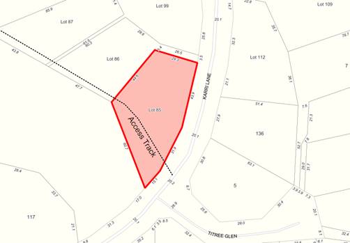
The applicant is proposing a three bedroom, two bathroom dwelling with an open plan living area, alfresco and porch. If approved the dwelling will be constructed of cement fibre sheet cladding with a Colorbond® skillion roof. A copy of the plans for the development, aerial and site photographs are attached.
ATTACHMENT: 9.5.6(1)
A site inspection undertaken 27 May 2022 identified that clearing had been undertaken and although it is uncertain as to the extent of the clearing on comparison of the aerial and the site plan provided, clearing has occurred outside of the building envelope.
Council is requested to consider the application as Shire Officers do not have the delegation to determine development applications which are retrospective in nature.
PUBLIC Consultation Undertaken:
The application was referred to the adjoining neighbours for comment for a period of 21 days and to the Department of Water and Environmental Regulation (DWER) for a 42 Day period.
Water Corporation advised that the proposed development does not appear to affect assets held by the Water Corporation and that builders should seek its approval prior to commencing works in relation to water service connection. DWER provided advice in relation to the clearing and on site effluent disposal.
A late submission was also received from an adjacent landowner raising concerns regarding the overall amount of clearing that is occurring within the Karri Lakes estate.
The comments are discussed below in detail and a copy of the submissions are attached.
ATTACHMENT: 9.5.6(2)
COMMENT (Includes Options):
The provisions of the Shire of Manjimup’s Local Planning Scheme No. 4 (the Scheme) include the subject land within the Residential zone. The Scheme maps apply a maximum density of R2.5, being a minimum lot size of 4,000m² in accordance with the Residential Design Codes of Western Australia (R-Codes).
Clause 10.2 of the Scheme prescribes that in determining applications for planning approval, the local government must have regard to various matters. Relevant considerations for the subject application are as follows:
(vii) the content and objective of Planning Precinct Statements set out in Schedule 8 of this Scheme;
(x) The compatibility of a use or development with its setting including the potential impact on the use and enjoyment of adjacent and nearby land and taking into consideration any Special Control Area;
(xiv) whether the land to the application relates is unsuitable for the proposal by reason of it being, or likely to be, subject to flooding, tidal inundation, subsidence, landslip, bush fire or any other risk;
(xv) the preservation of the amenity of the locality; and
(xvi) the relationship of the proposal to development on adjoining land or on other land in the locality including but not limited to, the likely effect of the height, bulk, scale, orientation and appearance of the proposal.
To assist Council in determining the application, the following comments are offered:
Scheme Objectives
The application as submitted is consistent with the objectives of the Residential zone as it provides a residential dwelling for the landowner.
Residential Design Codes
The proposed Dwelling – Single complies with the provisions of the R-Codes.
Planning Precinct Requirements
The Planning Precinct Statement relating to the Quinninup Karri Lakes development provides for building envelopes and exclusion areas. The applicable building envelope for the subject land is identified on the approved structure plan with the following setbacks:
a) Front – 12 metres
b) Sides – 8-12 metres
c) Rear – 12 metres
The proposed dwelling complies with the above setbacks and therefore the approved building envelope.
As outlined by Schedule 8 – clause 5.3.2 of the Scheme “A landowner may clear up to 800m² of the live standing native trees within the approved building envelope or area permitted for development on the lot with other clearing to provide for vehicular access to the road system and requirements for fire control to the satisfaction of the local government.” Further comments with respect to the clearing undertaken are provided under the heading Unauthorised Clearing overleaf.
In addition to the above, the special provisions outlined within Schedule 8 - clause 5.3.7 outline specific requirements relating to effluent disposal systems within the estate, requiring that each system is installed to ensure:
a) A minimum of 2 metres vertical separation between the base of the leach drain and the highest known ground water or bedrock; and
b) A minimum of 60 metres horizontal clearance between the system and the edge of the lake or streams contained in the open space areas.
State Planning Policy No 3.7 (SPP No 3.7)
This policy outlines land use planning considerations in respect of bushfire risk management in Western Australia. Bushfire Prone mapping provided by the Department of Fire and Emergency Services indicates that whole of the Karri Lakes Estate, including the subject land, is bushfire prone.
In accordance with clause 6.5 of SPP No 3.7, applications for development within bushfire prone areas are to be accompanied by:
a) an assessment of the Bushfire Attack Level (BAL); and
b) a Bushfire Management Plan (BMP) demonstrating compliance with the bushfire protection requirements.
In this case, the applicant has submitted a BAL report demonstrating that having regard to the clearing undertaken a BAL 40 rating has been achieved for the proposed dwelling. Whilst a BMP has not been submitted, the provisions of the Shire’s annual firebreak notice negate the requirement for a BMP in terms of vegetation management.
Annual Firebreak Notice
In accordance with the Shire’s Annual Firebreak and Hazard Notice, a “Building Protection Zone” is required to be established and maintained for a minimum of 20 metres, measured from any external wall of a dwelling. Within this area owners are required to:
· Remove all flammable material within 20 metres of any dwelling or outbuilding;
· Ensure no trees over hanging the dwelling, no shrub or live standing tree is located within 2 metres and tree trunks are free of branches to a height of 2 metres; and
· Ensure shrubs are not located under trees, nor planted in clumps greater than 5m², with clumps separated by 5 metres.
The submitted BAL demonstrates that ongoing compliance with the annual firebreak notice will ensure that the identified BAL rating will be maintained.
Unauthorised Clearing
In terms of the clearing undertaken without prior planning approval, it is noted that:
a) The landowners are not proposing to clear more of the property to achieve a lesser BAL rating;
b) The vegetated area cleared, which is outside of the building envelope, is downslope from the proposed development and would have been a high bushfire hazard risk;
c) Once the home is approved and constructed a 20 metre asset protection zone will be required under the Bush Fires Act 1954 and Shire’s Fire and Fuel Hazard Reduction Notice; and
d) Shire Officers have not been able to determine the number of live standing trees that have been removed.
Notwithstanding the above, clearing has been undertaken outside of the building envelope, without prior approval. This is a clear contravention of the Scheme requirements and the owners have been issued a modified penalty for the unauthorised clearing.
In addition to the modified penalty it is recommended that the landowner be required to undertake revegetation works for those areas outside of the identified asset protection area.
DWER Submission
The comments received from DWER covered vegetation clearing and on site effluent disposal.
Clearing
DWER advised that in accordance with the Environmental Protection Act 1986 (EP Act) development approval should be obtained prior to clearing, to ensure the clearing meets the exemptions under the EP Act. It has also advised that the proposal is subject to the Country Areas Water Supply Act 1947 (CAWS Act) where clearing restrictions apply and a licence to clear is required.
It is recommended that the applicant be advised to contact the DWER with regards to the requirements for Clearing Permits and Licenses.
On-site Waste Water Disposal
DWER has advised that there should be adequate separation distance from onsite effluent disposal to the Quinninup Dam which has recently been de-proclaimed as a drinking water source, enabling recreational uses. It also has previously advised the Shire to consider the cumulative impacts from the adjacent on-site sewage disposal systems. The applicant has not provided details on the location of the effluent disposal system as part of this application. It is recommended that the provisions of the Scheme in regards to separation distances be reiterated as part of conditions of any approval.
Whilst the comments received from DWER in respect of the clearing restrictions are noted and appropriate advice notes are required, the comments provided in respect of on-site waste water disposal are un-necessary. The approval of effluent disposal systems is the responsibility of the local government and Shire Officers are fully aware of the requirements outlined under Schedule 8 of the Scheme relating to effluent disposal systems within the Karri Lake Estate.
Conclusion
The proposed Dwelling-Single complies with the Scheme and R-Codes requirements, with the exception that clearing has occurred outside of the approved building envelope, without the required prior planning approval.
As it is difficult to determine the number of live standing trees that have been removed, legal action would not be straight forward. As a result, a modified penalty has been issued. Notwithstanding this, in order to mitigate the visual impact of the clearing, revegetation of that area outside of the asset protection zone is recommended.
STATUTORY ENVIRONMENT:
Planning and Development Act 2005.
Policy / Strategic Implications:
The proposal and retrospective clearing application has been assessed against the following Strategies contained within the Strategic Community Plan 2021-2031:
A5. Manage fuel hazards to minimise the risk of serious fire threat to ecosystems, human life and property.
A6. Manage natural waterways and lakes to encourage water flow and catchments for self-sustaining purposes.
A8. Effectively use development and land policies to protect and rehabilitate the environment whilst balancing the needs of the community.
A11. Support initiatives to curtail or prosecute littering, pollution and unauthorised clearing of vegetation.
C13. Plan for emergency and natural disaster response, management, evacuation and recovery.
C15. Manage environmental health risks in the community.
Organisational risk management:
Unless the landowner is required to complete rehabilitation works, there is risk that the amenity of the adjacent properties will be detrimentally impacted.
Financial Implications:
The required application fee for the Dwelling-Single has been paid.
Sustainability:
Environmental: The clearing that has been undertaken may require additional permits and licenses from DWER.
Economic: Nil.
Social: The existing vegetation within the Karri Lake Estate is a key element in respect of the areas amenity and the removal of vegetation should be managed so as not to detrimentally
VOTING REQUIREMENTS: SIMPLE MAJORITY
|
That: 1. Council in accordance with Clause 5.5, Clause 8.6 and Part 10 of the Shire of Manjimup Local Planning Scheme No. 4 grants retrospective planning approval for Land Clearing outside of the building envelope and approval to a Dwelling – Single at Lot 85 Karri Lane, Quinninup (Application TP75/2022) as outlined in the plans and specifications attached at and subject to the following conditions: a) The development permitted shall be carried out generally in accordance with the plans and specifications submitted as listed below:
b) Prior to the occupation of the development, a vehicle crossover between the subject land and Karri Lane is to be located, designed, constructed, sealed and drained to the specification and satisfaction of the Shire of Manjimup. c) All stormwater and drainage runoff is to be retained on the subject property or to be provided with stormwater drainage connections to the drainage system in the area at the developers cost to the satisfaction to the Shire of Manjimup. d) Prior to the use or occupation of the development, the Asset Protection Zone (APZ) must be established and the property thereafter maintained in accordance with the Bushfire Management Plan as approved by the Shire of Manjimup. e) All habitable buildings are to be constructed in accordance with the Australian Standard 3959 “Construction of Buildings in Bushfire Prone Areas” to the satisfaction of the Shire of Manjimup. f) The applicant shall within 90 days of this approval submit detailed plans to the satisfaction of the Chief Executive Officer detailing the revegetation works to be undertaken outside of the Asset Protection Zone. The use of low fire threat vegetation is encouraged. g) Conventional on-site effluent disposal systems must be located and installed such that there is at least: i. a minimum of a 2 metre vertical separation between the base of the leach drain and the highest known groundwater level or bedrock; and ii. a minimum of a 60 metre horizontal separation between the effluent disposal system and the edge of the lake or the streams contained within the open space areas. Advice to Applicant i. This Development approval is NOT a building permit. A building permit must be formally applied for and obtained from Building Services BEFORE the commencement of any site and/or development works. ii. Where clearing of land is involved in any proposed development, the approval of the Department of Water and Environmental Regulation will be required under the provisions of the Environmental Protection Act 1986 and Country Areas Water Supply Act 1947. iii. No clearing of trees or vegetation is permitted in the Public Reserve adjacent to the application site without the prior approval of Shire of Manjimup. iv. The development the subject of this planning approval, must comply with the requirements of the Health (Miscellaneous Provisions) Act 1911 and the Shire of Manjimup’s Health Local Laws 2020. v. Prior to commencing development, an application to construct or install an apparatus for the treatment of sewage and the disposal of effluent and liquid wastes must be submitted for the approval of the Shire of Manjimup’s Environmental Health Team, in accordance with the Health (Treatment of Sewage and Disposal of Effluent and Liquid Waste) Regulations 1974. 2. The Department of Water and Environmental Regulation be advised that further comments are not required in respect of the Shire’s role in approving on-site effluent disposal systems within the Karri Lake Estate, with the provisions of Schedule 8 of the Shire’s Local Planning Scheme No 4 outlining clear separation requirements which will be enforced by the Shire as the local authority responsible for these approvals. |
|
ATTACHMENTS |
||
|
1⇨ |
Attachment 1 - Plans of Development and Site Information |
8 Pages |
|
2⇨ |
Attachment 2 - Submissions Recieved |
4 Pages |
71
9.5.7 Proposed Dwelling - Single and Retrospective Land Clearing at Lot 28 Karri Lane, Quinninup
|
PROPONENT |
Mr R M Donald |
|
OWNER |
Mr D L & Ms L J Donald & Mr R M Donald |
|
LOCATION / ADDRESS: |
Lot 28 Karri Lane, Quinninup |
|
WARD: |
East |
|
ZONE: |
Residential |
|
DIRECTORATE: |
Development and Regulation |
|
FILE REFERENCE: |
DA22/58 P51194 |
|
LEGISLATION: |
Planning and Development Act 2005 |
|
AUTHOR: |
Jocelyn Baister/Brian Robinson |
|
DATE OF REPORT: |
12 July 2022 |
|
DECLARATION OF INTEREST: |
Nil |
Background:
Council is requested to consider an application for a Dwelling – Single, Building Envelope variation and retrospective land clearing outside of a building envelope. The subject property is 3,444m² and is located to the western side of Quinninup Dam in the Karri Lakes estate. There is a strategic firebreak along the rear boundary which separates the property from the adjoining National Park. A location plan is provided below.
LOCATION PLAN

The applicant is proposing a four bedroom, two bathroom dwelling with open plan living area, front and rear verandahs. If approved the dwelling will be constructed of horizontal cladding and corrugated roof sheeting in Colorbond® Monument colour. A copy of the plans for the development, aerial and site photographs are attached.
ATTACHMENT: 9.5.7 (1)
In support of the application, the applicant supplied a Bushfire Attack Level (BAL) report which excluded some vegetation. When requested to provide a proposed clearing plan, the applicant advised that the clearing had already been undertaken. As a result site inspection was undertaken 27 May 2022, confirmed this. Although it is uncertain as to the extent of the clearing on comparison of the aerial and the site plan provided, clearing has occurred outside of the building envelope.
Council is requested to consider the application as Shire Officers do not have the delegation to determine development applications which are retrospective in nature.
PUBLIC Consultation Undertaken:
The application was referred to the adjoining neighbours for comment for a period of 21 days and to the Department of Water and Environmental Regulation (DWER) and the Department of Biodiversity Conservation and Attractions (DBCA) for a 42 Day period. At the close of advertising, comments were received from DBCA and DWER. No comments were received from neighbouring landowners.
The comments received are attached, with their content discussed within the Comment section below.
ATTACHMENT: 9.5.7 (2)
COMMENT (Includes Options):
The provisions of the Shire of Manjimup’s Local Planning Scheme No. 4 (the Scheme) include the subject land within the Residential zone. The Scheme maps apply a maximum density of R2.5, being a minimum lot size of 4,000m² in accordance with the Residential Design Codes of Western Australia (R-Codes).
Clause 10.2 of the Scheme prescribes that in determining applications for planning approval, the local government must have regard to various matters. Relevant considerations for the subject application are as follows:
(vii) the content and objective of Planning Precinct Statements set out in Schedule 8 of this Scheme;
(x) The compatibility of a use or development with its setting including the potential impact on the use and enjoyment of adjacent and nearby land and taking into consideration any Special Control Area;
(xiv) whether the land to the application relates is unsuitable for the proposal by reason of it being, or likely to be, subject to flooding, tidal inundation, subsidence, landslip, bush fire or any other risk;
(xv) the preservation of the amenity of the locality; and
(xvi) the relationship of the proposal to development on adjoining land or on other land in the locality including but not limited to, the likely effect of the height, bulk, scale, orientation and appearance of the proposal.
To assist Council in determining the application, the following comments are offered:
Scheme Objectives
The application as submitted is consistent with the objectives of the Residential zone as it provides a residential dwelling for the landowner.
Planning Precinct - Building Envelopes
The Quinninup Karri Lakes development has a Planning Precinct Statement, which provides for building envelopes and exclusion areas. The applicable building envelope is identified on the approved structure plan with the following setbacks:
a) Front – 10 metres
b) Sides – 10 metres
c) Rear – 35 metres
The Dwelling as proposed is located within the approved building envelope.
As outlined by Schedule 8 – clause 5.3.2 of the Scheme “A landowner may clear up to 800m² of the live standing native trees within the approved building envelope or area permitted for development on the lot with other clearing to provide for vehicular access to the road system and requirements for fire control to the satisfaction of the local government.” In this case, whilst clearing has occurred outside of the building envelope without prior approval, it is noted that the approved building envelope has an area of approximately 520m², substantially less than 800m².
In addition to the above, the special provisions outlined within Schedule 8 - clause 5.3.7 outline specific requirements relating to effluent disposal systems within the estate, requiring that each system is installed to ensure:
a) A minimum of 2 metres vertical separation between the base of the leach drain and the highest known ground water or bedrock; and
b) A minimum of 60 metres horizontal clearance between the system and the edge of the lake or streams contained in the open space areas.
State Planning Policy No 3.7 (SPP No 3.7)
This policy outlines land use planning considerations in respect of bushfire risk management in Western Australia. Bushfire Prone mapping provided by the Department of Fire and Emergency Services indicates that whole of the Karri Lakes Estate, including the subject land, is bushfire prone.
In accordance with clause 6.5 of SPP No 3.7, applications for development within bushfire prone areas are to be accompanied by:
a) an assessment of the Bushfire Attack Level (BAL); and
b) a Bushfire Management Plan (BMP) demonstrating compliance with the bushfire protection requirements.
In this case, the applicant has submitted a BAL report stating an achieved BAL 40, after the clearing was undertaken. It is noted that the BAL report and clearing site plan does not address the need to contain the APZ within the property. However it is also noted that the alternative orientation of the proposed Dwelling on the property would still not achieve an APZ as the property is not wide enough to accommodate both.
Whilst a BMP has not been submitted, the provisions of the Shire’s annual firebreak notice negate the requirement for a BMP in terms of vegetation management.
Annual Firebreak Notice
In accordance with the Shire’s Annual Firebreak and Hazard Notice, a “Building Protection Zone is required to be established and maintained for a minimum of 20 metres, measured from any external wall of a dwelling. Within this area owners are required to:
· Remove all flammable material within 20 metres of any dwelling or outbuilding;
· Ensure no trees over hand the dwelling, no shrub or live standing tree is located within 2 metres and tree trunks are free of branches to a height of 2 metres; and
· Ensure shrubs are not located under trees, nor planed in clumps greater than 5m², with clumps separated by 5 metres.
The submitted BAL demonstrate that ongoing compliance with the annual firebreak notice will ensure that the identified BAL rating will be maintained.
Unauthorised Clearing
The applicant has cleared approximately 710m² of vegetation for building site and BAL reduction. This includes live standing trees and under storey vegetation outside of the approved building envelope.
The vegetated area cleared, which is outside of the building envelope, is both upslope and at grade from the proposed development and would have been a high bushfire hazard risk. However the clearing has occurred without the prior approval in direct contravention of the Scheme requirements. For this reason, the owners have been issued a modified penalty.
While the applicant has retained an area of vegetation to the front of the building envelope and only undertaken ‘parkland clearing’ to the APZ, there is the ability for some revegetation works to be undertaken in a manner that is consistent with the requirements of the Shire’s Annual Firebreak and Hazard Reduction Notice. It is therefore recommended that appropriate conditions be imposed relating to the owners completing some revegetation of the area cleared to the satisfaction of the Shire.
It is also recommended that the applicant be advised to contact the Department of Water and Environmental Regulation with regards to the requirements for Clearing Permits.
Residential Design Codes
The proposed Dwelling – Single meets the provisions of the R-Codes.
Comments from DWER
The comments received from DWER related to vegetation clearing and on site effluent disposal as outlined overleaf.
Clearing
DWER advised that in accordance with the Environmental Protection Act 1986 (EP Act) development approval should be obtained prior to clearing, to ensure the clearing meets the exemptions under the EP Act. It has also advised that the proposal is subject to the Country Areas Water Supply Act 1947 (CAWS Act) where clearing restrictions apply and a licence to clear is required.
On-site Waste Water Disposal
DWER has advised that there should be adequate separation distance from onsite effluent disposal to the Quinninup Dam which has recently be de-proclaimed as a drinking water source, enabling recreational uses. It also has previously advised the Shire to consider the cumulative impacts from the adjacent on-site sewage disposal systems. The applicant has not provided details on the location of the effluent disposal system as part of this application. It is recommended that the provisions of the Scheme in regards to separation distances be reiterated as part of conditions of any approval.
Given that the property is located on the south side of Karri Lane, more than 150 metres from the lake, the comments relating to effluent disposal are not relevant to the application. Nowithstanding this, comments relating to the approval of effluent disposal systems was not required and is the responsibility of the local government. Shire Officers are fully aware of the requirements outlined under Schedule 8 of the Scheme relating to effluent disposal systems within the Karri Lake Estate.
Comments from DBCA
DBCA have advised that “all fire protection requirements, including firebreaks to shire guidelines, water supply and hazard separation zones should be provided for on the property itself and there should be no expectation that any fire protection measures will be provided for the proponent on the adjacent department-managed lands.” The Department also outlines that it expects that the dwelling will be constructed and situated as per requirements in the Guidelines for Planning in Bushfire Prone Areas.
Conclusion
The proposed Dwelling- Single complies with the Scheme and R-Codes requirements. It has been found that clearing has been undertaken outside of a prescribed building envelope which required prior planning approval. Additional revegetation of the area outside of the asset protection zone is recommended to compensate for that already cleared prior to approval being granted.
STATUTORY ENVIRONMENT:
Planning and Development Act 2005 and Local Planning Scheme No. 4
Policy / Strategic Implications:
The proposal and retrospective clearing application has been assessed against the following Strategies contained within the Strategic Community Plan 2021-2031:
A5. Manage fuel hazards to minimise the risk of serious fire threat to ecosystems, human life and property.
A8. Effectively use development and land policies to protect and rehabilitate the environment whilst balancing the needs of the community.
A11. Support initiatives to curtail or prosecute littering, pollution and unauthorised clearing of vegetation.
C15. Manage environmental health risks in the community.
Organisational risk management:
Nil.
Financial Implications:
The required application fee has been paid by the applicant.
Sustainability:
Environmental: The proposed land clearing will be assessed by the Department of Water and Environmental Regulation for significant environmental impacts.
Economic: Nil.
Social: Nil.
VOTING REQUIREMENTS: SIMPLE MAJORITY
|
That Council in accordance with Clause 5.5, Clause 8.6 and Part 10 of the Shire of Manjimup Local Planning Scheme No. 4 grants retrospective planning approval for Land Clearing outside of the building envelope and approval to a Dwelling – Single at Lot 28 Karri Lane, Quinninup (Application TP63/2022) as outlined in the plans and specifications attached at 9.5.7(1) and subject to the following conditions: 1. The development permitted shall be carried out generally in accordance with the plans and specifications submitted as listed below:
2. Prior to the occupation of the development, a vehicle crossover between the subject land and Karri Lane is to be located, designed, constructed, sealed and drained to the specification and satisfaction of the Shire of Manjimup. 3. All stormwater and drainage runoff is to be retained on the subject property or to be provided with stormwater drainage connections to the drainage system in the area at the developers cost to the satisfaction to the Shire of Manjimup. 4. Prior to the use or occupation of the development, the Asset Protection Zone (APZ) must be established and the property thereafter maintained in accordance with the Bushfire Management Plan as approved by the Shire of Manjimup. 5. All habitable buildings are to be constructed in accordance with the Australian Standard 3959 “Construction of Buildings in Bushfire Prone Areas” to the satisfaction of the Shire of Manjimup. 6. The applicant shall within 90 days of this approval submit detailed plans to the satisfaction of the Chief Executive Officer detailing the revegetation works to be undertaken outside of the Asset Protection Zone. The use of low fire threat vegetation is encouraged. 7. Conventional on-site effluent disposal systems must be located and installed such that there is at least a minimum of a 2 metre vertical separation between the base of the leach drain and the highest known groundwater level or bedrock. Advice to Applicant i. This Development approval is NOT a building permit. A building permit must be formally applied for and obtained from Building Services BEFORE the commencement of any site and/or development works. ii. The Department of Water and Environmental Regulation must be contacted with regard to the clearing undertaken given the need for approval to be obtained in accordance with the provisions of the Environmental Protection Act 1986 and Country Areas Water Supply Act 1947. iii. The development the subject of this planning approval, must comply with the requirements of the Health (Miscellaneous Provisions) Act 1911 and the Shire of Manjimup’s Health Local Laws 2020. iv. Prior to commencing development, an application to construct or install an apparatus for the treatment of sewage and the disposal of effluent and liquid wastes must be submitted for the approval of the Shire of Manjimup’s Environmental Health Team, in accordance with the Health (Treatment of Sewage and Disposal of Effluent and Liquid Waste) Regulations 1974. |
|||||||||||||||
|
|
|
ATTACHMENTS |
||
|
1⇨ |
Attachment 1 - Development Plans, Aerial and Site Photographs |
10 Pages |
|
2⇨ |
Copy of Advice Received - DWER and DBCA |
7 Pages |
73
9.5.8 Quarterly Report - April to June 2022 - Director of Development and Regulation
|
PROPONENT |
Director of Development and Regulation |
|
OWNER |
N/A |
|
LOCATION / ADDRESS: |
Whole of Shire |
|
WARD: |
All |
|
ZONE: |
N/A |
|
DIRECTORATE: |
Development and Regulation |
|
FILE REFERENCE: |
F160966 |
|
LEGISLATION: |
Various |
|
AUTHOR: |
Brian Robinson |
|
DATE OF REPORT: |
12 July 2022 |
|
DECLARATION OF INTEREST: |
Nil |
Background:
A report outlining the activities of the Development and Regulation Directorate is attached for the period of April to June 2022 for Councillors information and reference.
ATTACHMENT: 9.5.8 (1)
PUBLIC Consultation Undertaken:
Nil.
COMMENT (Includes Options):
The purpose of this agenda item is to inform Councillors of activities undertaken and to provide Councillors with an opportunity to raise queries in respect of those activities.
STATUTORY ENVIRONMENT:
Various legislation as applicable to the activities undertaken within the Development and Regulation Directorate.
Policy / Strategic Implications:
Nil.
Organisational risk management:
Nil.
Financial Implications:
All activities were undertaken in accordance with the Shire of Manjimup’s 2021/22 Annual Budget.
Sustainability:
Environmental: As stated in Attachment.
Economic: As stated in Attachment.
Social: As stated in Attachment.
VOTING REQUIREMENTS: SIMPLE MAJORITY
|
That Council receive the April to June 2022 Quarterly Report for the Development and Regulation Directorate as contained in Attachment: 9.5.8(1). |
|
ATTACHMENTS |
||
|
1⇨ |
Attachment No 1 - Quarterly Report |
29 Pages |
76
9.5.9 Delegated Planning Decisions for June 2022
|
PROPONENT |
Shire of Manjimup |
|
OWNER |
Various |
|
LOCATION / ADDRESS: |
Various |
|
WARD: |
Various |
|
ZONE: |
Various |
|
DIRECTORATE: |
Development and Regulation |
|
FILE REFERENCE: |
F170085 |
|
LEGISLATION: |
Planning and Development Act 2005 Local Government Act 1995 |
|
AUTHOR: |
Kaylee Blee |
|
DATE OF REPORT: |
14 July 2022 |
|
DECLARATION OF INTEREST: |
Nil |
Background:
In order to ensure the efficient and timely processing of planning related applications, Council delegates authority to the Chief Executive Officer to conditionally approve Applications for Development Approval that meet the requirements of both Local Planning Scheme No 4 (the Scheme) and adopted Planning Policy.
Delegated planning decisions are reported to Council on a monthly basis to ensure that Council has an appropriate level of oversight on the use of this delegation. A Register of Delegated Development Approvals, detailing those decisions made under delegated authority in June 2022 is attached.
ATTACHMENT: 9.5.9 (1)
PUBLIC Consultation Undertaken:
Where required applications were advertised in accordance with the Scheme and Council’s adopted Local Planning Policy as detailed in the Policy/Strategic Implications section below.
COMMENT (Includes Options):
During June 2022, fifteen (15) development applications were determined under delegated authority. Table 1 shows the number and value of development applications determined under both delegated authority and by Council for June 2022 compared to June 2021:
Table 1: Planning Decisions Made June 2021 and 2022
|
|
June 2021 |
June 2022 |
|
Delegated Decisions |
5 ($288,500) |
15 ($471,750) |
|
Council Decisions |
3 ($123,000) |
3 ($73,000) |
|
Total |
8 ($411,500) |
18 ($544,750) |
Table 2 compares the Year-To-Date statistics for delegated authority and Council decisions for 2021-22 compared to the previous Financial Year:
Table 2: Planning Decisions Made Year-To-Date 2020-21 and 2021-22
|
|
YTD 2020-21 |
YTD 2021-22 |
|
Delegated Decisions |
137 ($12,621,543) |
119 ($11,207,226) |
|
Council Decisions |
53 ($14,803,400) |
52 ($10,924,688) |
|
Total |
190 ($27,424,943) |
171 ($22,131,914) |
STATUTORY ENVIRONMENT:
The Scheme is a Local Planning Scheme, made in accordance with the Planning and Development Act 2005 and associated regulations. Part 8 of the Scheme states that prior planning approval is required for all developments (including land use), except those developments identified within Part 8.4 as being Permitted Development.
In accordance with Part 11.3 of the Scheme, Council has delegated a number of planning powers to the Chief Executive Officer. These powers have been on-delegated by the Chief Executive Officer to other staff in accordance with clause 11.3.3 of Local Planning Scheme No 4.
Clause 11.3.5 of the Scheme requires that a delegation under the Scheme is consistent with sections 5.45 and 5.46 of the Local Government Act 1995 and the regulations referred to in clause 5.46 of that Act. Regulation 19 of the Local Government (Administration) Regulations 1996 requires that a written record of each delegated decision be kept.
Policy / Strategic Implications:
Applications for Development Approval must be assessed against requirements of the Scheme and Local Planning Policies that have been adopted in accordance with Part 2 of the Scheme. These Policies include Local Planning Policy LPS4 6.1.2 Advertising of Planning Proposals, which details the level and scope of advertising required for Applications for Development Approval.
Each application processed under delegated authority has been processed and advertised, where required, and has been determined to be consistent with the requirements of all adopted Local Planning Policies.
Organisational risk management:
Nil.
Financial Implications:
The required planning fees have been paid for all applications for Development Approval processed under delegated authority.
Sustainability:
Environmental: Nil.
Economic: Nil.
Social: Nil.
VOTING REQUIREMENTS: SIMPLE MAJORITY
|
That Council receives the report on Delegated Development Approvals for June 2022 as per Attachment: 9.5.9(1).
|
|
ATTACHMENTS |
||
|
1⇨ |
Development Decisions - June 2022 |
1 Page |
83
9.5.10 Proposed Dwelling - No 3 (Lot 160) Merlot Street, Walpole
|
PROPONENT |
Milford Homes Pty Ltd |
|
OWNER |
N & K Haywood |
|
LOCATION / ADDRESS: |
No 3 (Lot 160) Merlot Street, Walpole |
|
WARD: |
South |
|
ZONE: |
Residential (R10) |
|
DIRECTORATE: |
Development & Regulation |
|
FILE REFERENCE: |
DA22/100 |
|
LEGISLATION: |
Planning and Development Act 2005 |
|
AUTHOR: |
Brian Robinson |
|
DATE OF REPORT: |
15 July 2022 |
|
DECLARATION OF INTEREST: |
Nil |
Background:
The subject land is a residential lot located on the northern side of Merlot Street within the Boronia Ridge Estate, Walpole. With an area of 1,081m² the property is currently vacant. As shown on location plan below, an easement relating to the reticulated sewerage service is located along the rear boundary.
Location Plan
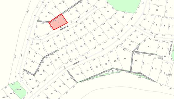
Approval is being sought to the establishment of a timber framed/stump construction 3 bedroom, two bathroom home, with a double carport on the eastern side and timber decking on the remaining three sides. Copies of the submitted site and floor plans together with the proposed elevations are shown attached.
ATTACHMENT: 9.5.10(1)
The proposal seeks to vary the approved building envelope to the front and eastern side boundaries. A variation is also sought in respect of the requirements of the Residential Design Codes relating to visual privacy. Council is requested to determine the application as an objection has been received to the variation of the building envelope.
PUBLIC Consultation Undertaken:
Given the proposed variation of the building envelope and variation of the R-Code requirements, the proposal was referred to the adjacent landowners for comment. At the close of advertising a single very brief submission was received objecting to the variation of the building envelope. A copy of the submission is shown attached.
ATTACHMENT: 9.5.10(2)
COMMENT (Includes Options):
The provisions of Local Planning Scheme No 4 (the Scheme) include the subject land within the Residential Zone, with an applicable density of R10 in accordance with the Residential Design Codes of Western Australia (the R-Codes). In addition the Scheme includes the Boronia Ridge Estate, in which the land is located, within Planning Precinct WP 1.
In determining applications for Development Approval, clause 10.2 of the Scheme requires that the local government has due regard to various matters. Matters relevant to the current application are:
(i) The aims and provisions of the Scheme and any other relevant Local Planning Scheme operating within the Scheme area;
(iii) Any approved State Planning Policies of the Commission;
(vi) The contact and objective of Planning Precinct Statements set out in Schedule 8 of this Scheme;
(x) the compatibility of a use or development with its setting including the potential impact on the use and enjoyment of adjacent and nearby land and taking into consideration any Special Conttol Area;
(xi) the preservation of the amenity of the locality;
(xvi) the relationship of the proposal to development on adjoining land or on other land in the locality including but not limit to, the likely effect of the height, bulk, sale, orientation and appearance of the proposal;
(xxviii) any relevant submissions received on the application.
To assist Council in determining the application, having regard to the above matters, the following comments are offered:
Planning Precinct WP. 1
As detailed above, the Scheme includes the subject land within Planning Precinct WP. 1. In accordance with Precinct WP. 1 - clause (ix) dwellings and other buildings are required to comply with the building envelope as shown on the endorsed structure plan.
Clause (ix) outlines that “The local government may, at the request of the landowner, vary the position, shape or size of a building envelope where it is of the opinion that the slope, vegetation or site conditions justify a variation. Building envelopes shall be sized to maximise the retention of native vegetation.” An assessment of the proposal to vary the building envelope is provided below.
In addition to the above, the Scheme provisions relating to Planning Precinct WP 1 outline a number of other requirements relating to the retention of vegetation and building materials. Further detailed guidelines relating to building design is contained within Local Planning Policy No 6.1.15 (LPP 6.1.15). An assessment of the proposal against LPP No 6.1.15 is provided below.
Variation of Building Envelope
The approved Structure Plan identifies that the approved building envelope for the subject land is setback as follows:
Front: 7.5 metres
Rear: 6.0 metres
Western Side Boundary: 7.4 metres
Eastern Side Boundary: 7.4 metres
The application proposes the establishment of a dwelling with the carport being setback 1.5 metres from the eastern side boundary, equating to a relaxation of 5.9 metres and a front verandah 6.5 metres from the front boundary, being a relaxation of 1 metre.
As reflected above, clause (ix) states that the building envelope may be varied where the slope, vegetation or site conditions justify a variation. In this case, the proposed variation to the side setback will not result in the preservation of vegetation and the site conditions do not appear to justify the variation as proposed. That said, an increase in the proposed setbacks will result in the rear deck being located closer to the rear boundary, exacerbating potential overlooking issues. Further assessment of the proposed side setback is provided in the balance of this agenda item.
In terms of the variation of the building envelope setback to the front boundary, the variation is considered minor and will permit the construction of a front deck, adding to the aesthetics of the home as viewed from the street. Given this and the fact no objections were raised with respect to the proposed front setback, this aspect of the proposal is supported.
LPP No 6.1.15
The purpose of LPP No 6.1.15 is to prescribe the minimum standards applicable to residential development within the Boronia Ridge Estate. The Policy prescribes requirements relating to roof eaves, roof and wall colours and fencing. As an assessment of the proposal against the Policy requirements has identified that:
a) The application complies with the requirements relating to design and eaves;
b) Whilst the use of colourbond products is proposed for both the roof and wall cladding, no details have been provided in respect of the colours to be used.
It is recommended that an appropriate condition should be imposed on any approval granted to ensure compliance with the requirements of LPP No 6.1.15 in respect of wall and roof colours and to ensure that zincalume is not utilised.
R-Code Requirements
In addition to the building envelope applied by the Scheme, development must comply with the Residential Design Codes of WA. An assessment against the requirements of the R-Codes has identified an issue relating to the potential for overlooking associated with the rear deck.
In order to meet the Deemed-to-comply provisions of the R-Codes, unenclosed outdoor active habitable spaces such as raised decks must be setback a minimum of 7.5m from a boundary. Alternatively, they must be provided with permanent screening to restrict views within the cone of vision. In this case, the submitted plans detail that the rear verandah will be:
a) Up to 1.9 metres above the natural ground level; and
b) Will be setback as close as 6.2 metres to the rear boundary.
Whilst the rear setback as proposed will ensure the building is compliant with the rear setback to the building envelope, given the slope of the land, the height or the rear deck will be well above the height of any standard fencing to be erected along the rear boundary. In order to minimise the potential for overlooking, it is recommended that the design be modified or appropriate methods to screen the deck should be considered.
If the proposed carport is required to be setback in accordance with the approved building envelope setback of 7.4 metres, the rear of the dwelling will effectively be pushed closer to the rear boundary, further exacerbating the potential for overlooking.
Precedence for Building Envelope Variation
Examination of aerial photography and Shire records indicates that numerous approvals have been granted to Building Envelope variations, effectively reducing side setbacks. The following examples are provided relating to other properties in Merlot Street:
1. Lot 158 Merlot Street (two properties north) which had a building envelope setback of 7.7. metres to the side boundaries. Development has been approved as follows:
a) The proposed dwelling was approved in 2014 with a 5.1 metre rather than 7.7 metre setback to the eastern side boundary. Approval was granted under delegated authority following advertising and no submissions being received; and
b) A garage was approved in 2019 with a setback of 3 metres to the western side boundary rather than the identified setback of 7.7 metres. This application was also approved under delegated authority as a result of no submissions received.
2. Lot 151 Merlot Street (opposite the subject land) which had a building envelope setback 5 metres to the western boundary and 6 metres to the eastern boundary. A dwelling was approved with setbacks of 3 metres to the western and 3.29 metres to the eastern side boundaries.
Given the above, it is considered that a precedent has been set in the immediate area for a minimum side setback of 3 metres.
Neighbour Comments
As reflected within the Public Consultation Section of this item, the adjacent landowner to the east has lodged a very brief submission in objection to the proposed setback stating that “I don’t agree with this proposal as I can’t see any reason not to maintain the 5 meter clearance from the fence line.”
Whilst the author of the submission has not provided any specific planning grounds supporting their position, a relaxation of the setback as proposed may detrimentally impact on the amenity of their property.
Conclusion
As detailed above, the applicants are seeking a minor variation to the front setback, to which no objection has been received. This aspect of the proposal is supported.
In terms of the proposed setback of 1.5 metres to the carport, it is recommended that this be increased to a minimum of 3 metres on the basis that:
a) A 3 metre distance would be consistent with other building envelope variations that have been granted in the immediate area;
b) There is sufficient room to accommodate a setback given that the submitted plans demonstrate that the dwelling if approved will be setback more than 15 metres from the western side boundary; and
c) The potential for overlooking from the rear deck will not be greatly increased by an increase of the side setback by 1.5 metres.
Should approval to the application be granted, it is recommended that screening of the rear deck be required in accordance with the R-Codes. Screening to a height of 1.6 metres for that extent of the deck that is setback less than 7.5 metres to the rear boundary in order to minimise the potential for overlooking properties to the rear.
STATUTORY ENVIRONMENT:
Planning and Development Act 2005.
Policy / Strategic Implications:
Approval to the proposed setback is likely to create a further precedent for development outside of the approved building envelopes.
Organisational risk management:
Nil.
Financial Implications:
The required application fee has been paid in accordance with Council’s adopted schedule of fees and charges.
Sustainability:
Environmental: Nil.
Economic: Nil.
Social: Appropriate conditions should be imposed to ensure the potential impact on the amenity of the adjacent land and the potential for overlooking are minimised.
VOTING REQUIREMENTS: SIMPLE MAJORITY
|
That Council in accordance with Clause 5.5 and Part 10 of the Shire of Manjimup Local Planning Scheme No. 4 grants planning approval for the proposed Dwelling at No 3 (Lot 160) Merlot Street, Walpole (Application TP99/2022) as outlined in the plans and specifications attached at and subject to the following conditions: 1. The development permitted shall be carried out generally in accordance with the plans and specifications submitted as listed below:
2. Notwithstanding condition number 1 above, the proposed development shall be setback a minimum of 3 metres from the side boundary to the satisfaction of the Shire of Manjimup; 3. Prior to the application for a building permit, a detailed schedule of materials and colours for wall and roof surfaces shall be submitted to the Shire of Manjimup in order to demonstrate compliance with Local Planning Policy No 6.1.15 relating to the Boronia Ridge Estate. Zincalume materials shall not be used; 4. A 1.6 metre permanent screening device that that achieves a minimum of 75% visual privacy shall be installed to that portion of the proposed rear deck within 7.5 metres of the rear boundary, prior to occupation of the dwelling hereby approved; 5. Prior to occupation of the dwelling hereby approved, the property must be connected to the Water Corporation’s reticulated sewerage system; and 6. All stormwater and drainage runoff is to be retained on the subject property or to be provided with stormwater drainage connections to the drainage system in the area at the developers cost to the satisfaction to the Shire of Manjimup. Advice to Applicant i. This Development approval is NOT a building permit. A building permit must be formally applied for and obtained from Building Services BEFORE the commencement of any site and/or development works.
|
|||||||||||||||
|
|
|
ATTACHMENTS |
||
|
1⇨ |
Attachment No 1 - Proposed Site and Floor Plans and Elevations |
4 Pages |
|
2⇨ |
Attachment No 2 - Neighbour Objection |
1 Page |
86
9.5.11 Proposed Purchase of New Generator - Windy Harbour
|
PROPONENT |
Shire of Manjimup |
|
OWNER |
Crown Land |
|
LOCATION / ADDRESS: |
Reserve |
|
WARD: |
Coastal |
|
ZONE: |
Special Use |
|
DIRECTORATE: |
Development & Regulation |
|
FILE REFERENCE: |
F161154 |
|
LEGISLATION: |
Local Government Act 1995 |
|
AUTHOR: |
Brian Robinson |
|
DATE OF REPORT: |
18 July 2022 |
|
DECLARATION OF INTEREST: |
Nil |
Background:
As elected members may be aware, no reticulated power supply is available to the coastal settlement of Windy Harbour. As a result, on-site power generation is required and the Shire maintains two such systems, which are described as:
a) One system adjacent to the Caretakers Residence, ensuring power to the caretakers residence, office, shop, ablution facilities within the campground and a limited number of powered sites within the campground; and
b) A power supply for treatment of the potable water supply.
Advice was recently received from the Windy Harbour Caretaker that the main generator associated with the system adjacent to the caretaker’s residence was failing. As a result arrangements were made for a local electrician to inspect the generator and system. This inspection has confirmed that the generator has failed and given the generators age, it is not viable to repair.
As the annual budget is yet to be adopted, Council is requested to endorse the acquisition and installation of a new generator as a matter of urgency.
PUBLIC Consultation Undertaken:
Nil.
COMMENT (Includes Options):
The power system adjacent to the caretaker’s residence, consists of a battery system which is charged by solar panels and a generator with an automatic switch that charges the system when solar charging is not adequate. The generator is regularly used during winter in order to ensure ongoing operation of the office and campground.
With sunlight hours limited at this time of year, emergency arrangements were made to hire a suitable generator until such time as a new generator can be sought.
Preliminary advice from the local electrician indicates that there is currently a single, identical replacement generator located within Western Australia at a cost of $20,400 plus freight. Council is requested to endorse an out of budget expenditure of $25,000 in order to proceed with the purchase, transport and installation of the generator as a matter of urgency.
It is proposed that the expenditure be sourced from the Windy Harbour Infrastructure Reserve Account.
STATUTORY ENVIRONMENT:
Local Government Act 1995.
Policy / Strategic Implications:
The purchase of a new, replacement generator is required as a matter of urgency in order to ensure ongoing operation of the office, campground ablutions and the ensure power is available to the caretakers residence and shop. Completion of an urgent acquisition is required in order to limit the timeframe that the temporary hire of a generator is required.
Organisational risk management:
Without a generator to supplement the power supply, there is a risk that insufficient power will be available to ensure ongoing operation of the Windy Harbour Campground and associated caretakers residence, shop and office.
Financial Implications:
It is proposed to transfer the amount of $25,000 from the Windy Harbour Infrastructure Reserve account to cover the cost of acquisition, transport and installation. As at the end of the 2021/22 financial year, it was estimated that the Infrastructure Reserve account would have had a balance of approximately $527,926. An additional amount will be transferred ($77,718) in accordance with the proposed budget.
Sustainability:
Environmental: Nil.
Economic: Ongoing operation of the facilities associated with the Windy Harbour Campground is required to ensure expected income levels are achieved.
Social: Without a suitable generator, failure of the power system will likely result in the loss of power to the campground facilities and caretakers residence.
VOTING REQUIREMENTS: ABSOLUTE MAJORITY
|
That Council amend the 2022/23 Annual Budget as adopted as follows:
|
||||||||||||||||
91
9.7.1 Application for the Keeping of More Than Two Dogs at Lot 370 (1) Duffield Street Manjimup
|
PROPONENT |
Janice Mugica |
|
OWNER |
Mr R & Mrs J Mugica |
|
LOCATION / ADDRESS: |
Lot 370 (1) Duffield Street Manjimup |
|
WARD: |
Central |
|
ZONE: |
Residential |
|
DIRECTORATE: |
Development and Regulation |
|
FILE REFERENCE: |
F161271 & P55247 |
|
LEGISLATION: |
Dog Act 1976 Shire of Manjimup Dog Local Law 2004 |
|
AUTHOR: |
Craig McSharer |
|
DATE OF REPORT: |
21 June 2022 |
|
DECLARATION OF INTEREST: |
Nil |
Background:
The Shire of Manjimup has received an Application to Keep More than Two Dogs at Lot 370 (1) Duffield Street, Manjimup. Further details in regards to the dogs to be kept at the subject property are as follows:
|
|
Breed |
Age |
Microchip |
Sterilised |
Sex |
Registration |
|
1 |
Cavador |
6.5 Years |
953010000996818 |
Yes |
Female |
21/2022 |
|
2 |
Cavador |
6.5 Years |
953010000864777 |
Yes |
Female |
20/2022 |
|
3 |
King Charles Cavalier |
3 Months |
953010100045516 |
No |
Male |
403/2022 |
The application has been submitted due to the applicant taking ownership of the third dog from the previous owners, who had been unsuccessful in an appeal against Council’s decision to refuse their Application to Keep More Than Two Dogs for the purposes of breeding. As reflected within Attachment: 9.7.1(2), the applicant has stated that:
a) They had enquired regarding a middle aged Cavalier King Charles urgently needing a new home, which the person informed them was from a puppy farm that her mother in law ran. With that dog already rehomed, they were offered a puppy that also needed to be urgently rehomed;
b) They had no “intention to take on any dog without obtaining the relevant permits”, however the puppy was delivered without warning; and
c) They have discussed desexing with the vet and have no interest in breeding them.
Copies of the submitted application and additional information outlining the events on how she had obtained the puppy are attached.
ATTACHMENT: 9.7.1(1)
ATTACHMENT: 9.7.1(2)
PUBLIC Consultation Undertaken:
Shire of Manjimup sent notification to three separate landowners of adjoining properties asking for comment with a 14 day comment period. No comments or objections were received.
COMMENT (Includes Options):
To assist Council in determining the application, the following comments are offered:
Limitation on Number of Dogs
In accordance with the Shire of Manjimup Dog Local Laws 2004 Part 3 Clause 3.2(2) (Dog Local Laws), a person shall not without an exemption in writing from the Council, keep more than two dogs over the age of three months on land used for residential purposes.
Council Policy
At the Shire of Manjimup Ordinary Council Meeting held on 27 May 2021, Council readopted Policy 5.2.5 - Applications to Keep Additional Dogs or Cats (the Policy) in order to guide the assessment of applications to keep additional dogs or cats. In accordance with the Policy, applications shall only be permitted where the following reasons apply:
i. To replace an elderly or sick dog/cat that it is not expected to live;
ii. Sudden family emergency and dog/cat inherited;
iii. Merging of two households; and
iv. Where the applicants have had approval to keep more than the prescribed number in another local authority.
The Policy furthermore outlines that applications made on the following grounds shall not be supported:
a) Just wanting another dog/cat;
b) Rescued a stray and would like to keep it;
c) Family member moves home and brings dog/cat;
d) A third party moving into a property (i.e. a boarder) and bringing a dog/cat with them;
e) Wanting to keep puppies/kittens from litters that have not been disposed of within three months of being born;
f) For breeding purposes, unless the owner is a registered breeder and the premises have been approved as an Animal Establishment in accordance with the provisions of the Shire of Manjimup’s Local Planning Scheme No 4; and
g) Applications seeking to keep declared or restricted breeds.
Although the application is not consistent with the circumstances identified within the policy, the supporting documentation details that they intend to reduce back to just two dogs when one of their older dogs passes and they have no interesting in breeding the puppy.
Suitability of Property
The subject property has an area of 951m2. Upon inspection by a Shire Officer, it has been noted that the property has secure fencing and sufficient room for all three dogs to exercise freely without wandering off the property. It should also be noted that the applicant is also the property owner.
Complaint History
At the time of writing, the Shire of Manjimup has no recorded complaints of the dogs listed within the application or in relation to the property.
Conclusion
Notwithstanding that the application is not consistent with the provisions of the Policy, it is recommended that the application be approved for the following reasons:
· The applicant owns the property where the three dogs are kept;
· The property has secure fencing which is suitable and is of sufficient size which is deemed appropriate for the keeping of the dogs as proposed;
· There has been no recorded complaints received about the dogs to date; and
· All three dogs are registered and microchipped, with two of the three being sterilised, and the puppy will be sterilised when at the appropriate age.
Should approval be granted, it is recommended that a condition be imposed requiring the third dog to be sterilised in an appropriate time frame in accordance with the applicants stated intentions.
STATUTORY ENVIRONMENT:
Dog Act 1976 Section 26(3); and
Shire of Manjimup Dogs Local Law 2004 Part 3 Clause 3.2(2)
Policy / Strategic Implications:
As outlined within the comment section above, the proposal as submitted is not consistent with the requirements of Policy 5.2.5 - Applications to Keep Additional Dogs or Cats. Notwithstanding this, given the applicants stated intentions, the fact the property is suitable and no complaints have been received, conditional approval is recommended.
Organisational risk management:
Nil.
Financial Implications:
Nil.
Sustainability:
Environmental: Nil.
Economic: Nil.
Social: The Shire has no recorded history of complaints being made against the property, no negative social implications are anticipated should approval be granted.
VOTING REQUIREMENTS: SIMPLE MAJORITY
|
That Council grant an exemption pursuant to Shire of Manjimup Dogs Local Law 2004 Part 3 Clause 3.2(2) in order to keep three dogs on and within Lot 370 (1) Duffield Street, Manjimup subject to compliance with the following conditions: a) This approval relates to the keeping of the following dogs only:
b) The applicant/owner of the dogs shall ensure that the dogs are managed so as to not leave the property un-accompanied or exhibit nuisance behaviour; c) The dogs hereby approved shall not be substituted or replaced unless otherwise approved by Council; d) Dog 3 as listed in condition No 1 shall be desexed in accordance with the applicants stated intentions, ensuring that it is not kept for the purposes of breeding; e) Should any of the conditions of this approval not to be met, or any substantiated complaints are received, legal contraventions and/or nuisance results from the keeping of the additional dogs on the premises this approval may be revoked; and f) Once the numbers as approved have been reduced to two dogs, the exemption is no longer valid. Advice to Applicant: i) The applicant is advised that this approval is not transferrable to other dogs or another property without the prior approval of the Shire of Manjimup. |
|
ATTACHMENTS |
||
|
1⇨ |
Application To Keep more Than Two Dogs - Janice Mugica |
5 Pages |
|
2⇨ |
Additional Information Provided |
3 Pages |
9.7.2 Application for the Keeping of More Than Two Dogs at Lot 100 (27B) Collier Street, Manjimup
|
PROPONENT |
Cassie Viera Gouveia |
|
OWNER |
Evaristo and Cassie Viera Gouveia |
|
LOCATION / ADDRESS: |
Lot 100 (27B) Collier Street, Manjimup |
|
WARD: |
Central |
|
ZONE: |
Residential |
|
DIRECTORATE: |
Development and Regulation |
|
FILE REFERENCE: |
F161271-001 & P57710 |
|
LEGISLATION: |
Dog Act 1976 Shire of Manjimup Dog Local Laws 2004 |
|
AUTHOR: |
Stephen Burch |
|
DATE OF REPORT: |
28 June 2022 |
|
DECLARATION OF INTEREST: |
Nil |
Background:
The Shire of Manjimup has received an Application to Keep More than Two Dogs at Lot 100 (27B) Collier Street, Manjimup. Further details in regards to the dogs to be kept at the subject property are as follows:
|
|
Breed |
Age |
Microchip |
Sterilised |
Sex |
Registration |
|
1 |
Malamute/Staffy |
8 Years |
982 000 365 478 745 |
Yes |
Male |
97 / 2022 |
|
2 |
Pomeranian |
6 Months |
956 000 012 826 096 |
No |
Male |
5315 / 2022 |
|
3 |
Pomeranian |
4 Months |
956 000 012 844 087 |
No |
Female |
5316 / 2022 |
The application has been submitted due to the third dog being purchased to be a companion to the second dog already residing at the property, as the first dog a Malamute/Staffy is aging and not expected to live. A copy of the application as submitted is shown attached.
ATTACHMENT: 9.7.2(1)
PUBLIC Consultation Undertaken:
Shire of Manjimup sent notification to five separate landowners of adjoining properties asking for comment with a 14 day comment period. At the time of writing no submissions have been received in regards to this matter.
COMMENT (Includes Options):
To assist Council in determining the application, the following comments are offered:
Limitation on Number of Dogs
In accordance with the Shire of Manjimup Dog Local Laws 2004 Part 3 Clause 3.2(2) (Dog Local Laws), a person shall not without an exemption in writing from the Council, keep more than two dogs over the age of three months on land used for residential purposes. As the subject land is located within the Manjimup Town Site, the applicant has been keeping dogs in excess of the numbers permitted under the Dog Local Laws.
Council Policy
At the Shire of Manjimup Ordinary Council Meeting held on 27 May 2021, Council readopted Policy 5.2.5 - Applications to Keep Additional Dogs or Cats (the Policy) in order to guide the assessment of applications to keep additional dogs or cats. This policy outlines acceptable and unacceptable grounds for requesting more than the legal number of animals prescribed by Acts and Local Laws. In accordance with the Policy, applications shall only be permitted where the following reasons apply:
i. To replace an elderly or sick dog/cat that it is not expected to live;
ii. Sudden family emergency and dog/cat inherited;
iii. Merging of two households; and
iv. Where the applicants have had approval to keep more than the prescribed number in another local authority.
The Policy furthermore outlines that applications made on the following grounds shall not be supported:
a) Just wanting another dog/cat;
b) Rescued a stray and would like to keep it;
c) Family member moves home and brings dog/cat;
d) A third party moving into a property (i.e. a boarder) and bringing a dog/cat with them;
e) Wanting to keep puppies/kittens from litters that have not been disposed of within three months of being born;
f) For breeding purposes, unless the owner is a registered breeder and the premises have been approved as an Animal Establishment in accordance with the provisions of the Shire of Manjimup’s Local Planning Scheme No 4; and
g) Applications seeking to keep declared or restricted breeds.
The application is consistent with the circumstances identified within the policy, as the third dog now resides at the address due to what can be classified as replacing an elderly or sick dog/cat that it is not expected to live.
Ownership History
All three dogs are registered and microchipped to the applicant, giving her full legal ownership of all dogs included within the application.
Suitability of Property
The subject property is a battle-axe block and has an area of 1324m2. Upon inspection by a Shire Officer, it has been noted that the property has secure fencing and sufficient room for all three dogs to exercise freely without wandering off the property. The property is abutting 27A Collier Street which is owned by the applicant’s parents and the dogs have access to that yard giving them an additional 1119m2 to freely roam.
Breeding
It is noted that the two younger dogs are unsterilised, therefore is a risk that they may unintentionally breed. The applicant/owner has not expressed any intention to breed from the pair.
Complaint History
At the time of writing, the Shire of Manjimup has no recorded complaints of the dogs listed within the application or in relation to the property.
Conclusion
As the applicant’s reasons for wanting to keep more than two dogs is consistent with intent of the Shire of Manjimup’s Policy 5.2.5, it is recommended that the application be approved for the following reasons:
· The third dog was obtained to replace an elderly or sick dog that is not expected to live;
· The applicant owns the property where the three dogs are kept and the property is of sufficient size to be deemed suitable for the keeping of the dogs as proposed;
· The property has secure fencing which is suitable for the dogs;
· There has been no recorded complaints received about the dogs to date; and
· All three dogs are registered, microchipped and one is sterilised.
STATUTORY ENVIRONMENT:
Dog Act 1976 Section 26(3); and
Shire of Manjimup Dogs Local Law 2004 Part 3 Clause 3.2(2).
Policy / Strategic Implications:
As outlined within the comment section above, the proposal as submitted is consistent with the requirements of Policy 5.2.5 - Applications to Keep Additional Dogs or Cats. The third dog was obtained due to the aging of the first dog (Malamute/Staffy).
As the Shire of Manjimup has no recorded history or complaints received in regards to the property or the dogs listed within the application, there is a low level risk of impact for the health and conditional approval is recommended.
Organisational risk management:
Nil.
Financial Implications:
Nil.
Sustainability:
Environmental: Nil.
Economic: Nil.
Social: No negative impacts are expected to result if approval to keep the third dog at the property is granted.
VOTING REQUIREMENTS: SIMPLE MAJORITY
|
That Council grant an exemption pursuant to Shire of Manjimup Dogs Local Law 2004 Part 3 Clause 3.2(2) in order to keep three dogs on and within Lot 100 (27B) Collier Street, Manjimup subject to compliance with the following conditions: 1. This approval relates to the keeping of the following dogs only:
2. The applicant/owner of the dogs shall ensure that the dogs are managed so as to not leave the property unaccompanied or exhibit nuisance behaviour; 3. Should any of the conditions of this approval not to be met, any substantiated complaints received or legal contraventions occur whilst keeping additional dogs on the premises may result in the approval being revoked; 4. The dogs hereby approved shall not be substituted or replaced unless otherwise approved by Council; and 5. Once the numbers as approved have been reduced to two dogs, the exemption is no longer valid. Advice to Applicant: a. The applicant is advised that this approval is not transferrable to other dogs or another property without the prior approval of the Shire of Manjimup; and b. The applicant is advised that the Shire of Manjimup reserve the right to revoke this approval should any of the above conditions not to be met, or any complaints, legal contraventions and/or nuisance results from the keeping of the additional dogs on the premises.
|
|
ATTACHMENTS |
||
|
1⇨ |
Application to Keep More Than Two Dogs - 27B Collier Street, Manjimup |
4 Pages |
101
APPENDIX
9.9.1 Department of Local Government and Cultural Industries Consultation - Draft Child Safe Awareness Policy for Local Government
|
PROPONENT |
Department of Local Government |
|
OWNER |
Shire of Manjimup |
|
LOCATION / ADDRESS: |
Whole of Shire |
|
WARD: |
Whole of Shire |
|
ZONE: |
Whole of Shire |
|
DIRECTORATE: |
Community Services |
|
FILE REFERENCE: |
F160489 |
|
LEGISLATION: |
Child Care Services Act 2007 Equal Opportunity Act 1984 Local Government Act 1995 National Principles for Child Safety Organisations United Nations Convention on the Rights of the Child (CRC) Work Health and Safety Act 2020 Working with Children (Criminal Record Checking) Act 2004. |
|
AUTHOR: |
Gail Ipsen Cutts |
|
DATE OF REPORT: |
08 July 2022 |
|
DECLARATION OF INTEREST: |
Nil |
Background:
The Royal Commission into Institutional Responses to Child Sexual Abuse (the Royal Commission) was established in January 2013, to investigate systemic failures of public and private institutions, and to protect, report and respond to child sexual abuse. The final report incorporated all findings and recommendations and was handed down on 15 December 2017.
At the Ordinary Council meeting of 13 June 2019 Council responded to a discussion paper and determine if the Shire of Manjimup it would join the National Redress Scheme. Council resolved (Resolution 27846) as follows:
That Council resolve to join the National Redress Scheme as a State Government entity and support the following specifications and conditions for joining:
a) To be responsible for sourcing and providing records within prescribed timeframes;
b) That the Shire of Manjimup is responsible to deliver a Direct Personal Response in the requested manner for Shire of Manjimup activity related claims only;
c) That the State Government is responsible for the cost of all compulsory training and development of an appointed Child Safety Officer as required; and
d) That State Government is responsible for any financial compensation for claims.
A copy of the above mentioned agenda item is appended.
APPENDIX: 9.9.1(A)
Recommendation 6.12 of the Royal Commission into Institutional Responses to Child Sexual Abuse recommended that, “with support from governments at the national, state and territory levels, Local Governments should designate the Child Safety Officer role from existing staff profiles”. This recommendation caused concern across the local government sector, including the Shire of Manjimup, with many local governments pushing back due to existing resources already being at capacity.
In June 2022, Department of Communities (DoC) hosted a ‘co-design’
process with Local Governments to develop a draft policy template for
fulfilling the functions of the Recommendation. This consultation
resulted in some amendments to better reflect Western Australian local
governments and their varying capacity to resource such a role and to ensure a
more consistent messaging. The Consultation Paper is attached.
ATTACHMENT: 9.9.1(1)
The Department of Local Government, Sport and Cultural Industries (DLGSC) and the DoC have developed a draft Child Safe Awareness Policy for Local Government (draft Policy). DoC and DLGSC have now commenced a sector wide consultation process on the Draft Policy which closes Friday, 12 August 2022. The draft policy is attached.
ATTACHMENT: 9.9.1(2)
The purpose of this report is to seek feedback from Council in regards to the attached draft Policy. It is the position of Officers that the draft Policy provides an overall guide to deliver the intent of Recommendation 6.12 of the Royal Commission, within a flexible framework that will enable all local government, irrespective of staff resource, to deliver on the policy outcomes.
PUBLIC Consultation Undertaken:
Nil.
COMMENT (Includes Options):
Council resolved to join the Redress Scheme and with that resolution comes specific obligations that need to be addressed. A key obligation is to address Recommendation 6.12.
With support from governments at the national, state and territory levels, local governments should designate Child Safety Officer positions from existing staff profiles to carry out the following four functions:
a. Developing child safe messages in local government venues, grounds, and facilities.
b. Assisting local institutions to access online child safe resources.
c. Providing child safety information and support to local institutions on a needs basis.
d. Supporting local institutions to work collaboratively with key services to ensure child safe approaches are culturally safe, disability aware and appropriate for children from diverse backgrounds.
In a well-resourced local government this expectation may not seem unreasonable however in the Shire of Manjimup and the majority or rural and regional local governments, the sheer burden of adding another ‘portfolio’ to existing time and resource poor Officers is a concern. As discussed previously in the 2019 Agenda Item the functions and expectations of an appointed Child Safety Officer are extensive and stretch across the whole community and district institutions. In addition the apparent requirement for the Child Safety Officer to attend compulsory training and development has the potential to increase workload pressures and financial costs relating to the training.
Co-Design Process
During the co-design process, the four child safe functions recommended by the Royal Commission were adapted, at the request of local government representatives, to suit the Western Australian context and better align with available resources and capacity. The recommended adaptions were consistent with the concerns raised by the Shire of Manjimup and outlined in the 2019 Council Agenda Item. These adaptions are outlined below:
Recommended Function
a. Developing child safe messages in local government venues, grounds and facilities.
Revised Recommended Function
Develop a process to deliver child safe messages (for example at local government venues, grounds and facilities and events).
The recommended function was reworded with the intent that child safe messages would be centrally developed by State Government or relevant third party, which local government would then deliver and distribute in ways that meet the needs of local communities. This recognises the diversity of local governments and communities across WA. The co-design group also wanted to extend the function to include events.
Recommended Functions
b. Assisting local institutions to access online child safe resources.
c. Providing child safety information and support to local institutions on a needs basis.
d. Supporting local institutions to work collaboratively with key services to ensure child safe approaches are culturally safe, disability aware and appropriate for children from diverse backgrounds.
Revised Recommended Function
Connect local community groups, organisations and stakeholders to child safe resources (including culturally safe and inclusive resources).
These three functions were consolidated into a single function;
· define what local ‘institutions’ might refer to in a local context;
· extend the function beyond online safety; and
· recognise that the support provided by local governments often relates to raising awareness and sharing information.
The co-design group also wanted to expand the scope to other high-risk groups of children and young people who may need targeted support and recognising that these children and young people may belong to multiple diverse groups requiring culturally safe and inclusive resources.
Based on the above Revised Recommendation Functions the draft Child Safe Awareness Policy for local government was prepared and feedback is now sought from local governments in Western Australia.
As discussed the Revised Recommended Functions do appear to address the concerns raised by the Shire of Manjimup. The draft Policy is not overly prescriptive and will support local governments to implement Child Safe Awareness measures with consistent messaging. As such and in conclusion it is recommended that Council resolve to support the draft Child Safe Awareness Policy for Local Government as presented.
STATUTORY ENVIRONMENT:
Child Care Services Act 2007
Equal Opportunity Act 1984
Local Government Act 1995
National Principles for Child Safety Organisations
United Nations Convention on the Rights of the Child (CRC)
Work Health and Safety Act 2020
Working with Children (Criminal Record Checking) Act 2004.
Policy / Strategic Implications:
Shire of Manjimup Strategic Community Plan 2021 – 2031.
3.2 The health and wellbeing of people of all ages and circumstances is supported within their own community.
3.6 Residents feel safe, secure and comfortable at home, work and at play.
C5. Actively engage children and young people to better understand and encourage services and initiatives that respond to their needs and aspirations.
C7. Improve early-years development and education outcomes.
C16. Undertake a broad range of safe behaviour and risk awareness campaigns.
C17. Support the maintenance of law and order and initiatives to prevent crime.
Organisational risk management:
The Shire of Manjimup, Councillors, Executives and Staff have a significant leadership role within the community. Child safety and awareness is a critical community concern and right. As such there would like be some reputational risk to the organisation if the intent of Recommendation 6.12 was not endorsed.
In saying the above the draft Policy and amended recommendations go some way to acknowledging that many local governments have limited resources and capacity to simply absorb another role being a ‘Child Safety Officer’. If State Government effectively maintains an online Child Safe portal with materials and information then the disbursement of this material across the community within current resources is manageable within current resources.
Financial Implications:
The Revised Recommended Functions and associated draft Policy, as presented, should have no significant budget ramifications.
Sustainability:
Environmental: Nil.
Economic: Nil.
Social: It is paramount that all children are given the opportunity to live and grow in a safe and supportive environment.
VOTING REQUIREMENTS: SIMPLE MAJORITY
|
That Council advise the Department of Local Government, Sport and Cultural Industries that the draft Child Safe Awareness Policy for Local Government is supported as per Attachment: 9.9.1(2).
|
|
ATTACHMENTS |
||
|
1⇨ |
Child Safe Awareness Policy Consultation |
9 Pages |
|
2⇨ |
Draft Child Safe Awareness Policy for Local Government |
8 Pages |
|
APPENDICES |
||
|
a⇨ |
June 2019 National Redress Scheme Agenda Item |
10 Pages |
103
9.9.2 Quarterly Report April - June 2022 - Community Services Directorate
|
PROPONENT |
Shire of Manjimup |
|
OWNER |
Shire of Manjimup |
|
LOCATION / ADDRESS: |
Shire of Manjimup |
|
WARD: |
Shire of Manjimup |
|
ZONE: |
N/A |
|
DIRECTORATE: |
Community Services |
|
FILE REFERENCE: |
F160966 |
|
LEGISLATION: |
Various |
|
AUTHOR: |
Gail Ipsen Cutts |
|
DATE OF REPORT: |
11 July 2022 |
|
DECLARATION OF INTEREST: |
Nil |
Background:
Documentation outlining activities, grants and donations data for the April – June 2022 quarter for the Community Services Directorate is attached for Councillors information.
ATTACHMENT: 9.9.2(1)
PUBLIC Consultation Undertaken:
Nil.
COMMENT (Includes Options):
The purpose of the report is to inform Councillors of activities and provide an opportunity to respond to any queries arising from those activities.
STATUTORY ENVIRONMENT:
Various.
Policy / Strategic Implications:
Nil.
Organisational risk management:
Nil.
Financial Implications:
All activities were undertaken in accordance with the Shire of Manjimup’s 2021/22 Annual Budget.
Sustainability:
Environmental: Nil.
Economic: Financial support of all four visitor centres and community events, as well as a focus on marketing and promotion of the regions assets is strategically targeted to grow the visitor economy and encourage investment in the sector.
Social: Community facilities, programmes and services play a significant role in delivering the lifestyle and wellness opportunities throughout the Shire and as such contribute to the attractiveness of the Shire to live, play and invest in.
VOTING REQUIREMENTS: SIMPLE MAJORITY
|
That Council receive the Community Services Directorate Quarterly Report April - June 2022 as contained in the Attachment: 9.9.2(1).
|
|
ATTACHMENTS |
||
|
1⇨ |
Community Services Directorate Quarterly Report April - June 2022 |
28 Pages |
107
APPENDIX
9.12.1 Review of Council Policy 9.1.3 Street Lighting Policy, 9.1.4 Guidelines for Sub-Divisional Development Policy, 9.1.5 Road Verge Directional Signs Policy, 9.1.10 Engineering Construction Standards for Planning Applications Policy and 9.1.11 Land Acquisition and Road Boundary Adjustments Policy
|
PROPONENT |
Shire of Manjimup |
|
OWNER |
Shire of Manjimup |
|
LOCATION / ADDRESS: |
Whole of Shire |
|
WARD: |
All |
|
ZONE: |
All |
|
DIRECTORATE: |
Works & Services |
|
FILE REFERENCE: |
F170082 |
|
LEGISLATION: |
Local Government Act 1995 |
|
AUTHOR: |
Yvonne Brown |
|
DATE OF REPORT: |
23 June 2022 |
|
DECLARATION OF INTEREST: |
Nil |
Background:
Council policies are reviewed regularly to ensure consistency between the policies, Council decision making and to respond to community feedback. Generally this occurs after a period of four years, or where modifications are required to reflect legislative changes or industry practice. The purpose of this report is to present to Council the following policies that have been reviewed.
Council Policy 9.1.3 Street Lighting Policy was last reviewed 26 July 2018 and is due for review in July 2022. A copy of the existing policy is appended.
APPENDIX: 9.12.1(A)
Council Policy 9.1.4 Guidelines for Sub-Divisional Development Policy was last reviewed 26 July 2018 and is due for review in July 2022. A copy of the existing policy is appended.
APPENDIX: 9.12.1(B)
Council Policy 9.1.5 Road Verge Directional Signs was last reviewed 26 July 2018 and is due for review in July 2022. A copy of the existing policy is appended.
APPENDIX: 9.12.1(C)
Council Policy 9.1.10 Engineering Construction Standards for Planning Applications was last reviewed on 26 July 2018 and due for review in July 2022. A copy of the existing policy is appended.
APPENDIX: 9.12.1(D)
Council Policy 9.1.11 Land Acquisition and Road Boundary Adjustments was last reviewed 26 July 2018 and is due for review in July 2022. A copy of the existing policy is appended.
APPENDIX: 9.12.1(E)
PUBLIC Consultation Undertaken:
Nil.
COMMENT (Includes Options):
The policy review is intended to make adjustments to existing policies based on past performance, to ensure currency with legislation and to correct terminology.
The ongoing functionality and the intent of the listed policies is still relevant with only very minor changes required to all policies. Having said that, an inclusion has been made to all five policies in relation to a reference made to Policy 9.1.21 Road Traffic Safety, recently adopted by Council that states the Shire has a responsibility to provide a Road Safety Management System.
Below is a summary of other changes per policy:
9.1.3 Street Lighting Policy
1. Australian Standards/New Zealand Standards (AS/NZS) references have not changed, however the year has been removed, as some AS/NZS are updated yearly and the current policy is reviewed every 4 years.
ATTACHMENT: 9.12.1(1)
9.1.4 Guidelines for Subdivisional Development Policy
The fundamental purpose of the policy remains unchanged, there are two proposed changes to note:
1. Updated instructions regarding peak stormwater - volumes leaving a subdivision development site are to be retained on the subject property or to be provided with stormwater drainage connections to the drainage system in the area at the developers cost to the satisfaction to the Shire of Manjimup.
2. Minor grammar and spelling changes, and Works and Services Directorate added to Policy heading.
ATTACHMENT: 9.12.1(2)
9.1.5 Road Verge Directional Signs Policy
The fundamental purpose of the policy remains unchanged, there are two proposed changes to note:
1. Section 24.1 and 24.2 are excluded and reference is made to the annual Fees & Charges Schedule.
2. Minor grammar and spelling changes and term emblem changed to Logo.
ATTACHMENT: 9.12.1(3)
Policy 9.1.10 Engineering Construction Standards for Planning Applications
The fundamental purpose of the policy remains unchanged, there are three proposed changes to note:
1. Car Parking and Footpath specifications updated to current construction standards.
2. Term ‘Townsite’ has been changed to ‘Urban’.
ATTACHMENT: 9.12.1(4)
Policy 9.1.11 Land Acquisition and Road Boundary Adjustments
1. Exclusion of statement relating to compensation under Common Law based on legal advice from McLeod Barristers and Solicitors based on the concern of Shire officers that each item should be considered on its own merits. Case laws has evolved since 2003 and this statement may no longer be relevant.
ATTACHMENT: 9.12.1(5)
STATUTORY ENVIRONMENT:
Local Government Act 1995.
Policy / Strategic Implications:
Regular reviews are undertaken of Local Government operations and policies and are necessary to provide strategic direction and improve operations.
Organisational risk management:
Nil.
Financial Implications:
Nil.
Sustainability:
Environmental: Nil.
Economic: Nil.
Social: Nil.
VOTING REQUIREMENTS: SIMPLE MAJORITY
|
That Council readopt policies: a) 9.1.3 Street Lighting Policy as attached at 9.12.1(1); b) 9.1.4 Guidelines for Subdivisional Development Policy as attached at 9.12.1(2); c) 9.1.5 Road Verge Directional Signs Policy as attached at 9.12.1 (3); d) 9.1.10 Engineering Construction Standards for Planning Applications Policy as attached at 9.12.1(4); and e) 9.1.11 Land Acquisition and Road Boundary Adjustments Policy as attached at 9.12.1 (5).
|
|
ATTACHMENTS |
||
|
1⇨ |
Policy 9.1.3 Street Lighting Reviewed |
2 Pages |
|
2⇨ |
Policy 9.1.4 Guidelines for Subdivisional Development Reviewed |
6 Pages |
|
3⇨ |
Policy 9.1.5 Road Verge Directional Signs Reviewed |
17 Pages |
|
4⇨ |
Policy 9.1.10 Engineering Construction Standards for Planning Applications Reviewed |
5 Pages |
|
5⇨ |
Policy 9.1.11 Land Acquisition and Road Boundary Adjustments Reviewed |
3 Pages |
|
APPENDICES |
||
|
a⇨ |
Policy 9.1.3 Street Lighting |
2 Pages |
|
b⇨ |
Policy 9.1.4 Guidelines for Sub-Divisional Development |
6 Pages |
|
c⇨ |
Policy 9.1.5 Road Verge Directional Signs |
18 Pages |
|
d⇨ |
Policy 9.1.10 Engineeering Construction Standards for Planning Applications |
5 Pages |
|
e⇨ |
Policy 9.1.11 Land Acquisition and Road Boundary Adjustments |
3 Pages |
109
9.13.1 Quarterly Report April to June 2022 - Works and Services Direcorate
|
PROPONENT |
Shire of Manjimup |
|
OWNER |
Shire of Manjimup |
|
LOCATION / ADDRESS: |
Shire of Manjimup |
|
WARD: |
All |
|
ZONE: |
NA |
|
DIRECTORATE: |
Works and Services |
|
FILE REFERENCE: |
F160966 |
|
LEGISLATION: |
Local Government Act 1995 |
|
AUTHOR: |
Michael Leers |
|
DATE OF REPORT: |
1 July 2022 |
|
DECLARATION OF INTEREST: |
Nil |
Background:
A report outlining activities for the quarter ending 30 June 2022 for the Works and Services Directorate is attached.
ATTACHMENT: 9.13.1(1)
PUBLIC Consultation Undertaken:
Nil.
COMMENT (Includes Options):
The report outlines progress on key activities undertaken by the Works and Services Directorate during the reporting period. The purpose of the report is to inform Councillors and provide an opportunity to respond to any queries arising on those activities.
STATUTORY ENVIRONMENT:
Local Government Act 1995.
Policy / Strategic Implications:
Nil.
Organisational risk management:
There is a medium risk with insignificant consequence to the organisation when not regularly reporting the directorate’s progress to Council.
Financial Implications:
Nil.
Sustainability:
Environmental: Nil.
Economic: Nil.
Social: Nil.
VOTING REQUIREMENTS: SIMPLE MAJORITY
|
That Council receive the April to June 2022 Quarterly Report – Works and Services as contained in Attachment: 9.13.1(1).
|
|
ATTACHMENTS |
||
|
1⇨ |
Works & Services Quarterly Report April - June 2022 |
23 Pages |
111
9.16.1 Unconfirmed Minutes of the Manjimup Rea Park and Collier Street Redevelopment Advisory Committee Meeting held 21 June 2022
|
PROPONENT |
Shire of Manjimup |
|
OWNER |
Shire of Manjimup |
|
LOCATION / ADDRESS: |
Manjimup |
|
WARD: |
Central |
|
ZONE: |
Parks and Recreation |
|
DIRECTORATE: |
Community Services |
|
FILE REFERENCE: |
F210096 |
|
LEGISLATION: |
Local Government Act 1995 |
|
AUTHOR: |
Shammara Markotis |
|
DATE OF REPORT: |
28 June 2022 |
|
DECLARATION OF INTEREST: |
Nil |
Background:
The Manjimup Rea Park and Collier Street Redevelopment (MRCR) Advisory Committee is an Advisory Committee of Council, formed in accordance with Part 5 of the Local Government Act 1995.
The purpose of the Committee is:
· “To provide advice to Council on the Manjimup Rea Park & Collier Street Redevelopment Project for the duration of the Project, including the Planning & Design and Construction & Implementation stages;
· To make recommendations to Council in regard to matters that will improve the planning, design, construction, and future use and sustainability of the sport and recreation facilities at the Rea Park & Collier Street Precinct for the benefit of the broader community;
· To provide input into and feedback on design, research sport specific needs, and contribute to ideas for the Project;
· To provide advice on trends in sport and recreation (e.g. participation rates, regulations, facilities) where relevant to the Project;
· Representative Members acknowledge and accept their role as a representative of their sport (rather than a particular club) and to act as a key liaison for that sport; and
· Communicate and inform represented groups and the local community regarding activities of the Committee”.
The purpose of this report is to present the unconfirmed minutes of the MRCR Advisory Committee meeting held on 21 June 2022, as attached, for Council consideration.
ATTACHMENT: 9.16.1(1)
PUBLIC Consultation Undertaken:
Nil.
COMMENT (Includes Options):
There are no recommendations made by the MRCR Advisory Committee requiring a Council decision.
STATUTORY ENVIRONMENT:
Local Government Act 1995.
Policy / Strategic Implications:
Shire of Manjimup Strategic Community Plan 2021-2031:
- Strategy C1 - Encourage co-locations, partnerships and resource sharing to deliver community services.
- Strategy C18 - Create, support and promote a broad range of sporting, recreational and social opportunities that are accessible and inclusive for all ages and abilities.
- Strategy D5 - Develop and maintain community infrastructure to a service-level that meets the community’s needs.
- Strategy D12 - Assist communities to build and maintain sport and recreation facilities whilst encouraging co-locations, collaborations and resource sharing wherever possible.
- Strategy D13 - Support the development of a state-level sporting facility in the township of Manjimup.
Organisational risk management:
Nil.
Financial Implications:
Nil.
Sustainability:
Environmental: Nil.
Economic: Nil.
Social: Collaboration between sporting clubs and community members is important in the sustainable development of community sport and recreation facilities.
VOTING REQUIREMENTS: SIMPLE MAJORITY
|
That Council receive the unconfirmed meeting minutes of the Manjimup Rea Park and Collier Street Redevelopment Advisory Committee meeting held 21 June 2022 as per Attachment: 9.16.1(1).
|
|
ATTACHMENTS |
||
|
1⇨ |
Manjimup Rea Park & Collier Street Redevelopment Advisory Committee Unconfirmed Meeting Minutes - 21 June 2022 |
4 Pages |
113
9.16.2 Unconfirmed Minutes of the Local Emergency Management Committee (LEMC) Meeting held 13 July 2022
|
PROPONENT |
Shire of Manjimup |
|
OWNER |
Shire of Manjimup |
|
LOCATION / ADDRESS: |
Whole of Shire |
|
WARD: |
All |
|
ZONE: |
All |
|
DIRECTORATE: |
Development and Regulation |
|
FILE REFERENCE: |
F170449 |
|
LEGISLATION: |
Emergency Management Act 2005, Local Government Act 1995 |
|
AUTHOR: |
Nicole Favero |
|
DATE OF REPORT: |
14 July 2022 |
|
DECLARATION OF INTEREST: |
Nil |
Background:
The Local Emergency Management Committee is an Advisory Committee of Council, formed in accordance with Part 5 of the Local Government Act 1995. As stated within the Terms of Reference, the purpose of the committee is, in accordance with Section 39 of the Emergency Management Act 2005:
a) To advise and assist the Council in ensuring that local emergency arrangements are established;
b) To liaise with public authorities and other persons in the development, review and testing of Local Emergency Management Arrangements; and
c) To carry out other emergency management activities as directed by the State Emergency Management Committee or prescribed by regulations.
The minutes of the latest Local Emergency Management Committee (LEMC) meeting held on the 13 July 2022 are attached.
ATTACHMENT: 9.16.2 (1)
PUBLIC Consultation Undertaken:
Nil.
COMMENT (Includes Options):
As reflected within the unconfirmed minutes, the committee was briefed on several matters relating to recent incidents in the South West.
The meeting did not result in any recommendations requiring a decision of Council.
STATUTORY ENVIRONMENT:
Emergency Management Act 2005 and Local Government Act 1995.
Policy / Strategic Implications:
The operation of the Local Emergency Management Committee is consistent with the Shire of Manjimup Strategic Community Plan 2021-2031, with specific reference to the following Community Goals and associated Strategies:
Community Goals
3.3 Our whole community participates in strategies to ensure we are minimising risks in regards to bushfire and other natural emergencies.
3.5 Residents feel safe, secure and comfortable at home, work and at play.
Strategies
C22 Prepare for emergencies and natural disasters.
Organisational risk management:
By participating in the LEMC, Shire Officers are seeking to minimise risks to the Shire, its residents and assets associated with local level emergencies.
Financial Implications:
Nil.
Sustainability:
Environmental: Nil.
Economic: Nil.
Social: Nil.
VOTING REQUIREMENTS: SIMPLE MAJORITY
|
That Council receive the Unconfirmed Minutes of the Local Emergency Management Committee (LEMC) Meeting held on the 13 July 2022 as shown as Attachment: 9.16.2(1).
|
|
ATTACHMENTS |
||
|
1⇨ |
Unconfirmed Minutes of the Local Emergency Management Committee (LEMC) Meeting held 13 July 2022 |
99 Pages |
114
10. LATE REPORTS:
11. QUESTIONS FROM MEMBERS:
11.1 Response to questions from members taken on notice.
11.2 Questions from members.
12. MOTIONS FOR CONSIDERATION AT THE FOLLOWING MEETING:
13. NEW BUSINESS OF AN URGENT NATURE INTRODUCED BY DECISION OF THE MEETING:
14. APPLICATIONS FOR LEAVE OF ABSENCE:
15. CLOSURE:
In closing I acknowledge the contributions of pioneers and group settlers who opened up this land and through their efforts allow us to enjoy the lifestyle we live today.
There being no further business to discuss the Shire President to thank those in attendance and close the meeting at…………pm.