
Agenda
Council Meeting
16 December 2021


SHIRE OF MANJIMUP – Council Meeting AGENDA
16 December 2021
Notice to all councillors
An Ordinary Meeting of Council is called for Thursday 16 December 2021 commencing at 5:30pm in the Council Chamber.
![]()
________________________
Andrew Campbell
Chief Executive Officer
8 December 2021
DISCLAIMER
The advice and information contained herein is given by and to the Council without liability or responsibility for its accuracy. Before placing any reliance on this advice or information, a written enquiry should be made to the Council giving the entire reasons for seeking the advice or information and how it is proposed to be used.
|
IMPORTANT MATTERS AFFECTING THOSE ATTENDING THE MEETING AND THOSE AFFECTED BY A DECISION OF THE MEETING.
1. Please note this meeting may be electronically recorded.
2. Decisions made in this meeting are unable to be acted upon by the person who has been granted the authorisation unless and until the decision is able to be implemented by the Chief Executive Officer and in any event not before the afternoon of the first business day following this meeting. If you are in any doubt about a decision please contact the Shire prior to making any commitments.
|
SHIRE OF MANJIMUP
Council Meeting Thursday 16 December 2021
To be held
In the Council Chamber
Commencing at 5:30pm
Agenda
1. DECLARATION OF OPENING / ANNOUNCEMENT OF VISITORS:
2. ANNOUNCEMENTS BY THE PRESIDENT:
The Shire of Manjimup respectfully acknowledges the Noongar people as the Traditional Custodians of the lands in which we work throughout the region and we pay our respects to their Elders, past present and emerging.
I also acknowledge the contributions of pioneers and group settlers who opened up this land and through their efforts allow us to enjoy the lifestyle we live today.
3. ATTENDANCE:
3.1 Apologies:
3.2 Approved Leave of Absence:
4. DECLARATIONS OF INTEREST:
[Part 5, Division 6 of the Local Government Act 1995 requires that a member must disclose the interest of the member and the nature of the interest in writing before the meeting or immediately before the matter is discussed.]
5. PUBLIC QUESTION TIME:
5.1 Response to public questions taken on notice
5.2 Public Question Time
[Under meeting procedure determined by the Shire of Manjimup Standing Orders Local Law 2013, this is the only opportunity for members of the public to ask up to a maximum of two questions of Council. There is no further opportunity to question the Shire of Manjimup during the meeting. Questions can be asked on any Shire matter, not just on issues included in the meeting agenda and each person shall have up to 3 minutes to ask their questions which may be extended by an additional 3 minutes where considered appropriate by the Presiding Member. Persons asking questions are entitled to a response unless the question is declared “out of order” by the Presiding Member. If a matter requires further investigation, that response may be in writing. Any person asking questions of Council must state their correct name and address as this will form part of the public record of this meeting]
6. PRESENTATIONS:
6.1 Petitions
6.2 Presentationsd
6.3 Deputations
6.4 Delegates’ reports
6.5 Conference Reports
7. CONFIRMATION OF PREVIOUS MINUTES:
________________ / __________________
That the Minutes of the Ordinary Meeting of the Council held on 18 November 2021 be confirmed.
8. MOTIONS OF WHICH PREVIOUS NOTICE HAS BEEN GIVEN:
9. OFFICERS’ REPORTS:
For the interest of the Gallery, I will explain how we are about to consider the agenda items for this meeting.
All Councillors have had the agenda for one week giving us time to thoroughly review each item.
This meeting is the only time that Councillors are able to formally debate agenda items. Soon I will read out each item listed in the Agenda and any Councillor will be able to identify an agenda item they wish to debate. These items will be listed on the board behind me.
All items not identified by Councillors to be debated will be moved in accordance with the Officers Recommendation in one motion as listed in the agenda and moved en bloc for voting purposes.
If your item is not listed on the board and is moved en bloc it will be passed as per the Officer Recommendation. Following this Council will consider the remaining items in agenda order.
|
MAJORITY |
ITEM |
COUNCIL OFFICERS’ REPORTS |
Page No. |
|
|
|
OFFICE OF CEO |
|
|
|
9.1 |
Office of CEO |
|
|
Absolute |
9.1.1 |
Shire of Manjimup Annual Report 2021 and Notice of Annual Electors Meeting |
7 |
|
Absolute |
9.1.2 |
Delegations Over End of Year Vacation Period from 17 December 2021 to 7 January 2022 |
9 |
|
Absolute |
9.1.3 |
Proposed Review of Council Policy 1.1.4 Councillor Continuing Professional Development |
11 |
|
|
9.1.4 |
Proposed Submission on Local Government Reforms |
14 |
|
|
9.1.5 |
July to September 2021 Quarterly Report - Office of the CEO |
17 |
|
|
|
BUSINESS DIRECTORATE |
|
|
|
9.2 |
Corporate & Governance |
|
|
|
9.2.1 |
Proposed Sublicence Portion of Rail Reserve to Manjimup Project Pty Ltd |
19 |
|
|
9.2.2 |
Proposed Excision of Portion of Reserve 15663 for Road Widening |
22 |
|
|
9.3 |
Finance & Administration |
|
|
|
9.3.1 |
Council Financial Payments for November 2021 |
24 |
|
|
9.3.2 |
Monthly Financial Activity Statement - October 2021 |
28 |
|
|
9.4 |
Information Communications Technology |
|
|
|
|
DEVELOPMENT & REGULATION DIRECTORATE |
|
|
|
9.5 |
Statutory Planning |
|
|
|
9.5.1 |
Consideration of Request for Bonding of Subdivision Condition and Road Upgrade Works for Stage Two Golf Links Road, Pemberton |
32 |
|
|
9.5.2 |
Proposed Dam with Setback Reduction at Lot 8931 (458) Stan Road, Channybearup |
39 |
|
|
9.5.3 |
Proposed Oversized Outbuilding at Lot 32 (4) Swan Street, Walpole |
45 |
|
|
9.5.4 |
Proposed Time Extension for Condition Clearance at Lot 865 South Western Highway (Mottram Street), Manjimup |
50 |
|
|
9.5.5 |
Proposed Revision of Local Planning Policy 6.1.17 Greenlands Estate Residential Development Standards |
56 |
|
|
9.5.6 |
Proposed Dwelling - Single at Lot 110 (fmr Lot 1) Golf Links Road, Pemberton |
60 |
|
|
9.5.7 |
Proposed Overheight and Oversize Outbuilding at Lot 122 (24) Wattle Crescent, Manjimup |
65 |
|
|
9.5.8 |
Proposed Dam with Setback Reduction at Lot 9779 (22) Jarnadup Road, Deanmill |
70 |
|
|
9.5.9 |
Proposed Dam with Setback Reduction at Lot 50 and Lot 2084 Dingup Road, Dingup |
76 |
|
|
9.5.10 |
Delegated Decisions for November 2021 |
82 |
|
Absolute |
9.5.11 |
Budget Amendment - Building Maintenance Vehicle |
85 |
|
|
9.5.12 |
Use of Frost Fans within the Shire of Manjimup - Potential Classification as Separate Land Use/Development |
87 |
|
Absolute |
9.5.13 |
Proposed Budget Amendment - Allocation of 2021/22 Mainstreet Upgrade Budget |
92 |
|
|
9.5.14 |
Retrospective Application for a Dam with Reduced Setback at Lot 101 (17) Decampo Road, Eastbrook |
97 |
|
|
9.6 |
Building Services |
|
|
|
9.7 |
Ranger & Emergency Services |
|
|
|
9.8 |
Environmental Health Services |
|
|
|
|
COMMUNITY SERVICES DIRECTORATE |
|
|
|
9.9 |
Community & Recreation Services |
|
|
|
9.10 |
HACC Services |
|
|
|
9.11 |
Libraries & Cultural Services |
|
|
|
|
WORKS AND SERVICES DIRECTORATE |
|
|
|
9.12 |
Technical Services |
|
|
|
9.12.1 |
Consideration for Proposed Closure and Amalgamation of a Portion of Unnamed Road Reserve in the Vicinity of Fox Road, Eastbrook after Further Consultation with Adjoining Owners |
105 |
|
|
9.13 |
Works |
|
|
|
9.14 |
Parks & Gardens |
|
|
|
9.15 |
Occasional and Management Committees |
|
|
Absolute |
9.15.1 |
Unconfirmed Minutes of the Airfield Management Committee Meeting held on 24 November 2021 |
109 |
|
|
9.16 |
Advisory Committees |
|
|
Absolute |
9.16.1 |
Unconfirmed Minutes of the Manjimup Rea Park and Collier Street Redevelopment Advisory Committee Meeting held 9 November 2021 |
112 |
|
Absolute |
9.16.2 |
Proposed Establishment of a Reconciliation Action Advisory Committee |
116 |
|
Absolute |
9.16.3 |
Unconfirmed Minutes of the Bush Fire Advisory Committee Meeting held 17 November 2021 |
120 |
|
|
9.16.4 |
Unconfirmed Minutes of the Road Infrastructure Advisory Committee Meeting held 18 November 2021 |
123 |
|
Absolute |
9.16.5 |
Unconfirmed Minutes of the Pemberton Town Activation Committee Meeting held 24 November 2021 |
126 |
|
Absolute |
9.16.6 |
Unconfirmed Minutes of the Walpole Town Activation Advisory Committee Meeting held on 25 November 2021 |
129 |
|
Absolute |
9.16.7 |
Proposed Nominations for the Manjimup Recreation Advisory Committee |
134 |
|
Absolute |
9.16.8 |
Unconfirmed Minutes of the Access & Inclusion Advisory Committee Meeting held 2 December 2021 |
137 |
_____________________ / _____________________
“That Council adopt the recommendations contained in the Council Officers and Committee Reports on pages 1 – 140 of the Agenda with the exception of:
9.1.1 Shire of Manjimup Annual Report 2021 and Notice of Annual Electors Meeting
|
PROPONENT |
Shire of Manjimup |
|
OWNER |
N/A |
|
LOCATION / ADDRESS: |
All of Shire |
|
WARD: |
All Wards |
|
ZONE: |
N/A |
|
DIRECTORATE: |
Office of CEO |
|
FILE REFERENCE: |
F161497 |
|
LEGISLATION: |
Local Government Act 1995 |
|
AUTHOR: |
Jason Giadresco |
|
DATE OF REPORT: |
3 December 2021 |
|
DECLARATION OF INTEREST: |
Nil |
Background:
Local Government in Western Australia is required to prepare an Annual Report each financial year and following its adoption, hold an Annual Electors Meeting in accordance with the Local Government Act 1995.
The audited Annual Financial Report for the 2020/21 year was informally received by the Chair of the Audit Committee on 22 November 2021 from the Office of the Auditor general. The 2021 Annual Report, inclusive of the Annual Financial Report is tabled for Council’s consideration.
REPORT TABLED
PUBLIC Consultation Undertaken:
Notice of the availability of the Annual Report and notice of the Annual Electors Meeting for 2021 is required to be advertised in a newspaper circulating throughout the district.
COMMENT (Includes Options):
Council is required to adopt the Annual Report no later than the 31 December 2021.
Once the Annual Report is adopted, an Annual Electors meeting is to be scheduled. The Electors meeting requires at least 14 days public notice and is to be held within 56 days from the date the Annual Report is adopted.
It is recommended that the Annual Electors Meeting be held Thursday 13 January 2022 commencing at 5.00pm.
Public attendance at recent Annual Electors Meetings has been very low.
STATUTORY ENVIRONMENT:
Sections 5.27, 5.29 and 5.54 of the Local Government Act 1995.
Section 5.53(2) requires the Annual Report to contain the following:
(a) Report from the President;
(b) Report from the CEO;
(e) Overview of the plan for the future including major initiatives to commence next year;
(f) Financial Report for the year;
(g) Prescribed information regarding payment to employees;
(h) Auditors report for the year;
(ha) Report required under the Disabilities Services Act;
(hb) Details regarding complaints made against Councillors during the year; and
(i) Other prescribed information.
Policy / Strategic Implications:
Nil.
Organisational risk management:
Nil.
Financial Implications:
The financial performance for the year ended 30 June 2021 is detailed in the 2021 Annual Financial Report. The organisations financial performance has also been the subject of quarterly financial review reports previously presented to and adopted by Council.
Sustainability:
Environmental: As detailed in the report.
Economic: As detailed in the report.
Social: As detailed in the report.
VOTING REQUIREMENTS: ABSOLUTE MAJORITY
|
That Council: 1. Adopt the 2021 Annual Report including the 2020/21 Annual Financial Report; 2. Endorse the scheduling of the 2021 Annual Electors Meeting to be held in Council’s JC Rose Room on Thursday, 13 January 2022 commencing at 5.00pm; and 3. Request the Chief Executive Officer to give public notice of the 2021 Annual Electors Meeting and the availability of the 2021 Annual Report for the Shire of Manjimup.
|
10
9.1.2 Delegations Over End of Year Vacation Period from 17 December 2021 to 7 January 2022
|
PROPONENT |
Shire of Manjimup |
|
OWNER |
N/A |
|
LOCATION / ADDRESS: |
N/A |
|
WARD: |
Whole of Shire |
|
ZONE: |
N/A |
|
DIRECTORATE: |
Office of CEO |
|
FILE REFERENCE: |
F161497 |
|
LEGISLATION: |
Local Government Act 1995 |
|
AUTHOR: |
Jason Giadresco |
|
DATE OF REPORT: |
4 November 2021 |
|
DECLARATION OF INTEREST: |
Nil |
Background:
At the Council meeting on 18 November 2021, Council resolved that after 16 December 2021, Council will not meet again until the 20 January 2022.
The agenda for the 16 December 2021 meeting closed Friday 3 December 2021. This results in a period of 48 days elapsing before some matters will be considered by Council at the 20 January 2021 meeting, the agenda cut off for which is 7 January 2021.
The purpose of this report is to delegate decision making authority over this extended end of year vacation period to the Chief Executive Officer.
PUBLIC Consultation Undertaken:
Nil.
COMMENT (Includes Options):
Whilst the Chief Executive Officer has been delegated wide authority, which is partially delegated to other relevant officers, certain matters arise that require determination by Council only.
It is proposed that delegated authority be granted to the Chief Executive Officer for all Council functions (other than those matters requiring an absolute majority or specifically precluded by the Local Government Act 1995) to decide on matters that cannot be held over to the 20 January 2022 meeting. Exercise of such authority requires support by the Shire President and the relevant ward Councillor/s and will be reported to the Council at the 20 January 2022 meeting.
This practice has been followed for the last 25 years with only 9 occurrences of exercised authority being necessary over the vacation period.
STATUTORY ENVIRONMENT:
Section 5.42 of Local Government Act 1995.
Policy / Strategic Implications:
The strategic implication for assigning such authority is to allow development and other matters to proceed in a timely manner when Council is not sitting. This activity is considered to be corresponding with Community Goal 5.8 of Council’s adopted Strategic Community Plan 2021-2031 – “The Shire continuously improves organisational performance and service delivery”.
Organisational risk management:
By allowing the delegation of powers normally reserved for Council to the Chief Executive Officer, a measure of business continuity will largely be maintained throughout this period. Should Council elect not to approve the delegation, the timely actioning of Council’s statutory deadlines may be put at risk over this time.
Financial Implications:
Nil.
Sustainability:
Environmental: Nil.
Economic: Nil.
Social: Nil.
VOTING REQUIREMENTS: ABSOLUTE MAJORITY
|
That Council delegate to the Chief Executive Officer for the period 17 December 2021 to 7 January 2022 power to determine matters which cannot be held over until the 20 January 2022 Ordinary Council meeting subject to this delegation being limited to:
a) Subject to restrictions below, any matter that arises during the delegated period;
b) Any matter advertised for public comment to which no valid objection has been received;
c) Any matter to which the Shire President and relevant Ward Councillor/s raise no objection;
d) Preclusion of those matters with delegation prohibition under the Local Government Act 1995; and
e) A report being presented to the 20 January 2022 Council meeting detailing any such delegations exercised.
|
13
APPENDIX
9.1.3 Proposed Review of Council Policy 1.1.4 Councillor Continuing Professional Development
|
PROPONENT |
Shire of Manjimup |
|
OWNER |
N/A |
|
LOCATION / ADDRESS: |
N/A |
|
WARD: |
N/A |
|
ZONE: |
N/A |
|
DIRECTORATE: |
Office of CEO |
|
FILE REFERENCE: |
F160048 |
|
LEGISLATION: |
Local Government Act 1995 |
|
AUTHOR: |
Jason Giadresco |
|
DATE OF REPORT: |
19 November 2021 |
|
DECLARATION OF INTEREST: |
Nil |
Background:
Council policies are reviewed regularly to ensure consistency between the policies, Council decision making, and to respond to community feedback. Generally this occurs after a period of four years, or where modifications are required to reflect legislative changes or industry practice.
Council Policy 1.1.4 Councillor Continuing Professional Development is now due for review. A copy of the current policy, is appended for Council’s reference.
APPENDIX: 9.1.3(A)
The current policy was workshopped with Councillors on 18 November 2021. The purpose of this item is consider re-adoption of the policy as is required under legislation.
PUBLIC Consultation Undertaken:
Nil.
The current policy was workshopped with Councillors on 18 November 2021.
COMMENT (Includes Options):
A policy review is intended to review existing policies based on past performance, future demands and changes to relevant legislation. It also provides an opportunity to rescind policies deemed redundant and/or no longer effective for the purpose for which they were originally adopted.
The ongoing functionality and intent of this policy since it was initially presented to, and adopted by, Council in March 2020 is considered adequate. The current policy was workshopped with Councillors on 18 November 2021, with no changes to policy content identified.
The only change made to the policy is the update of the next review date, which will be in November 2023, in line with the next Local Government Elections. A copy of the reviewed policy is attached.
ATTACHMENT: 9.1.3(1)
STATUTORY ENVIRONMENT:
Local Government Act 1995.
Policy / Strategic Implications:
The proposed new Policy meets Strategy E9 of the Shire of Manjimup Strategic Community Plan 2021-2031: “Identify and mitigate organisational risks.”
Organisational risk management:
In accordance with the Local Government Act 1995, this proposed Policy is to be reviewed after every Local Government Election to identify Council’s training needs to action its strategic direction for the next 2 years. Should Council readopt the policy as attached, the risk will be mitigated.
Financial Implications:
All costs for Councillor training will be borne by the Shire of Manjimup.
Ongoing, the cost of the training is expected to be significant, and it is recommended that Council consider its training needs yearly during the development of each Annual Budget.
Sustainability:
Environmental: Nil.
Economic: Nil.
Social: Re-adoption of the proposed Policy will contribute towards ensuring Councillors are skilled in understanding their role and improving their decision-making abilities and knowledge of local government processes. The policy also improves the accountability and transparency of the local government.
VOTING REQUIREMENTS: ABSOLUTE MAJORITY
|
That Council adopt Council Policy 1.1.4 Councillor Continuing Professional Development as attached at 9.1.3(1).
|
|
ATTACHMENTS |
||
|
1⇨ |
Council Policy 1.1.4 Councillor Continuing Professional Development (Reviewed) |
3 Pages |
|
APPENDICES |
||
|
a⇨ |
Council Policy 1.1.4 Councillor Continuing Professional Development (Current) |
3 Pages |
16
9.1.4 Proposed Submission on Local Government Reforms
|
PROPONENT |
Minister for Local Government |
|
OWNER |
Department of Local Government, Sport and Cultural Industries |
|
LOCATION / ADDRESS: |
N/A |
|
WARD: |
N/A |
|
ZONE: |
N/A |
|
DIRECTORATE: |
Office of CEO |
|
FILE REFERENCE: |
F160489 |
|
LEGISLATION: |
Local Government Act 1995 |
|
AUTHOR: |
Jason Giadresco |
|
DATE OF REPORT: |
1 December 2021 |
|
DECLARATION OF INTEREST: |
Nil |
Background:
Since June 2017, the Department of Local Government, Sport and Cultural Industries (DLGSC) has been developing and undertaking legislative reform to the Local Government Act 1995 (the Act).
Previously, Phases One and Two of legislative reform to the Act were completed between 2017 to 2020, focused on modernising local government and providing better service delivery and engagement with communities, and have been largely embedded through legislative amendments over this time period.
Now, the Minister for Local Government has proposed further major changes to the Act, which they state will provide for a stronger, more consistent framework for local government across Western Australia. The proposed reforms have been developed on the basis of findings identified as part of the Local Government Phase One and Phase Two reviews and recommendations of various reports, including the Local Government Review Panel Final Report.
The reform proposals have been designed to deliver significant benefits for residents and ratepayers, small business, industry, elected members and professionals working in the sector.
In light of the above, the purpose of this report is to provide Council’s position on the proposed reforms to both Western Australian Local Government Association (WALGA) and the Minister for Local Government based on the content of the Local Government Reform Summary document developed by the DLGSC as attached.
ATTACHMENT: 9.1.4(1)
PUBLIC Consultation Undertaken:
Nil.
COMMENT (Includes Options):
Briefly, the proposed reforms are based on six themes:
1. Earlier intervention, effective regulation and stronger penalties;
2. Reducing red tape, increasing consistency and simplicity;
3. Greater transparency and accountability;
4. Stronger local democracy and community engagement;
5. Clear roles and responsibilities; and
6. Improved financial management and reporting.
Unfortunately, due to the timing of the release of the reforms summary, Council collectively has not had opportunity to workshop a consolidated response. However, a presentation given by WALGA representatives on the proposed reforms on 6 December 2021 at the Shire of Manjimup Council Chambers was attended by 5 Shire of Manjimup councillors, alongside councillors and staff from Boyup Brook, Bridgetown, Donnybrook-Balingup and Nannup.
A thorough review has been undertaken by Shire staff and relevant comment developed for each proposed reform. The content and changes of each theme is discussed by Officers in the attachment, with a recommendation provided to Council on each proposed change to the Act. It should be noted that either WALGA or Council has established positions on a number of the proposed reforms, and these have been included into the attached summary where relevant.
As a general comment, a number of the proposed reforms seem to duplicate existing local government processes and are expected to cost local governments substantial amounts of money to carry out in order to be compliant. Others, such as the introduction of independent persons onto Audit Committees, seem to insinuate a distrust of local governments at a State-level to be able to govern their own affairs appropriately, and in accordance with legislative requirements.
STATUTORY ENVIRONMENT:
The review of the Local Government Act 1995 is critical to all Local Government organisations as it represents an opportunity to provide significant input into the statutory basis of the operation of local government in Western Australia.
Policy / Strategic Implications:
Prospective amendments to the Local Government Act 1995 may require reconsideration of several strategic and policy positions of the Shire of Manjimup.
Organisational risk management:
Nil. This review of the Local Government Act 1995 has no immediate organisational impact. In the event a revised Local Government Act is implemented it would be expected its content would endeavour to reduce risk to local government operations.
Financial Implications:
Should aspects with financial implications be included in the new Act, the cost of those aspects will need to be factored into the local governments operational budget.
The cost to carry out these proposed reforms is expected to be financially severe to the local government. In the event the proposed reforms are legislated and are to be financed by the local government, the cost is expected to be in the hundreds of thousands of dollars. This will likely mean a reduction in service in other Shire areas to accommodate the requirements of the new legislation, unless Council is amenable to raising rates to accommodate the proposed changes.
Therefore, it is in Council’s interest to advocate that the cost of the proposed reforms be borne by the State Government. A recommendation to this effect will be included in the Officer Recommendation, and included with the submission to DLGSC.
Sustainability:
Environmental: Nil.
Economic: Nil.
Social: Nil.
VOTING REQUIREMENTS: SIMPLE MAJORITY
|
That Council: 1. Adopt Attachment 9.1.4(1) as the submission to both the Western Australian Local Government Association and the Department of Local Government Sport and Cultural Industries into Local Government Reform; and 2. Advise the Department of Local Government, Sports and Cultural Industries that the financial cost of implementing the proposed reforms will effectively reduce funding available to complete local government works and services. To mitigate this financial loss, all cost associated with the implementation of the proposed reforms should be borne by the State Government of Western Australia.
|
|
ATTACHMENTS |
||
|
1⇨ |
Local Government Reform - Summary of Proposed Reforms with Officer Comment |
52 Pages |
18
9.1.5 July to September 2021 Quarterly Report - Office of the CEO
|
PROPONENT |
Chief Executive Officer |
|
OWNER |
N/A |
|
LOCATION / ADDRESS: |
Whole of Shire |
|
WARD: |
All |
|
ZONE: |
All |
|
DIRECTORATE: |
Office of the CEO |
|
FILE REFERENCE: |
F160966 |
|
LEGISLATION: |
Local Government Act 1995 |
|
AUTHOR: |
Andrew Campbell |
|
DATE OF REPORT: |
3 December 2021 |
|
DECLARATION OF INTEREST: |
Nil |
Background:
A report outlining activities for quarter ending 30 September 2021 for the Office of the Chief Executive Officer is attached.
ATTACHMENT: 9.1.5 (1)
PUBLIC Consultation Undertaken:
Nil.
COMMENT (Includes Options):
The report outlines progress on key activities undertaken by the Office of the CEO for the quarter and focus for the forthcoming quarter. The purpose of the report is to inform Councillors and provide an opportunity to respond to any queries arising on those activities.
STATUTORY ENVIRONMENT:
Nil.
Policy / Strategic Implications:
Nil.
Financial Implications:
Nil.
Sustainability:
Environmental: Nil.
Economic: Nil.
Social: Nil.
VOTING REQUIREMENTS: SIMPLE MAJORITY
|
That Council receive the July – September 2021 Quarterly Report – Office of the CEO as contained in Attachment: 9.1.5(1).
|
|
ATTACHMENTS |
||
|
1⇨ |
Office of CEO Quarterly Report July - September 2021 |
19 Pages |
21
9.2.1 Proposed Sublicence Portion of Rail Reserve to Manjimup Project Pty Ltd
|
PROPONENT |
Manjimup Project Pty Ltd |
|
OWNER |
Public Transport Authority of Western Australia |
|
LOCATION / ADDRESS: |
Manjimup |
|
WARD: |
Central |
|
ZONE: |
Railways |
|
DIRECTORATE: |
Business |
|
FILE REFERENCE: |
F160761 |
|
LEGISLATION: |
Local Government Act 1995 |
|
AUTHOR: |
Jasmine Bamess |
|
DATE OF REPORT: |
2 December 2021 |
|
DECLARATION OF INTEREST: |
Nil |
Background:
The Public Transport Authority of Western Australia (PTA) manage the Rail Reserve within Manjimup. In 2012 the Shire of Manjimup obtained a lease from PTA for a 1357m2 portion of Lot 889 of the Rail Reserve in order to sublease it to Manjimup Project Pty Ltd for the purpose of a car park for the adjoining Woolworths complex (Lot 600).
PTA now lease the Rail Reserve to Arc Infrastructure Pty Ltd and as part of a tripartite agreement a Licence to Occupy was granted the Shire of Manjimup for a larger portion of the Rail Reserve within Manjimup (Graphite Road to Seven Day Road) superseding the previous lease agreement.
The sublease to Manjimup Project Pty Ltd was for a term of ten years to 31 December 2021. It is proposed to offer a new 10 year sublicence to continue the use of portion of the Rail Reserve for the Woolworths car park.
PUBLIC Consultation Undertaken:
Nil.
COMMENT (Includes Options):
A new sublicence agreement will formalise the continuation of the occupancy by Manjimup Project Pty Ltd for the car park. The sublicence is on a vacant land basis only, without the car park improvements constructed by Manjimup Project Pty Ltd.
The conditions of the licence agreement will be similar to the previous sublease, subject to reasonable negotiation.
The annual lease fee from the PTA to the Shire for the previous lease of the car park area only commenced in 2012 at $1,000 per annum plus management fees and CPI increases. Those costs were directly recouped from Manjimup Project Pty Ltd.
The tripartite sublicence agreement fee commenced at $1,000 per annum plus CPI for the whole Rail Reserve area from Graphite Road to Seven Day Road, being for Shire and community purposes. The fee is not directly attributable to the small portion within this area occupied by Manjimup Project Pty Ltd and therefore it is proposed not to charge commercial fees for the sublicence. It is acknowledged the car park is servicing commercial businesses, however it is a location used by the general public and visitors, particularly for long vehicle parking to allow easy access to the CBD via the Linear Path.
STATUTORY ENVIRONMENT:
Nil.
Policy / Strategic Implications:
Council Policy 1.2.8 Authority to Execute Documents on Behalf of Council requires matters concerning the leasing of Shire managed land to be put before Council.
Organisational risk management:
Nil.
Financial Implications:
Nil.
Sustainability:
Environmental: Nil.
Economic: Nil.
Social: Nil.
VOTING REQUIREMENTS: SIMPLE MAJORITY
|
That Council approve a sublicence of portion of Rail Reserve (part Lot 889) to Manjimup Project Pty Ltd for a term of 10 years at a rental of ten dollars per annum, subject to approval from Arc Infrastructure Pty Ltd, with conditions to the satisfaction of the Chief Executive Officer.
|
22
9.2.2 Proposed Excision of Portion of Reserve 15663 for Road Widening
|
PROPONENT |
Shire of Manjimup |
|
OWNER |
Crown (Management Order to Shire) |
|
LOCATION / ADDRESS: |
Reserve 15663 (Lot 13372) South Western Highway, Quinninup |
|
WARD: |
East |
|
ZONE: |
Parks and Recreation |
|
DIRECTORATE: |
Business |
|
FILE REFERENCE: |
F161123 |
|
LEGISLATION: |
Local Government Act 1995 Land Administration Act 1997 |
|
AUTHOR: |
Jasmine Bamess |
|
DATE OF REPORT: |
2 December 2021 |
|
DECLARATION OF INTEREST: |
Nil |
Background:
Reserve 15663 (Lot 13372) South Western Highway, Quinninup is for the purpose of Parklands and Recreation with the Management Order to the Shire of Manjimup.
The Department of Planning, Lands and Heritage (DPLH) is considering a proposal from Main Roads Western Australia to facilitate upgrades/widening to the South Western Highway to increase public safety. The proposal includes excision of three portions of Reserve 15663, identified as proposed Lot 425 on the attached plan provided by DPLH.
ATTACHMENT: 9.2.2(1)
It is also proposed there will be land excised from Reserve 15619 (proposed Lot 426 on attached plan) managed by Main Roads WA for the road widening at this location. There are a number of other locations on the highway that will be upgraded/widened that the Shire has provided general comments to DPLH.
As Reserve 15663 is managed by the Shire, DPLH have requested confirmation that the Shire is willing to support the proposed excision from Reserve 15663. Council consideration is required to support the proposal.
PUBLIC Consultation Undertaken:
Nil.
COMMENT (Includes Options):
Reserve 15663 (total 40.0841 ha) contains vegetation. The proposed excision of 4633m2 will have minimal impact on the Reserve purpose and will facilitate the proposed highway upgrade.
It is recommended to support the proposal.
STATUTORY ENVIRONMENT:
Nil.
Policy / Strategic Implications:
Council Policy 1.2.8 Authority to Execute Documents on Behalf of Council requires matters concerning changes to Crown reserves with vesting to the Shire to be put before Council.
Organisational risk management:
Nil.
Financial Implications:
Nil.
Sustainability:
Environmental: Nil.
Economic: Nil.
Social: Nil.
VOTING REQUIREMENTS: SIMPLE MAJORITY
|
That Council support the proposed excision of portions of Reserve 15663 to facilitate upgrades/widening to the South Western Highway.
|
|
ATTACHMENTS |
||
|
1⇨ |
Proposed excision of portions of Reserve 15663 |
1 Page |
27
9.3.1 Council Financial Payments for November 2021
|
PROPONENT |
Shire of Manjimup |
|
OWNER |
N/A |
|
LOCATION / ADDRESS: |
Whole of Shire |
|
WARD: |
ALL |
|
ZONE: |
Whole of Shire |
|
DIRECTORATE: |
Business |
|
FILE REFERENCE: |
F160967 |
|
LEGISLATION: |
Local Government (Financial Management) Regulations 1996 |
|
AUTHOR: |
Tracie Williams |
|
DATE OF REPORT: |
1 December 2021 |
|
DECLARATION OF INTEREST: |
Nil |
Background:
It is a statutory requirement for a list of payments from the Municipal and Trust Funds to be presented to Council and included in the minutes.
PUBLIC Consultation Undertaken:
Nil.
COMMENT (Includes Options):
The corporate credit card payments totalling $11,250.05 for the month of October 2021 and the accounts for payment totalling $1,317,250.17 for the month of November 2021 are listed below and in the attachment.
ATTACHMENT: 9.3.1(1)
Vouchers for the expenditure are available for inspection at the Council Meeting of 16 December 2021.
|
Fund |
Vouchers |
Amount |
|
Municipal |
94870 - 94905 |
$90,582.02 |
|
Trust Fund |
- |
$0.00 |
|
Total Cheques for Month of November 2021 |
$90,582.02 |
|
Electronic Funds Transfer (EFT) expenditure batch reports are available for inspection at the Council Meeting of 16 December 2021.
|
Fund |
Batch |
Amount |
|
Municipal |
164-167 |
$1,226,668.15 |
|
Total EFT for Month of November 2021 |
$1,226,668.15 |
|
Corporate Credit Card Transactions 21 September 2021 to 20 October 2021 (Paid 6 November 2021) – Municipal Account
|
2.1388 |
Taxi Fare: CEO, Shire President & Deputy Shire President meeting with Dave Kelly Minister Water/Forestry |
$26.67 |
|
2.1388 |
Crown Perth Atrium: Dinner 20/09/21 Local Government Convention |
$1,150.64 |
|
2.1388 |
Swan Taxis: Taxi fare CEO and Councillors meeting MLA Dave Kelly |
$29.40 |
|
2.1388 |
Eliza’s Café – Refreshments CEO, Shire President & Deputy Shire President meeting with MLA Dave Kelly |
$12.90 |
|
2.1388 |
Swan Taxis: Fare CEO & Councillors from dinner to LG Convention |
$22.63 |
|
2.1388 |
Taxi fare: Cr Ventris, Cr Tapley & Cr Lawrence to view Adventure Playground |
$38.48 |
|
6.1299 |
Crown Promenade Perth: Parking and Breakfast CEO – Local Government Convention |
$349.14 |
|
2.1388 |
Taxi Fare – CEO and Councillors from dinner 21/09/21 |
$22.63 |
|
2.1388 |
The Meat and Wine Co: LG Convention dinner |
$808.12 |
|
6.1299 |
Crown Perth: Refund Accommodation CEO 19/09-22/09/21 paid on creditor invoice |
($182.16) |
|
6.1317 |
Tourism Council WA: intermediate & Advanced Social Media workshops & Photography for Tourism |
$240.00 |
|
2052.6001 |
Pilbara Toyota: Replacement Battery for keyless entry – 1006WA |
$15.23 |
|
4.1221 |
Adobe – Creative Cloud App suite for PRO to design documents |
$76.99 |
|
945.6007 |
Western Power: High Load Vehicle permit – 6 months |
$120.00 |
|
754.1365 |
Saferight Pty Ltd: Safety Audit of Fall Arrest System |
$1,210.00 |
|
97.1411 |
Microsoft: 1 x 365 Family Plan for Bush Fire Brigades |
$129.00 |
|
99.1411 |
Microsoft: 1 x 365 Family Plan for Walpole SES |
$129.00 |
|
98.1411 |
Microsoft: 1 x 365 Family Plan for Manjimup SES |
$129.00 |
|
102.1192 |
Dept of Mines Industry Regulation and Safety: Registration Renewal – Building Surveyor Practitioner Level 2 |
$1,020.00 |
|
669.1299 |
Tickets – WA Trails: Registration – WA Trails & Recreation Forum 2021 Manager Recreation Services |
$120.00 |
|
2005.1317 |
Tickets: - WA Trails – Registration WA Trails & Recreation Forum – Manjimup Trail Bike Hub Program Manager |
$120.00 |
|
573.1035 |
Gimel: HCP Client – A Austin – 1 x silicone fire heel protectors |
$55.00 |
|
575.1317 |
LG Professionals Australia WA: DCS presenting at Age Friendly Communities Forum |
$40.00 |
|
66.1101 |
Southern Forest Food: Gift Hamper for Cr Tapley |
$130.00 |
|
660.1237 |
Westnet: Invoice 128428097 - Domain Renewal – southernforests.net.au for 2 years, x 2 |
$176.00 |
|
98.1410 |
Westnet: Invoice 128428097 - Monthly charge for business service wallib@westnet.com.au 01/10/21 – 01/11/21 |
$89.95 |
|
98.1410 |
Westnet: Invoice 128428097 - Monthly charge for NBN50 unlimited mjpses@westnet.com.au 01/10/21 – 01/11/21 |
$79.99 |
|
83.1410 |
Westnet: Invoice 128428097 - Monthly charge for IO Broadband 1 –Option 3 service nbnfb@westnet.com.au 01/10/21 – 01/11/21 |
$49.95 |
|
13.1294 |
1Password: Password Management Software Subscription 05/10/21 – 05/10/22 |
$449.52 |
|
13.1294 |
LiquidFiles: Annual Renewal Software Licence – 1 Year |
$1,248.69 |
|
13.1294 |
Connectwise: Remote Support Software (Premium Package) |
$1,652.33 |
|
678.1133 |
Telair: Monthly Access Fee 23/09/21 – 31/10/21 – Business NBN - /Lot 103, 1 Swimming Pool Rd, Pemberton |
$112.73 |
|
12.1135 |
Telair: Monthly Access Fee 01/10/21 – 31/10/21, Business Internet, 37 Rose St, Manjimup |
$559.90 |
|
102.1340 |
SAI Global: Hard copy of Building Code of Australia: Vol 1 & 2, and Guide for Holtfreter Vol 1 & 2 for Building Maintenance Officer |
$827.32 |
|
102.1340 |
Standards Australia: 1st Instalment – NCC Primary References Supply of ONLINE Aust. Standards – 3 year subscription 13/10/21 – 12/10/24 |
$891.00 |
|
Total Credit Card Payments |
$11,950.05 |
|
Corporate Credit Card Transactions 21 October 2021 to 20 November 2021 (Paid 6 December 2021) were unavailable at the time of writing this report.
STATUTORY ENVIRONMENT:
Local Government (Financial Management) Regulations 1996, Regulations (12) and (13).
Policy / Strategic Implications:
Nil.
Organisational risk management:
Nil.
Financial Implications:
As stated.
Sustainability:
Environmental: Nil.
Economic: Nil.
Social: Nil.
VOTING REQUIREMENTS: SIMPLE MAJORITY
|
That Council receive the Corporate Credit Card transactions for October totalling $11,950.05 and the November 2021 accounts for payment totalling $1,317,250.17 as detailed in the Attachment: 9.3.1(1).
|
|
ATTACHMENTS |
||
|
1⇨ |
Payment Warrant Listing - November 2021 |
28 Pages |
31
9.3.2 Monthly Financial Activity Statement - October 2021
|
PROPONENT |
Shire of Manjimup |
|
OWNER |
Whole Shire |
|
LOCATION / ADDRESS: |
Whole Shire |
|
WARD: |
Whole Shire |
|
ZONE: |
N/A |
|
DIRECTORATE: |
Business |
|
FILE REFERENCE: |
F160188 |
|
LEGISLATION: |
Local Government Act 1995; Local Government (Financial Management) Regulations 1996 |
|
AUTHOR: |
Greg Lockwood |
|
DATE OF REPORT: |
2 December 2021 |
|
DECLARATION OF INTEREST: |
Nil |
Background:
The Local Government (Financial Management) Regulations 1996 require monthly Financial Activity Statement reports to be prepared and presented to Council, containing the following information;
ü Annual budget estimates;
ü Estimates to end of month;
ü Actual expenditure;
ü Actual income;
ü Material variances; and
ü Net current assets.
The Financial Activity Statement report for the period to 31 October 2021 is attached. The report is summarised by Function/Activity with operating comments via department.
ATTACHMENT: 9.3.2 (1)
PUBLIC Consultation Undertaken:
Nil.
COMMENT (Includes Options):
The financial performance for the Shire of Manjimup to the 31 October 2021 is a projected loss of $60,470.
The projected loss is based on a conservative approach highlighting possible issues as they occur, which in most cases can be rectified or offset with under expenditure in other areas as the Shire progresses through the financial year.
There has been no moderate or significant issues identified in the October 2021 accounts. With the main item contributing to the projected loss being the reduced General Purpose Financial Assistance Grant $75,470, this grant will be offset when the December 2021 Budget Adjustments are presented to Council.
There are two items that have emerged as positive since the last monthly report. At present Development Fees (Planning) at the 31 October 2021 was $38,577 with a whole year budget of $55,000, and Property information Fees are $6,015 ahead of a pro rata budget. Below is a graph that shows economic activity based accounts.
Whilst Building Fees are slightly behind budget, actuals will take a significant jump when the proposed Hotel Site building application is submitted to the Shire for processing.
The graphs below reflect what the expected cumulative budget to 30 June 2022 is (grey area), with the line graph represented actuals to 31 October 2021.
At present operating income to the 31 October 2021 is trending to budget with actuals sitting at $14,701,922 compared to a budget of $14,877,623. The variation of $175,701 is less than 1% behind budget. Whilst there are variations with timing of funding for particular projects, to date there are no areas of concern related to operating income.
Operating Expenditure is currently under budget with actuals of $10,981,982 compared to a budget of $11,669,135, a difference of $687,153. Pressure is being taken off maintenance accounts as the Works and Service finally get the opportunity through improved weather, to begin the capital road works program. The other variance to date is the timing of the payment of Emergency Services Levy (ESL). 100% of ESL funding is receipted at the time of raising rates, however the timing of the payment of the ESL to the State is quarterly.
Capital expenditure is typically behind budget at this time of year as the majority of the Shire of Manjimup’s capital budget relates to Road Infrastructure works, which is very weather dependent. It is expected from November through to April 2022 that actuals will catch up to and meet budget. If purchase orders for contractors and materials were applied to actuals, committals/actuals to the 31 October 2021 would be $4,963,639.
Other than the grant listed above and Storm Damage listed in the July 2021 Monthly Activity Statement, no moderate discrepancies have come to light in the four months after adopting the 2021/22 budget. With appropriate adjustments for the grant shortfalls, and with sound financial management going forward by all departments, Council should be in a neutral or minor surplus position at the 30 June 2022.
STATUTORY ENVIRONMENT:
Section 6.8 of the Local Government Act and Financial Management Regulation 34.
Policy / Strategic Implications:
Nil.
Organisational risk management:
Nil.
Financial Implications:
As described in above summary.
Sustainability:
Environmental: Nil.
Economic: Nil.
Social: Expenditure in the 2021/22 budget will be important to stimulate local businesses and support the community post COVID-19. There are significant works proposed for community amenities and recreation.
VOTING REQUIREMENTS: SIMPLE MAJORITY
|
That Council receive the Monthly Financial Activity Statement Report for October 2021 as per Attachment: 9.3.2(1). |
|
ATTACHMENTS |
||
|
1⇨ |
Monthly Financial Activity Statement - October 2021 |
14 Pages |
38
APPENDIX
9.5.1 Consideration of Request for Bonding of Subdivision Condition and Road Upgrade Works for Stage Two Golf Links Road, Pemberton
|
PROPONENT |
Edge Planning |
|
OWNER |
Greenland Pemberton Pty Ltd |
|
LOCATION / ADDRESS: |
Lot 801 Pemberton North Road, Pemberton |
|
WARD: |
West |
|
ZONE: |
Special Use 7 |
|
DIRECTORATE: |
Development and Regulation |
|
FILE REFERENCE: |
WAPC 157585 DA19/6; P57697 |
|
LEGISLATION: |
Planning and Development Act 2005 |
|
AUTHOR: |
Jocelyn Baister/Brian Robinson |
|
DATE OF REPORT: |
21 October 2021 |
|
DECLARATION OF INTEREST: |
Nil |
Background:
Council considered a subdivision referral for Lots 1, 200, 201 Golf Links Road and Lot 801 Pemberton North Road, Pemberton at its Ordinary Meeting of 7 February 2019. Council resolved to advise the Western Australian Planning Commission that it supports the subdivision subject to a number of conditions including those associated with the upgrade of Golf Links Road and the planting of the 80 metre wide vegetated buffer. An excerpt of the relevant minutes and the Western Australian Planning Commission letter of approval are appended.
APPENDIX: 9.5.1(A)
APPENDIX: 9.5.1(B)
At the Ordinary Meeting held 13 August 2020, Council approved the landscaping plan required to meet Condition 18 of the Western Australian Planning Commission (WAPC) approval and imposed a requirement for installation of the landscaping to occur prior to the clearance of the conditions of subdivision as follows:
b) The landscaping plan hereby approved being implemented to the satisfaction of the Shire of Manjimup prior to the clearance of the subdivision conditions.
An excerpt from the relevant minutes is appended.
APPENDIX: 9.5.1(C)
Stage 1 was originally intended to contain 21 of the 27 lots. At the request of the developer, clearance for 18 lots in Stage 1 was granted in November 2021. The vegetated planting buffer has been installed for the whole of Stage 1, with a cash bond being accepted for the two year maintenance period prior to clearance of the condition.
The planning consultant, acting on behalf of the landowner, has now submitted a request in relation to the implementation of the landscaping for Stage 2. The proponent has requested that Council consider bonding the implementation of the vegetated buffer for the six lots proposed to the east of Pemberton North Road. A copy of the request is attached and the justification is discussed in the Comment section below.
ATTACHMENT: 9.5.1(1)
In addition to seeking to bond the landscaping works, the proponent has requested the Shire confirm that the eastern section of Golf Links Road and the intersection with Vasse Highway will be the responsibility of the Shire. This request was referred to the Road Infrastructure Advisory Committee Meeting held on 18 November 2021. The Advisory Committee recommendation is addressed within Item 9.16.4 of this Agenda.
Council is requested to consider the applicants request to bond the landscaping as this is contrary to Resolution 28228, passed on 13 August 2020.
PUBLIC Consultation Undertaken:
Nil.
COMMENT (Includes Options):
Local Planning Scheme No 4 (the Scheme) includes the subject land within the Special Use Zone. In accordance with Part 5.42 of the Scheme, “Land uses, subdivision and conditions of development and use will be in accordance with an endorsed Structure Plan including relevant document adopted by the local government and identified in Schedule 6 of the Scheme.”
As identified in Schedule 6, the Scheme includes the subject land within Special Use Zone No 7. In accordance with condition (b) of the special provisions applicable to Special Use Zone No 7, subdivision and development shall generally reflect the “Subdivision and Development Concept Plan’ adopted by local government on 22/11/2007 and the landscape, agricultural, effluent and drainage assessments included as part of the Amendment Report.”
To assist Council in responding to the applicant’s requests, the following comments are offered:
Request to Bond Landscaped Buffer
As detailed in the Background section of this agenda item and reflected within the applicants request shown at Attachment: 9.5.1(1), the applicant is seeking to bond the supply, installation and maintenance of the landscape buffer which is required to be installed prior to the clearance of conditions.
By way of summary, with the sales for Stage 1 being successful, the landowner is looking to release six lots as part of Stage Two on Lot 801 Pemberton North Road. Advice received from the landscape installer is that the appropriate planting season has now passed and planting for Stage 2 should occur April/May 2022. To enable the conditions clearance and title creation in early 2022, the landowner is seeking approval to bond the implementation of the landscaping through a cash bond payment.
The relevant considerations relating to this matter are outlined below.
Potential for Land Use Conflict with Agricultural Uses
The provisions of the Scheme include land located on the northern side of Golf Links Road within the Priority Agricultural Zone. Within this zone, a number of potential land uses may be undertaken that can potentially impact on the amenity of sensitive premises such as dwellings through noise, dust and odour.
“Agriculture – Intensive” land uses for example are permitted uses and may be undertaken without the prior approval of Council. The Scheme defines Agricultural – Intensive as “premises used for trade or commercial purposes, including outbuildings and earthworks associated with the following:
(a) The production of grapes, vegetables, flowers, exotic or native plants, fruit or nuts;
(b) The establishment and operation of plant or fruit nurseries; and
(c) The development of land for irrigated fodder production or irrigated pasture (including turf farms).”
Environmental Protection Guidelines
The Environmental Protection Authority provides guidelines for the “Separation Distances between Industrial and Sensitive Land Uses”. In the absence of site-specific scientific studies, the Policy outlines the minimum generic distances that should be provided between a range of land use activities and sensitive premises such as dwellings.
The following are a sample of the minimum buffers recommended for a range of agricultural activities that fall within the land use classification of “Agricultural – Intensive” under the Scheme:
· Market Gardens – 300-500 metres depending on size;
· Nurseries (no composting) – 100 metres;
· Orchards (broad scale operations) – 500 metres;
· Turf Farms and lawns (broad scale turf production) – 500 metres;
· Vineyards (broad scale operations including winery) – 500 metres.
More significant buffers are required for other land uses such as Feedlots or Piggeries, however these uses cannot be undertaken ‘as of right’ and require the local government’s prior approval. This provides an opportunity to locate the activities so as to minimise the potential for land use conflict.
Vegetated Buffer Zone
As identified on the Subdivision and Development Concept Plan, which was approved as part of the Scheme Amendment that created Special Use Zone No 7, dwellings are required to be setback a minimum of 170 metres from agricultural land on the northern side of Golf Links Road. With this setback, there is a requirement for “an 80 metre wide densely planted and continuous landscaping strip.”
The need for the 80 metre wide buffer was identified through an agricultural impact assessment prepared by consultants in support of the original scheme amendment. This buffer was identified to reduce the potential of land use conflict.
WAPC Subdivision Approval Condition No 16
Condition No 16 of the Western Australian Planning Commission approval (see Appendix: 9.5.1(B)), “the landscape plan is required to be prepared, approved and implemented for the revegetation of the 80m wide buffer over lots 101 to 127 (inclusive) to the specifications of the local government. The vegetated buffer is to be maintained by the landowner/applicant for a period of two summers.”
Previous Bonding of Landscape Buffer
The Shire has previously taken a bond payment based on a contractor quotation for the maintenance and replacement of the plantings within Stage 1. Neither Council nor Shire Officers have previously accepted a bond for the supply and installation of the vegetation where required by a condition of subdivision approval.
Timing of Buffer Landscaping
Once the conditions of subdivision are cleared and titles created, the resultant lots can be transferred to the prospective purchasers. These purchasers can, subject to obtaining relevant approvals, proceed with the development of their individual lots, including the construction of their dwellings. For this reason, as outlined in the Background Section, Council imposed (Resolution 28228) requiring the installation of the buffer to the satisfaction of the Shire prior to the clearance of conditions of subdivision.
Whilst it is acknowledged that the proposed lots within Stage 2 are not directly opposite orchard operations, Shire Officers do not consider this to be relevant given that:
a) Both the Structure Plan provisions and conditions of subdivision approval were based on the setback and vegetation buffer to agricultural land north of Golf Links Road; and
b) As outlined above, landowners north of the proposed lots could at any time commence the operation of similar agricultural activities without the prior approval of Council.
In order to ensure the vegetated buffer is established prior to construction of dwellings on the proposed lots, the acceptance of a bond is not recommended.
Prior Sale of Lots
Whilst requiring the buffer vegetation to be completed prior to the clearance of the conditions of subdivision will prevent the developers plans to proceed to settlement in early 2022, with a current subdivision approval in place, the landowner may sell lots “off the plan” and may take a deposit.
Road Upgrade
The request seeking confirmation from the Shire that it will responsible for the sealing of the remaining portion of Golf Links Road (approximately 260 metres) and the associated Vasse Highway intersection was forwarded to the Road Infrastructure Advisory Committee for consideration. A recommendation, based on the Advisory Committee’s recommendation is dealt with as part of Item 9.16.4.
The above said, it should also be noted that the special conditions applicable to Special Use Zone No 7 outline several conditions that apply to future subdivision of the balance of the Greenlands Estate. These conditions are summarised as follows:
a) A Structure Plan is required to be prepared and adopted by the Local Government and WAPC;
b) The Structure Plan is required to be generally consistent with the adopted Subdivision Concept Plan. Both the concept plan and the approved Structure Plan relating to the lots fronting Golf Links Road show that two new roads will be established connecting the future development to the south will connect with Golf Links Road;
c) As outlined in condition d) a number of Management Plans, Strategy Guidelines and Impact assessments are required to be prepared by the proponent prior to the adoption of a Structure Plan; and
d) Condition f) of the Special Conditions states “An Access Strategy shall be prepared and submitted to the local government for approval and this strategy shall address:
· All accesses at practical and safe locations; and
· Suitable legal arrangements between the Proponent and the Shire to clarify the approach to contributions for upgrading roads and intersections etc as well as the staging of infrastructure.”
With future stages of the estate having at least two direct road connections to Golf Links Road, additional vehicle movements on Golf Links Road will result. Given that any structure plan will no doubt be required to be supported by traffic and transport management plans, there is potential that the developer will be required to demonstrate that the current road network can support the increased traffic movements. This could result in the developer being required to make further contributions towards road upgrading as well as Main Roads WA and the WAPC requiring the existing intersection of Golf Links Road and Vasse Highway to be upgraded.
Given the need for detailed structure planning to be completed and the above outlined Access Strategy, including legal agreements between the Proponent and the Shire to clarify the contributions for road upgrades, agreeing to the applicants request would be contrary to the Scheme requirements.
It is recommended that the applicant be advised of the above requirements.
Conclusion
Given the comments above, it is recommended that Council refuse the applicants request to bond the implementation of the landscaping associated with the proposed 6 eastern lots fronting Golf Links Road. It is also recommended that the applicant be advised of those provisions relating to the need to prepare address Traffic Management, including an Access Strategy.
STATUTORY ENVIRONMENT:
Planning and Development Act 2005 and Local Planning Scheme No.4.
Policy / Strategic Implications:
Refer to comment section above.
Organisational risk management:
There is a risk that should the developer not complete the required planting of the vegetated buffer, the Shire will be responsible for completing the works utilising any agreed bond amount.
Financial Implications:
As referred to in Comment Section and Organisational Risk Management Sections.
Sustainability:
Environmental: Nil.
Economic: Nil.
Social: Unless an appropriate, densely vegetated buffer is established there is a risk that activities undertaken on adjacent land will result in land use conflict with the future dwellings to be established within the subdivision.
VOTING REQUIREMENTS: SIMPLE MAJORITY
|
That Council: 1. Refuse the proponents request to bond the planting of the required 80 metre wide vegetation buffer given that the acceptance of a bond in-lieu of the works would be contrary to intent of: a) the requirements of Condition No 16 of the Western Australian Planning Commission’s letter of conditional approval dated 9 October 2019; and b) Council Resolution No 28228, passed on 13 August 2020 being to require completion of the required works prior to the clearing of the conditions of subdivision approval; and 2. Advise the applicant that the following matters must be addressed with respect to the future upgrading of Golf Links Road and/or the intersection between Golf Links Road and Vasse Highway, Pemberton: a) Prior to subdivision of the balance of the estate, a detailed Structure Plan is required. This plan should be supported by Transport/Traffic Management Plans examining the impact of additional traffic that may result on Golf Links Road, being highly likely to occur given the approved Structure Plan for lots fronting Golf Links Road includes two new direct road connections with Golf Links Road; and b) As outlined within Special Condition f) of the Special Conditions relating to Special Use Zone No 7, an access strategy is required to be prepared and submitted to the local government for approval and this strategy is to include suitable legal agreements between the proponent and the Shire to clarify the approach to contributions towards upgrading roads and intersections. |
|
ATTACHMENTS |
||
|
1⇨ |
Attachment 1 - Request for Condition Clearance and Plan for Road Upgrade |
3 Pages |
|
APPENDICES |
||
|
a⇨ |
Appendix A - Council Minutes 7 February 2019 |
13 Pages |
|
b⇨ |
Appendix B - WAPC Letter of Conditional Approval |
5 Pages |
|
c⇨ |
Appendix C - Council Minutes 13 August 2020 |
19 Pages |
43
9.5.2 Proposed Dam with Setback Reduction at Lot 8931 (458) Stan Road, Channybearup
|
PROPONENT |
Mr A Ross-Connolly |
|
OWNER |
Ms N R Ross-Connolly |
|
LOCATION / ADDRESS: |
Lot 8931 (458) Stan Road, Channybearup |
|
WARD: |
West |
|
ZONE: |
Priority Agriculture |
|
DIRECTORATE: |
Development and Regulation |
|
FILE REFERENCE: |
DA21/124 P51024 |
|
LEGISLATION: |
Planning and Development Act 2005 |
|
AUTHOR: |
Jocelyn Baister |
|
DATE OF REPORT: |
17 November 2021 |
|
DECLARATION OF INTEREST: |
Nil |
Background:
Council is requested to consider a proposed dam with a 2 metre setback to the eastern and a 5 metre setback to the south-eastern boundary of Lot 8931 (458) Stan Road, Channybearup being a 26.88 hectare property. The property shares its western boundary with private property, however all other boundaries adjoin State Forest. The property contains an outbuilding and water tank, two stock dams and has a portion of the neighbouring dam location across the boundary. A location plan is shown below.
LOCATION PLAN
The application is proposing to substantially increase the size of the dam on the eastern boundary of the property. The increased dam will have a capacity of 100 megalitres (ML). The height of the dam wall will be 7 metres with a length of 230 metres on the western sides and 320 metres to the eastern sides. The inner wall height will be 6 metres. The applicant is proposing a pump shed near the boundary shared with the State Forest, however no overflow design has been proposed.
A copy of the information and plans of the proposal is attached.
ATTACHMENT: 9.5.2(1)
Council is requested to determine the application given that approval to the dam will require a relaxation of normal setback requirements relating to a property boundary.
PUBLIC Consultation Undertaken:
The application was advertised to the adjoining landowner, Department of Biodiversity Conservation and Attractions (DBCA) as the adjoining land manager and the Department of Water and Environmental Regulation (DWER) for a period of 42 day in accordance with the Planning and Development (Local Planning Schemes) Regulations 2015.
The adjoining land owner and DBCA had no comments or objections on the proposal, whilst DWER advised that is has identified that the proposal will impact on water resource management. DWER has also requested the applicant provide evidence on how a secure and sufficient water supply for the dam can be achieved. A copy of the comments received are attached.
ATTACHMENT: 9.5.2(2)
COMMENT (Includes Options):
The following comments are offered to assist Council in determining the application.
Zoning
The provisions of the Scheme include the subject land within the Priority Agriculture Zone. The purpose of this zone is to provide high quality agricultural land, particularly where water resources exist, preserving existing agricultural production or allowing for new agricultural production securing suitable land and water resources.
The objectives of the Scheme relating to this zone reinforce the requirement for the protection of the rural activities.
Matters to be Considered
As prescribed in clause 10.2 of the Scheme, the local government is required to have regard to various matters when determining an application for planning approval. These matters include, but not limited to:
(i) the aims and provisions of the Scheme and any other relevant Local Planning Scheme operating within the Scheme Area;
(vi) the local government’s adopted Local Planning Strategy and any Local Planning Policy adopted by the local government under Clause 2.4…..;
(x) the compatibility of a use or development with its setting including the
potential impact on the use and enjoyment of adjacent and nearby land and taking into consideration any Special Control Area;
(xiv) whether the land to which the application relates is unsuitable for the proposal by reason of it being, or being likely to be, subject to flooding, tidal inundation, subsidence, landslip, bush fire or any other risk.
Given the proposed dam will be used for irrigation of truffles and avocados, the application is consistent with the objectives of the Priority Agriculture Zone.
Exempted Development
In accordance with Clause 8.4 of the Scheme, dams located within the Priority Agriculture and General Agriculture zones are exempt from requiring planning approval where the lower edge of the dam wall, and any other part of the dam including the stored water is further than 20 metres from boundaries of the subject land. Planning approval is required in this instance due to the applicant seeking a relaxation of the required setbacks to the western and northern boundaries.
Given the proposed setbacks, approval to the proposed development may only be granted through a relaxation of the setback requirements.
Relaxation of Standards
In accordance with clause 5.5 of the Scheme, the local government may approve an application for planning approval, despite the application not complying with a standard or requirement prescribed under the Scheme. However prior to relaxing a standard, the local government must be satisfied that:
“(i) approval of the proposed development would be appropriate having regard to the criteria set out in clause 10.2; and
(ii) the non-compliance will not have an adverse effect upon the occupiers or users of the development, the inhabitants of the locality or the likely future development of the locality.”
In this case, the relaxation of the setback is consistent with the requirements of clause 10.2, and the impact of an approval on either the subject land or adjacent property has been assessed against the Policy position.
Policy Assessment
The application has been assessed against the provisions of Local Planning Policy 6.1.22 – Dams (the Policy) and scored as follows:
|
Risk Category |
Score |
|
Construction Type (Catchment Dam – ground water) |
1 |
|
Volume 10-100ML (100ML) |
2 |
|
Wall Height (5-10m) 7m |
2 |
|
Dam Wall Design (designed by others) |
3 |
|
Infrastructure Downstream (State Forest) |
1 |
|
Overflow Infrastructure (none) |
4 |
|
TOTAL |
13 |
In accordance with provision 6.2 of the Policy, dams that score between 10 and 15 when assessed against the risk matrix are considered moderate risk. As outlined in the Policy, it is recommended that advice notes be included on any approval relating to a moderate risk dam, advising landowners that:
· The landowner is responsible for the structural integrity of the dam construction; and
· It is recommended that the proposed structure be certified by an appropriately qualified contractor or engineer.
Submissions Received
DWER have advised that the proposal will impact on the water resource values. DWER has requested that the proponent demonstrate the source of secure and sufficient water supply. Although the applicant has rights to water due to a spring fed dam, the key issue is in relation to the water source origin and if that excavation works to the spring may require regulating.
The applicant has confirmed that the dam will be filled from the water generating from a spring. It is recommended that the applicant liaise with DWER on the potential licensing of the spring water catchment.
Existing Dam
Whilst not related to the current application, as reflected within the Background section, an existing dam on the property currently crosses the common boundary with Lot 8932. It is recommended that correspondence be forwarded to the applicant, encouraging them to amalgamate the two properties, or complete a boundary adjustment, to ensure the existing dam is wholly contained within a single property.
Conclusion
Conditional approval to the proposed dam is recommended on the basis that it has been assessed as being a Moderate Risk Dam in accordance with LPP 6.1.22 – Dams.
STATUTORY ENVIRONMENT:
Planning and Development Act 2005 and Shire of Manjimup Local Planning Scheme No. 4.
Policy / Strategic Implications:
The application has been assessed against Local Planning Policy 6.1.22 – Dams.
Organisational risk management:
Nil.
Financial Implications:
The applicant has paid the relevant fees as per the Shire’s 2021-2022 adopted fees and charges.
Sustainability:
Environmental: Nil.
Economic: Establishing a water storage area will assist towards a suitable supply of water for horticultural purposes.
Social: Nil.
VOTING REQUIREMENTS: SIMPLE MAJORITY
|
That Council: 1. In accordance with Part 10 and Clause 5.5 of the Shire of Manjimup Local Planning Scheme No. 4 grant planning approval to the proposed Dam with a Reduced Setback at Lot 8931 (458) Stan Road, Channybearup (Application TP 116/2021) in accordance with the plans and specifications shown at Attachment 9.5.2(1) and subject to the following conditions and advice: a) The development permitted shall be carried out generally in accordance with the plans and specifications submitted as listed below:
b) The setbacks shown on the approved plans are to be to the toe of the dam wall; and c) All pumps and ancillary equipment and structures being setback from property boundaries in accordance with the requirements of Shire of Manjimup Local Planning Scheme No. 4. Advice to Applicant: (i) It is the responsibility of the landowner to ensure that the dam is safely constructed and maintained and that it is recommended that the proposed structure be certified by a suitable qualified contractor or engineer; and (ii) It is recommended the applicant contact the Department of Water and Environmental Regulation water licencing division to discuss any licensing requirements for water captured associated with the excavation of a spring. 2. Correspondence be forwarded to the landowner, recommending the amalgamation of Lots 8931 and 8932, or a boundary realignment in order to wholly contain the existing dam within a single certificate of title.
|
|
ATTACHMENTS |
||
|
1⇨ |
Attachment 1 - Proposed Dam Development |
4 Pages |
|
2⇨ |
Attachment 2 - Submissions on Proposal |
5 Pages |
49
9.5.3 Proposed Oversized Outbuilding at Lot 32 (4) Swan Street, Walpole
|
PROPONENT |
Peaceful Bay Building Service |
|
OWNER |
Ms A R Williamson |
|
LOCATION / ADDRESS: |
Lot 32 (4) Swan Street, Walpole |
|
WARD: |
South |
|
ZONE: |
Town Centre |
|
DIRECTORATE: |
Development and Regulation |
|
FILE REFERENCE: |
DA21/129 P53692 |
|
LEGISLATION: |
Planning and Development Act 2005 |
|
AUTHOR: |
Jocelyn Baister |
|
DATE OF REPORT: |
24 November 2021 |
|
DECLARATION OF INTEREST: |
Nil |
Background:
Council is asked to consider a development application for an ‘overheight’ and ‘oversized’ Outbuilding at Lot 32 (4) Swan Street, Walpole. The subject property currently contains a dwelling and two garages, located side by side. One of the existing garages is proposed to be removed and replaced as part of this application. A location plan is shown below.
LOCATION PLAN
The subject property has an area of 1,015m² and has access from Swan Street and the rear laneway being Cooper Lane. The applicant is proposing to:
a) Demolish a 5.9m by 5.9m existing outbuilding; and
b) Construct in its place a 53.1m² Outbuilding being 5.9 metre deep by 9.0 metre wide, with a wall height of 4.0 metres and a ridge height of 4.2 metres.
The Outbuilding is proposed to be setback 0.6 metres from the southern boundary and 6.5 metres from the rear. Details submitted in support of the application indicated that the Outbuilding is to be constructed of Colorbond Trimdeck.
A copy of the plans submitted for approval are shown attached.
ATTACHMENT: 9.5.3(1)
Council is requested to consider the application as the proposed Outbuilding
a) exceeds the maximum wall height provided for in Local Planning Policy 6.1.3 – Outbuildings; and
b) exceeds the maximum floor area permitted by the Policy.
PUBLIC Consultation Undertaken:
The application was advertised in accordance with clause 9.6 of the Scheme for a 21 day period to the adjoining landowners. The submission period closed 5 November 2021, with no comments or objections received.
It should be noted that the landowner also owns the property to the south and therefore referrals were only sent to those owners to the east.
COMMENT (Includes Options):
The provisions of the Shire of Manjimup Local Planning Scheme No. 4 (the Scheme) include the land within the Town Centre Zone, with an applicable density of R30. The proposed Outbuilding structure constitutes a domestic Outbuilding, which is defined by the State Planning Policy 7.3 Residential Design Codes Volume 1 (R-Codes) as ‘An enclosed non-habitable structure that is detached from any dwelling.’
Outbuildings within Residential Zones are required to comply with the provisions prescribed by the Scheme, R-Codes and Local Planning Policy.
To guide Council on the determination of this application, the following comments are offered:
Matters to be Considered
In determining an application for planning approval the local government is required to have regard to various matters as outlined within Clause 10.2 of the Scheme. These matters include, but are not limited to:-
(i) the aims and provisions of the Scheme and any other relevant Local Planning Scheme operating in the district;
(iii) any approved State Planning Policies of Commission;
(vi) the local governments adopted Local Planning Strategy and a Local Policy adopted by the local government under Clause 2.4, any Heritage Policy Statement for a designated Heritage Area adopted under Clause 7.2.2, and any other plan or guidelines adopted by the local government under the Scheme;
(xv) the preservation of the amenity of the locality;
(xvi) the relationship of the proposal to the development on adjoining land or on other land in the locality including but not limited to, the likely effect of the height, bulks, scale, orientation and appearance of the proposal; and
(xxvi) any relevant submissions received on the application.
Any assessment against the above criteria is provided within the balance of this agenda item.
Local Planning Policy 6.1.3 – Outbuildings
Local Planning Policy 6.1.3 prescribes Deemed to Comply provisions for Outbuildings within the Residential, Rural Residential and Town Centre Zones. Within the Town Centre Zone, the Policy outlines maximum wall and ridge heights of 3.0 metres and 4.2 metre respectively.
The Policy outlines that a variation of up to 10% may be permitted in respect of wall heights. In this case, the proposed wall height of 4.1 metres is 33% greater than the deemed-to-comply provisions. As a result, approval to the application can only be granted through a variation of the Policy. The ridge height of 4.2 metres complies with the Policy provisions.
Within the Town Centre Zone the Policy outlines a maximum collective floor area of 60m² in area or 10% of the aggregate of the site area up to 190m². With a land area of 1,015m² maximum of 101m² of outbuilding may be approved under delegated authority.
Although the total area of outbuildings that will result will be 144m² is 42% greater than the deemed to comply provisions, as the new outbuilding is only approximately 18m² greater than the current outbuilding, the additional floor area will not increase the impact on the amenity of the neighbourhood.
Given the fact that the Outbuilding is proposed at the side and rear of the dwelling, approval to the wall heights and floor area as proposed are not likely to introduce any visual or other impact on the streetscape. On this basis, a variation to the Policy is supported. It is recommended that the landowner be advised that no further development beyond the replacement of existing structures will be supported and they be encouraged to amalgamate the two properties.
Conclusion
Given the proposed Outbuilding is to be located to the side and rear of the property the streetscape amenity is unlikely to be reduced, and given no objection was received in response to the public consultation, the proposal is recommended for conditional approval.
To ensure that the Outbuilding is not used for any form of habitable purposes, an appropriate condition of approval is proposed.
STATUTORY ENVIRONMENT:
Planning and Development Act 2005 and Shire of Manjimup Local Planning Scheme No. 4.
Policy / Strategic Implications:
Compliance with Local Planning Policy LPS4 6.1.3 Outbuildings as discussed above.
Organisational risk management:
Nil.
Financial Implications:
The development application fee has been paid by the applicant.
Sustainability:
Environmental: Nil.
Economic: Nil.
Social: Nil.
VOTING REQUIREMENTS: SIMPLE MAJORITY
|
That Council in accordance with Part 10 of the Shire of Manjimup Local Planning Scheme No. 4 grant planning approval to the proposed over height Outbuilding at Lot 32 (4) Swan Street, Walpole (Application TP121/2021) in accordance with the plans and specifications shown at Attachment 9.5.3(1) subject to the following conditions and advice:
a) The development permitted shall be carried out generally in accordance with the plans and specifications submitted as listed below:
b) The Outbuilding to be used for domestic purposes, storage, garaging or vehicles or other approved purposes associated with the property, excluding human habitation or commercial activity; c) The proposed development shall be clad or coloured to complement either the surroundings in which it is located or adjoining developments to the satisfaction of the Shire of Manjimup and the use of reflective materials and colours is not permitted; and d) All stormwater and drainage runoff is to be retained on the subject property or be provided with stormwater drainage connections to the drainage system in the area at the developers cost to the satisfaction of the Shire of Manjimup. Advice to the Applicant: i) This development approval is NOT a building permit. A building permit must be formally applied for and obtained from Building Services BEFORE the commencement of any site and/or development works; ii) The development the subject of this planning approval, must comply with the requirements of the Health (Miscellaneous Provisions) Act 1911 and the Shire of Manjimup’s Health Local Laws 2020; iii) Further development of the subject property beyond replacement of existing structures will not be supported by the Shire of Manjimup; and iv) Further to advice note iii), additional development will only be supported with the amalgamation of the subject property with the adjoining property.
|
|
ATTACHMENTS |
||
|
1⇨ |
Attachment 1 - Plans of Proposed Development |
2 Pages |
55
APPENDIX
9.5.4 Proposed Time Extension for Condition Clearance at Lot 865 South Western Highway (Mottram Street), Manjimup
|
PROPONENT |
Mr W DeCampo |
|
OWNER |
Farm Milk Pty Ltd |
|
LOCATION / ADDRESS: |
Lot 865 South Western Highway (Mottram Street), Manjimup |
|
WARD: |
Central |
|
ZONE: |
Town Centre |
|
DIRECTORATE: |
Development and Regulation |
|
FILE REFERENCE: |
DA20/134 P54446 |
|
LEGISLATION: |
Planning and Development Act 2005 |
|
AUTHOR: |
Jocelyn Baister/Brian Robinson |
|
DATE OF REPORT: |
25 November 2021 |
|
DECLARATION OF INTEREST: |
Nil |
Background:
At is Ordinary Meeting held 19 August 2021, Council considered an application for retrospective approval for a change of land use from Warehouse to Truck Depot at Lot 865 South Western Highway, Manjimup. A location plan is shown below.
LOCATION PLAN
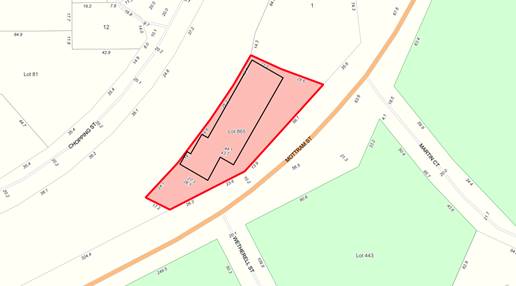
Council resolved (Resolution 28587) to approve the proposal subject to a Traffic Impact Assessment and Transport Management Plan being prepared, submitted and approved within 120 days of the approval.
An excerpt of the Council minutes relating to the matter are appended.
APPENDIX: 9.5.4(A)
The business owner has requested an extension of time beyond the 120 days outlined in Condition g) to allow for more planning work in relation to access agreements with Main Roads WA (MRWA). The time extension request is made until 30 April 2022.
A copy of the request is provided attached.
ATTACHMENT: 9.5.4(1)
On a separate but related matter, it has been observed that the washing down of vehicles on-site has continued contrary to Condition b) as also imposed by Council. Council is requested to consider what action, if any, should be taken for a breach of the conditions of approval.
PUBLIC Consultation Undertaken:
The application was referred to Main Roads WA in accordance with clause 10.1 of the Shire of Manjimup Local Planning Scheme No. 4 (the Scheme).
COMMENT (Includes Options):
The provisions of the Scheme include the subject land within the Town Centre zone. With respect to the request the following comments are offered:
Previous Communication – Traffic Management
The following is a summary of previous communications with the applicant/landowner in respect of the need for Transport Management/Traffic Management Plans associated with the operation of the transport company on-site:
· 11/9/2019 – Meeting held between CEO, Director of Development and Regulation with the landowner’s representative and others where the need for the application, supported by a transport management plan was discussed;
· 10/10/2019 – Correspondence from the landowner’s respresentative requesting 4-6 month extension to appoint Traffic Management Consultants;
· 5/2/2020 – Email from CEO to the landowner’s representative checking on the progress of the Plan;
· 5/2/2020 – Email from the landowner’s representative requesting small extension;
· 20/5/2020 – The applicant advised via email that he had on behalf of the landowner’s, engaged engineer to overlay slip lane and address access management. Advised 1 month to complete;
· 12/1/2021 – email from CEO requiring lodgement of application by February 2021;
· 11/6/2021 – Application received for Change of Use, without supporting Traffic Management/Access Management Plan;
· 30/6/2021 – Email from the applicant requesting that the matter be put to Council with submitted information.
· 14/7/2021 – Comments received from Main Roads WA;
· 12/8/2021 – Correspondence forwarded to applicant requesting payment of additional fees relating to retrospective nature of application, amended site plans including the accurate depiction of Weatherall Street and additional technical information relating to truck movements and other matters;
· 24/7/2021 – Application for Planning Approval formally received after fees paid;
· 23/8/2021 – Conditional approval granted in accordance with Council resolution, requiring submission and approval of a Traffic Impact Assessment and Transport Management Plan within 120 days; and
· 4/11/21 – Email from applicant advising that he had been in negotiation with Main Roads since the approval, that Main Roads are happy with the access management plan and waiting on Main Roads engineer. He also indicated that he had been told by Rob Barnsley (Director South West Operations) that Main Roads had been in contact with planning at the Shire.
Subsequently through emails and discussions with Main Roads, Main Roads officers have advised that:
· They require the submission of an access design based on certain criteria, based on access from SW Highway only (unless agreement reached with the Shire);
· Main Roads requires the submission of an Application to Conduct Works in the MRWA Road Reserve including contractors details etc;
· Main Roads also require the submission of the Traffic Impact Assessment and Transport Management Plan as required by the Shire.
Basis of Request
As detailed in the submitted correspondence, the applicant has outlined the impact on the timing of the condition compliance being as a result of a delay from Main Roads. The author of this report has confirmed with Main Roads WA that from the time that the applicant engages a consultant to undertake a design the negotiation with MRWA can take between 3-4 months to resolve.
Although the applicant has stated that this was due to MRWA’s construction season, this is not entirely correct. Main Roads, whilst acknowledging there has been some delays in corresponding with the applicant, has advised that in their experience, the completion of detailed designs by the applicant and subsequent negotiations will unlikely be finalised before the end the construction season. Therefore the construction of the access is unlikely to occur before the next construction season.
As reflected within the summary of previous communications section above, Shire Officers have since September 2019 been conveying the need to complete a Transport Management/Access Management Plan in support of an application for the change of use. Whilst the Shire was previously advised via email in May 2020 that an engineer had been engaged on behalf of the landowner, neither the Shire nor Main Roads has been provided with a Transport Management/Access Management Plan demonstrating how the safe ingress and egress of commercial vehicles could occur.
Should Council agree to the proposed time extension, it is recommended that the proponent be advised that no further time extensions will be granted and legal action may be undertaken for non-compliance with the conditions of approval dated 23 August 2021.
Washing Down of Vehicles
In August, Council was advised on the fact that the subject property has been identified as “possibly contaminated – investigation required” and that although the source of the contaminants was not known, Shire officers had witnessed vehicles being washed down onsite. Condition b) was imposed prohibiting the further washing down of vehicle unless otherwise approved by the Shire. Since the condition of approval was imposed several Shire officers have further witnessed the washing down of trucks at the property. Attached are screenshots taken from Shire vehicle dash cam videos.
ATTACHMENT: 9.5.4(2)
Notwithstanding the request for an extension of time, there has been a clear breach of conditions of planning approval. To ensure that this practice ceases immediately, it is recommended that a Direction to Cease be issued in accordance with Section 214 of the Planning and Development Act 2005.
Conclusion
Shire officers acknowledge that the applicant has been delayed by a third party to some extent, however as there was no previous attempts made to commence negotiations prior to November 2021, some assurances are sought for regular updates over the next four months on the progress of the consultant should the time extension be granted.
STATUTORY ENVIRONMENT:
Planning and Development Act 2005.
Policy / Strategic Implications:
Support of the applicants request for additional time would be consistent with the following Strategies identified within the Shire of Manjimup Strategic Community Plan 2021-2031:
B1. Build on the Manjimup town’s capacity as a regional service centre for the Warren Blackwood.
B10. Ensure the regulatory environment is easy to navigate and development, business friendly environment.
B12. Provide development opportunities and support local small businesses to thrive.
Organisational risk management:
There is minimal risk associated with approving the applicant’s request. Should the applicant fail to comply with the revised timeline, further action may be considered at that time
Financial Implications:
The retrospective application fees have been paid for by the landowner and applicant.
Sustainability:
Environmental: The subject property is listed as possibly contaminated – investigation required.
Economic: Nil.
Social: Nil.
VOTING REQUIREMENTS: SIMPLE MAJORITY
|
That Council: 1. Approve the applicants request for additional time to complete the Traffic Impact Assessment and Transport Management Plan required in association with Application TP121/2020, DA20/134; 2. Amend Condition No. g) of Planning Approval TP121/2020, granted by Council 21 August 2021, to read as follows: “g) Prior to 30 April 2022 the applicant is to submit, and have approved a Traffic Impact Assessment and Transport Management Plan that includes a detailed implementation schedule, ensuring completion of the require works prior to 30 April 2023 to the satisfaction of the Shire of Manjimup and Main Roads WA.” 3. Advise the applicant that with regards to Condition g) that the timeframe includes the approval by the Shire and Main Roads WA and that periodic review meetings are recommended and it is also recommended the Shire be provided with updates on a monthly basis; 4. The proponent be advised that no further extensions of the time period’s outlined in point 2 will be granted; 5. Note the Chief Executive Officer will commence legal action for a breach of the conditions of planning approval should the timelines outlined within point 2 above not be met; and 6. Request the Chief Executive Officer issue a Direction under Section 214 of the Planning and Development Act 2005, ordering that the washing down of vehicles cease immediately in accordance with conditions imposed under Planning Approval TP121/2020.
|
|
ATTACHMENTS |
||
|
1⇨ |
Attachment 1 - Request for Time Extension |
1 Page |
|
2⇨ |
Attachment 2 - Footage of Vehicle Wash Down |
3 Pages |
|
APPENDICES |
||
|
a⇨ |
Appendix A - Excerpt from Council Minutes 19 August 2021 |
25 Pages |
58
APPENDIX
9.5.5 Proposed Revision of Local Planning Policy 6.1.17 Greenlands Estate Residential Development Standards
|
PROPONENT |
Shire of Manjimup |
|
OWNER |
Greenland Pty Ltd |
|
LOCATION / ADDRESS: |
Lot 103-121, Lot 9000 and Lot 9001 Golf Links Road, Pemberton |
|
WARD: |
West |
|
ZONE: |
Special Use Zone No 7 |
|
DIRECTORATE: |
Development and Regulation |
|
FILE REFERENCE: |
F161518 |
|
LEGISLATION: |
Planning and Development Act 2005 |
|
AUTHOR: |
Jocelyn Baister |
|
DATE OF REPORT: |
25 November 2021 |
|
DECLARATION OF INTEREST: |
Nil |
Background:
At its Ordinary Meeting held 6 May 2021, Council considered the review of 15 Local Planning Polices and approved draft versions for advertising purposes. Subsequently following the close of advertising, Council at its Ordinary Meeting held on 8 July 2021 adopted all policies with the exception of Local Planning Policy 6.1.17 Greenland Residential Development Standards (LPP 6.1.17), due to two submissions received on that draft Policy.
Having regard to the two submissions on draft LPP 6.1.17, Shire Officers recommended a further review of the Policy. A copy of the current adopted version of the Policy and the version as previously advertised are appended.
APPENDIX: 9.5.5(A)
APPENDIX: 9.5.5(B)
Shire Officers have now reviewed the Policy in consultation with representatives of the developer, and now request Council approval to advertise the revised policy. A summary of the proposed changes is provided in the comment section below. A copy of the draft revised policy is attached.
ATTACHMENT: 9.5.5(1)
PUBLIC Consultation Undertaken:
As mentioned above submissions were received on behalf of the developer during the initial public comment period. Since the advertising closed a comment was received by a prospective purchaser of one of the newly created lots on Golf Links Road. Both submissions are attached.
ATTACHMENT: 9.5.5(2)
Prior to adoption by Council, advertising of the draft policies is required to be undertaken in accordance with the Planning and Development (Local Planning Schemes) Regulations 2015 (the Regulations), Schedule 2, clause 4
(1).
COMMENT (Includes Options):
Local Planning Policies are used by Local Government to assist in making decisions under the Scheme. They provide guidance to applicants and Shire Officers as to particular requirements or considerations that are applicable when determining applications for the Shire’s prior planning consent.
In accordance with Schedule 2, clause 3 of the Regulations, local planning policies may be prepared and adopted in respect of a particular use class or general planning issues and may apply to the whole Scheme area or to part or parts of the Scheme area specified in the policy.
To assist Council in understanding the proposed changes to the 6.1.17 Policy from the version previously advertised further discussion is provided below.
Format
The format of the Policy has been changed to provide performance criteria and acceptable provisions against each design element. This will ensure that an applicant can have a level of certainty around the desired intent of the design element and suggested ways that the element can be delivered.
Background
This section has been summarised without losing the intent to inform an applicant that a high design standard is required.
Site Responsive Design
Incorporating site responsive solutions from state policy, an additional design principle has been included which requires development to consider the natural topography of the site and discourages extensive excavation/fill.
Materials and colours
Additional flexibility within limits has been incorporated to allow for additional materials and colours to be included in dwelling design as highlight elements.
Privacy Screening
The deemed to comply provisions have been amended to ensure that an applicant considers the screening as visually permeable and located within the building envelope of the dwelling.
Vegetation
This section has been strengthened to reiterate to landowners that the buffer vegetation to Golf Links Road is to be maintained.
Conclusion
A comprehensive review of the Policy has been undertaken in consultation with the developer and prospective purchasers. The proposed draft policy will deliver contemporary planning guidance to Shire officers and developers.
STATUTORY ENVIRONMENT:
Local planning policies prepared in accordance with Schedule 2, clause 4 (1) of the Regulations are required to be advertised for public comment over a period of not less than 21 days.
Policy / Strategic Implications:
The draft Policy aims to deliver a number of strategies from the Shire of Manjimup’s Strategic Community Plan such as:
B10. Ensure the regulatory environment is easy to navigate and development, business and industry-friendly.
B12. Provide development opportunities and support local small businesses to thrive.
E4. Develop policy established from well-researched and evidence-based data.
Organisational risk management:
Nil.
Financial Implications:
The cost of advertising the proposed Local Planning Policies will be partially contained within the 2021/22 annual budget as adopted by Council.
Sustainability:
Environmental: Nil.
Economic: Nil.
Social: Nil.
VOTING REQUIREMENTS: SIMPLE MAJORITY
|
That Council: 1. Adopt, for the purposes of advertising draft Local Planning Policy 6.1.17 Greenlands Estate Development Standard, as shown at Attachment: 9.5.5(1); 2. Request the Chief Executive Officer to advertise the proposed draft Local Planning Policy referred to in point 1 above for a period of not less than 21 days through advertisement in all local newspapers circulating within the district and the Shires website; and 3. Await a further report on the proposed draft policies following the close of advertising.
|
|
ATTACHMENTS |
||
|
1⇨ |
Attachment 1 - Draft LPP 6.1.17 Greenlands Estate Development Standards |
9 Pages |
|
2⇨ |
Attachment 2 - Submissions Received |
14 Pages |
|
APPENDICES |
||
|
a⇨ |
Appendix A - LPP 6.1.17 Greenlands Estate residential Development Standards |
4 Pages |
|
b⇨ |
Appendix B - draft LPP 6.1.17 Greenlands Estate Residential Development Standards |
7 Pages |
64
9.5.6 Proposed Dwelling - Single at Lot 110 (fmr Lot 1) Golf Links Road, Pemberton
|
PROPONENT |
WA Country Builders Pty Ltd |
|
OWNER |
Greenland Pemberton Pty Ltd on behalf of T & P Ryslink |
|
LOCATION / ADDRESS: |
Lot 110 (fmr Lot 1) Golf Links Road, Pemberton |
|
WARD: |
West |
|
ZONE: |
Special Use Zone – Area No 7 |
|
DIRECTORATE: |
Development and Regulation |
|
FILE REFERENCE: |
DA21/115 P54487 |
|
LEGISLATION: |
Planning and Development Act 2005 |
|
AUTHOR: |
Jocelyn Baister |
|
DATE OF REPORT: |
26 November 2021 |
|
DECLARATION OF INTEREST: |
Nil |
Background:
Council is requested to consider an application for a Dwelling – Single and rainwater tank at Lot 110 (fmr Lot 1) Golf Links Road, Pemberton. The subject property is 1 hectare in area and is situated on the south side of Golf Links Road. The land is vacant except for a Western Power pole. Lot 110 has recently been created through the subdivision of Lot 1, 200, 201 and 801 Golf Links Road, Pemberton. A location plan is shown below.
LOCATION PLAN
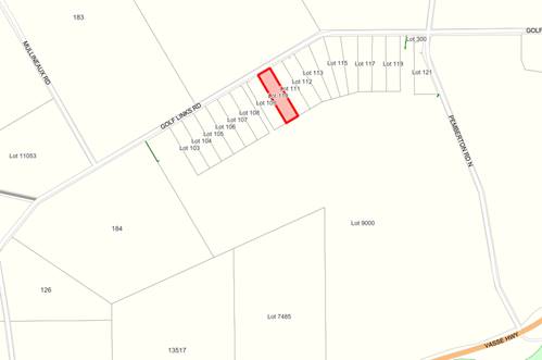
The applicant is proposing the development of a four bedroom, two bathroom dwelling with open plan living area, alfresco and outdoor living areas. Materials selected for the proposal are weatherboard, face-brick, cement render and a Colorbond roof. A rainwater tank with a capacity of 162,890 litres is also proposed. A copy of the proposal is attached.
ATTACHMENT: 9.5.6(1)
Council is requested to consider the application as variations to Local Planning Policy 6.1.17 Greenlands Estate Residential Standards (the Policy).
PUBLIC Consultation Undertaken:
The application was referred to the adjoining neighbours for comment for a period of 21 Days. Consultation closed on 22 November 2021. No comments were received during this period.
COMMENT (Includes Options):
The provisions of the Shire of Manjimup’s Local Planning Scheme No. 4 (the Scheme) include the subject land within the Special Use Zone 7. The purpose of the zone is to provide for those developments, which because of their special nature or complexity, cannot be appropriately located in other Scheme zones and which may consist of multiple uses.
Matters to be Considered
Clause 10.2 of the Scheme prescribes that in determining applications for planning approval, the local government must have regard to various matters. Relevant considerations for the subject application are as follows:
(i) the aims and provisions of the Scheme and any other relevant Local Planning Scheme operating within the Scheme area;
(vi) the local government’s adopted Local Planning Strategy and any Local Planning Policy adopted by the local government under Clause 2.4…
(x) the compatibility of a use or development with its setting including the potential impact on the use and enjoyment of adjacent and nearby land and taking into consideration any Special Control Area; and
(xvi) the relationship of the proposal to development on adjoining land or on other land in the locality including but not limited to, the likely effect of the height, bulk, scale, orientation and appearance of the proposal.
Schedule Six – Special Use Zone 7
The Schedule states that a structure plan is to be prepared and approved prior to the commencement of any subdivision and that subdivision and development shall generally reflect the Subdivision and Development Concept Plan. A structure plan for the land fronting Golf Links Road was endorsed by the Western Australian Planning Commission in 2013. The Schedule also conditions that Building Design Guidelines are to be prepared, which has occurred.
Standards Prescribed by the Policy
The proposal has been assessed against the development standards of the current Policy and complies, with the exception of portion of the proposed roof pitch. As reflected on the submitted plans, the proposed home essentially consists of two distinct wings either side of a “free form living area”. Whilst the majority of the home has been designed with a roof pitch of 25 degrees, the roof over the free form living area and associated outdoor living area have been designed with a 12 degree pitch. In addition the proposed eaves are 250mm in lieu of the 550mm specified by the policy.
Where an application requires a variation to an acceptable development provision it is required to be assessed against the performance criteria of the Policy.
The following performance criteria applies to development within the Greenlands Estate:
“Development of lots within the Policy area is to provide for low density residential development in a rural setting consistent and compatible with adjacent land use activities, landscapes and the environmental attributes of the locality”.
The proposed variations only relate to portion of the built form of the proposed dwelling and are therefore considered to be a minor variation to the acceptable development provisions. The overall development is low density and has been set back to be compatible with the adjacent land use activities. The development is considered to meet the performance criteria of the Policy.
It should be noted that Local Planning Policy 6.1.17, relating to the Greenlands Estate Residential Standards has been reviewed as is the subject of Item No 9.5.12. Whilst the draft revised Policy provides greater flexibility in assessing variations, the timing of the application resulted in the application being assessed against the requirements of the current Policy.
Water for Fire Fighting
In accordance with Part 5.24 of the Scheme, where a dwelling is proposed without connection to a reticulated water supply, a rainwater catchment tank is required to be a minimum of 135,000 litres. Whilst the proposed rainwater tank exceeds this requirement, a condition must be imposed to ensure that the tanks is installed with appropriate fittings in order to make the water available for fire fighting purposes.
Conclusion
The proposed dwelling design as submitted generally complies with requirements of the Scheme and applicable Policy, with the exception of the fact that portion of the home has been designed with a 12 degree pitch roof and 250mm eaves not a 25 degree pitch with 550mm eaves as specified by the Policy. As the proposed variations relate to only portion of the home, they are considered minor and do not detract from the overall appearance of the home, conditional approval is recommended.
STATUTORY ENVIRONMENT:
Planning and Development Act 2005 and Local Planning Scheme No.4.
Policy / Strategic Implications:
The proposed development has been assessed against the Scheme and Policy.
Organisational risk management:
Nil.
Financial Implications:
The required application fee has been paid by the applicant.
Sustainability:
Environmental: The dwelling achieves an adequate separation distance to adjacent agricultural activities.
Economic: Nil.
Social: Nil.
VOTING REQUIREMENTS: SIMPLE MAJORITY
|
That Council in accordance with Part 10 of the Shire of Manjimup Local Planning Scheme No. 4 grant planning approval to the proposed Dwelling - Single at Lot 110 Golf Links Road, Pemberton (Application TP 125/2021) in accordance with the plans and specifications shown at Attachment 9.5.6(1) and subject to the following conditions and advice: 1. The development hereby approved is to be carried out generally in accordance with the plans and specifications submitted with the application and these shall not be altered and/or modified without the prior knowledge and written consent of the Shire of Manjimup.
2. All stormwater and drainage runoff is to be retained on the subject property to the satisfaction to the Shire of Manjimup; 3. An on-site potable water supply not less than 135,000 litres storage capacity shall be provided on the site and connected to the development prior to occupation of the building and to the satisfaction of the Shire of Manjimup; 4. Access shall be permitted to domestic water supplies for emergency fire fighting purposes and to facilitate this, the proposed rainwater tank is to be fitted with standard fire fighting couplings in accordance with Department of Fire and Emergency Services requirements, to enable fire fighting appliances to draw water. The valve shall be fitted so as to leave 15,000 litres capacity of water in the tank; 5. Exterior wall materials shall be of a colour within keeping with the rural elements of the landscape such as earth/sandy and/or bush green hues or heritage/manor red; 6. All perimeter fencing shall be constructed in a manner and of materials, which contribute to the rural characteristics of the locality. The standard fencing style acceptable is post and wire no greater than 1.5 metres in height, for the purpose of preserving the amenity of the area; and 7. No native vegetation on the land shall be removed, damaged, destroyed or caused to be removed, damaged or destroyed. Advice to Applicant: i. This Development approval is NOT a building permit. A building permit must be formally applied for and obtained from Building Services BEFORE the commencement of any site and/or development works. ii. Prior to commencing development, an application to construct or install an apparatus for the treatment of sewage and the disposal of effluent and liquid wastes must be submitted for the approval of the Shire of Manjimup’s Environmental Health Team, in accordance with the Health (Treatment of Sewage and Disposal of Effluent and Liquid Waste) Regulations 1974. iii. The development the subject of this planning approval, must comply with the requirements of the Health (Miscellaneous Provisions) Act 1911 and the Shire of Manjimup’s Health Local Laws 2020.
|
|
ATTACHMENTS |
||
|
1⇨ |
Attachment 1 - Plans of Proposed Development |
3 Pages |
69
9.5.7 Proposed Overheight and Oversize Outbuilding at Lot 122 (24) Wattle Crescent, Manjimup
|
PROPONENT |
Mr B G Chadwick |
|
OWNER |
Mr B G Chadwick |
|
LOCATION / ADDRESS: |
Lot 122 (24) Wattle Crescent, Manjimup |
|
WARD: |
Central |
|
ZONE: |
Residential R12.5 |
|
DIRECTORATE: |
Development and Regulation |
|
FILE REFERENCE: |
DA21/139; P54240 |
|
LEGISLATION: |
Planning and Development Act 2005 |
|
AUTHOR: |
Kaylene Roberts |
|
DATE OF REPORT: |
29 November 2021 |
|
DECLARATION OF INTEREST: |
Nil |
Background:
Council is asked to consider a development application for the establishment of an ‘Overheight and Oversize Outbuilding’ at Lot 122 (24) Wattle Crescent, Manjimup. A location plan is shown below.
Location Plan
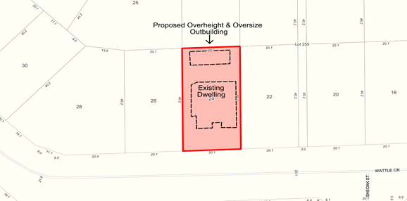
The subject property has an area of 809m² and currently contains a dwelling and two existing Outbuildings. The applicant is proposing to replace the existing outbuildings with an a single 84m² structure being 14 metres by 6 metres with a wall height of 4 metres and a ridge height of 4.8 metres. Details submitted in support of the application indicate that the Outbuilding is to be constructed of steel framing with Trimdeck® sheeting to the walls in a classic cream colour with Ironstone trims.
Copies of the submitted site and development plans are attached.
ATTACHMENT: 9.5.7(1)
Council is requested to determine the application of the proposed Outbuilding as it exceeds the maximum wall height and floor area provided for in Local Planning Policy 6.1.3 – Outbuildings (the Policy).
PUBLIC Consultation Undertaken:
The application was advertised in accordance with clause 9.6 of the Shire of Manjimup’s Local Planning Scheme No. 4 (the Scheme) for a 21 day period to the adjoining landowners. Council records indicate that the letters were sent from the Shire office on 9 November 2021 with the submission period closing on 30 November 2021. No comments or objections were received during the submission period.
COMMENT (Includes Options):
The provisions of the Scheme include the land within the Residential Zone with a density of R12.5 in accordance with the State Planning Policy 7.3 - Residential Design Codes Volume 1 (the R-Codes).
The proposed structure constitutes a domestic Outbuilding, which is defined by the Residential Design Codes as:
‘An enclosed non-habitable structure that is detached from any dwelling.’
Outbuildings within Residential zones are required to comply with the requirements prescribed by both the Scheme and Local Planning Policy.
To guide Council on the determination of this application, the following comments are offered:
Matters to be Considered
In determining an application for planning approval the local government is required to have regard to various matters as outlined within clause 10.2 of the Scheme. These matters include, but not limited to:-
(i) the aims and provisions of the Scheme and any other relevant Local Planning Scheme operating in the district;
(iii) any approved State Planning Policies of the Commission;
(iv) the local governments adopted Local Planning Strategy and a Local Policy adopted by the local government under clause 2.4, any Heritage Policy Statement for a designated Heritage Area adopted under clause 7.2.2, and any other plan or guidelines adopted by the local government under the Scheme;
(xv) the relationship of the proposal to development on adjoining land or on other land in the locality including but not limited to, the likely effect of the height, bulks, scale, orientation and appearance of the proposal; and
(xxvi) any relevant submissions received on the application.
An assessment against the above criteria is provided within the balance of this agenda item.
Policy Development Standards
Wall Height
The proposed Outbuilding complies with the development standards identified within the Policy except for the specified maximum wall height as well as the maximum floor area. Whilst the Policy provides for the wall heights of 3.0 metres, the applicant is proposing a wall height of 4 metres.
The Policy outlines that a variation of up to 10% may be permitted following referral to the neighbours for comment. In this case, the proposed wall height of 4.0 metres is 33% greater than the deemed-to-comply provisions. As a result, approval to the application can only be granted through a variation to the Policy and assessment against the design principles as prescribed by the R-Codes. Further advice on these principles is provided below.
Aggregate Floor Area
The proposed Outbuilding is to have a floor area of 84m². As outlined in the Policy, the deemed-to-comply provisions state that the Outbuildings should not collectively exceed 60m² in area or 10% of the property, whichever is the greater. In this case, 10% of the subject property is 80.9m².
In accordance with the Policy, Shire Officers may approve a variation of up to 10% (i.e 88m²), subject to neighbour consultation. As the total maximum aggregate floor area that may be approved under delegated authority is 88m², the application complies with this aspect of the Policy.
Design Principle Assessment
Applications which do not meet the deemed-to-comply provisions are assessed against the following statement as contained in the R-Codes:
Outbuildings that do not detract from the streetscape or the visual amenity of residents or neighbouring properties.
The proposed Outbuilding is shown to be located at the rear of the subject property and is in accordance with the R-Codes with regards to the setback requirements. The Outbuilding is to be setback 1.0m from the rear boundary.
With regards to the size of the Outbuilding being approximately 3.0m² over the aggregate area for Outbuildings, this variation is only likely to detract from the landowners amenity themselves, by reducing the open space available on the property. As the development will still comply with the minimum open space requirements of the R-Codes, the variation is supported.
Letter of Justification
The applicant has supplied a letter of justification for the Overheight and Oversized Outbuilding. It states that the landowner is a vehicle enthusiast and will be restoring old vehicles. A car hoist will be installed into one of the bays while the other bays will be used for parking vehicles and storage. The Outbuilding will have a mezzanine floor for the storage of parts.
Conclusion
The proposed wall height exceeds the maximum height and floor area as identified in Local Planning Policy 6.1.3 – Outbuildings. Given no objections were received to the proposal and the variations meet the design principles by not detracting from the amenity of the neighbouring properties, it is recommended the proposal be supported.
STATUTORY ENVIRONMENT:
Planning and Development Act 2005 and Shire of Manjimup Local Planning Scheme No. 4.
Policy / Strategic Implications:
Compliance with Local Planning Policy LPS4 6.1.3 Outbuildings as discussed above.
Organisational risk management:
Nil.
Financial Implications:
The required development application fee has been paid by the applicant.
Sustainability:
Environmental: Nil.
Economic: Nil.
Social: Nil.
VOTING REQUIREMENTS: SIMPLE MAJORITY
|
That Council in accordance with Part 10 of Shire of Manjimup Local Planning Scheme No.4 grants development approval for the proposed Overheight and Oversize Outbuilding on Lot 122 (24) Wattle Crescent, Manjimup (Application TP131/2021) in accordance with the plans submitted attached at 9.5.7(1) and subject to the following conditions and advice: 1. The development hereby approved must be carried out generally in accordance with the application and these shall not be altered and/or modified without the prior knowledge and written consent of the Shire of Manjimup;
2. The Outbuilding to be used for domestic purposes, storage, garaging of vehicles or other approved purposes associated with the property, excluding human habitation or commercial activity; 3. The proposed development shall be clad or coloured to complement either the surroundings in which is located or adjoining developments to the satisfaction of the Shire of Manjimup and the use of reflective materials and colours is not permitted; 4. All stormwater and drainage runoff is to be retained on the subject property and/or be provided with stormwater drainage connections to the drainage system in the area at the developers cost to the satisfaction of the Shire of Manjimup. Advice to Applicant: i) This development approval is NOT a building permit. A building permit must be formally applied for and obtained from Building Services BEFORE the commencement of any site and/or development works.
|
|
ATTACHMENTS |
||
|
1⇨ |
Attachment No. 1 - Location and Development Plans |
3 Pages |
75
9.5.8 Proposed Dam with Setback Reduction at Lot 9779 (22) Jarnadup Road, Deanmill
|
PROPONENT |
Mr T F Winfield |
|
OWNER |
Mr T F Winfield |
|
LOCATION / ADDRESS: |
Lot 9779 (22) Jarnadup Road, Deanmill |
|
WARD: |
Central |
|
ZONE: |
Priority Agriculture |
|
DIRECTORATE: |
Development and Regulation |
|
FILE REFERENCE: |
DA21/133; P51233 |
|
LEGISLATION: |
Planning and Development Act 2005 |
|
AUTHOR: |
Kaylene Roberts |
|
DATE OF REPORT: |
29 November 2021 |
|
DECLARATION OF INTEREST: |
Nil |
Background:
Council is requested to consider a development application for approval to a dam with a 5 metre setback to the northern boundary of Lot 9779 (22) Jarnadup Road, Deanmill. Plans and supporting information relating to the proposed dam are attached.
ATTACHMENT: 9.5.8(1)
ATTACHMENT: 9.5.8(2)
Location Plan
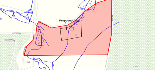
The subject property is 47 hectares in area and contains a dwelling, numerous machinery sheds, a large dam, small dam as well as avocado orchards.
Approval is being sought to construct a dam with a capacity of 27 megalitres (ML) The dam if approved will have a wall height of 5 metres with a width of 78 metres and a length of 112 metres and will have a depth of 5 metres. The applicant has supplied information regarding the bypass system as well as the spillway. There are no plans showing a pump shed for the proposed dam.
Although the applicant has applied for a catchment dam, the Shire’s mapping dataset indicates that the dam will be located on a watercourse. This data has been confirmed by the Department of Water and Environmental Regulation (DWER). DWER has also confirmed that the landowner has made application for a permit to interfere with bed and banks of the dam. Shire Officers consider this demonstrates that the applicant is aware the proposed dam is an on-stream dam and not a catchment dam as stated on the application form.
Council is requested to determine the application given that approval to the dam will require a relaxation of normal dam setback requirements relating to a property boundary.
PUBLIC Consultation Undertaken:
The application was advertised in accordance with clause 9.6 of the Local Planning Scheme No. 4 (the Scheme) and referred to the adjoining landowner for 21 days and also to DWER for a period of 42 days in accordance with the Planning and Development (Local Planning Schemes) Regulations 2015.
A submission was received from DWER, which is detailed in the comment section below and a copy of the submission is attached.
ATTACHMENT: 9.5.8(3)
COMMENT (Includes Options):
The provisions of Local Planning Scheme No 4 (the Scheme) include the subject land within the Priority Agriculture zone.
As prescribed in clause 10.2 of the Scheme, local government is required to have regard to various matters when determining an application for planning approval. These matters include but not limited to:
(i) the aims and provisions of the Scheme and any other relevant Local Planning Scheme and operating within the Scheme area;
(ii) the local government’s adopted Local Planning Strategy and any Local Planning Policy adopted by the local government under clause 2.4….;
(x) the compatibility of a use or development with its setting including the potential impact on the use and enjoyment of adjacent and nearby land and taking into consideration of a Special Control Area;
(xiv) whether the land to which the application relates is unsuitable for the proposal by reason of it being, or being like to be, subject to flooding, tidal inundation, subsidence, landslip, bushfire or any other risk.
The following comments are offered to assist Council in determining the application.
Zoning Purpose
The purpose of the Priority Agriculture zone is to provide high quality agricultural land, particularly where water resources exist, preserving existing agricultural production and allowing for new agricultural production by securing suitable land and water resources. The objectives of the Scheme relating to this zone reinforce the requirement for the protection of the rural activities.
Given the proposed dam will be used for horticultural purposes, the application is consistent with the objectives of the Priority Agriculture Zone.
Exempted Development
In accordance with clause 8.4 of the Scheme, dams located within the Priority Agriculture and General Agriculture zones are exempt from requiring planning approval where the lower edge of the dam wall, and any other part of the dam including the stored water is further than 20 metres from the boundaries of the subject land. Planning approval is required in this instance due to the application seeking a relaxation of the required setbacks to the northern boundary.
Given the proposed setbacks, approval to the proposed development may only be granted through a relaxation of the setback requirements.
Relaxation of Standards
In accordance with clause 5.5 of the Scheme, the local government may approve an application for planning approval, despite the application not complying with the standard or requirement prescribed under the Scheme. However prior to relaxing a standard, the local government must be satisfied that:
“i) approval of the proposed development would be appropriate having regard to the criteria set out in clause 10.2; and
ii) the non-compliance will not have an adverse effect upon the occupiers or users of the development, the inhabitants of the locality or the likely future development of the locality.”
In this case, a relaxation of the front boundary is consistent with the requirements of clause 10.2, and the impact of an approval on either the subject land or adjacent property has been assessed against the Policy position. The applicant has allowed for a 5 metre vehicle access road for maintenance and fire management between the toe of the dam wall and the property boundary.
Policy Assessment
The application has been assessed against the provisions of Local Planning Policy 6.1.22 – Dams (the Policy) as follows:
|
Risk Category |
Score |
|
Construction Type (On-stream – perennial stream/river) |
3 |
|
Volume (10-100ML) |
2 |
|
Wall Height (0-5m, 5-10m) |
1 - 2 |
|
Dam Wall Design (designed by others) (survey) |
3 |
|
Infrastructure Downstream (other dams) |
3 |
|
Overflow infrastructure proposed (by pass by owner (spillway needed)) |
3 |
|
TOTAL |
15-16 |
In accordance with the provision 6.3 of the Policy, dams that score above 15 when assessed against the risk matrix are considered high risk. As the dam wall has been proposed with an exact height of 5 metres it is on the cusp of the assessment criteria for wall height. Unless a height of less than 5 metres is proposed, it is recommended that the Dam be considered high risk.
As outlined in the Policy for dams that are rated as a high risk, the application shall be supported by the following information:
· a certified report on dam structure by a suitably qualified engineer;
· a dam overflow system or spillway designed by a suitable qualified engineer; and
· detailed plans including a cross-section, topographic map/site feature survey and locality plan.
Rather than defer consideration pending the submission of this detail in accordance with the adopted policy, it is recommended that the requirements be reflected through the conditions of approval.
DWER Submission
The submission received from DWER have stated that they have no objections to the proposal but have advised that if the Shire relax the setbacks they may wish to consider allowances for vehicular access or firebreaks to be constructed and/or road drainage matters.
Discussion with DWER Officers indicates that the landowner already has a valid water license, which will permit the proposed dam to be established.
Conclusion
The proposed dam has been assessed as being a high-risk dam in accordance with LPP 6.1.22 – Dams requiring additional supporting information to be provided. Given DWER has no objection to the proposal, it is recommended that conditional approval be granted.
STATUTORY ENVIRONMENT:
Planning and Development Act 2005 and Shire of Manjimup Local Planning Scheme No. 4.
Policy / Strategic Implications:
As outlined above, the application has been assessed against Local Planning Policy 6.1.22 – Dams.
Organisational risk management:
Nil.
Financial Implications:
The applicant has paid the relevant fees as per the Shire’s approved 2021-2022 fees and charges.
Sustainability:
Environmental: Nil.
Economic: Establishing a water storage area will assist towards a suitable supply of water for horticultural purposes.
Social: Nil.
VOTING REQUIREMENTS: SIMPLE MAJORITY
|
That Council in accordance with Part 10 and Clause 5.5 of the Shire of Manjimup Local Planning Scheme No. 4 grant development approval to the proposed Dam with a Reduced Setback on Lot 9779 (22) Jarnadup Road, Deanmill (TP123/2021) in accordance with the plans and specifications attached at 9.5.8(1) and 9.5.8(2) subject to the following conditions and advice: a) The development permitted shall be carried out generally in accordance with the plans and specifications submitted as listed below:
b) Prior to the commencement of the dam construction the following information is to be submitted to the Shire of Manjimup for review and approval: i. a certified report on dam structure by a suitably qualified engineer; ii. a dam overflow system or spillway designed by a suitable qualified engineer; and iii. detailed plans including a cross-section, topographic map/site feature survey and locality plan. c) The setbacks shown on the approved plans are to be measured from the toe of the dam wall; d) Water from the dam is prohibited from accumulating across property boundaries; and e) All pumps and ancillary equipment and structures being setback from property boundaries in accordance with the requirements of Shire of Manjimup Local Planning Scheme No. 4. Advice to Applicant: i) Construction of the dam is recommended to be in accordance with the Water Quality Protection Note No. 53 ‘Dam Construction and Operation in Rural Areas’. |
|
ATTACHMENTS |
||
|
1⇨ |
Attachment No. 1 - Dam Plans |
2 Pages |
|
2⇨ |
Attachment No. 2 - Additional Information |
2 Pages |
|
3⇨ |
Attachment No. 3 - DWER Submission |
2 Pages |
81
9.5.9 Proposed Dam with Setback Reduction at Lot 50 and Lot 2084 Dingup Road, Dingup
|
PROPONENT |
Mr BL Nicol |
|
OWNER |
Mr BL Nicol |
|
LOCATION / ADDRESS: |
Lot 50 and Lot 2084 Dingup Road, Dingup |
|
WARD: |
East |
|
ZONE: |
Rural Residential |
|
DIRECTORATE: |
Development and Regulation |
|
FILE REFERENCE: |
DA21/143; P55611 |
|
LEGISLATION: |
Planning and Development Act 2005 |
|
AUTHOR: |
Kaylene Roberts; Jocelyn Baister |
|
DATE OF REPORT: |
30 November 2021 |
|
DECLARATION OF INTEREST: |
Nil |
Background:
Council is requested to consider a development application for approval to a dam with a 5 metre setback to the south and eastern boundary of Lot 50 Dingup Road, Dingup. Plans and supporting information relating to the proposed dam are attached.
ATTACHMENT: 9.5.9(1)
Location Plan
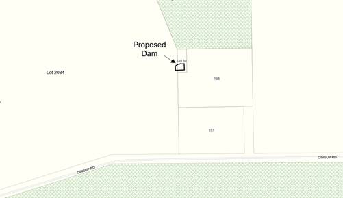
The applicant is currently in the process of amalgamating Lot 50 and Lot 2084 onto one certificate of title and has commenced investigations into a Scheme Amendment to rezone the property from Rural Residential to Priority Agriculture.
The subject properties consist of Lot 2084 which is 53.9 hectares in area and Lot 50, a smaller parcel of land being 1,011m². Lot 2084 contains a dwelling, numerous farm sheds, four water tanks as well as a new dam, that was approved in 2019.
Approval is being sought to construct a dam with a capacity of 4,000 kilolitres (KL). The dam if approved will cross the common boundary between the subject properties, will have a wall height of 3 metres with a width of 30 metres and a length of 25 metres and will have a depth of 4 metres. The applicant has stated that a spillway is to be constructed in accordance with the plans. There are no plans showing a pump shed for the proposed dam.
Council is requested to determine the application given that approval to the dam will result in development occurring across a property boundary, albeit that the landowner has made application to the Department of Planning, Lands and Heritage for approval to amalgamate the two properies.
PUBLIC Consultation Undertaken:
The application was advertised in accordance with Clause 9.6 of the Local Planning Scheme No. 4 (the Scheme). Copies of the proposal were referred to the adjoining landowners for 21 days and also to the Department of Water and Environmental Regulation (DWER) and the Department of Biodiversity Conservation and Attractions (DBCA) for a period of 42 days in accordance with the Planning and Development (Local Planning Schemes) Regulations 2015.
Submissions were received from DBCA who raised no objections and DWER who provided comments which are detailed in the comment section below and a copy of the submissions is attached.
ATTACHMENT: 9.5.9(2)
COMMENT (Includes Options):
The provisions of the Scheme include the subject land within the Rural Residential zone.
As prescribed in clause 10.2 of the Scheme, local government is required to have regard to various matters when determining an application for planning approval. These matters include but not limited to:
(i) the aims and provisions of the Scheme and any other relevant Local Planning Scheme and operating within the Scheme area;
(ii) the local government’s adopted Local Planning Strategy and any Local Planning Policy adopted by the local government under clause 2.4….;
(x) the compatibility of a use or a development with its setting including the potential impact on the use and enjoyment of adjacent and nearby land and taking into consideration of a Special Control Area;
(xiv) whether the land to which the application relates is unsuitable for the proposal by reason of it being, or being like to be, subject to flooding, tidal inundation, subsidence, landslip, bush fire or any other risk.
The following comments are offered to assist Council in determining the application.
Zoning Purpose
The purpose of the Rural Residential zone is to provide for low density residential development in a rural setting consistent and compatible with adjacent land use activity, landscape and the environmental attributes of the land.
Development Standards
The Scheme sets out minimum setbacks for buildings from a road being 20 metres and other boundaries being 10 metres. Whilst a dam is not considered a building structure, a common alternative definition of a building is “the action or trade of constructing something”.
The proposed dam if approved will be 5 metres from the eastern and southern boundaries and will cross the common boundary between Lot 50 and Lot 2084. Approval of the dam will therefore require a variation to the prescribed setback for the zone.
Relaxation of Standards
In accordance with clause 5.5 of the Scheme, the local government may approve an application for planning approval, despite the application not complying with the standard or requirement prescribed under the Scheme. However prior to relaxing a standard, the local government must be satisfied that:
“i) approval of the proposed development would be appropriate having regard to the criteria set out in clause 10.2; and
ii) the non-compliance will not have an adverse effect upon the occupiers or users of the development, the inhabitants of the locality or the likely future development of the locality.”
In this case, a relaxation of the setback to the eastern and southern boundary is consistent with the requirements of clause 10.2. That said, in terms of constructing a dam across a boundary line, this approach is generally not supported for the following reasons:
a) Ensuring ongoing and appropriate management of the dam and its associated infrastructure; and
b) The potential for the land parcel to be sold, with resultant landowners having competing interests in accessing the stored water.
Whilst the landowner has made application to amalgamate the two allotments, ensuring the dam is contained in a single land parcel, it is recommended a condition be imposed requiring that the amalgamation be finalised within 12 months of the date of approval. This approach is consistent with previous decisions on dams crossing land boundaries.
It is furthermore recommended that an appropriate condition be imposed to ensure appropriate construction of the spillway, ensuring that the required 3 metre firebreak is not impacted by waters overflowing from the dam.
Policy Assessment
The application has been assessed against the provisions of Local Planning Policy 6.1.22 – Dams (the Policy). The risk assessment indicates that the dam would be considered a high risk given the combination of the volume and the current size of the property. A second assessment is provided in the right-hand column showing the score once the properties are amalgamated.
|
Risk Category |
Score |
Score Once lots are Amalgamated |
|
Construction Type (Catchment Dam) |
2 |
0 |
|
Volume (0-10ML) |
3 |
2 |
|
Wall Height (0-5m) |
3 |
2 |
|
Dam Wall Design (designed by others) |
3 |
3 |
|
Infrastructure Downstream (Other dams) |
4 |
3 |
|
Overflow infrastructure proposed (dam bypass by others) |
2 |
1 |
|
TOTAL |
17 |
11 |
In accordance with the provision 6.3 of the Policy, dams that score above 15 when assessed against the risk matrix are considered high risk. Although a high risk score has been achieved based on the current lot size, once the amalgamation has occurred the dam will be considered a moderate risk. It is therefore recommended that should Council approve the proposed dam subject to:
a) Amalgamation of Lot 50 and 2084; and
b) Appropriate advice notes regarding construction of the dam.
DWER Submission
DWER submission states that the proposed dam has the potential to impact on water resource management. In the event there is to be any pumping or taking of surface water from watercourse or adjacent licensed dams to supplement the off-stream dam, it is advised that the applicant contact the Water Licensing branch to determine any licensing requirements.
Conclusion
Currently Lots 50 and 2084 are separate land parcels, with the subject dam proposed to cross the common boundary. The landowner has made application to the Western Australian Planning Commission to amalgamate the lots onto a single certificate of title. Provided this occurs, the resultant dam would be classified as a medium risk dam in accordance with LPP 6.1.22 – Dams.
Given the amalgamation application is in progress and DWER has no objection to the proposal, it is recommended that conditional approval be granted.
STATUTORY ENVIRONMENT:
Planning and Development Act 2005 and Shire of Manjimup Local Planning Scheme No. 4.
Policy / Strategic Implications:
As outlined above, the application has been assessed against Local Planning Policy 6.1.22 – Dams.
Organisational risk management:
Nil.
Financial Implications:
The applicant has paid the relevant fees as per the Shire’s approved 2021-2022 fees and charges.
Sustainability:
Environmental: Nil.
Economic: Establishing a water storage area will assist towards a suitable supply of water for agricultural purposes.
Social: Nil.
VOTING REQUIREMENTS: SIMPLE MAJORITY
|
That Council in accordance with Part 10 and Clause 5.5 of the Shire of Manjimup Local Planning Scheme No. 4 grant development approval to the proposed Dam with a Reduced Setback on Lot 50 and lot 2084 Dingup Road, Dingup (TP135/2021) in accordance with the plans and specifications attached at 9.5.9(1) and subject to the following conditions and advice: a) The development permitted shall be carried out generally in accordance with the plans and specifications submitted as listed below:
b) The setbacks shown on the approved plans are to be measured from the toe of the dam wall; c) Within 12 months of the date of this approval, Lots 50 and 2084 shall be amalgamated or the boundaries reconfigured to ensure that water associated with the dam does not cross property boundaries and achieves a minimum 5 metre setback; d) The proposed spillway and associated infrastructure being installed so as to ensure that any overflow waters do not detrimentally impact on required 3 metre firebreak or the adjacent land. e) Water from the dam is prohibited from accumulating across property boundaries not subject of this application and following amalgamation; and f) All pumps and ancillary equipment and structures being setback from property boundaries in accordance with the requirements of Shire of Manjimup Local Planning Scheme No. 4. Advice to Applicant: i) It is recommended that the applicant employ the services of a suitably qualified consultant in respect of the spillway/bypass details, which are to be designed, constructed and maintained to the satisfaction of the Department of Water and Environmental Regulation in accordance with the Rights in Water and Irrigation Act 1914; ii) Construction of the dam is recommended to be in accordance with the Water Quality Protection Note No. 53 ‘Dam Construction and Operation in Rural Areas’; ii) It is recommended that the applicant liaise with the Department of Water and Environmental Regulation over any licensing or other requirements in respect of the taking of surface water.
|
|
ATTACHMENTS |
||
|
1⇨ |
Attachment 1 - Plans and Information of the Proposal |
3 Pages |
|
2⇨ |
Attachment 2 - Submissions Received |
3 Pages |
84
9.5.10 Delegated Decisions for November 2021
|
PROPONENT |
Shire of Manjimup |
|
OWNER |
Various |
|
LOCATION / ADDRESS: |
Various |
|
WARD: |
Various |
|
ZONE: |
Various |
|
DIRECTORATE: |
Development and Regulation |
|
FILE REFERENCE: |
F170085 |
|
LEGISLATION: |
Planning and Development Act 2005 Local Government Act 1995 |
|
AUTHOR: |
Kaylee Blee |
|
DATE OF REPORT: |
3 December 2021 |
|
DECLARATION OF INTEREST: |
Nil |
Background:
In order to ensure the efficient and timely processing of planning related applications, Council delegates authority to the Chief Executive Officer to conditionally approve Applications for Development Approval that meet the requirements of both Local Planning Scheme No 4 (the Scheme) and adopted Planning Policy.
Delegated planning decisions are reported to Council on a monthly basis to ensure that Council has an appropriate level of oversight on the use of this delegation. A Register of Delegated Development Approvals, detailing those decisions made under delegated authority in November 2021 is attached.
ATTACHMENT: 9.5.10(1)
PUBLIC Consultation Undertaken:
Where required applications were advertised in accordance with the Scheme and Council’s adopted Local Planning Policy as detailed in the Policy/Strategic Implications section below.
COMMENT (Includes Options):
During November 2021, eleven (11) development applications were determined under delegated authority. Table 1 shows the number and value of development applications determined under both delegated authority and by Council for November 2021 compared to November 2020:
Table 1: Planning Decisions Made November 2020 and 2021
|
|
November 2020 |
November 2021 |
|
Delegated Decisions |
22 ($2,200,754) |
11 ($2,447,048) |
|
Council Decisions |
9 ($490,000) |
5 ($3,135,000) |
|
Total |
31 ($2,690,754) |
16 ($5,582,048) |
Table 2 compares the Year-To-Date statistics for delegated authority and Council decisions for 2020-21 compared to the previous Financial Year:
Table 2: Planning Decisions Made Year-To-Date 2020-21 and 2021-22
|
|
YTD 2020-21 |
YTD 2021-22 |
|
Delegated Decisions |
76 ($6,362,932) |
37 ($5,177,014) |
|
Council Decisions |
26 ($11,821,000) |
20 ($3,528,790) |
|
Total |
102 ($18,183,932) |
57 ($8,705,804) |
STATUTORY ENVIRONMENT:
The Scheme is a Local Planning Scheme, made in accordance with the Planning and Development Act 2005 and associated regulations. Part 8 of the Scheme states that prior planning approval is required for all developments (including land use), except those developments identified within Part 8.4 as being Permitted Development.
In accordance with Part 11.3 of the Scheme, Council has delegated a number of planning powers to the Chief Executive Officer. These powers have been on-delegated by the Chief Executive Officer to other staff in accordance with clause 11.3.3 of Local Planning Scheme No 4.
Clause 11.3.5 of the Scheme requires that a delegation under the Scheme is consistent with sections 5.45 and 5.46 of the Local Government Act 1995 and the regulations referred to in clause 5.46 of that Act. Regulation 19 of the Local Government (Administration) Regulations 1996 requires that a written record of each delegated decision be kept.
Policy / Strategic Implications:
Applications for Development Approval must be assessed against requirements of the Scheme and Local Planning Policies that have been adopted in accordance with Part 2 of the Scheme. These Policies include Local Planning Policy LPS4 6.1.2 Advertising of Planning Proposals, which details the level and scope of advertising required for Applications for Development Approval.
Each application processed under delegated authority has been processed and advertised, where required, and has been determined to be consistent with the requirements of all adopted Local Planning Policies.
Organisational risk management:
Nil.
Financial Implications:
The required planning fees have been paid for all applications for Development Approval processed under delegated authority.
Sustainability:
Environmental: Nil.
Economic: Nil.
Social: Nil.
VOTING REQUIREMENTS: SIMPLE MAJORITY
|
That Council receives the report on Delegated Development Approvals for November 2021 as per Attachment: 9.5.10 (1).
|
|
ATTACHMENTS |
||
|
1⇨ |
Development Approvals November 2021 |
1 Page |
86
9.5.11 Budget Amendment - Building Maintenance Vehicle
|
PROPONENT |
Shire of Manjimup |
|
OWNER |
Shire of Manjimup |
|
LOCATION / ADDRESS: |
N/A |
|
WARD: |
All |
|
ZONE: |
N/A |
|
DIRECTORATE: |
Development & Regulation |
|
FILE REFERENCE: |
F160191 |
|
LEGISLATION: |
Local Government Act 1995 |
|
AUTHOR: |
Brian Robinson |
|
DATE OF REPORT: |
6 December 2021 |
|
DECLARATION OF INTEREST: |
Nil |
Background:
The 2021/22 Annual Budget as originally adopted by Council contained an allocation to purchase a replacement vehicle for the Building Maintenance section of the Shire. The vehicle was intended to be a 4x4 Extra Cab Mitsubishi Triton.
At its Ordinary Meeting held on 21 October 2021, Council resolved to amend the adopted budget to allow the purchase of two alternative, lesser specification vehicles in order to significantly improve the efficient use of the Shire’s Building Maintenance Officers. In accordance with Council’s resolution (Resolution 28571), two Mitsubishi Triton two wheel drive vehicles were identified as the replacement vehicles.
Whilst one of these vehicles has been acquired, it has now come to light that the second vehicle will not be available for a period of some 5 months, as at the date of this agenda item. The local car dealership has identified an alternative vehicle is available for a minor additional cost.
Having regard to vehicle availability, Council is now requested to consider amendment of the current budget allocation to allow the purchase of the alternative vehicle.
PUBLIC Consultation Undertaken:
Nil.
COMMENT (Includes Options):
As outlined within the Background Section of this agenda item, whilst one of the Triton utilities has been acquired, the second vehicle will not be available for a minimum of five months.
The car dealership has now identified that a Toyota Hi-lux two wheel drive vehicle is available for an additional cost of $600. With the original vehicle shortly requiring a major service, it is recommended that the budget, as reflected within the October 2021 resolution be modified to reflect the purchase of one Mitsubishi Utility 2 wheel drive utility and one Toyota Hilux 2 wheel drive utility.
STATUTORY ENVIRONMENT:
Local Government Act 1995.
Policy / Strategic Implications:
Nil.
Organisational risk management:
Should Council not support the purchase of the proposed alternative vehicle there is a risk that replacement of the current vehicle will not occur for another 5-6 months. This could result in additional operational/running costs and a decrease in the value of the current vehicle when disposed of.
Financial Implications:
Council is advised that it is anticipated that the additional cost of $600 will be wholly contained within the approved fleet budget.
Sustainability:
Environmental: Nil.
Economic: Substitution of the specific vehicle model will allow the immediate purchase of the new vehicle and disposal of the current Mitsubishi Triton Space Cab 4wd for best value.
Social: With aging buildings, the need for suitable and proactive maintenance of Shire infrastructure is imperative to meet community expectations and the strategies and goals outlined within the 2021-2031 Strategic Community Plan.
VOTING REQUIREMENTS: ABSOLUTE MAJORITY
|
That Council: 1. Notwithstanding Resolution 28571 and having regard to the fact the identified vehicle cannot be acquired for a period of 5-6 months, amend the 2021/22 Annual Budget to allow for the substitution of one of the Mitsubishi Triton Single Cab two wheel drive Utilities with a Toyota Hilux Single Cab two wheel drive vehicle. 2. The Chief Executive Officer be requested to ensure that the additional costs associated with the purchase of the Toyota Hilux Single Cab Utility be offset by other savings within the adopted 2021/22 Annual Budget vehicle allocations.
|
9.5.12 Use of Frost Fans within the Shire of Manjimup - Potential Classification as Separate Land Use/Development
|
PROPONENT |
Shire of Manjimup |
|
OWNER |
Various |
|
LOCATION / ADDRESS: |
Whole of Shire |
|
WARD: |
All |
|
ZONE: |
Various |
|
DIRECTORATE: |
Development & Regulation |
|
FILE REFERENCE: |
F180271 |
|
LEGISLATION: |
Planning and Development Act 2005 |
|
AUTHOR: |
Brian Robinson |
|
DATE OF REPORT: |
6 December 2021 |
|
DECLARATION OF INTEREST: |
Nil |
Background:
Frost can have a significant impact on agriculture production, particularly fruit trees and vineyards, causing damage to the flowers, potentially causing the pistils of the flowers to die, preventing fruit production.
One method of mitigating the impacts of frost is the use of frost fans, whether mobile or fixed on quite large structural poles. The noise associated with frost fan use, depending on their location and the time of use has the potential to detrimentally impact on the amenity of dwellings in proximity to their location.
A landowner in Yanmah has recently installed frost fans within their orchard. As the location of the fans complied with the required setbacks for the applicable zone, it was interpreted that the fans did not require the Shire’s prior planning consent. Whilst a formal complaint has not been received, an adjacent landowner, occupying a home 1.7km away has subsequently contacted the Shire expressing concern over the timing of their use and the associated noise.
Subsequently a search of the internet has identified that the use of frost fans can be problematic in terms of the noise impact. As a result at least one other local authority in the south-west requires that planning consent is obtained prior to their installation and or use.
In order to ensure that the impacts of noise associated with frost fans, Council is requested to consider:
a) Determination of frost fans as a use requiring the separate and prior planning approval of the Shire; and
b) Preparation of a suitable Planning Policy to guide their implementation and use.
PUBLIC Consultation Undertaken:
Nil.
COMMENT (Includes Options):
The establishment of commercial orchards and vineyards within the Shire is consistent with the definition of Agriculture – Intensive as contained within Shire of Manjimup’s Local Planning Scheme No 4 and shown below:
“Agriculture – Intensive” means premises used for trade or commercial purposes, including outbuildings and earthworks, associated with the following:
(a) The Production of grapes, vegetables, flowers, exotic or native plants;
(b) The establishment and operation of plant nurseries; and
(c) The development of land for irrigate fodder production or irrigated pasture (including turf farms).
Agriculture Intensive is a use that is permissible within the Priority Agriculture, General Agriculture, Rural Small Holdings, Rural Conservation, Bushland Protection and Enterprise Zones.
Current Exemptions from Planning Approval
In accordance with clause 8.4 of the Scheme, the following land uses are identified as exempt from the need to obtain the local government’s prior planning approval:
1. In accordance with clause (iv), structures including sheds, outbuildings and carports in the Rural Residential, Rural Smallholdings, Priority Agriculture and General Agriculture Zones, which:
(a) Meet all relevant development standards, including but not limited to setbacks;
(b) Complies with any relevant Local Planning Policy applicable to these structures; and
(c) Will not be habitated overnight.
2. As outlined in clause (v) incidental structures in the Residential, Rural Rural Residential, Rural Smallholdings, Priority Agriculture and General Agriculture zones including flag poles not exceeding 6 metres and poles or towers used for lighting no more than 6 metres above natural ground level; and
3. In accordance with clause (ix) “agriculture – extensive”, agriculture – intensive, home occupation and rural pursuit in the General Agriculture zone and Priority Agriculture zone where carried out in accordance with the adopted best practice for the industry in the opinion of the local government and where it is consistent with the local government’s Local Planning Policy – Intensive Agriculture.”
Potential Impacts of Frost Fans
Frost fans by their nature are very large fans, which are either trailer mounted or placed on large pole structures. The noise associated with the fan operation is comparable with that of a wind turbine. To ensure that the use of the fans does not impact on the amenity of an area, due consideration needs to be given to their location, proximity of adjacent dwellings, time and duration of use.
Comparable Uses
Wind Farms are an “A” use within Priority Agriculture and General Agriculture Use. That is a use that is prohibited unless the approval of the local government is granted following advertising of the proposal. Wind Farms are prohibited in all other zones.
Other Local Government Approaches
It is noted that issues associated with the use of frost fans have occurred within the Shire Donnybrook-Balingup. As reflected within minutes of that Shire’s Ordinary Meeting minutes dated 24 May 2017, the issues with that situation are summarised as follows:
a) The automated fans were used over a period of 10 days over a 12 month period, with a combined running time of 38.5 hours;
b) An acoustic report demonstrated that the fans exceed the assigned (allowable) noise level at all times of the day for dwellings within a 1km radius, with four dwellings located within that radius; and
c) The operator modified operation of the fans to activate when the temperature reached zero degrees, which would reduce their operation to two days instead of 10.
In the above case, the Shire determined that planning approval was required, and granted retrospective approval to the fan operation subject to five conditions and requested the preparation of a local planning policy to provide controls and guidance on the use and location of frost fans. It is understood that this policy is yet to be finalised.
Interstate Approach
Within South Australia the installation and use of frost fans requires prior planning approval is required before the installation of a frost fans. Where on fixed poles, a building permit is also required. This is as a result of the South Australian Environment, Resources and Development Court confirming that frost fans are acceptable in-principle in Primary Production zones, subject to their impacts on amenity being deemed acceptable.
It is observed that this approach is also utilised within several other eastern state local authorities.
Conclusion
Whilst frost fans are incidental to the use of a property for orchard/fruit production and vineyards, their use has the potential to breach noise regulations and detrimentally impact on the amenity of adjacent dwellings. For this reason, it is recommended that Council:
a) Support the classification of Frost Fans as a “Use not Listed” and require the local governments prior planning approval to be obtained;
b) Determine that Frost Fans are acceptable in-principle where agriculture-intensive land uses are permitted within the Scheme and advertise any such proposals in accordance with clause 9.6 of the Scheme; and
c) Request the Chief Executive Officer prepare a draft Local Planning Policy on Frost Fans for the consideration of Council.
STATUTORY ENVIRONMENT:
In accordance with clause 4.20.2 of the Scheme, where a use is not listed within the Zoning and Development Table and cannot reasonably be determined as falling within the type, class or genus of activity of any other use category, the local government may:
a) Determine that the use is consistent with the objectives of the particular zone;
b) Determine that the use may be consistent with the objectives of the particular zone and thereafter follow the advertising procedures of Clause 9.6 in considering an application for planning approval; or
c) Determine that the use is not consistent with the objectives of the particular zone and is therefore not permitted.
In this case, it is recommended that Council determine that in accordance with clause 4.20.2 that “Frost Fans” may be consistent with the objectives of the Priority Agriculture and General Agriculture Zone, but would not be consistent with the objectives of all other zones.
Policy / Strategic Implications:
It is recommended that a draft policy be prepared for Council consideration with the view to outlining the relevant requirements and considerations for determining applications for the location of Frost Fans within the Shire.
Organisational risk management:
Should Council not determine that Frost Fans should be identified as an independent use requiring the local government’s prior planning approval, there is a risk that they may be located in a position that will detrimentally impact on the amenity of adjacent dwellings.
Financial Implications:
Nil.
Sustainability:
Environmental: Nil.
Economic: Frost fans are an effective tool for farming properties in preventing frosts from detrimentally impacting on crop yields.
Social: The operation of Frost Fans can be incompatible with the amenity of adjacent dwellings due to the associated noise.
VOTING REQUIREMENTS: SIMPLE MAJORITY
|
That Council: 1. Determine that Frost Fans are a use not listed within Local Planning Scheme No 4; 2. In accordance with clause 4.20.2 determine that Frost Fans may be compatible with the objectives of the “Priority Agriculture” and “General Agriculture” Zones and that all applications be advertised for public comment in accordance with clause 9.6 of Local Planning Scheme No 4; 3. Determine in accordance with clause 4.20.2 that Frost Fans are not compatible with the objectives of all other zones other than the Priority Agriculture and General Agriculture Zones; and 4. Request the Chief Executive Officer arrange for the preparation of a draft Local Planning Policy for Council consideration.
|
96
9.5.13 Proposed Budget Amendment - Allocation of 2021/22 Mainstreet Upgrade Budget
|
PROPONENT |
Shire of Manjimup |
|
OWNER |
Shire of Manjimup/Crown |
|
LOCATION / ADDRESS: |
Various |
|
WARD: |
All |
|
ZONE: |
N/A |
|
DIRECTORATE: |
Development & Regulation |
|
FILE REFERENCE: |
F210271 |
|
LEGISLATION: |
Local Government Act 1995 |
|
AUTHOR: |
Brian Robinson |
|
DATE OF REPORT: |
8 December 2021 |
|
DECLARATION OF INTEREST: |
Nil |
Background:
As part the 2021/22 adopted budget, consistent with previous years, Council resolved to allocate a budget of $150,000 towards Mainstreet Upgrade Projects for Townsites within the Shire. To date, this budget has not been allocated to a specific project or projects.
With effectively six months of the year remaining in the current financial year, Council is requested to considering the allocation of priority projects, allowing the works to be completed in a timely manner and the budget expended within the financial year.
PUBLIC Consultation Undertaken:
Nil.
COMMENT (Includes Options):
As detailed in the background section, the $150,000 allocation for Mainstreet Upgrade works is yet to be allocated. That said, several discussions have been held with the Shire’s Town Activation Advisory Committee’s.
Through liaison with those Committee’s, it is recommended that the budget be allocated to the following projects:
Northcliffe Pioneer Park – Carpark Drainage $26,000
At it’s Ordinary Meeting held on 21 October 2021, Council was requested to reconsider the conditions of planning approval relating to the proposed Exhibition Centre (Museum) building otherwise known as the Northcliffe Pioneer Museum’s ‘Munro House Project’. As outlined within the agenda item, the Museum was seeking Council’s review of a condition requiring the relocation of an existing stormwater pit that was in conflict with the proposed location of Munro House.
In their submission to Council, the Museum Committee suggested that the drainage works should occur in association with the overall upgrade of the public carpark. The upgrading of the carpark, including drainage, sealing and linemarking was previously presented to the then Northcliffe Town Centre Revitalisation Committee on 20 August 2019 and identified as Stage 3 of upgrade works within the Northcliffe Townsite.
As detailed in the 21 October 2021 agenda item, Shire Officers were in support of the Pioneer Museum’s suggestion that the drainage form part of the upgrade works. Consistent with the officers recommendation, Council resolved (Resolution No 28554), to “Request the Chief Executive Officer to present the proposal for the drainage upgrade works within the Pioneer Museum Carpark to the Northcliffe Town Activation Advisory Committee”.
The issue was discussed with the Northcliffe Town Activation Advisory Committee at its meeting held on 7 December 2021, where the concept of utilising funds from the 2021/22 Mainstreet Upgrade budget was supported.
Pioneer Park Carpark Upgrade, Walpole - $60,000
Utilising grant funding from the South West Development Commission, the gravel section of the Pioneer Park carpark was reconstructed and a bitumen seal was applied. As reflected within the minutes of the Walpole Town Activation Advisory Committee meeting held on 25 November 2021 (refer to Item No 9.16.6), the Committee has resolved to request that Council allocate an amount of $60,000 from the Mainstreet Upgrade Budget to complete:
a) kerbing and associated accessible compliant paths,
b) application of a red oxide asphalt seal (to match the town centre parking); and
c) linemarking.
The subject carpark services the Walpole-Nornalup Visitors Centre, Public Ablutions, Pioneer Park (including the markets) and more generally the Walpole Townsite. In its current form it does not provide disability compliant access. Given the purpose of the carpark and its use, this request is supported as identified in Item 9.16.6 of this agenda.
Parking Area at Rear of No 5 (Lot 45) Brockman Street, Manjimup - $50,000
As elected members may be aware, following the purchase of No 5 (Lot 45) Brockman Street, Manjimup, the Shire acquired additional land to the rear of No 7A and 7 Brockman Street to create a co-ordinated carpark. The purpose of the parking area was to support the development of 5-7 Brockman Street as well as events held in Brockman Street and the area generally.
The car parking area is that area shown as 38 Rose Street on the Location plan overleaf.
Whilst drainage and the primary construction of the parking area has been completed with a sacrificial bitumen surface, kerbing, an asphalt surface, line marking and associated footpaths are yet to be completed. With no specific budget allocation for completion of the capital works, it is recommended that the associated costs be met through the Mainstreet Upgrade Budget.
Location Plan
Pemberton Playground Upgrade
As part of the 2021/22 annual budget, Council allocated an amount of $35,000 towards a $70,000 the upgrade of the Playground located at Reserve 19566 Brockman Street, Pemberton. Subsequently at its Ordinary Meeting held on 9 September 2021, Council resolved to support a recommendation of the Pemberton Town Activation Advisory Committee for an amount of $15,000 of the budget to be allocated to the preparation of a masterplan for that portion of Reserve 19566 developed as Public Open Space. This reduced the amount of available Shire funding for the actual upgrade works to $20,000.
As reflected above, Shire Officers have identified a total of $136,000 of projects for Northcliffe, Walpole and Manjimup. It is recommended that the $14,000 remaining within the Mainstreet Upgrade budget be reallocated to the Budget allocation for the Pemberton Playground Upgrade.
The recommended reallocation will bring the Shire’s total contribution to $49,000, including the $15,000 design exercise. The allocation as proposed may also allow additional matching funding to be sought for the physical upgrade works. Should an increase in grant funding be achieved, a further agenda item outlining an additional budget amendment will be prepared for Council consideration.
STATUTORY ENVIRONMENT:
Local Government Act 1995.
Policy / Strategic Implications:
The proposed budget allocations are consistent with the following Community Goals and Strategies as outlined within the Shire of Manjimup Strategic Community Plan 2021-2031:
Community Goals:
3.3 We respond to an ageing demographic by cultivating age-friendly communities that are also inherently dementia and disability friendly.
3.7 Our community is vibrant, dynamic and fun because we have access to a broad range of art, cultural, social and recreational opportunities.
4.4 Town centres are accessible, attractive and inviting whilst maintaining their unique characters.
4.5 Parks and open spaces are attractive and create opportunities for people to come together, socialise and enjoy a range of activity.
Strategies:
C18. Create, support and promote a broad range sporting, recreational and social opportunities that are accessible and inclusive for all ages and abilities.
D5. Develop and maintain community infrastructure to a service-level that meets the community’s needs.
D10. Provide for public parks and playgrounds that are accessible and attractive with well-maintained amenities and equipment.
Organisational risk management:
The Pioneer Park carpark is the primary parking area for passenger vehicles associated with members of the public visiting Pioneer Park, the Walpole-Nornalup Visitors Centre and the Pioneer Park Toilets and is currently non-compliant with accessibility access standards. Upgrading of the Pioneer Park carpark will ensure an appropriately constructed carpark is available to support the existing and ongoing use of the park.
Financial Implications:
As outlined within the Comment Section above.
Sustainability:
Environmental: Nil.
Economic: Nil.
Social: Allocation of the Mainstreet Upgrade budget to the identified projects will assist the Shire in ensuring an appropriate standard of facilities within the four primary townsites.
VOTING REQUIREMENTS: ABSOLUTE MAJORITY
|
That Council approve the following amendments to the 2021/22 Annual budget:
|
97
9.5.14 Retrospective Application for a Dam with Reduced Setback at Lot 101 (17) Decampo Road, Eastbrook
|
PROPONENT |
Mr D DeCampo |
|
OWNER |
Mr B D DeCampo |
|
LOCATION / ADDRESS: |
Lot 101 (17) Decamp Road, Eastbrook |
|
WARD: |
West Ward |
|
ZONE: |
Priority Agriculture |
|
DIRECTORATE: |
Development and Regulation |
|
FILE REFERENCE: |
DA21/101 |
|
LEGISLATION: |
Planning and Development Act 2005 |
|
AUTHOR: |
Brian Robinson |
|
DATE OF REPORT: |
8 December 2021 |
|
DECLARATION OF INTEREST: |
Nil |
The following agenda item was presented to Council for consideration at its Ordinary Meeting held on 18 November 2021 whereby a motion to support the officers recommendation failed. With no alternative motion put, the matter was left to ‘lay on the table’.
On the following day, prior to 12pm, four Councillors requested that the matter be reconsidered, being Councillors Taylor, Wilcox, Ventris and Lawrence. As a result the agenda item as presented to Council in November is now represented, albeit that the officer recommendation has been modified to reflect the required administrative process.
Background:
Council is requested to consider an application for retrospective approval for an expansion to an agricultural Dam at Lot 101 (17) Decampo Road, Eastbrook. A copy of the development plans are attached, whilst an outline of the Dam is shown on the location plan below.
ATTACHMENT: 9.5.14(1)
Location Plan
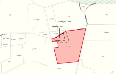
The subject property is 52.1 hectares in area and was recently involved in a subdivision/amalgamation with the surrounding land to realign boundaries. The property contains two dams and is being used predominantly for agriculture. Portion of the land abutting the Pemberton North Road and Decampo Road is developed with a transport depot. Some servicing of vehicles is undertaken within the workshop and an office building is also on the property.
It was brought to the attention of the Shire that the existing Dam had been expanded without prior planning approval. Shire Officers subsequently attended the site and inspected the Dam from the road and met the applicant on site.
As detailed in the application, the Dam has been expanded to have a capacity 230 Megalitres. The Dam has an outer wall of 4 metres and an internal wall of 7 metres in height. The dam wall has expanded in length to be a total of 280 metres. The toe of the dam wall is located on the boundary of Decampo Road.
The application is referred to Council for determination, as Shire Officers do not have delegated authority to process the application due to the retrospective nature of the proposal and any approval requiring a boundary setback variation.
PUBLIC Consultation Undertaken:
The retrospective application was advertised in accordance with Clause 9.6 of Local Planning Scheme No. 4 (the Scheme) for a period of 42 days to the Department of Water and Environmental Regulation (DWER) and for 21 days to adjoining affected landowners.
Comments were received from DWER advising that the Dam is considered exempt under the Rights in Water and Irrigation Act 1914 and there are negligible environmental impacts. A copy of the submission is attached.
ATTACHMENT: 9.5.14(2)
Correspondence was also received from the landowner seeking compassion in dealing with the matter. As outlined in that correspondence the works had been arranged by the owner’s son, who up until his passing in February this year was the farm manager. A copy of that correspondence is shown attached.
ATTACHMENT: 9.5.14(3)
COMMENT (Includes Options):
The Scheme includes the subject land within the Priority Agriculture Zone. The purpose of this zone is to provide for the sustainable use of rural land, which primarily accommodates a range of rural pursuits compatible with the land compatibility and retains the character and amenity of the locality.
In accordance with Clause 8.4 (xxiv) of the Scheme, prior planning approval is not required for Dams within the Priority Agriculture or General Agriculture zones where the lower edge of the Dam wall and any other part of the Dam including the Dam water is further than 20 metres from the property boundaries. Proposals for Dams which are setback less than the 20 metres from property boundaries require prior planning approval.
In this case the applicant has increased the historical non-compliance of an existing Dam by increasing the height and length of the wall. Additionally with the realigned property boundaries the tail water will now be less than 20 metres from an adjoining property.
As outlined within Clause 5.34.2.4 of the Scheme, development within the Priority Agriculture Zone is normally required to be setback 30 metres from the front and rear, 10 metres from the sides and if adjoining State Forest a 100 metre setback is required.
To guide Council in the determination of the application the following comments are offered:
Retrospective Approval
In accordance with Clause 8.6, planning approval may be granted to a development already commenced or completed, regardless of the date, if the development conforms to the provisions of the Scheme.
A decision to grant retrospective approval does not prevent the local government from taking action for breach of the Scheme requirements for prior approval to be obtained. In this case, the applicant was not aware of the requirement for prior approval to increase the size of the existing Dam, given no approval was required for the water license. Additionally, as the works were being undertaken under the direction of the landowner, who is now deceased, the applicant was under the assumption that all approvals had been obtained. It is understood that correspondence has been sent to Councillors explaining this circumstance.
The existing Dam was already non-complaint with the setback requirements, with the toe of the Dam wall aligned with the boundary of the road. Generally speaking, historical works that are non-complaint are not retrospectively required to seek approval, however alterations to the works that are non-compliant will always need prior approval.
Matters to be Considered
Clause 10.2 of the Scheme requires that in determining applications for development approval, the local government is required to have regard to various matters, including but not limited to:
(i) the aims and provisions of the Scheme and any other relevant Local Planning Scheme operating within the Scheme area;
(vi) the local government’s adopted Local Planning Strategy and any Local Planning Policy adopted by the local government under Clause 2.4;
(x) the compatibility of a use or development with its setting, including the potential impact on the use and enjoyment of adjacent and nearby land and taking into consideration any Special Control Area;
(xxvi) the comments and submissions received from any authority that has been consulted;
(xiv) whether the land to which the application relates is unsuitable for the proposal by reason of it being, or being likely to be, subject to flooding, tidal inundation, subsidence, landslip, bush fire or any other risk; and
(xvi) the relationship of the proposal to development on adjoining land or on other land within the locality, including but not limited to. The likely effect of the height, bulk, scale, orientation and appearance of the proposal.
These considerations are addressed within the sections below.
The Scheme
The application as submitted is consistent with the aims of the Scheme in that the land is identified as Priority Agriculture land and the resultant development will be used to support future horticultural activities. The Dam, as constructed does not however meet the setback requirements for the zone and therefore requires planning approval for the variation.
In determining an application for a reduction in setbacks, in accordance with Clause 5.34.2.4(3) the local government is required to consider a range of matters including the impact on the rural landscape and possible bush fire hazards. With a zero setback to the road historically been provided, a firebreak is unable to be achieved, however fire management could occur from the road pavement.
Special Control Area
In addition to zoning the land, the provisions of the Scheme include the subject land within Special Control Area No 1. The purpose and intent of this Special Control Area, as outlined in the Scheme is to:
a) To identify the proclaimed Public Drinking Water Source Protection Areas (PDWSA); and
b) To ensure that land use and development within PDWSA is compatible with the provisions and long-term management of water resources for public supply.
In determining any development within a PDWSA clause 5.10.1 of the Scheme requires that the local government will have due regard to the potential impact on water supplies and the compatibility of the proposed use. In addition, the Scheme states that:
“There will be a general presumption against development or use which involves significant risk to the resource. The onus is on the applicant to demonstrate that proposal will not prejudice the protection of water quality and supply.”
DWER has stated that the proposal will have negligible impacts on the environment.
Relaxation of Standards
In accordance with Clause 5.5 of the Scheme, the local government may approve an application for planning approval, despite the application not complying with the standard or requirement prescribed under the Scheme However prior to relaxing a standard, the local government must be satisfied that:
“i) approval of the proposed development would be appropriate having regard to the criteria set out in clause 10.2; and
ii) the non-compliance will not have an adverse effect upon the occupiers or users of the development, the inhabitants of the locality or the likely future development of the locality.”
In this case, given that the works were undertaken to extend a dam already established with a nil setback, a relaxation of the front boundary setback from 30 metres is supported. It is also noted that the visual impact associated with the increased length and wall height can be mitigated through bank stabilisation and plantings as proposed.
Policy Assessment
Local Planning Policy 6.1.22 – Dams (Policy) provides guidance and ensures a consistent approach when considering application for Dams. In accordance with the Policy, the level of risk is assessed having regard to factors such as the location, type of Dam the location of other Dams downstream and the Dam size and wall height.
As a result the risk assessment is as follows:
|
Risk Category |
Score |
|
Construction Type (Catchment) |
0 |
|
Volume (100ML+) |
3 |
|
Wall Height (5-10m) |
2 |
|
Dam Wall Design (Others Surveyor) |
3 |
|
Infrastructure Downstream (Roads) |
2 |
|
Overflow infrastructure proposed (none) |
4 |
|
TOTAL |
14 |
In accordance with provision 6.2 of the Policy, Dams that score between 10 and 15 are considered moderate risk. Should Council seek to approve the application, it is recommended that an advice note be included on any approval advising the landowners that they are responsible for the structural integrity of the Dam construction and also recommending that the proposed structure be certified by an appropriately experienced contractor or qualified engineer, in accordance with the Policy provisions.
Potential for Legal Action
As the Dam was constructed without the required prior planning consent, there is potential for Council to:
a) Resolve to take legal action for a breach of the Scheme; or
b) Issue a modified penalty of $500 in accordance with the provisions of the Planning and Development Act 2005 and associated regulations.
Elected members are advised that the ability for a penalty to be issued, or legal action to be taken is clearly reflected within the Planning and Development Act 2005.
Given the original dam was established with a nil setback to the road reserve, and having regard to the landowners correspondence shown at Attachment: 9.5.14(3), it is recommended that no further action be taken for the unauthorised works.
Conclusion
The expansion to the Dam has been assessed as a moderate risk. Conditional approval of the Dam is recommended.
STATUTORY ENVIRONMENT:
Planning and Development Act 2005 and Shire of Manjimup Local Planning Scheme No. 4.
Policy / Strategic Implications:
As outlined above, the application has been assessed against Local Planning Policy 6.1.22 – Dams.
Organisational risk management:
By not imposing consistent recommendations to take legal action there is a risk that compliance matters will increase within the community.
Financial Implications:
The required development fee for retrospective approval has been paid by the applicant.
Sustainability:
Environmental: Nil.
Economic: Establishing a water storage area will assist towards a suitable supply of water for horticultural purposes.
Social: Nil.
VOTING REQUIREMENTS: SIMPLE MAJORITY
|
Step 1 consent in accordance with the local government (administration) regulations 1996
The following four Councillors consent to the consideration of a Motion to rescind Council’s decision of 18 November 2021 not to support the officer recommendation relating to the proposed retrospective application for planning approval to a Dam on Lot 101 (17) Decampo Road, Eastbrook:
Cr Taylor Cr Wilcox Cr Ventris Cr Lawrence
STEP 2 (If Consent is granted from Step 1 – Absolute Majority required) Motion:
That Council revoke its decision not to support the officer recommendation in relation to Agenda Item 9.5.1 on 18 November 2021.
STEP 3 (Only if Step 2 is carried by Absolute Majority) MOTION:
That Council grant retrospective development approval in accordance with clause 8.6, Part 10 and Clause 5.5 of the Shire of Manjimup Local Planning Scheme No. 4 to the Dam with a Reduced Setback on Lot 101 (17) Decampo Road, Eastbrook in accordance with the plans and specifications attached at Attachment: 9.5.14 (1) subject to the following conditions and advice: a) The development permitted shall be carried out generally in accordance with the plans and specifications submitted as listed below:
b) Water from the Dam is prohibited to accumulate across property boundaries; c) Overflow waters associated with the Dam hereby approved shall not result in the accumulation of water or erosion on the adjacent property or road reserve to the satisfaction of the Shire of Manjimup. d) All pumps and ancillary equipment and structures being setback from property boundaries in accordance with the requirements of Shire of Manjimup Local Planning Scheme No. 4. Advice to Applicant: i) The proponent is advised that it is the responsibility of the landowner to ensure that the Dam is safely constructed and maintained and that it is recommended that the proposed structure be certified by a suitably qualified contractor or engineer. ii) Construction of the Dam is recommended to be in accordance with the Water Quality Protection Note No. 53 ‘Dam Construction and Operation in Rural Areas’.
|
|
ATTACHMENTS |
||
|
1⇨ |
Attachment 1 - Development Plans and Information |
4 Pages |
|
2⇨ |
Attachment 2 - DWER Comments |
1 Page |
|
3⇨ |
Attachment 3 - Correspondence from landowner |
1 Page |
108
APPENDIX
9.12.1 Consideration for Proposed Closure and Amalgamation of a Portion of Unnamed Road Reserve in the Vicinity of Fox Road, Eastbrook after Further Consultation with Adjoining Owners
|
PROPONENTS |
G Pilat M & K Fox P Barnsby |
|
OWNER |
Shire of Manjimup |
|
LOCATION / ADDRESS: |
Unnamed Road Reserve |
|
WARD: |
West Ward |
|
ZONE: |
Road Reserve |
|
DIRECTORATE: |
Works & Services |
|
FILE REFERENCE: |
F200115 |
|
LEGISLATION: |
Local Government Act 1995 Land Administration Act 1997 |
|
AUTHOR: |
Yvonne Ganfield |
|
DATE OF REPORT: |
1 November 2021 |
|
DECLARATION OF INTEREST: |
Nil |
Background:
At the Ordinary Council Meeting of 15 April 2021, Council resolved to support the revised closure of portions of unnamed and unconstructed road reserve in the vicinity of Fox Road, Eastbrook with subsequent amalgamation into the adjacent Lot 9421 and Lot 1 as shown in the location plan below. A copy of the report is appended.
APPENDIX: 9.12.1(A)
Location Plan
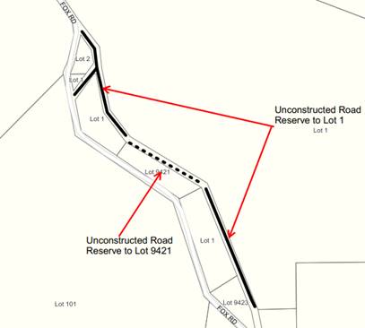
In accordance with Council’s resolution, the proposal was forwarded to the Minister of Lands for approval as required in Section 58 by the Land Administration Act 1997 and associated Regulations. On 8 September 2021 the Shire received notice from the Department of Planning, Lands & Heritage (DPLH) requesting further details from the Shire regarding its consultation with two of the adjoining landowners in relation to their absence of any comment. As such, the Shire then requested written confirmation from the two landowners confirming their position regarding the adjoining portion of unconstructed road reserve. As a result, Mr Barnsby then requested to purchase portion of the road reserve. Council is now requested to again consider the road closure and provide an updated resolution.
PUBLIC Consultation Undertaken:
Nil.
COMMENT (Includes Options):
Following on from its resolution from the Ordinary Council Meeting of 15 April 2021, the Shire has received a request from Mr Barnsby to purchase a portion of the unnamed road adjacent to his property. As there are now three proponents wishing to purchase portions of the road closure, Council approval is required to accommodate Mr Barnsby’s request.
It is therefore recommended that Council resolve to approve closure of portions of unconstructed road reserve and subsequent amalgamation into:
· Lot 1 Fox Road, Eastbrook (G Pilat) as shown in the attached map;
ATTACHMENT: 9.12.1(1)
· Lot 9421, Fox Road, Eastbrook (M & K Fox) as per the attached map; and
ATTACHMENT: 9.12.1(2)
· Lot 9423 Fox Road, Eastbrook (P Barnsby) as per the attached map.
ATTACHMENT: 9.12.1(3)
STATUTORY ENVIRONMENT:
To enable the closure of a public road, the Land Administration Act 1997 prescribes a public consultation period followed by a resolution of Council after which the proposal is submitted to DPLH.
The Local Government Act 1995 requires public notice for partial or whole road closure.
Policy / Strategic Implications:
Closing unrequired road reserves serves to reduce the overall land management potential burden on Council. The approximate area to be closed through this proposal is 23,350m2.
Organisational risk management:
Nil. Prior to Council initiating a road closure process, there is an obligation to ensure that the proposal will not result in land locked issues (i.e. lots with no road access) nor additional costs being imposed on the Shire. Both issues have been negated.
Financial Implications:
There are no financial implications for Council. The progression of the road closure is on the basis that the proponents pays all fees and assumes all the associated costs including survey fees. The Shire fee for this process is $990 and an invoice has been paid by the proponent. Future sale of the closed portion of the unconstructed road reserve will be entirely negotiated by the Department of Planning, Lands and Heritage.
Sustainability:
Environmental: Nil.
Economic: Reducing the number of unconstructed road reserves within the Shire that provide no strategic importance reduces unnecessary land administration activities by the Shire.
Social: Open and transparent communication ensures the Shire is acting with fairness and equity to all parties.
VOTING REQUIREMENTS: SIMPLE MAJORITY
|
That Council; 1. Advise the applicants that Council supports the revised closure of the portions of Unnamed Road Reserve in the vicinity of Fox Road, Eastbrook with subsequent amalgamation into the adjacent Lot 1 as per attachment: 9.12.1 (1), Lot 9421 as per attachment: 9.12.1(2) and Lot 9423, as per attachment: 9.12.1(3);
2. Grant delegated authority to the Chief Executive Officer to forward a request to the Minister for Lands for approval to close that portion of road reserve in accordance with Section 58 of the Land Administration Act 1997; and
3. Indemnify the Minister for Lands against any claim for compensation resulting from the proposed road closure.
|
|
ATTACHMENTS |
||
|
1⇨ |
Lot 1 G Pilat |
1 Page |
|
2⇨ |
Lot 9421 M & K Fox |
1 Page |
|
3⇨ |
Lot 9423 P Barnsby |
1 Page |
|
APPENDICES |
||
|
a⇨ |
Proposed Closure and Amalgamation of a Portion of Unnamed Road Reserve in the Vicinity of Fox Road, Eastbrook - Ordinary Meeting - 15 April 2021 |
12 Pages |
111
APPENDIX
9.15.1 Unconfirmed Minutes of the Airfield Management Committee Meeting held on 24 November 2021
|
PROPONENT |
Shire of Manjimup |
|
OWNER |
Shire of Manjimup |
|
LOCATION / ADDRESS: |
Dawn Road, Manjimup |
|
WARD: |
Central |
|
ZONE: |
Public Purposes |
|
DIRECTORATE: |
Works & Services |
|
FILE REFERENCE: |
F170380 |
|
LEGISLATION: |
Local Government Act 1995 |
|
AUTHOR: |
Yvonne Ganfield |
|
DATE OF REPORT: |
25 November 2021 |
|
DECLARATION OF INTEREST: |
Nil |
Background:
The purpose of this report is to accept the unconfirmed minutes of the Airfield Management Committee meeting held 24 November 2021. A copy of the unconfirmed minutes are attached.
ATTACHMENT: 9.15.1(1)
PUBLIC Consultation Undertaken:
Nil.
COMMENT (Includes Options):
The committee made the following recommendations due to the election of the new Chairperson and changes made in member representation for Department of Biodiversity, Conservation and Attractions (DBCA) and the Manjimup Aero Club. These changes will require update of the current Terms of reference, which are appended.
APPENDIX: 9.15.1(A)
|
Committee Recommendation |
Officer’s Comment |
|
That Cliff Winfield be elected as Chairperson of the Shire of Manjimup Airfield Management Committee. |
Supported and noted in the amended Terms of Reference. |
|
The Committee accepted Simon Hunter as the new appointed representative for the Manjimup Aero Club. |
Supported and dealt with as part of the recommendations to Council in this report. |
|
The Committee accepted to change the Terms of Reference for two (2) Deputy Airport Reporting Officers, and accepted the nomination of Bruce Ward. |
Supported and dealt with as part of the recommendations to Council in this report. |
|
The Committee accept Nathan Ramage as the new appointed member as the DBCA representative and Jeff Bennett to be proxy. |
Supported and dealt with as part of the recommendations to Council in this report. |
|
That the Airfield Management Committee request a meeting as soon as practical with the Shire President, Chief Executive Officer and Senior Executive Officers to discuss the upgrading of Airport facilities with the intention to submit an application for funding to the ‘Timber Transition Group’. |
Not supported. Given there has been no announcement of any available funding for these type of works, the committee should instead strategically workshop priorities of works with a detailed costing to be presented to Council at one of Council’s Information Briefing sessions. |
There was discussion around the impact that the impending closing of native forest logging will have on the Airport and facilities, which raised genuine concerns for the Committee, and a recommendation to meet with the President, Chief Executive Officer and other Senior Management was tabled. The Committee’s representative of the Manjimup Aero Club provided the Committee a list of suggested works that he believes are required. The list is attached for Council’s information.
ATTACHMENT: 9.15.1(2)
As a result of these recommendations, the current Terms of Reference has been updated and is attached for Council’s consideration
ATTACHMENT: 9.15.1(3)
STATUTORY ENVIRONMENT:
Local Government Act 1995.
Policy / Strategic Implications:
The airport services a large geographical area providing emergency access to firefighting and hospitals.
Organisational risk management:
There is no risk to the organisation with Council accepting the minutes and recommendations contained in this report.
Financial Implications:
In accordance with Council’s adopted budget.
Sustainability:
Environmental: Nil.
Economic: Nil.
Social: The Airport is critical infrastructure to the community.
VOTING REQUIREMENTS: ABSOLUTE MAJORITY
|
That Council: 1. Receive the unconfirmed Minutes of the Airfield Management Committee Meeting, held 24 November, 2021, as shown in Attachment: 9.15.1(1); 2. Note the election of Councillor Cliff Winfield as Chairperson; 3. Endorse the following changes of membership to the Manjimup Airfield Management Committee; a. Accept the resignation of Bruce Ward as the Manjimup Aero Club Representative; b. Appoint Simon Hunter as the Manjimup Aero Club Representative; c. Appoint Bruce Ward as a Deputy Airport Reporting Officer; d. Accept the resignation of Alison Raper as the Department of Biodiversity, Conservation and Attractions representative; e. Appoint Nathan Ramage as the Department of Biodiversity, Conservation and Attractions representative and Jeffrey Bennett as the Department of Biodiversity, Conservation and Attractions representative proxy; and 4. Amend the Terms of Reference for the Airfield Management Committee as per Attachment: 9.15.1(3). |
|
ATTACHMENTS |
||
|
1⇨ |
Airfield Minutes 24 November 2021 |
3 Pages |
|
2⇨ |
Manjimup Airport Upgrading Funding Proposal |
2 Pages |
|
3⇨ |
Airfield Management Committee Terms of Reference 2021 - 2023 |
1 Page |
|
APPENDICES |
||
|
a⇨ |
Airfield Management Committee Terms of Reference 2021 - 2023 |
1 Page |
114
APPENDIX
9.16.1 Unconfirmed Minutes of the Manjimup Rea Park and Collier Street Redevelopment Advisory Committee Meeting held 9 November 2021
|
PROPONENT |
Shire of Manjimup |
|
OWNER |
Shire of Manjimup |
|
LOCATION / ADDRESS: |
Manjimup |
|
WARD: |
Central |
|
ZONE: |
Parks and Recreation |
|
DIRECTORATE: |
Community Services |
|
FILE REFERENCE: |
F210096 |
|
LEGISLATION: |
Local Government Act 1995 |
|
AUTHOR: |
Shammara Markotis |
|
DATE OF REPORT: |
15 November 2021 |
|
DECLARATION OF INTEREST: |
Nil |
Background:
The Manjimup Rea Park and Collier Street Redevelopment (MRCR) Advisory Committee is an Advisory Committee of Council, formed in accordance with Part 5 of the Local Government Act 1995.
The purpose of the committee is:
· To provide advice to Council on the Manjimup Rea Park & Collier Street Redevelopment Project for the duration of the Project, including the Planning & Design and Construction & Implementation stages;
· To make recommendations to Council in regard to matters that will improve the planning, design, construction, and future use and sustainability of the sport and recreation facilities at the Rea Park & Collier Street Precinct for the benefit of the broader community;
· To provide input into and feedback on design, research sport specific needs, and contribute to ideas for the Project;
· To provide advice on trends in sport and recreation (e.g. participation rates, regulations, facilities) where relevant to the Project;
· Representative Members acknowledge and accept their role as a representative of their sport (rather than a particular club) and to act as a key liaison for that sport; and
· Communicate and inform represented groups and the local community regarding activities of the Committee.
A copy of the endorsed Terms of Reference is appended.
APPENDIX: 9.16.1(A)
The purpose of this report is to present the unconfirmed minutes of the MRCR Advisory Committee meeting held on 9 November 2021, as attached, for Council consideration.
ATTACHMENT: 9.16.1(1)
PUBLIC Consultation Undertaken:
Nil.
COMMENT (Includes Options):
The focus of the meeting was to present and discuss the Finalisation of the Concept Master Plan report, including the proposed concept master plan, as well as the suggested process to finalise the master plan. The Committee supported the release of the proposed concept master plan for public comment, as per the recommendation shown in below table.
Following the MRCR Advisory Committee the proposed concept master plan was presented to Council during the information briefing on 18 November 2021, and to the MRCR Project Steering Group (PSG) on 19 November 2021. Although many Councillors and PSG members were supportive of the proposed facility locations in the master plan, consensus was that the master plan will need to be further detailed and its major components (incl. playing fields, buildings, roads) costed out prior to release for public comment. This will ensure the proposal is deemed financially feasible prior to seeking community feedback. As such the concept design development for these major components can commence based on the proposed facility locations.
|
Committee Recommendation |
Officer Comment |
|
That the proposed concept master plan be presented to Council and requested to be released for public comment. |
Not supported at this moment in time, as the proposed concept master plan is to be further detailed and costed out prior to going out for public comment. |
Following the meeting Joh Perry tendered her resignation as the Athletics representative on the committee. As a result of the resignation the amended Terms of Reference are attached.
ATTACHMENT: 9.16.1(2)
STATUTORY ENVIRONMENT:
Local Government Act 1995.
Policy / Strategic Implications:
Shire of Manjimup Strategic Community Plan 2021-2031:
- Strategy C1 - Encourage co-locations, partnerships and resource sharing to deliver community services.
- Strategy C18 - Create, support and promote a broad range of sporting, recreational and social opportunities that are accessible and inclusive for all ages and abilities.
- Strategy D5 - Develop and maintain community infrastructure to a service-level that meets the community’s needs.
- Strategy D12 - Assist communities to build and maintain sport and recreation facilities whilst encouraging co-locations, collaborations and resource sharing wherever possible.
- Strategy D13 - Support the development of a state-level sporting facility in the township of Manjimup.
Organisational risk management:
Nil.
Financial Implications:
Nil.
Sustainability:
Environmental: Nil.
Economic: Nil.
Social: Collaboration between sporting clubs and community members is important in the sustainable development of community sport and recreation facilities.
VOTING REQUIREMENTS: ABSOLUTE MAJORITY
|
That Council: 1. Receive the unconfirmed meeting minutes of the Manjimup Rea Park and Collier Street Redevelopment Advisory Committee meeting held 9 November 2021 as per Attachment 9.16.1(1); 2. Accept the resignation of Joh Perry as the Athletics Representative on the Manjimup Rea Park and Collier Street Redevelopment Advisory Committee; 3. Amend the Terms of Reference for the Manjimup Rea Park and Collier Street Redevelopment Advisory Committee as per Attachment: 9.16.1(2); and 4. Proceed to undertake a level of design that would enable detailed costings to be developed and considered prior to going out for public comment with the proposed concept master plan.
|
|
ATTACHMENTS |
||
|
1⇨ |
Manjimup Rea Park and Collier Street Redevelopment Advisory Committee Unconfirmed Meeting Minutes - 9 November 2021 |
4 Pages |
|
2⇨ |
Amended Manjimup Rea Park and Collier Street Redevelopment Advisory Committee Terms of Reference - 16 December 2021 |
2 Pages |
|
APPENDICES |
||
|
|
||
|
a⇨ |
Manjimup Rea Park and Collier Street Redevelopment Advisory Committee Terms of Reference - 21 October 2021 |
2 Pages |
119
9.16.2 Proposed Establishment of a Reconciliation Action Advisory Committee
|
PROPONENT |
Shire of Manjimup |
|
OWNER |
Shire of Manjimup |
|
LOCATION / ADDRESS: |
Whole of Shire |
|
WARD: |
Whole of Shire |
|
ZONE: |
Whole of Shire |
|
DIRECTORATE: |
Community Services |
|
FILE REFERENCE: |
F210319 |
|
LEGISLATION: |
Local Government Act 1995 Aboriginal Heritage Act 1972 |
|
AUTHOR: |
Gail Ipsen Cutts; Evy Apeldoorn |
|
DATE OF REPORT: |
23 November 2021 |
|
DECLARATION OF INTEREST: |
Nil |
Background:
The Shire of Manjimup Reflect Reconciliation Action Plan (RAP) 2021 was adopted by Council at its ordinary meeting on 27 May 2021, and accredited by Reconciliation Australia on 29 October 2021. To provide ongoing guidance and support to the Shire with the implementation of the RAP, it is proposed that an Advisory Committee with Aboriginal and Torres Strait Islander community and stakeholder representatives be established.
The proposed Terms of Reference are attached for consideration as part of the nomination of Council Committees in line with the biennial Council Elections held in October 2023.
ATTACHMENT: 9.16.2(1)
PUBLIC Consultation Undertaken:
Nil.
COMMENT (Includes Options):
The purpose of the Reflect RAP is to raise cultural awareness within the organisation, share and build upon knowledge within the organisation, enhance the Shire’s relationships with Aboriginal and Torres Strait Islander peoples, encourage mutual trust and spread the messages of equity, equality, unity and acceptance throughout our communities. The development process has involved scoping and reflecting on how the Shire can contribute to reconciliation, whilst laying the foundations and preparing for future RAPs and reconciliation initiatives.
The Reflect RAP seeks to consider opportunities and appropriate processes to involve Aboriginal and Torres Strait Islander people in sustainable natural resource management and in the protection and restoration of significant cultural locations. An action has also been identified to develop and implement protocols, in conjunction with the RAP Working Group, for the respectful engagement and or consultation with Aboriginal and Torres Strait Islander peoples for the purposes of works within the Shire of Manjimup, particularly in natural and culturally significant areas. In addition, the Shire of Manjimup undertakes to remain up to date on guidance material provided from the Western Australian Local Government Association and South west Aboriginal Land and Sea Council on the Noongar Standard Heritage Agreement, as well as ensuring current systems comply with best practice in regards to compliance with section 18 of the Aboriginal Heritage Act 1972.
The proposed establishment of the RAP Advisory Committee is primarily providing ongoing guidance and support to the Shire for the implementation of the Reflect RAP. The functions of the committee are proposed as follows:
1. To provide guidance and support to the Shire of Manjimup for the implementation of the Reconciliation Action Plan;
2. To provide advice and make recommendation to Council in regard to matters concerning the Reconciliation Action Plan and its implementation;
3. To be available and to provide a focal point for connection with the Aboriginal and Torres Strait Islander community;
4. Representative Members acknowledge and accept their role as a representative of the Aboriginal and Torres strait Islander community and to act as a key liaison for the broader community;
5. Communicate and inform represented groups and the local community regarding activities of the Committee; and
6. Play an active role in the promotion and development of Aboriginal and Torres Strait Islander cultural awareness across the Shire of Manjimup.
Representation on the RAP Advisory Committee is proposed to be a cross-section of both local Aboriginal and Torres Strait Islander people, as well as non-Indigenous people, embodying the spirit of reconciliation. Current members of the RAP Focus Group have requested, in the interest of transparency, that all community and stakeholder positions be advertised. In addition members have proposed two Youth positions on the Advisory Committee.
Shire President Paul Omodei and Councillor Cliff Winfield were endorsed as Councils RAP Focus Group representatives at the 21 October 2021 Council meeting and as such it is recommended that they both retain representation on the Advisory Committee.
STATUTORY ENVIRONMENT:
Aboriginal Heritage Act 1972 and;
Section 5.11 of the Local Government Act 1995, (the Act) specifies that where a person is appointed to a Committee of the local government, their membership continues until, at the latest, the next ordinary elections day is held. As a result all Committee positions are effectively vacated, with members to be appointed by resolution of Council.
In accordance with section 5.10(2) of the Act, each Council member is entitled to be a member of at least one committee.
Policy / Strategic Implications:
The Reflect RAP relates to goals and strategies in the Shire of Manjimup Strategic Community Plan 2021-2031 including, but not limited to:
· Community Goal 3.8: Diversity, inclusivity and harmony are the foundations of strong community spirit and we celebrate and honour our diverse cultures, heritage and lifestyles;
· Strategy C20: Facilitate, develop and promote a broad range of cultural and art capabilities, facilities, events and achievements;
· Strategy C23: Work with stakeholders to preserve and share local Indigenous tradition and culture, including identified sites of significance; and
· Community Infrastructure Goal 4.8: Places of heritage value are recognised and retained.
The Shire of Manjimup Corporate Business Plan 2021-2025 includes the action below:
· Implement the outcomes as identified in the Reconciliation Action Plan.
Organisational risk management:
The Shire RAP will foster engagement with local Aboriginal and Torres Strait Islander people and encourage participation in community consultations, cultural inclusion and a better understanding of related issues.
Financial Implications:
The committee is an advisory committee only and therefore not responsible for the management of any budget. Any financial implications are to be determined by the Council.
Sustainability:
Environmental: The Reflect RAP seeks to consider opportunities and appropriate processes to involve Aboriginal people in sustainable natural resource management and in the protection and restoration of significant cultural locations, including totemic trees.
Economic: The Reflect RAP outlines a number of actions which seek to consider opportunities for Aboriginal and Torres Strait Islander employment and supplier diversity.
Social: The Reflect RAP outlines the Shire of Manjimup’s vision of reconciliation, which is to foster meaningful relationships communication and respect between all Australian peoples, thereby strengthening the foundation of our local communities.
VOTING REQUIREMENTS: ABSOLUTE MAJORITY
|
That Council 1. Approve the establishment of the Reconciliation Action Advisory Committee; 2. Pursuant to Section 5.10 of the Local Government Act 1995 and make the following appointments to the Reconciliation Action Advisory Committee for the biennial period ending 21 October 2023;
3. Confirm the Terms of Reference for the Reconciliation Action Plan Advisory Committee as provided in Attachment: 9.16.2(1) including nominations contained in point 2) above; and 4. Request that the Chief Executive Officer advertise/call for nominations for community and stakeholder representative positions on the Reconciliation Action Advisory Committee in accordance with the Terms of Reference. |
|
ATTACHMENTS |
||
|
1⇨ |
RAP Advisory Committee - Terms of Reference Dec 2021 |
2 Pages |
APPENDIX
9.16.3 Unconfirmed Minutes of the Bush Fire Advisory Committee Meeting held 17 November 2021
|
PROPONENT |
Shire of Manjimup |
|
OWNER |
Shire of Manjimup |
|
LOCATION / ADDRESS: |
Whole of Shire |
|
WARD: |
All |
|
ZONE: |
All |
|
DIRECTORATE: |
Development and Regulation |
|
FILE REFERENCE: |
F170451 |
|
LEGISLATION: |
Bushfires Act 1954 Local Government Act 1995 |
|
AUTHOR: |
Nicole Favero |
|
DATE OF REPORT: |
25 November 2021 |
|
DECLARATION OF INTEREST: |
Nil |
Background:
The purpose of the Bush Fire Advisory Committee is to represent Volunteer Bush Fire Brigades within the Shire and to make recommendations to Council on various matters relating to bushfire, including, but not limited to budgets, management of the Bushfire organisations and implementation of Council’s Fire Protection Strategy.
A copy of the endorsed Terms of Reference are appended.
APPENDIX: 9.16.3(A)
This report presents the unconfirmed minutes of the Bush Fire Advisory Committee (BFAC) meeting held on the 17 November 2021 including relevant attachments. A copy of the draft minutes is shown attached.
ATTACHMENT: 9.16.3(1)
PUBLIC Consultation Undertaken:
Nil
COMMENT (Includes Options):
The Bush Fire Advisory Committee resolved to support five recommendations, two requiring a formal decision of Council with one of these in a separate agenda item. The resolutions passed at the meeting are detailed below.
|
Bush Fire Advisory Committee Resolutions |
Officers Comments |
|
That Cliff Winfield be appointed as Chair for the two year period commencing as at next Council meeting held 16 December 2021. |
The BFAC resolution is noted. Whilst BFAC appoint the Chair, there is need to reflect . |
|
That Council accept and amend the Bush Fire Advisory Committee Terms of Reference for the Zone Delegates and Proxies for the two year period that commenced on 21 October 2021. Walpole Zone will also be reduced to one Voting Member and one Proxy Member reducing the Voting Members to (13) in total. |
The BFAC resolution is supported and it is recommended that the Terms of Reference be amended accordingly. |
|
Recommend Remo Pessotto be appointed as the Chief Bush Fire Control Officer for the two year period commencing as at next Council meeting held 16 December 2021. |
The BFAC recommendation is supported. BFAC appoint the Chief Bush Fire Control Officer, Council issue the appropriate delegations. |
|
Recommend that Brad Wren be appointed as the Deputy Chief Bush Fire Control Officer for the two year period commencing as at next Council meeting held 16 December 2021. |
The BFAC recommendation is supported. BFAC appoint the Deputy Chief Bush Fire Control, Council issue the appropriate delegations. |
|
That the confirmed Minutes of the General Meeting held Wednesday 16 June 2021 be received as a true and correct record. |
The BFAC resolution is noted. |
As reflected above, it is recommended that membership of the Bush Fire Advisory Committee be changed and the Terms of Reference be amended. A copy of the revised Terms of Reference is shown attached.
ATTACHMENT: 9.16.3(2)
STATUTORY ENVIRONMENT:
Bush Fire Advisory Committees are established in accordance with Section 67 of the Bush Fires Act 1954.
Policy / Strategic Implications:
Nil.
Organisational risk management:
Nil.
Financial Implications:
Nil.
Sustainability:
Environmental: Nil.
Economic: Nil.
Social: Nil.
VOTING REQUIREMENTS: ABSOLUTE MAJORITY
|
That Council: 1. Receive and note the minutes of the Bush Fire Advisory Committee meeting held on the 17 November 2021 as contained in Attachment: 9.16.3(1); 2. Support the Bush Fire Advisory Committee recommendation to amend the Terms of Reference to reflect the Zone Delegates and Proxies for a two year period, including the reduction of the Voting Members to 13 in total, with the Walpole Zone being reduced to one Voting Member and one Proxy Member; 3. Appoint Remo Pessotto as the Chief Bush Fire Control Officer and Brad Wren as the Deputy Bush Fire Control Officer for the two year period, expiring on 21 October 2023; 4. Amend the Terms of Reference in accordance with Attachment: 9.16.3(2).
|
|
ATTACHMENTS |
||
|
1⇨ |
Unconfirmed Minutes of the Bush Fire Advisory Committee Meeting held 17 November 2021 |
35 Pages |
|
2⇨ |
Proposed Bush Fire Advisory Committee ToR 2021 - 2023 |
2 Pages |
|
APPENDICES |
||
|
a⇨ |
Appendix A - Current Terms of Reference |
2 Pages |
125
9.16.4 Unconfirmed Minutes of the Road Infrastructure Advisory Committee Meeting held 18 November 2021
|
PROPONENT |
Shire of Manjimup |
|
OWNER |
Shire of Manjimup |
|
LOCATION / ADDRESS: |
N/A |
|
WARD: |
N/A |
|
ZONE: |
N/A |
|
DIRECTORATE: |
Works and Services |
|
FILE REFERENCE: |
F180208 |
|
LEGISLATION: |
Local Government Act 1995 |
|
AUTHOR: |
Michael Leers |
|
DATE OF REPORT: |
26 November 2021 |
|
DECLARATION OF INTEREST: |
Nil |
Background:
The purpose of this report is to consider the minutes of the Road Infrastructure Advisory Committee meeting held on 18 November 2021. The purpose of the Committee is to review the Shire’s road infrastructure components of the 15 year Forward Capital Works Plan and to review and amend the Shire’s annual Infrastructure Works budget. A copy of the minutes are attached.
ATTACHMENT: 9.16.4(1)
The functions of the Committee are:
1. To review the Infrastructure Works components of the Shire’s 10 year Forward Capital Works Plan.
2. To review the Shire’s Infrastructure Works Budget.
3. Review amendments to the Shire’s Infrastructure Works Budget.
4. To meet on special occasion to investigate and/or evaluate urgent road infrastructure issues.
PUBLIC Consultation Undertaken:
Nil.
COMMENT (Includes Options):
The Committee considered and discussed a number of issues including progress on the Committee’s intent to seal Old Vasse Road and other road and footpath related items. Along with requesting Council to receive the minutes of the committee meeting, there were an additional two items requiring Council consideration.
|
Committee Recommendation |
Officer’s Comment |
|
That the Committee wait to receive the Main Roads WA bridge inspection report for the bridge on Loverock Road, Northcliffe to determine future actions. |
Supported and dealt with administratively with MRWA report and Shire recommendations to be presented to this committee. |
|
The request to seal Errington Lane, Northcliffe be considered in the 2022/2023 budget. |
Supported and dealt with as part of the 2022/23 budget process. |
|
That the Committee request funding for footpath installation along Main Road, Northcliffe be considered as part of Council’s 2022/2023 budget deliberations. |
Supported and dealt with as part of the 2022/23 budget process. |
|
That the Committee decline the request for upgrade of Muschamp Road, Deanmill however, the road will be maintained as required. |
Supported and dealt with administratively. |
|
The Committee declines the request to upgrade 270 metres of Golf Links Road, Pemberton and no action will be taken. |
Supported and dealt with administratively. |
It is worth noting the committee’s discussion regarding the request to upgrade sections of Golf Links Road, Pemberton which includes the intersection with Vasse Highway. No upgrading of either Golf Links Road or the associated intersection with Vasse Highway is currently identified within the 15 year Capital Works Plan. With no design, specifications or costings currently available and no detailed site investigations undertaken at this stage, the costs associated with giving the developer a commitment is currently unknown. As such, Shire Officers recommended to the Committee that no commitment should be given until such time as detailed costings and Main Roads WA approved plans are supplied by the developers. As reflected within the Committee’s unconfirmed minutes, the Committee has recommended to Council that the request to upgrade Golf Link Road including the intersection with Vasse Highway be declined with no further action to be taken.
STATUTORY ENVIRONMENT:
Local Government Act 1995.
Policy / Strategic Implications:
Shire of Manjimup Long
Term Financial Plan.
Council Policy 9.1.14 Road Hierarchy.
Organisational risk management:
The Road Infrastructure Advisory Committee reduces risk to the organisation by meeting to ensure effective planning, budgeting and works are undertaken for the Shire’s road infrastructure.
Financial Implications:
Nil.
Sustainability:
Environmental: Nil.
Economic: Nil.
Social: Nil.
VOTING REQUIREMENTS: SIMPLE MAJORITY
|
That Council; 1. Receive the minutes of the Road Infrastructure Advisory Committee meeting held on 18 November 2021, as shown in Attachment: 9.16.4(1): 2. In accordance with the Committees recommendation decline the request to upgrade Muschamp Road, Deanmill and Golf Links Road, Pemberton 3. Provide further consideration for funding upgrade to Main Road Footpath, Northcliffe and Errington Lane, Northcliffe as part of the 2022/23 Annual Budget deliberations; and 4. Notify all applicants regarding their request for road upgrade.
|
|
ATTACHMENTS |
||
|
1⇨ |
Road Infrastructure Advisory Committee Minutes 18 November 2021 |
5 Pages |
128
APPENDIX
9.16.5 Unconfirmed Minutes of the Pemberton Town Activation Committee Meeting held 24 November 2021
|
PROPONENT |
Shire of Manjimup |
|
OWNER |
Shire of Manjimup |
|
LOCATION / ADDRESS: |
Pemberton |
|
WARD: |
West |
|
ZONE: |
N/A |
|
DIRECTORATE: |
Works and Services |
|
FILE REFERENCE: |
F170456 |
|
LEGISLATION: |
Local Government Act 1995 |
|
AUTHOR: |
Michael Leers |
|
DATE OF REPORT: |
26 November 2021 |
|
DECLARATION OF INTEREST: |
Nil |
Background:
The Pemberton Town Activation Committee is an Advisory Committee of Council, formed in accordance with Part 5 of the Local Government Act 1995. The functions of the committee are:
· Identification of opportunities for space activation within the main street or adjacent open space;
· Liaison with other relevant community groups and / or service agencies over potential art or cultural projects; and
· Assisting Shire of Manjimup officers in drafting design guidelines to guide future developments within the Town Centre precinct.
The purpose of this report is to accept the unconfirmed minutes of the Pemberton Town Activation Committee meeting held on 24 November 2021. A copy of the minutes is attached.
ATTACHMENT: 9.16.5(1)
PUBLIC Consultation Undertaken:
Nil.
COMMENT (Includes Options):
As reflected in the unconfirmed minutes, the committee passed four resolutions. One of the Committee’s resolutions requires Council’s approval as the Terms of Reference require amending. For Council’s reference, the current Terms of Reference are appended.
APPENDIX: 9.16.5(A)
|
Committee Recommendation |
Officers Comment |
|
That Cr Murray Ventris be appointed Chairperson of the Pemberton Town Activation Committee. |
Supported and dealt with administratively. |
|
That the Committee seek a budget variation to Mainstreet Upgrade budget amount of $150,000 for $3,000 to be contributed to the construction of footings and installation of the Art Works. |
Not supported. The request will be dealt with as part of Shire normal operations. |
|
That the Committee approve the draft Request For Quote (RFQ) for the Park Master Plan for Part Reserve 19566 (lot 557) Brockman Street, Pemberton and the Shire officer proceed with the process of the RFQ. |
Supported and dealt with administratively. |
|
That the Committee approve the Director of Works to investigate a design and costing for the upgrade of the Pemberton Hotel footpath, to be concreted. |
Supported and dealt with administratively. |
The appointment of Councillor Ventris as Chairperson of the Pemberton Town Activation Committee is shown in the amended terms of Reference, which are attached.
ATTACHMENT: 9.16.5(2)
It is also noted that in regards the Committee’s request to use funds from the unallocated Mainstreet budget, it is generally intended that this funding is for use on larger Council approved projects.
STATUTORY ENVIRONMENT:
Local Government Act 1995.
Policy / Strategic Implications:
Revitalisation of the Pemberton Town Centre will ensure that the town is accessible, attractive and inviting, whilst maintaining its unique character, consistent with Community Goal 4.4 as identified in the Shires Strategic Community Plan.
Organisational risk management:
Nil.
Financial Implications:
Nil.
Sustainability:
Environmental: The Committee aims to assist the Shire guide future developments in the town.
Economic: By addressing opportunities for space activation within the town centre, local businesses will benefit.
Social: The Terms of Reference for this committee pay particular attention to encouraging a cohesive social fabric.
VOTING REQUIREMENTS: ABSOLUTE MAJORITY
|
That Council; 1. Receive the unconfirmed minutes of the Pemberton Town Activation Committee meeting held on 24 November 2021 as attached: 9.16.5(1); 2. Note the election of Councillor Murray Ventris as Chairperson of the Pemberton Town Activation Committee; and 3. Amend the Terms of Reference for the Pemberton Town Activation Committee as per Attachment: 9.16.5(2).
|
|
ATTACHMENTS |
||
|
1⇨ |
Pemberton TAC Meeting Minutes 23 November 2021 |
4 Pages |
|
2⇨ |
Pemberton Town Activation Committee ToR Dec 2021 - Oct 2023 |
1 Page |
|
APPENDICES |
||
|
a⇨ |
Pemberton Town Activation Committee ToR Oct 2021 - Oct 2023 |
1 Page |
133
APPENDIX
9.16.6 Unconfirmed Minutes of the Walpole Town Activation Advisory Committee Meeting held on 25 November 2021
|
PROPONENT |
Walpole Town Activation Advisory Committee |
|
OWNER |
N/A |
|
LOCATION / ADDRESS: |
Walpole Town Centre |
|
WARD: |
South |
|
ZONE: |
N/A |
|
DIRECTORATE: |
Development and Regulation |
|
FILE REFERENCE: |
F170457 |
|
LEGISLATION: |
Local Government Act 1995 |
|
AUTHOR: |
Kaylene Roberts/Brian Robinson |
|
DATE OF REPORT: |
26 November 2021 |
|
DECLARATION OF INTEREST: |
Nil |
Background:
The Walpole Town Activation Advisory Committee is an Advisory Committee of Council, formed in accordance with Part 5 of the Local Government Act 1995. In accordance with the adopted Terms of Reference, the functions of the committee are:
1. Identification of opportunities for space activation within Walpole townsite;
2. Liaison with other relevant community groups and / or service agencies over potential art or cultural projects;
3. Assisting the Shire of Manjimup officers in drafting design guidelines to guide future developments within the Town Centre Precinct;
4. Assist in co-ordinating community participation; and
5. Communicate and inform the local community about activities of the Committee.
A copy of the Terms of Reference, as adopted by Council at its Ordinary Meeting held on 21 October 2021 are appended.
APPENDIX: 9.16.6(A)
The latest meeting of the Walpole Town Activation Advisory Committee was held on 25 November 2021. A copy of the unconfirmed minutes relating to that meeting are shown attached.
ATTACHMENT: 9.16.6(1)
PUBLIC Consultation Undertaken:
Nil.
COMMENT (Includes Options):
As reflected within the unconfirmed minutes, the committee passed several recommendations. The following table details those recommendations requiring consideration by Council.
|
Committee Recommendation |
Officer’s Comment |
|
|
1. |
That Cr Jennifer Wilcox be appointed as Chairperson |
The recommendation is supported. |
|
2. |
That the Committee ask Council to write to the Campervan, Motorhome Club of Australia and consider promoting the fact that inappropriate use of Wet Wipes is damaging Dump Point pumps and agitators. |
Refer to Comment Section of Agenda Item. The recommendation be supported. |
|
3. |
That the Committee ask Council to allocate money from the 2021/22 budget for the kerbing, associated footpaths and asphalt works from the Mainstreet Upgrade Budget. |
Refer to Comment Section of Agenda Item. The recommendation be supported. |
|
4. |
That the Committee accepts David Tapley’s verbal nomination to be the Community Representative on the Walpole Town Activation Advisory Committee. |
The recommendation be supported and the Terms of Reference be amended accordingly. |
|
5. |
That the Committee supports the potential acquisition and relocation of the Outbuildings from DBCA to the Walpole Town Hall site. |
Refer to Comment section of Agenda Item. The recommendation be noted. |
Walpole Dump Point
As reflected within the unconfirmed minutes, Shire Officers advised that members of the travelling public disposing of wet wipe type products has resulted in damage to the Dump Point pumps and agitators. This issue has also been identified at other dump point locations within the Shire and is likely occurring elsewhere.
The Committee has recommended that correspondence be forwarded to the Campervan and Motorhome Club of Australia bringing this matter to the their attention, seeking the co-operation of their members encouraging the disposal of such products into chemical toilets and dump points cease. The committee has also recommended that the Shire consider a wider advertising campaign to educate the travelling public.
Given that this issue is no doubt arising in other local authorities, it is recommended that the issue be raised with other local governments through the South West Local Government Association with a view to a co-ordinated advertising campaign about the disposal of inappropriate material into dump points and the damage that this causes.
Completion of Pioneer Park Carpark
Using funding from the South West Development Commission, the gravel base of the unsealed car park in Pioneer Park has been reconstructed and a new single coat bitumen seal has been installed. Given the level of use of this carpark and the need to ensure an accessible compliant surface and associated access, the following works are recommended to complete the carpark:
a) Installation of kerbing;
b) Installation of an asphalt surface, preferable with red oxide asphalt to match the Walpole Central Business District;
c) Line Marking and appropriate signage; and
d) The installation of two relatively small footpath connections between the proposed accessible parking bays and the visitors centre and toilets.
With funding from the Development Commission now exhausted, the Committee has resolved to request that Council consider allocating additional funding from the $150,000 Mainstreet Upgrade Budget to allow completion of the carpark. It is estimated that an amount of $60,000 would be required to complete this work. Given the long term benefit of the works and the fact that there have been to date, no projects identified for the 2021/22 allocation, this recommendation is supported.
Committee Membership
As reflected within the current Terms of Reference, there is a currently a Community Representative position on the Committee that is vacant. This vacancy occurred following the appointment of the previous representative Jenny Wilcox being elected as the South Ward Councillor following the retirement of Cr David Tapley.
Mr Tapley attended the meeting as a guest and requested the committee consider his appointment as Community Representative. Whilst it has been standard practice to advertise vacant positions on the committee, it is considered there is benefit in supporting the Committee resolution given Mr Tapley’s long term involvement in the Committee and Walpole Community.
A draft copy of the revised Terms of Reference for the Committee are shown attached.
ATTACHMENT: 9.16.6(2)
Ex Shannon Townsite Buildings
It was previously brought to the attention of the Committee, and subsequently Shire Officers and Council, that two timber framed workshop buildings from the Shannon Timber Settlement were located at the Department of Biodiversity, Conservations and Attractions (DBCA) Walpole Depot. At the time, the Walpole and Nornalup District Historical Society were examining the possibility of acquiring and relocating the buildings to Pioneer Park for use by the museum. The concept did not proceed for several reasons, which are summarised as follows:
a) DBCA were seeking to have the buildings replaced with a new shed of similar size;
b) The Shire did not have a suitable budget to support the project; and
c) The cost of providing a new shed together with the cost of relocating, repairing and making the buildings suitable for purpose was prohibitive.
More recently DBCA has offered the two buildings to the Historical Society at no cost and an alternative proposal has been put forward.
The Walpole Town Hall, located on Reserve 30907 bound by Latham Avenue, Pier Street and Cooper Lane was previously the Shannon Hall relocated from the Shannon Timber Settlement in 1972. The Historical Society, which operates out of portion of the Town Hall, is now examining the possibility of relocating these two buildings to a position adjacent to the Town Hall abutting Cooper Lane for use by the museum.
The committee considered and resolved to support the proposal. Shire Officers will now work with the South Ward Councillor and the Historical Society to develop a formal proposal, facilitating the Historical Society’s ability to apply for grant funding.
STATUTORY ENVIRONMENT:
The committee is an Advisory Committee formed by Council in accordance with the Local Government Act 1995. Committee members are bound by the Terms of Reference and the Shire’s Standing Orders.
Policy / Strategic Implications:
The Walpole Town Activation Advisory Committee provides the Shire of Manjimup with a vital tool and local input into planning for improvement works and space activation within the Walpole townsite.
Revitalisation of the Walpole Town Centre will ensure that the town is accessible, attractive and inviting whilst maintaining its unique character, consistent with Community Goal 4.4 as identified in the Shire’s Strategic Community Plan 2021 – 2031.
Organisational risk management:
Nil.
Financial Implications:
The 2021/22 Annual Budget contains an allocation of $150,000 for Mainstreet Upgrade works within the Shire. As there is effectively only six months left of the financial year, a separate agenda item (agenda item No ----) has been prepared for Council consideration, identifying the priority projects to be undertaken this financial year using that budget allocation.
Sustainability:
Environmental: The Committee assists the Shire in identifying future improvement works and opportunities for space activation within the town.
Economic: By addressing opportunities for space activation within the town centre, operation of the committee ensures opportunities for economic development area maximised and that local businesses will benefit.
Social: In accordance with the terms of reference, a key element of the committee’s role is to ensure community involvement in future development programs.
VOTING REQUIREMENTS: ABSOLUTE MAJORITY
|
That Council: 1. Receive and note the unconfirmed Minutes of the Walpole Town Activation Advisory Committee meeting held on 25 November 2021; 2. Request the Chief Executive Officer forward correspondence to the Campervan and Motorhome Association to discourage the disposal of wet wipe type products and other inappropriate water material into Recreational Vehicle Waste Water Dump Points due to the damage such materials make to Dump Point pumps and agitators; 3. Request that the issue identified in Point 2 above be raised with the South West Australian Local Government Association for discussion and consideration of a wider advertising campaign; 4. Appoint Cr Jennifer Wilcox as Chairperson of the Committee and Mr David Tapley as Community Representative on the Walpole Town Centre Activation Advisory Committee and adopt the amended Terms of Reference as shown at Attachment: 9.16.6(2).
|
|
ATTACHMENTS |
||
|
1⇨ |
Attachment No 1 - Unconfirmed Minutes of Meeting held 25 November 2021 |
5 Pages |
|
2⇨ |
Attachment No 2 - Draft Revised Terms of Reference |
1 Page |
|
APPENDICES |
||
|
a⇨ |
Appendix A - Current Terms of Reference |
1 Page |
136
APPENDIX
9.16.7 Proposed Nominations for the Manjimup Recreation Advisory Committee
|
PROPONENT |
Shire of Manjimup |
|
OWNER |
Shire of Manjimup |
|
LOCATION / ADDRESS: |
Manjimup |
|
WARD: |
Central |
|
ZONE: |
Parks and Recreation |
|
DIRECTORATE: |
Community Services |
|
FILE REFERENCE: |
F170452 |
|
LEGISLATION: |
Local Government Act 1995 |
|
AUTHOR: |
Shammara Markotis |
|
DATE OF REPORT: |
29 November 2021 |
|
DECLARATION OF INTEREST: |
Nil |
Background:
The Manjimup Recreation Advisory Committee (MRAC) is an Advisory Committee of Council, formed in accordance with Part 5 of the Local Government Act 1995.
The purpose of the Manjimup Recreation Advisory Committee is:
· “To provide advice to Council on the development, management and promotion of sport and recreation facilities in Manjimup;
· To make recommendation to Council in regard to matters that will improve the use and sustainability of the sport and recreation facilities in Manjimup for the benefit of the broader community;
· To provide advice on trends in sport and recreation (e.g. participation rates, regulations, facilities);
· To guide & provide feedback to Council and staff in relation to strengthening key programs (such as: KidSport, GoodSport, Youth, Seniors, Club Development, Access & Inclusion);
· To provide feedback and advice in regard to financial matters pertaining to sport and recreation; and
· To provide feedback and advice in terms of Council’s annual adoption of fees and charges.”
A copy of the endorsed Terms of Reference is appended.
APPENDIX: 9.16.7(A)
Advertisement of all vacant Advisory Committee positions was undertaken following the Council elections held on 16 October 2021. The purpose of this report is to seek Council endorsement of the nominations that were received.
PUBLIC Consultation Undertaken:
An advertisement to seek nominees for the vacant positions on the Committee was published in the Manjimup Bridgetown Times on 10 November 2021 and posted on the Shire’s social media pages. The nomination period closed on 26 November 2021. Two nominations for the vacant positions were received.
COMMENT (Includes Options):
In response to the call for nominations, the following nominations were received:
1) Mrs Jodi Johnston – Cricket Representative
2) Mr Peter Simpson – Tennis Representative
Mrs Johnston is currently the President of the Warren Blackwood Cricket Association, Secretary/Treasurer of the Manjimup Junior Cricket Club, member of the Cricket South West Board and on the Manjimup Rea Park and Collier Street Redevelopment Advisory Committee as the Cricket representative.
Mr Simpson is currently the President of the Manjimup Tennis Club.
As both nominations are considered acceptable the Terms of Reference have been amended to include these nominees in the proposed membership list.
ATTACHMENT: 9.16.7 (1)
STATUTORY ENVIRONMENT:
Local Government Act 1995
Policy / Strategic Implications:
Shire of Manjimup Strategic Community Plan 2021-2031:
Strategy C18 - Create, support and promote a broad range of sporting, recreational and social opportunities that are accessible and inclusive for all ages and abilities.
Organisational risk management:
Nil.
Financial Implications:
The Committee comprises of Councillors, employees and sporting and community representative and only has advisory responsibilities.
Sustainability:
Environmental: Nil.
Economic: Nil.
Social: Collaboration between sporting clubs and community members is important in the sustainable development of community sport and recreational facilities.
VOTING REQUIREMENTS: ABSOLUTE MAJORITY
|
That Council: 1. Endorse the nomination of Mrs Jodi Johnston as Cricket Representative on the Manjimup Recreation Advisory Committee; 2. Endorse the nomination of Mr Peter Simpson as Tennis Representative on the Manjimup Recreation Advisory Committee; and 3. Accept the amended Manjimup Recreation Advisory Committee Terms of Reference as per Attachment: 9.16.7(1).
|
|
ATTACHMENTS |
||
|
1⇨ |
Amended Manjimup Recreation Advisory Committee Terms of Reference - December 2021 |
2 Pages |
|
APPENDICES |
||
|
a⇨ |
Manjimup Recreation Advisory Committee Terms of Reference - November 2021 |
2 Pages |
140
APPENDIX
9.16.8 Unconfirmed Minutes of the Access & Inclusion Advisory Committee Meeting held 2 December 2021
|
PROPONENT |
Shire of Manjimup |
|
OWNER |
Shire of Manjimup |
|
LOCATION / ADDRESS: |
Whole of Shire |
|
WARD: |
Whole of Shire |
|
ZONE: |
All |
|
DIRECTORATE: |
Community Services |
|
FILE REFERENCE: |
F170381 |
|
LEGISLATION: |
Disability Services Act 1993 Commonwealth Disability Discrimination Act 1992 Equal Opportunity Act WA 1998 Local Government Act 1995 |
|
AUTHOR: |
Gail Ipsen Cutts |
|
DATE OF REPORT: |
3 December 2021 |
|
DECLARATION OF INTEREST: |
Nil |
Background:
The Access and Inclusion Advisory Committee (AIAC) is an Advisory Committee of Council, formed in accordance with Part 5 of the Local Government Act 1995. The purpose of the Committee is to:
· “Promote the benefits of access and inclusion to the residents and businesses of the Shire of Manjimup.
· Be available to provide relevant advice on the development of proposals or plans for any activity, building or infrastructure within the Shire.
· Support and encourage partnership networks of local organisations that are best placed to collectively plan and coordinate strategies to address the needs of our local disability communities.
· Make recommendations to Council on matters arising not clearly dealt with by the Shire of Manjimup’s Disability Access and Inclusion Plan.
· Monitor and review the Disability Access and Inclusion Plan.”
The purpose of this report is to present the unconfirmed minutes and action items of the AIAC meeting held 2 December 2021, inclusive of new representative nominations, for Council consideration and endorsement.
ATTACHMENT: 9.16.8 (1)
PUBLIC Consultation Undertaken:
A public notice seeking nominations for two vacant committee positions, being a Disability Services representative and a proxy Disability Services representative, were advertised on social media and in the Manjimup Bridgetown Times. Two nominations were received from Disability Sector representatives, both being from “There With Care Support Solutions”.
COMMENT (Includes Options):
There are several recommendations requiring either a decision or acknowledgment from Council as follows:
|
Committee Recommendation |
Officer Recommendation |
|
Nomination of new representatives to the Access & Inclusion Advisory Committee - Amy Rudd, Vicki Jendrsczak and Ross Davidson have all nominated as a disability services sector industry representative and David Tapley has nominated as a community representative. Nominations to be presented to the Council meeting on 16 December 2021.
|
Supported |
|
Amend the Access and Inclusion Advisory Committee Terms of Reference to accommodate the changes to representation. |
Supported |
The current Terms of Reference, as appended, identify a position for a Disability Services Commission (DSC) representative. As the DSC no longer have a local representative within the Shire of Manjimup this vacancy was advertised more broadly as a representative from the Disability Services Sector.
APPENDIX: 9.16.8(A)
Further to the above the current Terms of Reference allow for 3 Community representatives, with no current vacancies.
The 4 nominations received are:
Disability Services Sector
· Amy Rudd: There with Care Support Solutions;
· Vicki Jendrsczak: There with Care Support Solutions; and
· Ross Davidson: Principal Manjimup Education Support Centre.
Community
· David Tapley.
The Committee have recommended that accepting all 4 nominations has merit and would build strength in the Committee and as such are seeking Council’s endorsement to amend the Terms of Reference to accommodate an additional Disability Services Sector and Community representative.
As 2 nominations were received from There With Care Support Solutions it is recommended that Amy Rudd be appointed as representative and Vicki Jendrsczak be appointed as (Proxy), in order of nomination received.
A further amendment to the Terms of Reference is the declaring of the Home and Community Care NDIS representative position as vacant due to the recent resignation of Amy Matthews.
The proposed Terms of Reference, as amended, are attached.
ATTACHMENT: 9.16.8(2)
STATUTORY ENVIRONMENT:
· Disability Services Act 1993
· Commonwealth Disability Discrimination Act 1992
· Equal Opportunity Act Western Australia 1998
Policy / Strategic Implications:
· Shire of Manjimup Access and Inclusion Plan 2018-2023
· Shire of Manjimup Access and Inclusion Policy 3.8.1
Organisational risk management:
Nil.
Financial Implications:
Nil.
Sustainability:
Environmental: Nil.
Economic: Nil.
Social: The Shire of Manjimup is committed to ensuring that the community is an accessible and inclusive community for people with disability, their families and carers.
VOTING REQUIREMENTS: ABSOLUTE MAJORITY
|
That Council: 1. Receive the unconfirmed Minutes and Action Items of the Access and Inclusion Advisory Committee meeting held 2 December 2021 as shown in Attachment: 9.16.8 (1); 2. Appoint Amy Rudd, There With Care Support Solutions, as an Access and Inclusion Advisory Committee Disability Services Sector representative; 3. Appoint Vicki Jendrsczak, There With Care Support Solutions, as an Access and Inclusion Advisory Committee Disability Services Sector representative (Proxy); 4. Appoint Ross Davidson; Manjimup Education Support Centre, as an Access and Inclusion Advisory Committee Disability Services Sector representative; 5. Appoint David Tapley, as an Access and Inclusion Advisory Committee Community representative; 6. Note the resignation of Amy Matthews as the Shire of Manjimup Home Community Care Disability Coordinator representative; 7. Note the appointment of Cr Susan Dawson Vidovich as Chairperson; and 8. Adopt the Access and Inclusion Advisory Committee Terms of Reference as amended at Attachment: 9.16.8(2) |
|
ATTACHMENTS |
||
|
1⇨ |
AIAC Minutes 2 December 2021 |
3 Pages |
|
2⇨ |
AIAC Amended Terms of Reference 16-12-21 |
2 Pages |
|
APPENDICES |
||
|
a⇨ |
AIAC Terms of Reference 21-10-21 |
1 Page |
143
10. LATE REPORTS:
11. QUESTIONS FROM MEMBERS:
11.1 Response to questions from members taken on notice.
11.2 Questions from members.
12. MOTIONS FOR CONSIDERATION AT THE FOLLOWING MEETING:
13. NEW BUSINESS OF AN URGENT NATURE INTRODUCED BY DECISION OF THE MEETING:
14. MEETING CLOSED TO PUBLIC:
14.1 Matters for which the meeting may be closed.
14.1.1 Minutes of the CEO Review Committee held 18 November 2021
|
PROPONENT |
Shire of Manjimup |
|
OWNER |
N/A |
|
LOCATION / ADDRESS: |
N/A |
|
WARD: |
Whole of Shire |
|
ZONE: |
N/A |
|
DIRECTORATE: |
Office of the CEO |
|
FILE REFERENCE: |
F170461; Pers.195 |
|
LEGISLATION: |
Local Government Act 1995 |
|
AUTHOR: |
Andrew Campbell |
|
DATE OF REPORT: |
24 November 2021 |
|
DECLARATION OF INTEREST: |
The author is the subject of the report and has a financial interest in this matter. |
.
Voting Requirements: Simple Majority
Officer Recommendation:
That Council goes behind closed doors to consider:
Item 14.1.1 as under Section 5.23(2) (a) it deals with a matter affecting an employee or employees.
14.2 Public reading of resolutions that may be made public.
15. APPLICATIONS FOR LEAVE OF ABSENCE:
16. CLOSURE:
There being no further business to discuss the Shire President to thank those in attendance and close the meeting at…………pm.