MINUTES
Council Meeting
22 March 2018
MINUTES
Council Meeting
22 March 2018
TABLE OF CONTENTS
1. DECLARATION OF OPENING / ANNOUNCEMENT OF VISITORS:
2. ANNOUNCEMENTS BY THE PRESIDENT:
8. MOTIONS OF WHICH PREVIOUS NOTICE HAS BEEN GIVEN:
27366 9.2.1 Local Government Compliance Audit Return 1 January 2017 to 31 December 2017
27367 9.3.1 Proposed Review of Policy 4.2.7 Native Title
27368 9.3.2 Proposed Windy Harbour Lease Transfer - Site 227
27369 9.3.3 Council Financial Payments January 2018
27370 9.3.4 Monthly Financial Activity Statement - January 2018
27371 9.3.5 Proposed Change in Term of Self Supporting Loan 226 - Pemberton Golf Club
27372 9.5.1 Proposed Setback Variation for Dam at Lot 9164 Littlefair Road, Eastbrook
27374 9.5.3 Proposed Management Plan for Pioneer Park, Walpole
27375 9.5.4 Finalisation of Pemberton Heritage Study
27377 9.5.6 Proposed Subdivision at Lots 9466 & 9467 Jones Road, Yanmah
27378 9.5.7 Proposed Industry - Extractive at Lot 7152 Perup Road, Perup
27379 9.5.8 Proposed Industry - Extractive at Lot 739 (274) Dingup Road, Dingup
27382 9.16.1 Minutes of the Audit Committee Meeting Held 1 March 2018
12. MOTIONS FOR CONSIDERATION AT THE FOLLOWING MEETING:
13. NEW BUSINESS OF AN URGENT NATURE INTRODUCED BY DECISION OF THE MEETING:
14. APPLICATIONS FOR LEAVE OF ABSENCE:
Minutes of the Ordinary Meeting of Council held in the Town Hall Walpole, Thursday, 22 March 2018.
1. DECLARATION OF OPENING / ANNOUNCEMENT OF VISITORS:
The presiding member, Cr Cliff Winfield, declared the meeting open at 5.30pm
2. ANNOUNCEMENTS BY THE PRESIDENT:
The presiding member made the following announcements:
· Recently attended the Karri Valley Triathlon. 280 competitors participated and there were a large number of spectators.
· Attended the Warren District Agricultural Show last weekend and spent some time in the evening working on the gate. The event needs more support in the future.
PRESENT:
Councillors
Cr L Daubney
Cr W Eiby
Cr V Herbert
Cr D Jenkins
Cr J Salomone
Cr D Tapley
Cr R Taylor
Cr M Ventris
Cr C Winfield (Presiding Member)
Staff
Mr Andrew Campbell (Chief Executive Officer)
Mr Greg Lockwood (Director Business)
Ms Gail Ipsen Cutts (Director Community Services)
Mr Brian Robinson (Director Development & Regulation)
Mr Michael Leers (Director Works & Services)
Ms Gaye Burridge (Corporate Administration Officer)
Gallery
|
Philip Salvage |
Christine Utech |
|
David White |
Susan de Kleer |
|
Richard de Kleer |
Janet Thompson |
|
Alan Thompson |
Mark Dronow |
|
George Dronow |
Michael Filby |
|
Therese Dreher |
Steve Dreher |
|
Nikki Rouse |
Keith Burton |
|
Vivienne Williams |
Jamie Dunross |
|
Yvonne Hewitt |
Neville Hewitt |
|
Frank Cooper |
Lorraine Cooper |
|
Mervyn Leggerini |
Helen Leggerini |
|
Chantelle Johnson |
Carmen Bourbon-Muir |
|
Ivan Gardner |
Don Burton |
|
Jan Tartathon |
Rod Burton |
|
Rae Burton |
Marlene Bidwell |
|
Peter Bidwell |
Karen Garratt |
|
Steve Braovich |
David Buegge |
|
Layla Braovich |
Leah Elliston |
|
Nicole Rouse |
|
3.1 Apologies:
Councillor Paul Omodei was an apology for this meeting.
3.2 Leave Of Absence:
Councillor Dean Bavich was granted a Leave of Absence at the 1 March 2018 Council meeting for this meeting.
4. DECLARATIONS OF INTEREST:
The Chief Executive Officer advised that he has received A Financial Interest declaration from Councillor Taylor for Item 9.3.2 and a Proximity Interest declaration from Councillor Jenkins for Item 9.5.6.
Councillor Taylor declared a Financial Interest in Item 9.3.2 as Site 227 is opposite Site 238 that he is the leaseholder of.
Councillor Jenkins declared a Proximity Interest in Item 9.5.6 as her partner is the owner of Lot 9465.
5. PUBLIC QUESTION TIME:
5.1 Response to public questions taken on notice: Nil
5.2 Public Question Time
5.2.1 Robert Thompson – Walpole.
· Mr Thompson read from a prepared statement as attached.
ATTACHMENT: 5.2.1(1)
Page 104
· Is there a time limit on when the review should be completed?
Director of Development and Regulation Responded: The review is underway and the West Australian Planning Commission has introduced additional requirements between that time frame and now. We are currently going through a bushfire management review process of the draft strategy which has identified that land as having potential for subdivision. That is only within the Strategy, to rezone the land we must go through the EPA process which includes requirements for land capability etc. The local government will normally not do that on behalf of the landowner. That is up to the landowner once it is reflected within the strategy. Unless it is reflected in the Strategy, it would not go ahead. So we are getting everything in order so that the landowners can make that application in the future. Hope to present a draft Strategy as requested to WAPC within the next two months, for their vetting. And subsequently bring it to Council for adoption purposes.
· Did Council explain the history and ever present danger when travelling on sections of North Walpole Road, to the Appeals Convener staff or any other relevant body like the Regional Road Group when applying for funds?
Director Works & Services: The Regional Road Group only provide funding for what they consider to be significant roads such as industry or State significant criteria based on road safety. The RRG funded a feasibility study in 2016/2017 which mapped and surveyed all the vegetation in North Walpole Road. Based on that feasibility study the condition of the road and the importance of the road has now been included on RRG 15 year road program, road safety is an issue. The Appeals Convener only concern themselves with the vegetation clearing permits or the issues or objections around that. The Shire has met with the Appeals Convener and they have made a recommendation and that recommendation is now with the Minister for their approval.
5.2.2 Christine Utech – Item 9.5.8 Proposed Industry - Extractive at Lot 739 (274) Dingup Road, Dingup.
· Ms Utech read from the attached prepared statement.
ATTACHMENT: 5.5.2(1)
Page 112
The Chief Executive Officer responded: There is an obligation on all Councillors and staff to ensure that they do not have a Financial, Proximity or Impartiality Interest in any item. If I become aware as CEO of an interest applicable to that particular circumstance then I am obliged to report it to the Standards Panel in accordance with normal Local Government practice.
The Chief Executive Officer responded to a second question: I’m not sure that’s a question that can be responded to. That is a statement that’s been made. We are a member of the Warren Blackwood Alliance of Councils, that is not a planning matter that must be contemplated and it hasn’t been contemplated in this circumstance..
5.2.3 David White - Item 9.5.8 Proposed Industry - Extractive at Lot 739 (274) Dingup Road, Dingup.
· I object to the gravel pit at Dingup.
· Capacity of the road, condition and the safety of all road users.
· The preservation of the amenity of the locality, and the dust and noise pollution.
· I was Police officer for 26 years and spent a considerable amount of time in traffic branch, attending road accidents and investigating causal factors of fatal and serious traffic accidents.
· I was chairperson of the Mandurah Roadwise Committee.
· One would assume a Risk Matrix has been completed for this proposal to define the level of risk to by considering the category of probability or likelihood against the category of consequence of severity.
· By increasing the use of heavy vehicle volume the risk would be increased significantly.
· The report by the Shire states some strategies to reduce the risk, these are not sufficient.
· Road maintenance was also mentioned in the report, the roads are always in poor condition and we contact the Shire on a monthly basis regarding the condition of local roads.
· To ask the applicant to maintain the road to the current standard is a joke.
· If this proposal is approved it will be a matter of when, not if, a serious incident occurs.
5.2.4 Karen Garratt - Item 9.5.8 Proposed Industry - Extractive at Lot 739 (274) Dingup Road, Dingup.
· Ms Garratt read from a prepared statement which is attached.
ATTACHMENT: 5.2.4(1)
Page 113
5.2.5 Michael Filby – Walpole.
· Ambassador for Keep Australia Beautiful.
· Manjimup has a fine image, food production, truffles, wineries being marketed very well.
· Walpole is at the centre of a very large wilderness area and world acclaimed.
· Walpole has won the environment protection award on two occasions and numerous state titles.
· I have talked to 10,000’s of people over the years and invariably the reason for their visiting the area is because of the environment.
· Areas like this will become more and more valuable and should be the focus of any decision we make.
· We would hope that the Shire keeps the local environment at front of mind with every decision they make.
5.2.6 David Buegge - Item 9.5.8 Proposed Industry - Extractive at Lot 739 (274) Dingup Road, Dingup.
· Problems with road condition, noise abatement, how is that going to be managed?
· Balbarrup/ Perup Road intersection is a disaster waiting to happen.
· Huge dust problems in summer and in winter the road goes to mud.
· Should look at alternative routes.
5.2.7 Layla Braovich - Item 9.5.8 Proposed Industry - Extractive at Lot 739 (274) Dingup Road, Dingup.
· Reject the proposal for the gravel pit on Dingup Road.
· Safety of children in the area.
· Lifestyle in the area, horse riding, walking dogs, cycling, motorbike riding.
· Tourists are constantly visiting our historic buildings like Dingup Church and Dingup Hall.
· There are alternative routes that could be used without putting all of us at risk.
5.2.8 Ivan Gardner - Walpole
· Lack of consultation and lack of engagement with the community, emails not be replied to, phone calls not being returned.
· What action is taken when staff do not reply to emails or return phone calls?
Chief Executive Officer responded: It would assist the CEO if he was aware of the particular circumstances and I’m certainly not aware of any situation where you haven’t had a phone calls or emails returned to you.
· In the last couple of weeks leading up to the meeting there has been no advertising except for yesterday in the Walpole Weekly to let people know that this meeting was on.
· At the Queens Baton Relay the W word was not mentioned in the speeches.
· We are not whingers it’s Walpole. We feel left out.
· Pioneer Park Management Plan, 15 – 18 months to get it done, is this an acceptable timeframe? It’s slowing up the whole operation.
· The beautification of Nockold Street, the orange asphalt didn’t quite finish the job, it’s half done. The potholes in the footpath.
· The big bins look like sulo bins, not beautiful at all.
· There was supposed to be a façade to block out the Telstra building, that hasn’t happened.
· The planting in the main street doesn’t look like it will happen now that alterations to the highway are happening.
· Talking to Mr Leers a few weeks ago, the whole of the main street appears to be illegal.
5.2.9 Rod Burton – Walpole Nornalup Visitor Centre Board President.
· Two years ago the Visitor Centre received a grant to provide the centre with a new roof, disabled access and signage.
· Works commenced in October 2017.
· Have not been approached by the Shire to come down and inspect our work.
· New signage for the Visitor Centre was approved on the 8 March and I was to be advised as to when I can go ahead. I am still waiting despite two more emails to get that done.
· The grant has to be acquitted by the 30 April, 2018 and with Easter approaching, it only allows a few weeks to get it done. I’ve requested two extension already and they will not allow a third extension and I’ll lose part of that money.
Director Development & Regulation responded: My apologies Mr Burton, I understand the letter has been prepared. I’ll follow up tomorrow and make sure it is emailed through to you.
Council, by granting the approval at the last meeting is your go ahead, you simply haven’t had confirmation in writing and for that I apologise.
In terms of the inspection of the works, Councillors and senior staff walked through Pioneer Park today so that they could understand the Management Plan and the concept plan that has been prepared by the Visitor Centre. There were accolades from myself and Councillors in respect of the disabled access and the roof works. We are seeking to compliment those works with the additional work to be undertaken in accordance with Great Southern and South West Development Commission Grants.
· When we send an email, we don’t expect a reply today, but we would like an acknowledgement at least, even just a one liner to let us know that you have received it. There are a lot of times when we feel that we are left out.
Chief Executive Officer responded: When we get numerous emails asking very complex matters, those emails are prioritised in accordance with the current activities that are going on at the time. What we can do is respond when we get the ability to respond. When the matters are very complex they require a significant amount of work. I take on board that we should have a generic response to acknowledge that your email has been received. Some of these matters can take weeks to sort out. They can involve State Government and a whole range of different things and we need to be sure they are correct before the email is responded to.
5.2.10 Susan de Kleer - Item 9.5.8 Proposed Industry - Extractive at Lot 739 (274) Dingup Road, Dingup.
· I object strongly to the proposal for Dingup gravel pit.
· Perup, Dingup and Balbarrup Roads are poorly maintained and narrow in places where you often have to pullover to let other cars past.
· Corner of Perup and Balbarrup Road is a black spot.
· We often ring the Council to come and grade Morgans Road.
· This is a beautiful tourist spot.
5.2.11 Richard de Kleer - Item 9.5.8 Proposed Industry - Extractive at Lot 739 (274) Dingup Road, Dingup.
· As you have heard many of us object to the gravel pit in Dingup Road.
· Had this meeting been held at Dingup Hall attendance would have been far greater and there would have been more speakers to express their concern about this proposal.
· I believe 37 submissions were received. Full copies of the submissions can be made available on request.
· How many Councillors requested the full copies of the 37 submissions?
Director Development and Regulation responded: I’m not aware of any Councillors requesting copies of submissions. However every submission is summarised within the attachments to the report. Highlights each of the points that have been made. We have tried to address those points that were raised within the submissions in the report. So that Councillors are fully aware of the of the issues being raised and opinions of those who submitted submissions.
5.2.12 Peter Bidwell – Walpole.
· Despite there being several protesters about the clearing of North Walpole Road there are a vast majority Walpole of people who support the clearing.
· And we thank Council for looking at the upgrading of North Walpole Road, it’s been desperately need.
· As a long-time resident of the area I have also seen numerous accidents on that road.
· The funding that was allocated for this year, why could that not have been spent on other sections of the road that aren’t controversial?
Director Works & Services responded: The funding couldn’t be used for other sections of the road because those sections of the road did not have their vegetation clearing permits or design works in place at the time that the funding was required to be spent.
· Is this process going to be gone through every year in relation to clearing permits or is Council looking to do the clearing permit in one hit so that any objections are sorted beforehand. What consultation will there be with the community prior to the submissions being submitted.
Director of Works & Services responded: Once the basic road design is developed for that section of the road, then that is approved for funding by Regional Road Group, only on the previous year then we go ahead with our vegetation clearing. Vegetation clearing permit is not just for trees but for all vegetation including fungus, sedges etc. within the works area. Which is why we follow the Appeals Conveners advice to make sure our vegetation clearing permit covers a suitable area for the works within your works area so that all vegetation is authorised if it requires removal.
The consultation for that clearing permit is undertaken through the Dept of Water, Environment & Regulation as part of their process. That is their responsibility.
· One or two appeals should not stop the removal of dangerous trees. Only if there are numerous objections should stopping the clearing be considered.
· The jetty carpark, the community would like to know where we’re at with that?
Director of Works & Services responded: The jetty design has been approved with compliance of Dept. of Transport to receive funding at a suitable time from Recreational Fishing and Boating Facility Scheme, that’s their responsibility and then a matter for Council budget approval process if or when we’ve received the funding from them.
5.2.13 Nicole Rouse, Leah Elliston – Walpole Family Centre.
· I sent a letter to the Shire and 6 weeks later hadn’t received a response, so sent another letter and 71/2 weeks from the first letter received a response. 71/2 weeks is a long time to get a response from the Shire and makes our work hard while managing an organisation.
· We are run by a volunteer management committee. We employ half a dozen qualified educators in our centre and support working families and grandparents with care of their children.
· Have had a lease with the Shire for the last 10 years for our facility.
· The few issues we have raised are OSH issues.
· We would like to feel that we are supported by the Shire for our role in this community.
· Our major issues would be the reroofing of our building because our back area flood in the winter time.
· And our carparking is also an issue. We raised this issue 2 years ago and not received any feedback with what is happening about that request. Communication would be great.
Chief Executive Officer responded: With regard to communication I would like to point out that you do have a ward Councillor and please feel free to raise issues with him and he will raise the issue directly with me. Often senior management is not aware of matters you may have raised. We receive 6,000 pieces of mail a year and it is distributed across the organisation. It’s not just up to the CEO or the directors to respond. If you’ve got a problem, pick the phone up ask to talk to the relevant person. Alternatively send an email to info@manjimup.wa.gov.au effectively putting in a complaint about the timing of the response. That will get up the line to the relevant people and they will do the investigation and find out what’s going on. Just don’t sit back.
In relation to workloads our organisation is under some duress at the moment, we’ve got massive projects going on around the Shire. Our senior management are well and truly under pressure. Our managers and other employees are required to step up and if they’re not doing that, we would like to know about it.
5.2.14 Vivienne Williams – Walpole.
· Child Health Nurse in Walpole.
· I spoke to Gail Ipsen Cutts, Mr Leers and another gentleman and we had an inspection and a works order done.
· Councillor Tapley came and had a meeting out at the Family Centre and an inspection on the day.
· There were follow up emails that the works would happen.
· A ramp with a pit in it.
· Flooding and some other works on the list including lino inside the building.
· They were all listed and acknowledged and they have not been actioned.
· That happened last year and we were promised it was in the budget and agreed to, but it hasn’t happened.
The Chief Executive Officer responded: We will follow that up and find out what’s going on. I am aware of some of the issues from the Council meeting last year. We need to get to the bottom of why it hasn’t been done.
6. PRESENTATIONS:
6.1 Petitions: Nil
6.2 Presentations: Nil
6.3 Deputations: Nil
6.4 Delegates’ reports: Nil
6.5 Conference reports: Nil
7. CONFIRMATION OF MINUTES:
8. MOTIONS OF WHICH PREVIOUS NOTICE HAS BEEN GIVEN: Nil
|
Local Government Compliance Audit Return 1 January 2017 to 31 December 2017 |
|
|
Proposed Review of Policy 4.2.7 Native Title |
|
|
Proposed Windy Harbour Lease Transfer - Site 227 |
|
|
Council Financial Payments January 2018 |
|
|
Monthly Financial Activity Statement - January 2018 |
|
|
Proposed Change in Term of Self Supporting Loan 226 - Pemberton Golf Club |
|
|
Proposed Setback Variation for Dam at Lot 9164 Littlefair Road, Eastbrook |
|
|
Proposed Plantation at Location 3792 Lefroy Road & Location 3811 Peppermint Grove Road, Smith Brook |
|
|
Proposed Management Plan for Pioneer Park, Walpole |
|
|
Finalisation of Pemberton Heritage Study |
|
|
Proposed Works for Northcliffe Fire and Rescue Service and Northcliffe Bush Fire Brigade - No 10 (Lot 22) Banksia Street, Northcliffe |
|
|
Proposed Subdivision at Lots 9466 & 9467 Jones Road, Yanmah |
|
|
Proposed Industry - Extractive at Lot 7152 Perup Road, Perup |
|
|
Proposed Industry - Extractive at Lot 739 (274) Dingup Road, Dingup |
|
|
Review of Works and Services Policy 10.1.9 School Aid by Council's Works and Services Directorate |
|
|
Minutes of the Manjimup Agricultural Expansion Project Management Committee Meeting 20 February 2018 |
|
|
Minutes of the Audit Committee Meeting Held 1 March 2018 |
14
9.2.1 Local Government Compliance Audit Return 1 January 2017 to 31 December 2017
|
PROPONENT |
Shire of Manjimup |
|
OWNER |
N/A |
|
LOCATION / ADDRESS: |
Whole Shire |
|
WARD: |
Whole Shire |
|
ZONE: |
Whole Shire |
|
DIRECTORATE: |
Business |
|
FILE REFERENCE: |
F170049 |
|
LEGISLATION: |
Local Government Act 1995 |
|
AUTHOR: |
Craig Martyn |
|
DATE OF REPORT: |
9 March 2018 |
|
DECLARATION OF INTEREST: |
Nil |
Background:
Each Local Government is required to carry out a Compliance Audit Return (CAR) for the period 1 January 2017 to 31 December 2017.
The scope of the 2017 CAR has been expanded slightly from last year to include an additional seven questions relating to Integrated Planning and Reporting.
Regulation 14 of the Local Government (Audit) Regulations 1996 requires the local government’s Audit Committee review the CAR and report the results to the Council, prior to adoption by Council and submission to Department of Local Government Sport and Cultural Industries by 31 March 2017. On the 1 March 2018 the Shire of Manjimup Audit Committee met and reviewed the findings contained within the CAR.
A copy of the CAR for the Shire of Manjimup for the period 1 January 2017 to 31 December 2017 is attached.
ATTACHMENT: 9.2.1 (1)
PUBLIC Consultation Undertaken:
Nil
COMMENT (Includes Options):
The 2017 Compliance Audit Return contained 94 items with one item of non-compliance, or 99% compliance.
Below is a table showing what parts of the Local Government Act 1995 are tested and the results thereon;
|
2016 Compliance Return |
2017 Compliance Return |
|||
|
Section |
Number of Items |
Number of Non-Compliant Items |
Number of Items |
Number of Non-Compliant Items |
|
Commercial Enterprises by Local Government |
5 |
0 |
5 |
0 |
|
Delegation of Power/Duty |
13 |
0 |
13 |
1 |
|
Disclosure of Interest |
16 |
0 |
16 |
0 |
|
Disposal of Property |
2 |
0 |
2 |
0 |
|
Elections |
1 |
0 |
1 |
0 |
|
Finance |
14 |
0 |
14 |
0 |
|
Integrated Planning and Reporting |
0 |
0 |
7 |
0 |
|
Local Government Employees |
5 |
0 |
5 |
0 |
|
Official Conduct |
6 |
0 |
6 |
0 |
|
Tenders for Providing Goods and Services |
25 |
0 |
25 |
0 |
|
Totals |
87 |
0 |
94 |
1 |
|
% non-compliance |
0% |
|
1% |
|
Within the section Delegation of Power/Duty, the question, “Has Council reviewed delegations to its committees in the 2016/2017 financial year?” was considered non-compliant. Delegations were reviewed on 26 October 2017 which is outside of the 2016/2017 financial year, however, within the 2017 calendar year that the 2017 CAR reports on. It is therefore considered that this breach is minor in nature.
The review of the CAR by the Audit Committee was completed at the meeting on the 1 March 2018. The Committee’s minutes have been submitted to Council as a separate item in this agenda.
The 2017 CAR is required to be certified by the Shire President and the Chief Executive Officer then lodged with the DLGSC by the 31 March 2018.
STATUTORY ENVIRONMENT:
Local Government Act 1995
Policy / Strategic Implications:
The Local Government CAR is a mechanism designed to provide the Department responsible for Local Government with confidence that Local Governments are operating in accordance with the provisions of the Local Government Act 1995. As a result the Shire of Manjimup should look at the outcome of the audit as a critical indicative assessment of statutory performance across the defined period.
Organisational risk management:
The function of the CAR is to identify areas of non-compliance with high risk areas of the Local Government Act 1995 being tested.
Financial Implications:
Nil
Sustainability:
Environmental: Nil
Economic: Nil
Social: The CAR demonstrates a high level of compliance for the Shire of Manjimup. Good governance is expected by the community and is being delivered by Council.
VOTING REQUIREMENTS: SIMPLE MAJORITY
Officer Recommendation:
That Council adopt the 2017 Local Government Compliance Audit Return as the official return of Council for the period 1 January 2017 to 31 December 2017 as provided in Attachment: 9.2.1(1).
|
Moved: Taylor, R Seconded: Herbert, V
That Council adopt the 2017 Local Government Compliance Audit Return as the official return of Council for the period 1 January 2017 to 31 December 2017 as provided in Attachment: 9.2.1(1).
CARRIED: 9/0 |
17
APPENDIX
9.3.1 Proposed Review of Policy 4.2.7 Native Title
|
PROPONENT |
Shire of Manjimup |
|
OWNER |
Crown |
|
LOCATION / ADDRESS: |
Various |
|
WARD: |
Whole of Shire |
|
ZONE: |
Various |
|
DIRECTORATE: |
Business |
|
FILE REFERENCE: |
F170082 |
|
LEGISLATION: |
Local Government Act 1995 Land Administration Act 1997 |
|
AUTHOR: |
Jasmine Bamess |
|
DATE OF REPORT: |
9 March 2018 |
|
DECLARATION OF INTEREST: |
Nil |
Background:
Council Policy 4.2.7 Native Title was last reviewed 7 August 2008. The policy has been reviewed to incorporate the South West Native Title Settlement procedure. A copy of the existing policy is contained in the appendix.
APPENDIX: 9.3.1(A)
PUBLIC Consultation Undertaken:
Nil
COMMENT (Includes Options):
As part of the South West Native Title Settlement to settle interests over land, the Department of Planning, Lands and Heritage (DPLH) are investigating land parcels for potential transfer to the Noongar Land Estate. Unallocated Crown Land and Unmanaged Reserves are being identified for potential inclusion. During an assessment phase of the process Local Government Authorities will be approached for consultation regarding the land selected.
Although not yet at the stage of requiring formal comment the DPLH have provided a preliminary list of land. Assessment of the list identified some land of interest for future community use or other development, however the majority of the land parcels are in rural areas without a foreseen future use.
In general the South West Native Title Settlement and associated land transfers are supported to settle native title interests in land and subsequently release land for development and facilitate future use of retained Crown land.
DPLH have advised that some land may initially remain as Reserves with a joint management order between the Noongar Boodja Trust and the Department of Biodiversity, Conservation and Attractions. All land that is transferred in freehold will be owned and managed like any other private land owner, including fire management and meeting the costs associated with the land, including rates and emergency services levies not subject to charitable exemptions.
The attached proposed policy provides for the administration of Native Title matters by delegating to the Chief Executive Officer the additional authority to provide DPLH with comments on behalf of Council for the purpose of the South West Native Title Settlement, subject to certain criteria.
ATTACHMENT: 9.3.1(1)
Land identified of interest that would be recommended to be excluded from the settlement in particular, includes industrial areas in Manjimup and Walpole and land in town sites suitable for residential purposes. Notification of land issues such as legal access and any requirements of Local Planning Scheme No 4 will also need to be provided to DPLH.
The existing policy measure authorising the Chief Executive Officer to enter into negotiations with native title claimants on behalf of Council has been retained in the proposed reviewed policy in the event of any negotiations occurring prior to progression of the South West Native Title Settlement.
STATUTORY ENVIRONMENT:
Local Government Authorities will be consulted on land proposed to be included in the South West Native Title Settlement in accordance with Section 14 of the Land Administration Act 1997.
Policy / Strategic Implications:
Nil
Organisational risk management:
Nil
Financial Implications:
Nil
Sustainability:
Environmental: Nil
Economic: Nil
Social: Nil
VOTING REQUIREMENTS: SIMPLE MAJORITY
Officer Recommendation:
That Council adopt the reviewed policy 4.2.7 Native Title as contained in Attachment 9.3.1(1).
|
Moved: Salomone, J Seconded: Eiby, W
That Council adopt the reviewed policy 4.2.7 Native Title as contained in Attachment 9.3.1(1). CARRIED: 9/0 |
20
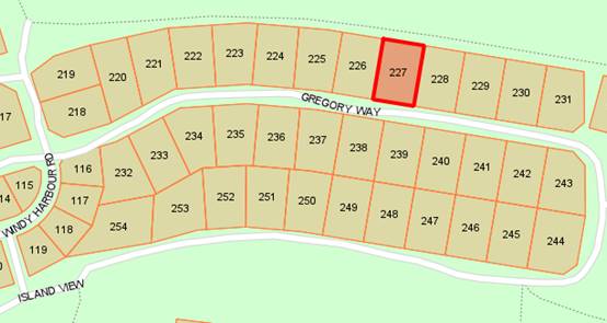
Councillor Taylor declared a Financial Interest in this Item as site 227 is opposite Site 238 that I am the leaseholder of. Councillor Taylor did not speak or vote on the matter and left the Chamber at 6.33pm.
9.3.2 Proposed Windy Harbour Lease Transfer - Site 227
|
PROPONENT |
KD, CA, AG, EW, GD, TD & DP Liddelow |
|
OWNER |
Crown (Management Order to Shire) |
|
LOCATION / ADDRESS: |
Site 227 Gregory Way, Windy Harbour |
|
WARD: |
Coastal |
|
ZONE: |
Special Use Zone No 5 |
|
DIRECTORATE: |
Business |
|
FILE REFERENCE: |
F180104 |
|
LEGISLATION: |
Local Government Act 1995 Land Administration Act 1997 |
|
AUTHOR: |
Jasmine Bamess |
|
DATE OF REPORT: |
6 March 2018 |
|
DECLARATION OF INTEREST: |
Nil |
Background:
The Shire of Manjimup has the Management Order for Reserve 38881 Windy Harbour for the purpose of “Recreation, Camping, Caravan Park and Holiday Cottages” with the power to lease, subject to the consent of the Minister for Lands. Since 2001 Council has been granting 20 year leases for designated lease sites.
Terry Liddelow has requested to transfer his share of the lease for Site 227 to the remaining six leaseholders.
PUBLIC Consultation Undertaken:
Nil
COMMENT (Includes Options):
In accordance with Policy 3.4.2 a general condition assessment for each lease site is to be undertaken once every five years and work orders issued where required. A general condition assessment for Site 227 was undertaken in 2016 with it being in an overall satisfactory condition.
The existing 20 year lease has an expiry date of 6 August 2028. The request is to effect the change by a Transfer with no change to the existing lease term. There are currently seven leaseholders as tenants in common of equal shares, accordingly this will become one sixth share each.
STATUTORY ENVIRONMENT:
A transfer/assignment of an existing lease does not constitute a ‘disposition of property’ from the Local Government’s point of view. Windy Harbour leases are also considered residential and therefore exempt from s3.58 (Disposing of Property) of the Local Government Act 1995 under s30(2)(g) of the Local Government (Functions and General) Regulations 1996.
Each lease and any subsequent transfers must receive the approval of the Minister for Lands in accordance with section 18 of the Land Administration Act 1997.
Policy / Strategic Implications:
The lease transfer and granting a new 20 year term is in accord with Council Policy 3.4.2 Windy Harbour Leases.
Organisational risk management:
Nil
Financial Implications:
Leaseholders are required to pay Council’s lease preparation fee to offset the administration costs of preparing and lodging each lease, lease surrender or lease transfer.
Sustainability:
Environmental: Nil
Economic: Nil
Social: Nil
VOTING REQUIREMENTS: SIMPLE MAJORITY
Officer Recommendation:
That Council consent to the transfer of a one seventh share of the existing Lease over Site 227 Windy Harbour from Terry Douglas Liddelow to Keith Donald Liddelow, Cheryl Ann Liddelow, Alan Gregory Liddelow, Esma Winifred Liddelow, Gary David Liddelow and Derek Philip Liddelow as tenants in common of equal shares, subject to approval of the Minister for Lands.
|
Moved: Daubney, L Seconded: Salomone, J
That Council consent to the transfer of a one seventh share of the existing Lease over Site 227 Windy Harbour from Terry Douglas Liddelow to Keith Donald Liddelow, Cheryl Ann Liddelow, Alan Gregory Liddelow, Esma Winifred Liddelow, Gary David Liddelow and Derek Philip Liddelow as tenants in common of equal shares, subject to approval of the Minister for Lands. CARRIED: 8/0 |
23
Councillor Taylor returned to the Chamber at 6.33pm.
ATTACHMENT
9.3.3 Council Financial Payments January 2018
|
PROPONENT |
Shire of Manjimup |
|
OWNER |
N/A |
|
LOCATION / ADDRESS: |
Whole of Shire |
|
WARD: |
All |
|
ZONE: |
Whole of Shire |
|
DIRECTORATE: |
Business |
|
FILE REFERENCE: |
F160967 |
|
LEGISLATION: |
Local Government (Financial Management) Regulations 1996 |
|
AUTHOR: |
Kaylee Blee |
|
DATE OF REPORT: |
8 March 2018 |
|
DECLARATION OF INTEREST: |
Nil |
Background:
It is a statutory requirement for a list of payments from the Municipal and Trust Funds to be presented to Council and included in the Minutes.
PUBLIC Consultation Undertaken:
Nil
COMMENT (Includes Options):
The accounts for payment totalling $3,361,540.28 for the month of January 2018 are itemised in the attachment and in the Corporate Card statement listed below.
ATTACHMENT: 9.3.3(1)
Vouchers for the expenditure are available for inspection at the Council Meeting of 22 March 2018.
|
Fund |
Vouchers |
Amount |
|
Municipal |
90813 - 90890 |
$202,863.51 |
|
Trust Fund |
- |
$0 |
|
Total Cheques for Month of January 2018 |
$202,863.51 |
|
Electronic Funds Transfer (EFT) expenditure batch reports are available for inspection at the Council Meeting of 22 March 2018
|
Fund |
Batch |
Amount |
|
Municipal |
342 – 352 |
$3,154,586.09 |
|
Total EFT for Month of January 2018 |
$3,154,586.09 |
|
Corporate Credit Card January 2018 – Municipal Account
|
43.4000.350.50 |
DWER – Water Clearing Permit - Windy Harbour Rd, NCF |
$50.00 |
|
|
20049.196.57 |
Kindred Nominees Boyanup CEO lunch - SW CEO’s Meeting |
$28.00 |
|
|
87.4999.7339.52 |
James the Jewellers 25yrs Service Gift for Todd Ridley |
$204.00 |
|
|
20049.197.57 |
SQ *Southern Roasting Refreshments CEO/SP meeting with WALGA |
$28.00 |
|
|
86.4999.6405.57 |
Adobe Creative Cloud Creative Cloud CS7 Suite - PRO |
$74.76 |
|
|
99999.908.99 |
Westnet Internet Services 1/1/18 – 1/2/18 |
$850.09 |
|
|
20027.29.52 |
Local Government Managers LG Professionals Finance Conference - DB |
$1320.00 |
|
|
92.9007.3240.57 |
Slimline Warehouse Portable Lectern |
$333.53 |
|
|
66.4999.7300.57 |
Adobe Creative Cloud Monthly Creative Cloud Subscription - CAO |
$74.76 |
|
|
87.4999.6625.52 |
CPFS – WWCSU Working with Children Check - CDO |
$84.00 |
|
|
712.1605.2867.58 |
City of Subiaco Parking – Interp site tour – Timber park project |
$5.80 |
|
|
20221.1007.58 |
Lombard Pty Ltd Display Merchandise/Decorations QBR |
$744.92 |
|
|
712.1605.2867.58 |
T & T Trade Pty Ltd Interp site tour – Timber park project ST:1 V:1 |
$50.50 |
|
|
712.1605.2867.58 |
Dome Armadale Interp site tour – Timber park project ST:1 V:1 |
$18.70 |
|
|
20020.3.57 |
STK*Shutterstock.com Images for advertising 365 days on demand |
$55.51 |
|
|
20387.279.57 |
EB *South West Early Years General Admission – SW Early Years Forum |
$25.00 |
|
|
85.4220.2044.57 |
WEX Australia (Coles) Groceries & Equipment for MRAC café |
$51.81 |
|
|
20049.197.57 |
Patricia Ann Keegan (Bello Torta) SMT Meals/Refreshments ST:6 |
$91.30 |
|
|
Total Credit Card Payments |
$4,090.68 |
||
|
Total Payments for the month January 2018 |
$3,361,540.28 |
||
STATUTORY ENVIRONMENT:
Local Government (Financial Management) Regulations 1996, Regulations (12) and (13)
Policy / Strategic Implications:
Nil
Organisational risk management:
Nil
Financial Implications:
As Stated
Sustainability:
Environmental: Nil
Economic: Nil
Social: Nil
VOTING REQUIREMENTS: SIMPLE MAJORITY
Officer Recommendation:
That Council receive the accounts paid during January 2018 totalling $3,361,540.28 as detailed in Corporate Card Statement and Attachment: 9.3.1(1).
|
Moved: Herbert, V Seconded: Ventris, M
That Council receive the accounts paid during January 2018 totalling $3,361,540.28 as detailed in Corporate Card Statement and Attachment: 9.3.1(1).
CARRIED: 9/0 |
26
9.3.4 Monthly Financial Activity Statement - January 2018
|
PROPONENT |
Shire of Manjimup |
|
OWNER |
Whole Shire |
|
LOCATION / ADDRESS: |
Whole Shire |
|
WARD: |
Whole Shire |
|
ZONE: |
N/A |
|
DIRECTORATE: |
Business |
|
FILE REFERENCE: |
F160188 |
|
LEGISLATION: |
Local Government Act 1995; Local Government (Financial Management) Regulations 1996 |
|
AUTHOR: |
Greg Lockwood |
|
DATE OF REPORT: |
8/03/2018 |
|
DECLARATION OF INTEREST: |
Nil |
Background:
The Financial Management Regulations require monthly Financial Activity Statement reports to be prepared and presented to Council, containing the following information;
ü Annual budget estimates;
ü Estimates to end of month;
ü Actual expenditure;
ü Actual income;
ü Material variances; and
ü Net current assets.
The Financial Activity Statement report for the period to 31 January 2018 is attached. The report is summarised by Function/Activity with operating comments via department.
ATTACHMENT: 9.3.4 (1)
PUBLIC Consultation Undertaken:
Nil
COMMENT (Includes Options):
The financial performance for the Shire of Manjimup to the 31 January 2018 is a projected deficit of $16,897.
The $16,897 deficit is a projection based on a conservative approach highlighting possible issues as they occur, which in most cases can be rectified or offset with under expenditure in other areas as the Shire progress through the financial year.
In brief the projected figures in most cases, assumes that the expenditure to 31 January 2018 continue at the same rate to 30 June 2018. Where an asterisks appears in the “Adj” column in the Management Reports, the formula has been changed to reflect the irregular purchase, or seasonal nature of that particular account. It should be noted that where a projected under expenditure might occur, the budgeted figure is still maintained.
January 2018 has continued the trend of no significant variances to report. Operational accounts are tracking generally on budget with some minor over expenditure that are expected to be offset by under expenditure. Below are two graphs reporting on Normal Operating Income and Expenditure.
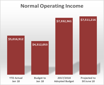
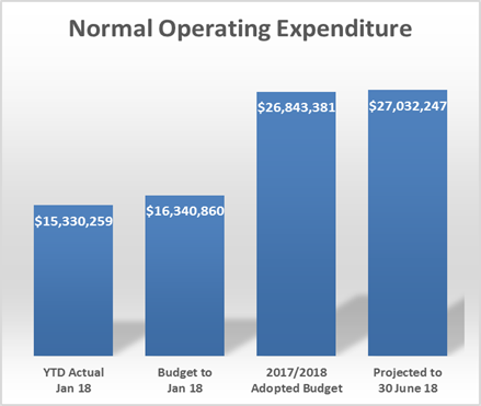
The 2 graphs demonstrate, that whilst there is a projection of extra Operating Income of $178,855, that projection is offset by additional operating expenditure of $188,866.
One of the positive income lines to date is the projection of an extra $50,000 of revenue for Tipping Fees for the Manjimup Refuse Site. If this income is realised at the 30 June 2018, it will be transferred to the Waste Management & Site Development Reserve for future development of waste sites.
Another area to comment on, that suggests good economic activity in the region, is the amount of Development Application Fees being received to date. Both Building Fees and Planning Fees are tracking close to the year to date budget and are projected to meet budget by the 30 June 2018. This trend has continued from a strong 2016/17 financial year which was off the back of some very quiet development years.
In summary there have been no major issues arise in the 7 months of 2017/18 and with sound financial management going forward by all departments, Council should be in a neutral or minor surplus position at the 30 June 2018.
STATUTORY ENVIRONMENT:
Section 6.8 Local Government Act and Financial Management Regulation 34.
Policy / Strategic Implications:
Nil
Organisational risk management:
Nil
Financial Implications:
As described in above summary.
Sustainability:
Environmental: Nil
Economic: Nil
Social: Nil
VOTING REQUIREMENTS: SIMPLE MAJORITY
Officer Recommendation:
That Council receive the Monthly Financial Activity Statement Report for January 2018 as per Attachment: 9.3.4(1).
|
Moved: Herbert, V Seconded: Tapley, D
That Council receive the Monthly Financial Activity Statement Report for January 2018 as per Attachment: 9.3.4(1). CARRIED: 9/0 |
30
9.3.5 Proposed Change in Term of Self Supporting Loan 226 - Pemberton Golf Club
|
PROPONENT |
Pemberton Golf Club |
|
OWNER |
Pemberton Golf Club |
|
LOCATION / ADDRESS: |
184 Golf Links Road, Pemberton |
|
WARD: |
West |
|
ZONE: |
Clubs & Institutions |
|
DIRECTORATE: |
Business |
|
FILE REFERENCE: |
F180110 |
|
LEGISLATION: |
Local Government Act 1995 and Local Government (Financial Management) Regulations 1996 |
|
AUTHOR: |
Greg Lockwood |
|
DATE OF REPORT: |
9 March 2018 |
|
DECLARATION OF INTEREST: |
Nil |
Background:
As part of the 2017/2018 budget adoption process Council approved a $140,000 Self Supporting Loan to the Pemberton Golf Club for a 4 year term.
Pemberton Golf Club committee have requested that the Self Supporting Loan is taken over 15 years rather than the adopted 4 years.
The purpose of this agenda item, due to the change in terms, is to accept the change and give authorisation to the Chief Executive Officer to give Public Notice of the change as required in the Local Government (Financial Management) Regulations.
PUBLIC Consultation Undertaken:
Nil
COMMENT (Includes Options):
Shire Officers have had several meetings with the Pemberton Golf Club so as to make application to the Western Australian Treasury Corporation for the Self Supporting Loan to build their new Club House. During these meetings the Committee contemplated a more conservative approach to their loan requesting an additional 11 years, going from a 4 year term to 15 years.
Whilst the Committee through the application process have indicated they will receive significant income from cutting hay, potatoes, avocadoes and cattle sales, the Committee believes that the extension in terms of the loan will iron out any fluctuations in the market for their produce in the coming years.
The extension in loan terms will give comfort to the Committee if income generation is reduced, however the expectation is that the loan will be paid out in full, around the 10 year period.
STATUTORY ENVIRONMENT:
Local Government (Financial Management) Regulations 1996 20(2)
Policy / Strategic Implications:
Policy 4.1.2 Self Supporting Loans
Corporate Business Plan – Theme “Our Infrastructure” – Assist communities to build and maintain sport and recreation facilities whilst encouraging co-locations, collaborations and resource sharing wherever possible.
Organisational risk management:
Pemberton Golf Club have provided all financial documentation to support the loan application to this point. Information supplied shows a diverse income generation portfolio that can easily fund the annual repayments required by the Pemberton Golf Club.
Financial Implications:
There are is no additional financial implications with extending the term of the Self Supporting Loan from 4 years to 15 years, however the increased term may influence future borrowing capacity of the Shire of Manjimup, as the Loan is considered a liability to the Shire of Manjimup rather than to the Pemberton Golf Club.
Sustainability:
Environmental: Nil
Economic: Nil
Social: Nil
VOTING REQUIREMENTS: ABSOLUTE MAJORITY
Officer Recommendation:
That Council approve the extension in Self Supporting Loan terms for the Pemberton Golf Club from 4 years to 15 years and authorise the Chief Executive Officer to give Public Notice of the change.
|
Moved: Ventris, M Seconded: Salomone, J
That Council approve the extension in Self Supporting Loan terms for the Pemberton Golf Club from 4 years to 15 years and authorise the Chief Executive Officer to give Public Notice of the change. CARRIED: 9/0 |
32
9.5.1 Proposed Setback Variation for Dam at Lot 9164 Littlefair Road, Eastbrook
|
PROPONENT |
JW Omodei |
|
OWNER |
JW Omodei |
|
LOCATION / ADDRESS: |
Lot 9164 Littlefair Road, Eastbrook |
|
WARD: |
West |
|
ZONE: |
Priority Agriculture |
|
DIRECTORATE: |
Development and Regulation |
|
FILE REFERENCE: |
P55282, DA18/6 |
|
LEGISLATION: |
Planning and Development Act 2005, Shire of Manjimup Local Planning Scheme No.4. |
|
AUTHOR: |
Jason Giadresco |
|
DATE OF REPORT: |
2 March 2018 |
|
DECLARATION OF INTEREST: |
Nil |
Background:
The 33.5ha subject property is located 9 kilometres north of the Pemberton townsite on the eastern side of Littlefair Road. A Location Plan depicting the proposed development is provided below.
Location Plan
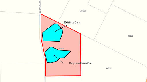
Currently the property is utilised for agricultural production, serviced by an existing dam with an approximate surface area of 5.4 ha. This existing dam is setback less than 10 metres from Littlefair Road.
Approval is now being sought to the construction of a second dam, increasing the water available for horticultural operations on the property. Site and Development Plans are attached.
ATTACHMENT: 9.5.1(1)
As detailed in the application it is proposed to construct a dam with a capacity of 130,862 cubic metres to service the onsite horticultural operations. To facilitate this, it is proposed a 220m long, 8m high dam wall be constructed 10m from the property boundary with Littlefair Road.
If approved, the dam will have a maximum depth of 7m and will extend approximately 320m east of the dam wall. Details submitted with the application indicate that the proposed dam wall will be covered in topsoil and will be re-seeded to stabilise the dam banks. Construction of the dam will require some existing vegetation to be removed.
Council is requested to determine the application given a relaxation of the front setback is being sought.
PUBLIC Consultation Undertaken:
The application was advertised in accordance with clause 9.6 of the Scheme for a 21 day period to the affected adjoining landowners and the Department of Water and Environment Regulation (DWER). One submission was received from DWER, raising no objection to the proposal, although offering some comment. A copy of the submission is attached.
ATTACHMENT: 9.5.1(2)
COMMENT (Includes Options):
As outlined by clause 8.4 (xxiv) of the Shire of Manjimup Local Planning Scheme No.4 (the Scheme), the establishment of a dam does not require prior development approval, provided that the application complies with the following:
(a) Has been approved or does not require approval from any State Government agency or authority; and
(b) The lower edge of the dam wall, and any other part of the dam including the stored water is further than 20 metres from the boundary of the subject lot.
In this case, prior planning consent is required given that the dam when constructed will be less than 20 metres to the boundary. To guide Council in the determination of the application the following comments are offered:
Matters to be considered
Clause 10.2 of the Scheme requires that in determining applications for development approval, the local government is required to have regard to various matters, including but not limited to:
(i) the aims and provisions of the Scheme and any other relevant Local Planning Scheme operating within the Scheme area;
(vi) the local governments adopted Local Planning Strategy and any Local Planning Policy adopted by the local government under clause 2.4;
(x) the compatibility of a use or development with its setting, including the potential impact on the use and enjoyment of adjacent and nearby land and taking into consideration any Special Control area;
(xxvi) the comments or submissions received from any authority that has been consulted;
(xiv) whether the land to which the application relates is unsuitable for the proposal by reason of it being, or being likely to be, subject to flooding, tidal inundation, subsidence, landslip, bush fire or any other risk;
The application as submitted is consistent with the aims of the Scheme in that the land is identified as Priority Agricultural land and the resultant development will be used to support horticultural activities as provided by the applicant.
The balance of the criteria highlighted above are addressed below.
Policy Compliance
Adopted Local Planning Policy LPS4 6.1.11 – Rural Land Uses (the Policy) to provide guidance and ensure a consistent approach is taken when considering applications.
An assessment of the application against the policy provisions relating to dam construction confirms that the application complies with all requirements, with the exception of the required setbacks to the eastern boundary with Littlefair Road reserve.
Shire Officers have assessed the dam against the provisions of the Policy and are satisfied that the dam is proposed to be used for a bona fide agricultural purpose. The proposed dam will have a visual impact on Littlefair Road and upon further inspection of the area, there are several dams within the vicinity that are located on the boundary with some or no screening supplied.
Scheme Requirements
The Scheme exempts development approval of all dams that are located a minimum of 20m from any property boundary on land zoned Priority Agriculture and General Agriculture. In this case, the dam is proposed to be located less than 20m from the eastern property boundary and hence requires planning approval to be granted.
The Scheme and supporting Policy do not automatically prohibit a dam from being located closer than 20m to a property boundary. Rather, it is intended that development approval be sought and granted where a reduced setback is being sought given the potential for impact upon adjoining land.
Drainage and Potential Impact on Littlefair Road
In accordance with the Shires Technical Services Policy 9.1 – Engineering construction standards for Development Applications, proposals within rural areas must comply with the following:
‘Drainage must be dealt with on site, include retention and management to prevent erosion. With approval from the Manager of Technical Services stormwater run-off may be directed into Council’s roadside stormwater drains’.
Given the reduced setback to Littlefair Road there is a concern that drainage runoff from the dam may impact on the integrity of the road reserve adjacent to the dam. Little detail is provided within the application as to how drainage impacts are to be managed. In order to protect the integrity of the Shire’s road asset and the travelling public using Littlefair Road, it is recommended that a condition and an associated advice note be imposed, requesting the applicant provide further detail on the spillway and drainage system of the dam to the satisfaction of the Chief Executive Officer.
Risk/Structural Integrity
When considering an application for planning approval, clause 10.2 of the Scheme also requires the local government to consider whether the land is unsuitable for the proposal “by reason of it being, or likely to be, subject to flooding, tidal inundation, subsidence, landslip, bush fire or any other risk”.
In this case, data held by the Shire indicates that the proposed dam is an on-stream dam, to be located at the juncture of two streams, in relative close proximity to the Shire road reserve. Due care should therefore be taken to ensure that the Dam structure and spillways are designed so as to avoid any issues that may arise in association with a major weather event.
It is considered in the Shire’s interest to recommend to the landowner a civil/structural engineer should be employed to ensure the integrity of the dam wall. It is recommended that advice notes to that effect be included on any approval issued by Council.
DWER Advice
The submission by DWER provides no objection to the dam as proposed and advises that a licence to clear vegetation to facilitate the development of the dam has been approved by the department. DWER further advise that an application to take surface water and interfere with bed and banks is currently lodged with the department, but would be subject to Council granting approval for this development.
In light of the above, an advice note requesting the applicant to contact DWER’s Manjimup Office to finalise any further approvals required is recommended to be included on any approval granted by Council.
Conclusion
If the dam was to be setback 20m from all boundaries, the Shires prior development consent would not be required. Given Council’s ability to impose conditions designed to protect the amenity of adjoining properties and the road reserve, the conditional approval of this application is not anticipated to have a detrimental effect on the locality.
STATUTORY ENVIRONMENT:
Clause 5.5.1 of the Scheme permits Council to approve a development despite non-compliance with identified standards. It is therefore open to Council vary the required setbacks prescribed in clause 8.4 (xxiv) and approve the application unconditionally, or subject to such conditions as it thinks fit.
It must however be noted that the discretion conferred by clause 5.5.1 may only be exercised if the local government is satisfied that:
(i) Approval of the proposed development would be appropriate have regard to the criteria set out in clause 10.2; and
(ii) The non-compliance will not have an adverse effect upon the occupiers or users of the development, the inhabitants of the locality of the likely future development of the locality.
Should Council resolve to grant approval to the proposal, the proponents will then be required to obtain all necessary agency licences approvals.
Policy / Strategic Implications:
Nil.
Organisational risk management:
Nil.
Financial Implications:
Nil.
Sustainability:
Environmental: Nil.
Economic: Approval to the application will ensure that a suitable water source is established and maintained to support expanding horticultural operations on the property. Approval to the application would therefore be consistent with Strategy B1 of the Shire’s Community Strategic Plan being to “Support sustainable agricultural expansion..”
Social: Nil.
VOTING REQUIREMENTS: SIMPLE MAJORITY
Officer Recommendation:
That Council:
1. In accordance with Part 10 and clause 5.5 of Shire of Manjimup Local Planning Scheme No.4 grant development approval to the application to construct a dam over Lot 9164 Littlefair Road, Eastbrook (Application TP 5/2018) subject to the following conditions and advice:
a) The development hereby approved must be carried out generally in accordance with the plans and specifications submitted with the application and these shall not be altered and/or modified without the prior knowledge and written consent from the Shire of Manjimup;
b) All stormwater and drainage runoff associated with the proposal hereby approved, is to be retained on the subject property or be provided with stormwater drainage connections to the Shire’s drainage system in the area at the developers cost to the satisfaction to the Shire of Manjimup;
c) All pumps and ancillary equipment and structures being setback from property boundaries in accordance with the requirements of Shire of Manjimup Local Planning Scheme No.4; and
d) Prior to the commencement of dam construction, the applicant is to provide construction details of the overflow infrastructure and the method to be used to discharge any associated drainage to Littlefair Road. Such details are to be to the satisfaction of the Shire of Manjimup in accordance with Technical Services Policy 9.1.
2. Advises the Applicant:
a) It is recommended that the design of the dam wall is certified by a practicing civil/structural engineer to ensure that it will be structurally sound.
b) It is the responsibility of the landowner to ensure that the dam is safely constructed and maintained;
c) The landowner may be liable for any damage caused as a result of any drainage/overflow from the dam impacting on infrastructure located within the Littlefair Road road reserve;
d) With regards to the condition stated at clause 1(d) above, the applicant is requested to contact the Shire’s Technical Services Department for further advice;
e) To contact the Department of Water and Environmental Regulation’s Manjimup Office on (08) 9771 1878 to obtain any approvals or licences required to facilitate construction of the dam.
|
Moved: Herbert, V
That Council: 1. In accordance with Part 10 and clause 5.5 of Shire of Manjimup Local Planning Scheme No.4 grant development approval to the application to construct a dam over Lot 9164 Littlefair Road, Eastbrook (Application TP 5/2018) subject to the following conditions and advice: a) The development hereby approved must be carried out generally in accordance with the plans and specifications submitted with the application and these shall not be altered and/or modified without the prior knowledge and written consent from the Shire of Manjimup; b) All stormwater and drainage runoff associated with the proposal hereby approved, is to be retained on the subject property or be provided with stormwater drainage connections to the Shire’s drainage system in the area at the developers cost to the satisfaction to the Shire of Manjimup; c) All pumps and ancillary equipment and structures being setback from property boundaries in accordance with the requirements of Shire of Manjimup Local Planning Scheme No.4; and d) Prior to the commencement of dam construction, the applicant is to provide construction details of the overflow infrastructure and the method to be used to discharge any associated drainage to Littlefair Road. Such details are to be to the satisfaction of the Shire of Manjimup in accordance with Technical Services Policy 9.1. e) It is recommended that the design of the dam wall is certified by a practicing civil/structural engineer to ensure that it will be structurally sound. 2. Advises the Applicant: a) It is the responsibility of the landowner to ensure that the dam is safely constructed and maintained; b) The landowner may be liable for any damage caused as a result of any drainage/overflow from the dam impacting on infrastructure located within the Littlefair Road road reserve; c) With regards to the condition stated at clause 1(d) above, the applicant is requested to contact the Shire’s Technical Services Department for further advice; d) To contact the Department of Water and Environmental Regulation’s Manjimup Office on (08) 9771 1878 to obtain any approvals or licences required to facilitate construction of the dam. Motion Lost due to no Seconder.
Moved: Daubney, L Seconded: Jenkins, D
That Council: 1. In accordance with Part 10 and clause 5.5 of Shire of Manjimup Local Planning Scheme No.4 grant development approval to the application to construct a dam over Lot 9164 Littlefair Road, Eastbrook (Application TP 5/2018) subject to the following conditions and advice: a) The development hereby approved must be carried out generally in accordance with the plans and specifications submitted with the application and these shall not be altered and/or modified without the prior knowledge and written consent from the Shire of Manjimup; b) All stormwater and drainage runoff associated with the proposal hereby approved, is to be retained on the subject property or be provided with stormwater drainage connections to the Shire’s drainage system in the area at the developers cost to the satisfaction to the Shire of Manjimup; c) All pumps and ancillary equipment and structures being setback from property boundaries in accordance with the requirements of Shire of Manjimup Local Planning Scheme No.4; and d) Prior to the commencement of dam construction, the applicant is to provide construction details of the overflow infrastructure and the method to be used to discharge any associated drainage to Littlefair Road. Such details are to be to the satisfaction of the Shire of Manjimup in accordance with Technical Services Policy 9.1. 2. Advises the Applicant: a) It is recommended that the design of the dam wall is certified by a practicing civil/structural engineer to ensure that it will be structurally sound. b) It is the responsibility of the landowner to ensure that the dam is safely constructed and maintained; c) The landowner may be liable for any damage caused as a result of any drainage/overflow from the dam impacting on infrastructure located within the Littlefair Road road reserve; d) With regards to the condition stated at clause 1(d) above, the applicant is requested to contact the Shire’s Technical Services Department for further advice; e) To contact the Department of Water and Environmental Regulation’s Manjimup Office on (08) 9771 1878 to obtain any approvals or licences required to facilitate construction of the dam. MOTION carried 8/1
|
40
9.5.2 Proposed Plantation at Location 3792 Lefroy Road & Location 3811 Peppermint Grove Road, Smith Brook
|
PROPONENT |
WA Plantation Resources |
|
OWNER |
Woodrakarra Pty Ltd |
|
LOCATION / ADDRESS: |
Location 3792 Lefroy Road & Location 3811 Peppermint Grove Road, Smith Brook |
|
WARD: |
East |
|
ZONE: |
Priority Agriculture |
|
DIRECTORATE: |
Development and Regulation |
|
FILE REFERENCE: |
DA18/5 P50840, P50841, P50843 |
|
LEGISLATION: |
Planning and Development Act 2005, Shire of Manjimup Local Planning Scheme No.4 |
|
AUTHOR: |
Jason Giadresco |
|
DATE OF REPORT: |
7 March 2018 |
|
DECLARATION OF INTEREST: |
Nil |
Background:
The subject properties have a collective area of 265.7ha and are located 13km south-east of the Manjimup townsite. The properties are surrounded by rural land and State Forest to the west.
Location Plan

In May 1997, the Shire granted conditional approval to a two rotation Tasmanian Blue-Gum (Eucalyptus globulus) plantation over the subject land. With harvesting of the second rotation being completed recently, the applicants are seeking approval to establish new crop over the two properties.
The 136ha plantation will be separated into 9 sectors sized between 0.8ha and 29.3ha largely across Location 3811. The sectors to be re-established are generally the same as those recently harvested with all onsite road infrastructure and firebreaks remaining as is. Location 3972 was replanted in 2008, but will provide an access point into the plantation area. Two sections of remnant native vegetation with a combined area of 18ha will remain on Location 3811.
The land currently contains a shed on Location 3811 and four small dams scattered throughout the plantation area. A dwelling and shed are located on Location 3972. The Plantation is proposed over the majority of the subject properties other than that accommodated by native vegetation, waterways and wet areas. Site and Plantation Management Plans are attached.
ATTACHMENT: 9.5.2(1)
Council is requested to determine the application given that a Plantation is considered a discretionary land use by the Scheme.
PUBLIC Consultation Undertaken:
The application was advertised in accordance with clause 9.6 of the Scheme for a 21 day period. Correspondence was forwarded to neighbouring landowners, Department of Fire and Emergency Services (DFES) Department of Water and Environment Regulation (DWER), Department of Biodiversity, Conservation and Attractions (DBCA) and Main Roads Western Australia (MRWA).
No submissions were received from adjoining landowners or MRWA. A copy of submissions received from DFES, DWER and DBCA are attached.
ATTACHMENT: 9.5.2(2)
COMMENT (Includes Options):
The provisions of the Shire of Manjimup’s Local Planning Scheme No.4 (the Scheme) includes the land within the Priority Agriculture Zone. The proposed use is classified under the Scheme as a Plantation, being an ‘A’ use within Priority Agricultural Zone. That is a use which is not permitted, unless Council has exercised its discretion by granting planning approval after publicly advertising the application in accordance with the requirements of clause 9.6 of the Scheme.
The Scheme defines as a “Plantation” as follows:
“A stand of trees of ten hectares, or larger, that has been established by sowing or planting of either native or exotic trees species selected and managed intensively for their commercial and/or environmental value. A plantation includes roads, tracks, firebreaks and small areas of native vegetation surrounded by plantations. Implicit in this definition is the recognition that the plantation will be harvested”.
The application has been assessed against Shire of Manjimup Local Planning Policy 6.1.11 Rural Land Uses (the Policy), DFES Guidelines for Plantation Fire Protection (the Guidelines) and the Forest Industries Federation of Western Australia’s Code of Practice for Tree Plantations (the Code of Practice) which are discussed below.
Access
Access to the proposed plantation under the Policy is required to be suitable and safe. In this instance the subject site fronts South West Highway, Peppermint Grove Road and Lefroy Road. Lefroy Road and South West Highway are proposed as the primary access roads to the properties. Peppermint Grove Road is not proposed to be utilised as an access road.
The application was forwarded onto MRWA as it is expected South West Highway will be utilised over the lifespan of the re-established Plantation. As stated within the Public Consultation section above, no comments have been received from MRWA.
In respect of access from Lefroy Road, being a Shire managed road, it is recommended that any approval include a condition to ensure the access is suitable and safe at the time of harvesting and the appropriate approvals are obtained from the Shire for the haulage routes prior to harvesting.
It is additionally recommended that a condition be imposed requiring the maintenance of Lefroy Road. This will ensure that the applicant is aware that they are responsible for, and are required to rectify, any proven damage to Lefroy Road and must maintain the life of the roads during the length of the harvesting operation, which is expected to commence in 2029.
Fire Management
The Fire Management Plan that forms part of the application is required to comply with the Guidelines and Code of Practice prepared by DFES and the Forest Industries Federation of WA for fire management respectively. Under the Guidelines the width of fire breaks, internal sector size, setback distances to dwellings and low fuel zones are stipulated. DFES offered no objection to the application subject to it being compliant with its Guidelines for Planning in Bushfire Prone Areas and State Planning Policy 3.7 Development in Bushfire Prone Areas.
Plantation Firebreaks and Sector Size
The application has proposed 15m wide external firebreaks along both the properties boundaries and 6m internal firebreaks between each sector. These firebreaks are deemed compliant with the Guidelines and Code of Practice as required by the Policy.
The Guidelines also stipulate that the area of each compartment within the proposed plantation is not to exceed 30 hectares in size. As the proposed four compartments as indicated above are no larger than 26 hectares in size. The proposed Plantation complies with this requirement.
In the event Council approves the application, a condition requiring compliance with both the requirements of the Code of Practice and Guidelines will be included on any approval issued, and that all fire management measures listed in the Fire Management Plan are to be implemented on an ongoing basis.
Availability of DBCA Fire Appliances
Within their submission, DBCA note that the Plantation Management Plan includes a statement that “the nearest Parks and Wildlife office is in Manjimup, and the next closest are in Pemberton”. DBCA state that no expectation that their fire-fighting resources will be available to combat a fire event on the property should be expected, and that the Department should not be referenced. In light of this comment, Shire officers recommend an appropriate condition be imposed requiring modification of the proposed Fire Management Plan to remove reference to DBCA fire fighting resources.
Adjacent Infrastructure
In relation to existing infrastructure the proposed plantation is required to be setback 50 metres from all the dwellings and outbuildings located on the subject site or on neighbouring properties. The subject site contains a dwelling and two sheds.
Whilst the dwelling is setback over 50m in all directions to the existing Plantation, the shed on Location 3811 is setback approximately 10m from the proposed Plantation area. In the event that the plantation is approved, it is recommended that a condition requiring the plantation to be setback from the shed in accordance with the Guidelines be included on any approval issued by Council. This ensures that should the shed be used, the standard setback requirements are applied.
It is also noted that there are dwellings and associated outbuildings located on the adjoining properties to the north and south. The setback distance to these buildings from the Plantation is over 100 metres in each instance. This exceeds the 50 metre setback and 50 metre low fuel zone requirement of the Guidelines.
Impacts on Water Resources
In order to reduce potential impacts on waterways within tree plantations, the Policy requires a setback distance of 6m either side of the water course. As the applicant has not stated that the Plantation will be setback to the four dams on the property, Shire Officers recommend that a condition requiring compliance with the 6m setback.
The advice provided from DWER provided no objection to the application. DWER notes that this proposal is for a third rotation establishment of a Plantation (E. globulus); and no clearing of native vegetation is proposed as all the plantation area has been established through previous rotations. The proposal is located within the Warren River and Tributaries Surface Water Area as proclaimed under the Rights in Water and Irrigation Act (RIWI) 1914. It is also within ‘Zone C’ of the Country Areas Water Supply Act Area 1947, where native vegetation clearing restrictions apply.
DWER’s available aerial imagery shows a waterway network (also shown on the plan submitted by the applicant) and an on-stream dam adjacent to Peppermint Grove Road, and note that the required 6m buffer to any waterway has not been maintained. The Department also identifies risks in potential for erosion, sediment transport and turbidity if operational activities intercept the waterway riparian zone and a possible detrimental impact on water quality (pesticides, herbicides and other chemicals) for licenced users downstream.
To mitigate these potential risks, DWER recommends that:
· The waterway riparian zone should be determined based on aerial imagery, landform (seasonal banks), and contours.
· A non-planted buffer of at least six meters should be maintained from the edge of a watercourse; and a separate allowance made for machine operations (during site preparation and harvesting) to ensure that the 6 metre non-planted buffer remains undisturbed.
· The taking of surface water to support the commercial operation may require a licence/permit from the Department under the RIWI Act 1914, and the proponent is therefore advised to contact the Department’s Manjimup licensing branch.
Conditions and advice reflecting the risk mitigation recommendations made by DWER and compliance with the Policy are recommended for any approval issued by Council.
Visual Impact
In accordance with the Policy, key locations with high visual aesthetic have been identified around each settlement (Northcliffe, Pemberton, Manjimup and Walpole) area that are located around or near designated regional roads. Applications for plantations within these locations are required to be assessed in regard to their visual impact from these regional roads, being major tourist routes within the Shire.
The subject site is not located within an identified area and therefore the Plantation complies with this aspect of the Policy.
Adjoining Land Uses
The subject properties are bound by agricultural properties on all boundaries. From an assessment of the site it appears that these properties contain buildings such as a dwelling and associated outbuildings. The surrounding properties are generally pastured lots and contain some remnant stands of native vegetation. Large areas of State Forest managed by DBCA are located to the west and south-east of the site.
The submission provided by DBCA requests that suitable fire protection measures are in place for the safety of the Plantation without dependence on the management provisions of adjacent DBCA managed land, and fire protection should be undertaken on the site. As illustrated within the ‘Fire Management’ section above, the applicant will be installing 15m wide firebreaks on boundaries, and 10m wide internal firebreaks between sections to comply with the Guidelines, as well as undertake a variety of onsite mitigation measures. A condition ensuring compliance with the Fire Management Plan is recommended to be included on any approval issued by Council.
DBCA also advises that if any native vegetation is to be removed as part of the proposal, DWER should be consulted to determine compliance with native vegetation clearing regulations. Whilst it is not proposed to remove any native vegetation, an advice note to this effect, as discussed above, will be included on any approval issued by Council.
Conclusion
Given the above, it is recommended that the application be approved subject to standard conditions in addition to those discussed in the report.
STATUTORY ENVIRONMENT:
Planning and Development Act 2005 and Shire of Manjimup Local Planning Scheme No. 4.
Policy / Strategic Implications:
The relationship of this application to the current Policy and the environment is discussed in the comment section.
Organisational risk management:
Nil.
Financial Implications:
The required Planning Application fee has been paid by the Applicant.
Sustainability:
Environmental: In this instance it is considered that the proposed plantation may produce a positive natural resource management outcome in the surrounding area as the subject application is not proposing to impact upon the existing waterway nor requires the removal of native vegetation to enable its establishment.
Economic: The application if approved will contribute to the area’s timber products industry and will continue to diversify the economy by providing employment opportunities within the Shire.
Social: As addressed in the comment section above it is considered that the adjoining land uses are compatible with the proposed Plantation. Therefore it is considered that there are no social implications as a result of the proposed plantation.
VOTING REQUIREMENTS: SIMPLE MAJORITY
Officer Recommendation:
That Council:
1. In accordance with Part 10 of Shire of Manjimup Local Planning Scheme No.4 grants planning approval for a Plantation (Eucalyptus Globulus) at Location 3972 Lefroy Road and Location 3811 Peppermint Grove Road, Smith Brook in accordance with the submitted plans and specifications and subject to the following conditions:
a) Prior to commencement of the use hereby approved, the submitted Fire Management Plan shall be modified to remove reference to Department of Biodiversity, Conservation and Attractions fire fighting resources.
b) Prior to commencement of the use hereby approved, plans submitted with the application shall be modified to address the following matters to the satisfaction of the Chief Executive Officer:
i. Identification of the waterway network adjacent to the eastern boundary as identified by the Department of Water and Environmental Regulation;
ii. Identification of the waterway riparian zone, based on aerial imagery, landform (seasonal banks) and contours.
iii. A minimum setback of 6 metres being maintained on either side of any water course or dam;
c) In conducting the activity hereby approved the plantation Operator/Manager is required to comply with all relevant legislation, and to have particular regard to the general and reasonable amenity expectations of those who may be resident in the vicinity to the satisfaction of the Shire of Manjimup;
d) A separate ‘Harvesting Plan’ is to be submitted to the local government a minimum of 24 months prior to the anticipated commencement of the harvesting of the subject plantation. Not less than 12 months prior to commencement of harvesting operations, formal notification of the intention to harvest shall be given to the local government. The ‘Harvesting Plan’ is to be prepared in accordance with the latest Code of Practice for Timber Plantations (or equivalent) that is applicable at that time and shall be to the satisfaction of the Shire of Manjimup;
e) Fire management measures outlined in the application are to be implemented in accordance with the approved Fire Management Plan and are to meet the performance standards outlined in the Guidelines for Plantation Fire Protection document to the satisfaction of the Shire of Manjimup; and
f) Any proven damage to Lefroy Road caused by vehicles associated with the approved Plantation is to be repaired at the applicant’s cost to the satisfaction of the Shire of Manjimup;
g) At the completion of any harvesting the area which has been harvested shall be reinstated to the requirements and satisfaction of the responsible authority. In particular:
i. All waste shall be disposed of to the satisfaction of the responsible authority and should not be placed in or near any water course;
ii. Any surplus tree branches shall be adequately disposed and shall not be left on site if they contribute to a fire hazard on the property; and
iii. All temporary roads shall be reinstated and left providing for adequate drainage and soil stability without the need for continuous maintenance.
2. Advises the Applicant:
a) Further to condition No 1 above, the applicant is advised that the Department of Biodiversity, Conservation and Attractions (DBCA) have advised that fire-fighting resources available to DBCA should not be expected to combat a fire event within the property for the lifetime of the Plantation.
b) That the operation of the Plantation including its harvest is required to comply with the ‘Environmental Protection (Noise) Regulations, 1997’.
c) That should clearance of native vegetation or taking of surface water occur on the subject properties, the Department of Water and Environment Regulation is to be contacted to determine the need for any approval.
|
Moved: Eiby, W Seconded: Salomone, J
That Council: 1. In accordance with Part 10 of Shire of Manjimup Local Planning Scheme No.4 grants planning approval for a Plantation (Eucalyptus Globulus) at Location 3972 Lefroy Road and Location 3811 Peppermint Grove Road, Smith Brook in accordance with the submitted plans and specifications and subject to the following conditions: a) Prior to commencement of the use hereby approved, the submitted Fire Management Plan shall be modified to remove reference to Department of Biodiversity, Conservation and Attractions fire fighting resources. b) Prior to commencement of the use hereby approved, plans submitted with the application shall be modified to address the following matters to the satisfaction of the Chief Executive Officer: i. Identification of the waterway network adjacent to the eastern boundary as identified by the Department of Water and Environmental Regulation; ii. Identification of the waterway riparian zone, based on aerial imagery, landform (seasonal banks) and contours. iii. A minimum setback of 6 metres being maintained on either side of any water course or dam; c) In conducting the activity hereby approved the plantation Operator/Manager is required to comply with all relevant legislation, and to have particular regard to the general and reasonable amenity expectations of those who may be resident in the vicinity to the satisfaction of the Shire of Manjimup; d) A separate ‘Harvesting Plan’ is to be submitted to the local government a minimum of 24 months prior to the anticipated commencement of the harvesting of the subject plantation. Not less than 12 months prior to commencement of harvesting operations, formal notification of the intention to harvest shall be given to the local government. The ‘Harvesting Plan’ is to be prepared in accordance with the latest Code of Practice for Timber Plantations (or equivalent) that is applicable at that time and shall be to the satisfaction of the Shire of Manjimup; e) Fire management measures outlined in the application are to be implemented in accordance with the approved Fire Management Plan and are to meet the performance standards outlined in the Guidelines for Plantation Fire Protection document to the satisfaction of the Shire of Manjimup; and f) Any proven damage to Lefroy Road caused by vehicles associated with the approved Plantation is to be repaired at the applicant’s cost to the satisfaction of the Shire of Manjimup; g) At the completion of any harvesting the area which has been harvested shall be reinstated to the requirements and satisfaction of the responsible authority. In particular: i. All waste shall be disposed of to the satisfaction of the responsible authority and should not be placed in or near any water course; ii. Any surplus tree branches shall be adequately disposed and shall not be left on site if they contribute to a fire hazard on the property; and iii. All temporary roads shall be reinstated and left providing for adequate drainage and soil stability without the need for continuous maintenance. 2. Advises the Applicant: a) Further to condition No 1 above, the applicant is advised that the Department of Biodiversity, Conservation and Attractions (DBCA) have advised that fire-fighting resources available to DBCA should not be expected to combat a fire event within the property for the lifetime of the Plantation. b) That the operation of the Plantation including its harvest is required to comply with the ‘Environmental Protection (Noise) Regulations, 1997’. c) That should clearance of native vegetation or taking of surface water occur on the subject properties, the Department of Water and Environment Regulation is to be contacted to determine the need for any approval. CARRIED: 9/0 |
50
9.5.3 Proposed Management Plan for Pioneer Park, Walpole
|
PROPONENT |
Shire of Manjimup |
|
OWNER |
Crown Land (Management Order to Conservation Commission of Western Australia) |
|
LOCATION / ADDRESS: |
Part Reserve 31362 South Western Hwy, Walpole |
|
WARD: |
South |
|
ZONE: |
Parks and Recreation |
|
DIRECTORATE: |
Development & Regulation |
|
FILE REFERENCE: |
F160263 |
|
LEGISLATION: |
Local Government Act 1995 & Conservation and Land Management Act 1984 |
|
AUTHOR: |
Brian Robinson |
|
DATE OF REPORT: |
8/03/2018 |
|
DECLARATION OF INTEREST: |
Nil |
Background:
Pioneer Park is a 22ha portion of Reserve 31362, located on the northern side of the South Western Highway within the Walpole Townsite. The Shire leases the area from the Conservation Commission of Western Australia.
The Shire in turn sub-leases the Walpole-Nornalup Visitors Centre building located within the reserve.
Whilst it is proposed that ultimately Pioneer Park will be excised from Reserve 31362 and vested directly with the Shire, the associated process is lengthy and complicated given that Reserve 31362 is an “A” class reserve.
At its meeting held on the 3 March 2016, Council endorsed a concept plan for the future development of Pioneer Park that had been prepared by the Walpole-Nornalup Visitors Centre. A copy of the endorsed Concept Plan is shown attached.
ATTACHMENT: 9.5.3(1)
Council is now requested to adopt, for the purposes of advertising, a Draft Management Plan that has been prepared using the endorsed concept plan as it base. A copy of the Draft Management Plan is shown at Attachment: 9.5.3(2).
ATTACHMENT: 9.5.3(2)
PUBLIC Consultation Undertaken:
Comments on the draft Management Plan, obtained from the Walpole Town Centre Revitalisation Committee have been used to refine the draft Management Plan.
Should Council endorse the Draft Management Plan, the plan will be advertised for public comment over a period of 30 days. Advertising will consist of signage being erected on site and advertisement within the local paper. A copy of the Draft Management Plan will also be referred to the following parties for comment:
· Walpole Town Centre Revitalisation Committee;
· The Walpole-Nornalup Visitors Centre;
· Main Roads Western Australia;
· Department of Biodiversity, Conservation and Attractions; and
· The Conservation Commission of Western Australia.
COMMENT (Includes Options):
The purpose of the draft Management Plan is to facilitate the future development and consolidation of Pioneer Park as a gateway to the Walpole Wilderness Area and an important driver rest stop, strategically located on the South Western Highway.
As reflected within Attachment: 9.5.3 (2), the aims and objectives of the Draft Management Plan are as follows:
a) To increase the use of Pioneer Park as a physical and educational gateway to the Walpole Wilderness Area and the region, by:
· Improving access to the Walpole-Nornalup Visitors Centre, including the installation of accessible pathways and access to the building for those persons with accessibility issues;
· Increasing the exposure of the Visitors Centre through appropriate signage and the selective clearing of trees located between the building and the South Western Highway;
· Ensuring that information regarding tourist attractions, both natural and built are kept up to date and conveyed to the public in a co-ordinated manner within the Park;
· Increasing the attractions for passing tourist traffic to stop and explore the park and region.
b) Increase the number and duration of tourist stops in Walpole, with particular reference to tourists transitioning between tourist attractions through:
· Improving external and internal signage relating to Pioneer Park and the Visitors Centre.
· Increasing the number and range of activities located within the Park;
· Improving vehicle and pedestrian access to the whole of Pioneer Park;
· Improvements to existing park infrastructure such as seating and shelters; and
· Continuation of Pioneer Park as the site of the Walpole Community Markets.
c) Recognise the role that Pioneer Park played in the settlement and development of the Walpole townsite and region and community aspirations for the park;
d) To clarify the role of the Shire and Walpole-Nornalup Visitors Centre in the development and management of the Pioneer Park.
e) To consolidate the use of the Park and a local passive recreation facility.
As reflected within the draft Management Plan, day to day management of the park will remain with the Shire of Manjimup.
STATUTORY ENVIRONMENT:
Local Government Act
Policy / Strategic Implications:
Adoption of a Management Plan for Pioneer Park will assist in guiding future development and use of the park and will be utilised to support future grant applications and guide future expenditure.
Organisational risk management:
Nil
Financial Implications:
All costs associated with advertising of the draft Management Plan will be wholly contained within the 2017/18 annual budget.
Funding to implement the recommendations contained within the Management Plan will be sourced through grant funding where available and the annual Shire Budget process
Sustainability:
Environmental: Nil
Economic: By increasing the use of Pioneer Park and encouraging increase use of the Walpole-Nornalup Visitors Center, Council would be supporting the local economy consistent with the Community Goals as outlined in Section 2 of the Shire of Manjimup Strategic Community Plan.
Social: Upgrading of the existing facilities to ensure that they are suitable for those persons with accessibility issues is consistent with the recommendations of the Shires Strategic Community Plan recommendations relating to Our Community.
VOTING REQUIREMENTS: SIMPLE MAJORITY
Officer Recommendation:
That:
1. Council adopt the Draft Management Plan for Pioneer Park as shown at Attachment: 9.5.3 (2) , for the purposes of advertising over a period of not less than 30 days;
2. A copy of the Draft Management Plan be forwarded to the following agencies for comment during the advertising period identified in point 1) above:
o Walpole Town Centre Revitalisation Committee;
o The Walpole-Nornalup Visitors Centre;
o Main Roads Western Australia;
o Department of Biodiversity, Conservation and Attractions; and
o The Conservation Commission of Western Australia; and
3. Await a further report on the Draft Management Plan following the close of advertising.
|
Moved: Tapley, D Seconded: Taylor, R
That: 1. Council adopt the Draft Management Plan for Pioneer Park as shown at Attachment: 9.5.3 (2) , for the purposes of advertising over a period of not less than 30 days; 2. A copy of the Draft Management Plan be forwarded to the following agencies for comment during the advertising period identified in point 1) above: o Walpole Town Centre Revitalisation Committee; o The Walpole-Nornalup Visitors Centre; o Main Roads Western Australia; o Department of Biodiversity, Conservation and Attractions; and o The Conservation Commission of Western Australia; and
3. Await a further report on the Draft Management Plan following the close of advertising. CARRIED: 9/0 |
54
9.5.4 Finalisation of Pemberton Heritage Study
|
PROPONENT |
Shire of Manjimup |
|
OWNER |
Various |
|
LOCATION / ADDRESS: |
Pemberton Timber Mill Workers Cottages Precinct |
|
WARD: |
West |
|
ZONE: |
Residential |
|
DIRECTORATE: |
Development & Regulation |
|
FILE REFERENCE: |
F161045 |
|
LEGISLATION: |
Heritage of Western Australia Act 1990 Planning and Development Act 2005 |
|
AUTHOR: |
Brian Robinson |
|
DATE OF REPORT: |
8/03/2018 |
|
DECLARATION OF INTEREST: |
Nil |
Background:
The Pemberton Timber Mill Workers’ Cottages Precinct is included on the State Register of Heritage Places. As shown on the location plan below, the precinct, which contains 58 houses and 3 other non-residential buildings, is bound by Brockman Street, Dean Street, Lefroy Street and Broadway Street.
Council is requested to consider endorsing the advertisement, for public comment, a Conservation Plan for the precinct that was prepared in 2013.
Location Plan
In order to guide development and management of heritage listed buildings, a Conservation Plan is normally prepared. A Conservation Plan documents the history and nature of a historic heritage place, assesses and records its cultural heritage significance and provides a framework (policy and strategy) for conserving its significant fabric and values.
At its Ordinary meeting held on 9 May 2013, Council was requested to consider a draft Conservation Plan for the precinct. Council adopted the Plan for the purposes of advertising. Council resolved to adopt the officer’s recommendation to:
1. Adopt the Conservation Management Plan for the purposes of advertising; and
2. Complete a comprehensive public consultation process.
Council is requested to consider this matter as it appears that whilst the plan was adopted for the purposes of advertising the Plan was never finalised.
PUBLIC Consultation Undertaken:
During preparation of the Conservation Plan, all property owners were advised that the Plan was being prepared. All owners were invited to discuss the project with the consultant team during the site inspections undertaken in September 2012.
COMMENT (Includes Options):
The provisions of the Shire’s Local Planning Scheme No 4 (LPS No 4) includes the majority of the land within the Residential Zone, with an identified residential density of R10.
LPS No 4 also includes the land within Pemberton Planning Precinct No 4 (Urban Centre) under Schedule 8. As reflected within clause 3.4 of Schedule 8, “The mill cottages from Dean Street to the Pemberton Karri Mill are typical timber-clad, corrugated iron roofed original cottages, characteristic of the timber industry. This historic node requires detailed planning to determine its future and the most realistic way of retaining where possible all of the cottages”.
Additionally due to its heritage value, the precinct is subject to a State Heritage listing. The heritage status of the Precinct is reflected within the Shire of Manjimup’s Municipal Heritage Inventory.
As a result the Shires prior planning approval is required for any development located within the precinct, including internal works. Furthermore comments on any proposed development must be sought from the Heritage Council of Western Australia prior to determination of the application.
Adoption of a Conservation Management Plan is highly recommended in order to provide guidance in respect of future development applications for both applicants and Shire Officers alike.
It should be noted that whilst the draft Conservation Management Plan for the Pemberton Mill Workers Cottages has not been finalised at this time, it appears that both Shire and Heritage Council of WA officers have been utilising the recommendations to guide development within the precinct. For example, retention of the current appearance as viewed from the street, with new development being encouraged to the rear.
STATUTORY ENVIRONMENT:
Planning and Development Act 2005 and Heritage Act 1990.
Within planning law, there is an established principal of ‘seriously entertained planning proposal’. In essence the provisions of a draft planning proposal can be considered when determining an application when it is:
· Based on sound planning principals;
· It is a public, rather than a secret policy;
· The length of time that it has been in operation; and
· It has been continuously supplied.
In this case, the contents of the draft Conservation Management Plan were prepared having regard to the Heritage significance of the site, the Shires Municipal Heritage Inventory. The plan is therefore based on sound planning principals. As the contents of the plan have been readily available to the public since May 2013 and officers from both the Shire and Heritage Council have consistently applied the plan recommendations, it is considered that the Conservation Management Plan is a seriously entertained planning proposal.
Given the above, it is Council is requested to endorse the continued use of the Conservation Management Plan to guide development within the Pemberton Mill Workers Cottages Precinct during the public consultation period.
Policy / Strategic Implications:
In accordance with Part 7 of LPS No 4, the Shire is obliged to establish and maintain a Heritage List to identify those places within the Scheme that are of cultural heritage significance. This list is included within Local Planning Policy No 6.1.13, being a Local Planning Policy prepared, advertised for public comment and adopted in accordance with clause 2.2 of LPS No 4.
The Heritage List attached to the above policy identifies the Pemberton Mill Workers Cottages precinct as having an A+ classification, being the highest heritage status available. As reflected within the Policy, the Shires prior planning approval is required for all development within the precinct.
In the event that the Conservation Plan is adopted after formal consultation, it is recommended that a Local Planning Policy be prepared to allow the design policies to be incorporated into Local Planning Scheme No.4.
Organisational risk management:
Nil
Financial Implications:
All costs associated with finalising the Conservation Plan will be wholly contained within the adopted 2017/18 annual budget.
Sustainability:
Environmental: Nil
Economic: The Conservation Plan is designed to streamline the planning approval process and provide property owners greater certainty on heritage requirements within the Precinct. This is expected to reduce costs associated with redrafting of plans and time delays.
Social: The Precinct has been identified as being a significant contributor to Pemberton’s ‘sense of place’ and community identify as an historic timber milling town. The Conservation Plan attempts to find the balance between community expectations that the Precinct will be preserved and the desire of residents to enjoy a modern standard of amenity.
VOTING REQUIREMENTS: SIMPLE MAJORITY
Officer Recommendation:
That Council
1. Endorses the use of the Conservation Plan for the Pemberton Mill Workers’ Cottages Precinct to guide development within the precinct on the basis that it is a seriously entertained planning proposal; and
2. Request that the Chief Executive Officer proceed with public consultation on the draft Conservation Plan for the Pemberton Mill Workers’ Cottages Precinct in accordance with the following principals, as adopted by Council at its Ordinary Meeting held on 9 May 2013:
a) Upload of the complete document to the Shire’s website with hard copies placed on display at the Manjimup Shire Office, Pemberton Library and Pemberton Community Resource Centre;
b) A Public Notice advising of the Conservation Plan and inviting comments being published within the two local newspapers relating to Pemberton;
c) An information leaflet outlining the key elements of the Conservation Plan and a copy of the individual place record for a property being provided to each property owner within the Precinct by post;
d) An informal ‘Q and A’ session being held in Pemberton during the submission period with attendance by Shire staff and the Shire’s Regional Heritage Advisor to allow for group or individual discussion with property owners;
e) A 42-day submission period being provided;
f) All written submissions being considered against the draft Conservation Plan with recommendations to Council on whether modifications are required; and
3. Await a further report on this matter following the completion of the consultation period.
|
Moved: Herbert, V Seconded: Eiby, W
That Council 1. Endorses the use of the Conservation Plan for the Pemberton Mill Workers’ Cottages Precinct to guide development within the precinct on the basis that it is a seriously entertained planning proposal; and 2. Request that the Chief Executive Officer proceed with public consultation on the draft Conservation Plan for the Pemberton Mill Workers’ Cottages Precinct in accordance with the following principals, as adopted by Council at its Ordinary Meeting held on 9 May 2013: a) Upload of the complete document to the Shire’s website with hard copies placed on display at the Manjimup Shire Office, Pemberton Library and Pemberton Community Resource Centre; b) A Public Notice advising of the Conservation Plan and inviting comments being published within the two local newspapers relating to Pemberton; c) An information leaflet outlining the key elements of the Conservation Plan and a copy of the individual place record for a property being provided to each property owner within the Precinct by post; d) An informal ‘Q and A’ session being held in Pemberton during the submission period with attendance by Shire staff and the Shire’s Regional Heritage Advisor to allow for group or individual discussion with property owners; e) A 42-day submission period being provided; f) All written submissions being considered against the draft Conservation Plan with recommendations to Council on whether modifications are required; and 3. Await a further report on this matter following the completion of the consultation period. CARRIED: 9/0 |
59
9.5.5 Proposed Works for Northcliffe Fire and Rescue Service and Northcliffe Bush Fire Brigade - No 10 (Lot 22) Banksia Street, Northcliffe
|
PROPONENT |
Shire of Manjimup & Department of Fire and Emergency Services |
|
OWNER |
Department of Fire and Emergency Services |
|
LOCATION / ADDRESS: |
No 10 (Lot 222) Banksia Street, Northcliffe |
|
WARD: |
Coastal Ward |
|
ZONE: |
Public Purposes |
|
DIRECTORATE: |
Development & Regulation |
|
FILE REFERENCE: |
F161206 & P55378 |
|
LEGISLATION: |
Local Government Act 1995 |
|
AUTHOR: |
Brian Robinson |
|
DATE OF REPORT: |
8/03/2018 |
|
DECLARATION OF INTEREST: |
Nil |
Background:
The Northcliffe Fire and Rescue Service and Northcliffe Bush Fire Brigade are co-located on the subject land, being a 2776m² lot located on the corner of Banksia Terrace and Meerup Street within the Northcliffe Townsite. A location plan is shown below:
Being responsible for the operation of the Bush Fire Brigade, the Shire currently has a lease over portion of Lot 222 relating to the appliance bays currently utilised by the Bush Fire Brigade. Shire Officers have for some time been examining the future location and needs of the Northcliffe Bush Fire Brigade.
At its Ordinary Meeting held on the 22 October 2015, Council resolved to allocate Lot 3 Muirillup Road, Northcliffe to be used for a new Northcliffe Bush Fire Brigade Shed. Subsequently the Shire was successful in obtaining an Emergency Services Levy (ESL) grant for $160,000 towards the construction of a new 3 bay appliance shed.
At the request of the Department of Fire and Emergency Services (DFES), the Northcliffe Bush Fire Brigade gave further consideration to the future site of the Bush Fire Brigade at its 2016 Annual General Meeting (AGM). Having regard to the benefits of co-location with the Northcliffe Fire and Rescue Service (including the fact there are a number of joint members), a resolution to co-locate on the current site was passed.
As a result of the new appliance shed being constructed for the Northcliffe Bush Fire Brigade, the brigade will be vacating a two bay facility which is located under the main roof of the building. DFES has now secured an additional $105,000 to be used to renovate and modify the current building, improving the communal training and amenities.
Plans, developed to ensure that both the Bush Fire Brigade and Fire Brigade can be accommodated on site are shown attached.
ATTACHMENT: 9.5.5(1)
In the late 2017, the Department of Fire and Emergency Services requested that the Shire project manage both the construction and renovation project. A copy of the Departments email is shown attached.
ATTACHMENT: 9.5.5(2)
Council is requested to consider the Departments request as Shire employees do not have delegated authority in this matter.
PUBLIC Consultation Undertaken:
Both the Northcliffe Fire and Rescue Service and the Northcliffe Bush Fire Brigade members have been consulted over the concept and draft plans. Some modification of the draft plans has been requested by the brigades, which are discussed in the comment section below.
COMMENT (Includes Options):
The provisions of the Shire’s Local Planning Scheme No 4 include the subject land within the “Public Purpose” Zone, identifying that the site for the purposes of Emergency Services.
The site is a crown reserve, vested with the Department of Fire and Emergency Services. The Shire of Manjimup currently holds a lease over that portion of the existing building occupied by the Bush Fire Brigade. This lease has appropriately 5 years remaining.
To assist Council in determining this matter, the following comments are offered:
Schedule of Works
As reflected within the attached plans, the proposed works will consist of the following:
· Construction of a new three bay appliance shed at the rear of the existing building;
· Replacement and decommissioning of the existing on-site effluent disposal system from the site of the proposed appliance shed;
· Modification of the communal facilities to provide two new offices, a new training room, new kitchen and new communication room;
· Construction of a new retaining wall abutting the northern side boundary to support construction of the new shed; and
· Construction of a new alfresco area at the rear of the building.
There is also a need to modify current ablutions within the existing building to provide Universally Accessible Toilets as specified within the Building Code of Australia.
The construction of the new appliance shed and modification of the existing building as proposed will greatly assist in the operation of both the Northcliffe Bush Fire Brigade and the Northcliffe Fire and Rescue Service. A total budget of $265,000 has been allocated through ESL grant funding.
Additional Works
As detailed in the Public Consultation section above, DFES has consulted with both the Fire and Rescue Service and Bush Fire Brigade over the proposed plans. In addition to the works shown on the submitted plans, the brigades have identified the following works as desirable:
· Encasement of the current generator located at the front of the building;
· Establishment of a Breathing Apparatus/Decontamination and servicing area;
· Power to the roller door motors in the new Appliance Shed;
· Installation of insulation within the new Shed.
Estimated Costs
DFES is confident that the budget allocation of $105,000 will be sufficient for the internal alterations that are proposed.
Shire officers have attempted to obtain detailed costings to confirm that both the Bush Fire Brigade Shed and the alterations to the existing building will be wholly contained in current allocation of $265,000 for the total project. This has not been as easily obtained as hoped given that the contractor(s) may only be appointed through a Tender process.
Tender
Irrespective of whether the Shire agrees to the DFES request that Shire project manage both projects, it is anticipated that the works associated with the new Bush Fire Brigade Shed will exceed $150,000. A contract to construct the new shed is therefore subject to the Tender process.
Given that Council must follow the Tender process, officers recommend that the Shire proceed with a Tender, including the works on the existing building as requested by DFES.
Lease Arrangements
The current lease has only 5 years remaining. It is also noted that the lease relates specifically to the appliance storage area within the existing building.
Should Council proceed with the construction of a new Bush Fire Brigade shed, modification of the current lease will be required. It is recommended that a new lease be entered into with an effective period of 21 years. It is recommended that the lease also reflect those communal facilities that will be available for the Brigades use.
Planning Approval
Prior to applying for a Building Permit, the Shires planning approval will be required for all external alteration of the building. To facilitate the timely processing of the application, it is recommended that the Chief Executive Officer be authorised to process the application for planning approval under delegated authority.
Conclusion
The Shire has received grant funding of $160,000 for the construction of a new 3 bay appliance shed for the Northcliffe Bush Fire Brigade, to be constructed on the site of the Northcliffe Fire and Rescue Service. Given the value of the works, a contract for the construction of the shed may be awarded following completion of a Tender process.
As the Shire must proceed with a Tender process in any event, it is recommended that the Tender be expanded to include those works proposed by DFES for modification of the existing building.
It is recommended that DFES be advised that the Shire is prepared to project manage all works on site, subject to the Tender process confirming that all costs associated with the project will be met by the allocated funding.
STATUTORY ENVIRONMENT:
In accordance with the provisions of the Local Government Act 1995, a contract for works having a value of $150,000 or more may only be awarded following the completion of a Tender process.
Policy / Strategic Implications:
The need for increased fire appliances and improved facilities in Northcliffe were confirmed as a result of the O’Sullivan Fires in 2015.
Organisational risk management:
There is a risk that the costs associated with the works proposed may exceed the allocated grant funding. Completion of a Tender process will ensure that the costs can be contained within the approved budget.
Financial Implications:
All costs associated with the Tender process will be wholly contained within the approved budget.
Sustainability:
Environmental: Nil
Economic: Nil
Social: Both the Northcliffe Fire and Rescue Service and Northcliffe Bush Fire Brigade provide an invaluable service, assisting in the protection of the Northcliffe community and that of the surrounding area. The proposed works will ensure that the brigades are well positioned to meet the future needs of the community.
VOTING REQUIREMENTS: SIMPLE MAJORITY
Officer Recommendation:
That Council:
1. Advise the Department of Fire and Emergency Services that the Shire of Manjimup is prepared to project manage the construction and renovation of the joint Northcliffe Volunteer Fire Brigades at No 10 (Lot 22) Banksia Street, Northcliffe subject to confirmation that:
a) all costs may be wholly contained within the approved budget allocation;
b) the Department of Fire and Emergency Services agrees to enter into a new lease agreement with the Shire in respect of the Northcliffe Bush Fire Brigade for a period of not less than 21 years.
2. Delegate the authority to the Chief Executive Officer to determine an application for the proposed works at the joint Northcliffe Fire and Rescue/Northcliffe Bush Fire Brigade site at No 10 (Lot 22) Banksia Street, Northcliffe; and
3. Proceed with a Tender for the completion of the following works in accordance with Local Government (Functions and General) Regulations 1996.
|
Moved: Eiby, W Seconded: Daubney, L
That Council: 1. Advise the Department of Fire and Emergency Services that the Shire of Manjimup is prepared to project manage the construction and renovation of the joint Northcliffe Volunteer Fire Brigades at No 10 (Lot 22) Banksia Street, Northcliffe subject to confirmation that: a) all costs may be wholly contained within the approved budget allocation; b) the Department of Fire and Emergency Services agrees to enter into a new lease agreement with the Shire in respect of the Northcliffe Bush Fire Brigade for a period of not less than 21 years. 2. Delegate the authority to the Chief Executive Officer to determine an application for the proposed works at the joint Northcliffe Fire and Rescue/Northcliffe Bush Fire Brigade site at No 10 (Lot 22) Banksia Street, Northcliffe; and 3. Proceed with a Tender for the completion of the following works in accordance with Local Government (Functions and General) Regulations 1996. CARRIED: 9/0 |
65
Councillor Jenkins declared Proximity Interest in this Item as her partner is the owner of Lot 9465. Councillor Jenkins did not speak or vote on the matter and left the Chamber at 6.46pm.
ATTACHMENT
9.5.6 Proposed Subdivision at Lots 9466 & 9467 Jones Road, Yanmah
|
PROPONENT |
WC Roberts |
|
OWNER |
WC & CA Roberts |
|
LOTS / ADDRESS: |
Lots 9466 & 9467 Jones Road, Yanmah |
|
WARD: |
North |
|
ZONE: |
Priority Agriculture |
|
DIRECTORATE: |
Development and Regulation |
|
FILE REFERENCE: |
DA18/17 P51168, P52151 |
|
LEGISLATION: |
Planning and Development Act 2005, Shire of Manjimup Local Planning Scheme No.4. |
|
AUTHOR: |
Jason Giadresco |
|
DATE OF REPORT: |
8/03/2018 |
|
DECLARATION OF INTEREST: |
Nil |
Background:
The Western Australian Planning Commission (WAPC) has referred a proposed boundary realignment relating to Lots 9466 & 9467 Jones Road, Yanmah to the Shire of Manjimup for comment. A copy of the subdivision application and aerial image of the properties is attached.
ATTACHMENT: 9.5.6(1)
Lots Plan
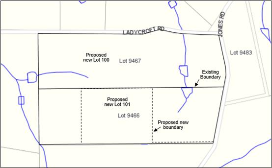
With a combined area of 81.4ha, both lots are owned by the same landowner and are accessed from Jones Road. As shown on the lots plan above, each property currently contains the origin of a creek line. Within Lots 9466 a creek commences in the eastern portion of the land, heading northward into 9467. The creek within 9467 commences just west of the centre of the property, adjacent to the southern boundary. This creek heads west into adjacent farmland.
Lot 9467 currently contains a Dwelling, 4 sheds ancillary to the agricultural use of the land and a dams. A Plantation located on the property was harvested in October 2014 and land returned to agricultural production. Lots 9466 contains a Dwelling, 2 sheds ancillary to the agricultural use of the land and a dam. Lot 9466 also contains approximately 20 ha of native vegetation. The property also carries development approval for an Industry – Extractive, granted by Council at its Ordinary meeting held on 18 January 2018.
The subdivision application proposes the realignment of the common boundary between the two lots. As shown on the attached plan of subdivision, proposed Lot 100 will have an area of 65.4ha and retain the dwelling, dams and buildings of Lots 9467. This lot will absorb 25.1ha of land from Lot 9466, as the landowner wishes to consolidate the arable sections of the land and one dam on Lots 9466 into one title, and allow for the expansion of agricultural activities currently undertaken.
Proposed Lot 101 will be 15.8ha in area, inclusive of a 12m wide, 374m long battleaxe access leg to provided vehicular access from Jones Road. This property will contain the dwelling and buildings of Lots 9466 as listed above, and be primarily vegetated. This property will also continue to be used for the Industry – Extractive granted by Council.
This subdivision proposes variations of Shire of Manjimup Local Planning Scheme No.4 (the Scheme) subdivision provisions over the land. Therefore, the purpose of this report is to seek Council’s discretion in light of the variations of Scheme provisions.
PUBLIC Consultation Undertaken:
The application has been advertised by WAPC to the local government as part of their advertising process. No public consultation has been undertaken.
COMMENT (Includes Options):
Scheme Compliance
Current Zoning under the Scheme
The subject property as stated above is zoned Priority Agriculture by the Scheme. Under this zone a minimum lot size of 80 ha will only be supported. A reduced lot size of 40ha or less may be supported, subject to the meeting the capability requirements clause 5.34.2 Subdivision and Development Standards of the Scheme and clause 5.34.4 Farm Restructuring.
The application is considered to generally comply with clause 5.34.2 of the Scheme, but proposes a variation to clause 5.34.4 as discussed below.
Farm Restructuring
In the case of farm restructuring or boundary adjustment in the Priority Agriculture zone, where no additional lots are created, the principal issue of consideration in assessment will be improving the sustainability and viability of the farming operation and observing the primary principle of protecting and enhancing the productive capacity of agricultural land. Where a farm consists of multiple titles and the proposal is to consolidate the main operation into a single title, consideration will be given to the creation of lots smaller than the outlined criteria or in other parts of the Scheme. Variations to this theme may be considered on their individual merits in line with these basic principles. These basic principles are:
(i) the smaller lots have sufficient size to allow for the construction of a dwelling and other small farm infrastructure and buildings with sufficient setback from adjoining properties so as not to restrict potential agricultural productivity on those properties;
(ii) the smaller lots are located so as to have minimal adverse impact on the viability and sustainability of the main farming property;
(iii) the total number of resulting lots is not greater than the original number of lots;
(iv) the local government being satisfied with the proposed method of access; and
(v) in the case of lifestyle lots, the land is located within 10km of a major townsite.
The subdivision as proposed is considered to meet (i) through to (iv) of the Farm Restructuring provisions. The application proposes a variation to provision (v), as the subject land is not located within 10 kilometres of a townsite. The closest major townsite is Manjimup, which is located 11 km from the proposal site.
In the opinion of Shire Officers, the variation to the distance from the Manjimup townsite is considered relatively minor, being 1 kilometre and the size of the proposed Lot 101 meeting the balance of Scheme provisions provided above. Despite the non-compliance, Shire Officers support variation of provision (v) given its minor nature.
Other Considerations
Bushfire Management
Regarding the further development of proposed Lot 101, Shire officers note that the property is mostly located within a Bushfire Prone Area as declared by the Minister of Emergency Services. Aside from the development that currently exists on proposed Lot 101, the Shire notes that any future development of this lot will need to be undertaken in accordance with State Planning Policy 3.7 Planning in Bushfire Prone Areas (SPP 3.7), and is subject to a development approval issued by the Shire prior to development commencing.
It is also noted that proposed Lot 100 contains sufficient land located outside the Bushfire Prone Area to be developed without the need to meet the requirements of SPP 3.7. Shire Officers are satisfied no consideration of bushfire threat to the property needs to be undertaken at this time.
Proximity of Proposed Lot 101 to Agricultural Operations
Given that Lot 101 is located within a rural locality with considerable agricultural activity taking place on nearby properties, Shire Officers recommend a condition to be included on the referral response to the WAPC that a notification, pursuant to Section 165 of the Planning and Development Act 2005 is to be placed on the certificate of title of the proposed Lot 101 advising of the existence of a hazard or other factor. Notice of this notification is to be also included on the diagram or plan of survey (deposited plan). The purpose of this is to notify any prospective purchaser of Lot 101 of the potential for the property to be affected by odour, spray drift, noise and dust generated by nearby agricultural activities.
Conclusion
On balance, Shire staff believe the Applicant has provided sufficient justification to allow Council to support the subdivision, subject to the conditions included in the Officer Recommendation.
STATUTORY ENVIRONMENT:
Planning & Development Act 2005 (as amended) and Shire of Manjimup Local Planning Scheme No 4.
Policy / Strategic Implications:
It is noted that the proposal seeks to subdivide land in a manner not consistent with the base Priority Agriculture zoning of the land. However, it does so on the grounds that the land is subject of a farm restructure as defined by the provisions of the Scheme. Therefore, there is no wide-scale precedent over the entire Priority Agriculture zone caused by supporting this application.
Organisational risk management:
Nil.
Financial Implications:
Nil.
Sustainability:
Environmental: The adoption of a proposed plan of subdivision plan does not, of itself, hold any environmental implications. It is noted that the proposed subdivision plan reflects the topography and capability of the land, in particular in relation to the existing remnant vegetation and watercourses over the land.
Economic: Approval of the application will ensure that a suitable water source is established and maintained to support expanding horticultural operations on the property. Approval to the application would therefore be consistent with Strategy B1 of the Shire’s Community Strategic Plan being to “Support sustainable agricultural expansion..”
Social: The nature of the proposed subdivision is not considered to cause any negative implication to the future development of the locality or generate a precedent for the subdivision of Priority Agriculture zoned land under the Scheme.
VOTING REQUIREMENTS: SIMPLE MAJORITY
Officer Recommendation:
That Council advise the Western Australian Planning Commission that it supports the subdivision of Lots 9466 & 9467 Jones Road, Yanmah in accordance with the Plan of Subdivision shown at Attachment 9.5.6(1) and subject to compliance with the following conditions:
a) A notification, pursuant to Section 165 of the Planning and Development Act 2005 is to be placed on the certificate of title of the proposed Lot 100 advising of the existence of a hazard or other factor. Notice of this notification is to be included on the diagram or plan of survey (deposited plan). The notification is to state as follows:
“This lot is located within an agricultural area and has the potential to be affected by odours, noise, spray drift and dust that are associated with the continued operation of adjoining agricultural land uses”.
b) The landowner/applicant shall provide a written undertaking to the satisfaction of the Western Australian Planning Commission to advise prospective purchasers of the provisions of the local government’s local planning scheme that relate to the use and management of the land.
c) Suitable arrangements being made with the local government for the provision of vehicular crossovers to service the lots shown on the approved plan of subdivision.
|
Moved: Salomone, J Seconded: Tapley, D
That Council advise the Western Australian Planning Commission that it supports the subdivision of Lots 9466 & 9467 Jones Road, Yanmah in accordance with the Plan of Subdivision shown at Attachment 9.5.6(1) and subject to compliance with the following conditions: a) A notification, pursuant to Section 165 of the Planning and Development Act 2005 is to be placed on the certificate of title of the proposed Lot 100 advising of the existence of a hazard or other factor. Notice of this notification is to be included on the diagram or plan of survey (deposited plan). The notification is to state as follows: “This lot is located within an agricultural area and has the potential to be affected by odours, noise, spray drift and dust that are associated with the continued operation of adjoining agricultural land uses”. b) The landowner/applicant shall provide a written undertaking to the satisfaction of the Western Australian Planning Commission to advise prospective purchasers of the provisions of the local government’s local planning scheme that relate to the use and management of the land. c) Suitable arrangements being made with the local government for the provision of vehicular crossovers to service the lots shown on the approved plan of subdivision. CARRIED: 8/0 |
71
Councillor Jenkins returned to the Chamber at 6.47pm.
ATTACHMENT
9.5.7 Proposed Industry - Extractive at Lot 7152 Perup Road, Perup
|
PROPONENT |
TL Dozing |
|
OWNER |
Kanangra Grazing Pty Ltd |
|
LOT / ADDRESS: |
Lot 7152 Perup Road, Perup |
|
WARD: |
East |
|
ZONE: |
General Agriculture |
|
DIRECTORATE: |
Development and Regulation |
|
FILE REFERENCE: |
DA17/247, P50642 |
|
LEGISLATION: |
Planning and Development Act 2005, Shire of Manjimup Local Planning Scheme No.4. |
|
AUTHOR: |
Jason Giadresco |
|
DATE OF REPORT: |
9/03/2018 |
|
DECLARATION OF INTEREST: |
Nil |
Background:
Council is requested to consider an application for planning approval for the establishment and operation of an Industry – Extractive (Gravel) at Lot 7152 Perup Road, Perup. A copy of the submitted application, including the submitted plans is attached.
ATTACHMENT: 9.5.7(1)
Lot Plan
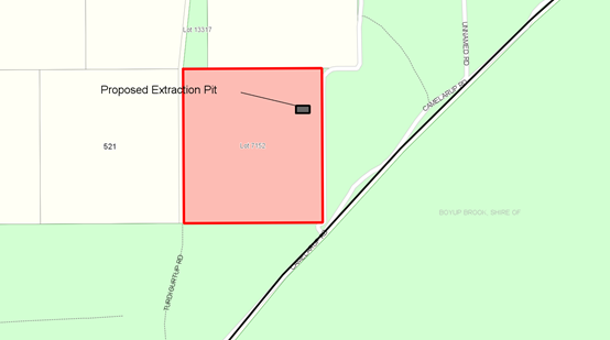
Lot 7152 Perup Road is 40.45ha in area. The property contains a vineyard and is completely cleared of native vegetation. The property contains no structures or dams. Despite the property’s given address, it is accessed from Camelarup Road. The property slopes from south-east to north-west.
The application proposes the extraction of gravel and laterite over a 70m by 150m area. In total 21,000m³ of material is proposed to be potentially removed.
As detailed in the submitted application, the applicant intends to use the pit to supply gravel commercially on a supply and demand basis to the Shire of Manjimup and Main Roads WA. The pit is proposed to be extracted to a depth of 2m, with topsoil stockpiled adjacent to the extraction site. All loading will be under taken by a ‘950’ loader into road trains and single trailer trucks. All truck haulage movements will enter the Shire’s road network on Camelarup Road, through to Junction Road to Kepal Road. From Kepal Road, Perup Road will be utilised to move the material to its final destination. On the return rout, vehicles will utilise Perup Road, Pomeroy Road, Junction Road and Camelarup Road to access the property.
It is detailed within the application that the pit would operate 5 days a week between 8:30am and 5:30pm, with up to 6 loads per day, or up to 30 loads per week to be extracted from the pit. However, the applicant has proposed an amendment to these aspects of the application as detailed further in the report.
Council is advised that the applicant has made a number of references within the application that the purpose of the gravel extraction on the property is to supply the Shire for its road maintenance program. Although the Shire at a future time may purchase gravel from the site should Council elect to approve the proposal, Shire Officers advise that the Shire has not entered into any agreement to secure gravel from this site, and the suggestion that the pit would be for Shire use has been made at the volition of the applicant.
This application requires determination by Council in accordance with Council policy given the submissions that were received during advertising of the proposal.
PUBLIC Consultation Undertaken:
The application was advertised in accordance with clause 9.6 of the Scheme, as a “Level D” application as required by Local Planning Policy 6.1.4 Advertising of Planning Proposals. Advertising consisted of a sign on site, correspondence to landowners within 1000m of the site, those on the proposed haulage routes, placed on the Shire of Manjimup website and an advertisement in the local newspaper.
A total of 16 submissions were received from nearby landowners and government agencies. Each of the submissions received have been summarised within the attached Schedule of Submissions whilst a full copy of the submissions can be made available to Councillors on request.
ATTACHMENT: 9.5.7(2)
COMMENT (Includes Options):
The provisions of Local Planning Scheme No 4 include the subject land within the “General Agriculture” Zone, where an Industry – Extractive is an “A” use. That is a use that is not permitted unless approved by Council following advertising of the proposal.
In accordance with clause 5.34.2.4 of the Scheme, development within the Priority Agriculture Zone is required to be setback 30 metres from the front and rear boundaries and 10 metres to side boundaries. The application as submitted substantially exceeds these setbacks, with a setback of 50m proposed to the closest boundary to the east of the proposed extractive site.
To guide Council in the determining this application, the following comments are offered:
Amended Information
Proposed Haulage Route
Several of the comments received noted ambiguity in the proposed haulage route as submitted by the applicant. The applicant has since clarified that they intend to use the route as described above.
Vehicle Movements
The applicant has stated that 28 loads per day will occur on this route on a temporary basis for the duration of Shire works. Once this work has been completed, the applicant anticipates 1 truck movement on this route per day would be the maximum. Again, Council is to note that the Shire has not purchased any material from the proposed pit, and therefore the truck movements proposed are advised to be discounted. The 30 truck movements per week as initially proposed by the applicant form the basis of the assessment of haulage movement.
The applicant has advised that the truck movements would occur during the hours of 6:30am to 4pm, and notes that a short section of Junction Road is under School Bus curfew and will operate in compliance with curfew conditions.
Dust Management
The applicant has advised dust levels along the proposed route will be monitored and suppressed as required. Water trucks will be used as required to reduce inconvenience to local residents.
A copy of the submitted email is attached.
ATTACHMENT: 9.5.7(3)
Access
The proposed access route was described as being from South Western Highway to Camelarup Road via Perup Road. Upon receiving a number of submissions highlighting ambiguity in respect of the proposed route, the applicant has proposed all truck haulage movements will enter Council’s road network on Camelarup Road, through to Junction Road to Kepal Road. From Kepal Road, Perup Road will be utilised to move the material to its final destination. On the return route, vehicles will utilise Perup Road, Pomeroy Road, Junction Road and Camelarup Road to return to the property.
All submissions raise concern with the possible use of the whole of Junction Road as the primary haulage route, with a number of properties located along its length. The main concerns raised are:
· The strong potential for dust to be generated by truck movements on Junction Road;
· The perceived degraded state of Junction and Perup Roads, and that an increase in haulage traffic will increase the state of road degradation;
· General safety for other road users, particularly visitors to the area, expressing the view that the road is too narrow to allow vehicles to safely pass each other;
· Potential conflict with the school bus route and the safety of children using this service.
The clarified transportation route avoids those landowners who have provided a submission regarding the above. The applicant has clearly stated it will not use Junction Road beyond the intersection with Department of Biodiversity, Conservation and Attractions (DBCA) – managed Kepal Road. This alternative route is designed to reduce road use conflict with landowners in the locality. Additionally, it is recommended that Council condition the development to ensure that truck movements do not occur during school bus route times.
With respect to road maintenance, the applicant will be required to maintain the current road standard at their expense. Regular site inspections may be undertaken by Shire staff to ensure this occurs for Camelarup, Junction and Perup Roads. DBCA have advised that the applicant will need to seek permission to utilise Kepal Road prior to commencement of the proposal should Council grant approval.
The above discussed will be reflected as conditions and advice in the event Council determines to approve the application.
Amenity
The majority of the submissions received raised concern that the proposal will detrimentally impact on the amenity of the area and properties abutting Junction Road through dust and noise associated with the use of the local road system. The potential for impact can be significantly reduced through restrictions on the operation times and the maximum number of truck movements. Given the proposed change in haulage route, it is expected that interruption of the local amenity would be minimal.
Notwithstanding the above, should Council wish to grant conditional approval to the proposal, it is recommended that conditions and advice be imposed to require the preparation and implementation of a Dust and Noise Management Plan to the satisfaction of the Chief Executive Officer.
Drainage Management
As reflected in the Schedule of Submissions, the Department of Water and Environment Regulation (DWER) cite that the ‘Drainage Management Plan’ (DMP) does not provide enough detail as to the depth of groundwater at the site, and have requested that a condition prohibiting excavation within the groundwater table be included on any approval issued.
Given the pit will be limited to a maximum depth of 2m below the natural ground levels and that it is located on a high area of the property, it is unlikely that the proposal will interfere with groundwater in the area. DWER also highlighted that the application does not provide enough detail as to the management of stormwater on site or the mitigation of potential chemical or fuel spills. DWER recommend the applicant develop a “Water Management Plan” for the site to mitigate any adverse impact on the local ground water as a condition of approval.
In light of the concerns raised, Shire officers recommend that an appropriate condition be imposed, reflecting the DWER’s advice.
Dieback Risk
One submission from a landowner and the advice provided by DBCA highlighted the risk posed by Dieback in the area. DBCA have noted that the materials to be extracted may contain dieback, and recommend that the materials not be used in dieback free areas. An advice note making the proponent aware of this will be included on approval granted by Council.
Site Rehabilitation
The applicant has indicated in their plans that the topsoil will be stockpiled and the site repastured once extraction has finished as the preferred method of rehabilitation. To ensure rehabilitation of the extraction site a condition restating the requirement to stockpile topsoil for the progressive rehabilitation of the site will be attached in the event approval is granted by Council.
Compliance with Local Planning Policy 6.1.9 Extractive Industries
The objective of the Policy is to protect the economic viability of the general farming areas and to retain the rural character of the area by preventing the operation of the Industry – Extractive in a detrimental manner. The proposed extraction is considered to comply with the requirements of the Policy, subject to standard conditions.
Time Limit on Approval
It is noted that the Applicant has sought a 5-year approval. Shire staff recommend any planning approval be limited to 5 years or the total proposed amount of material, whichever comes first. Limiting the approval will allow for the operation to be reconsidered in the light of its past performance in the event that an extension in time or volume of material is requested.
Conclusion
The application as submitted complies with the requirements of Local Planning Scheme No 4, adopted Council Policy and EPA Guidelines relating to land use buffers for extractive industries (providing neither screening or crushing is undertaken on site).
In order to reduce the potential impact on the adjacent landowners and amenity of the area, it is recommended that the operation should be restricted to times consistent with normal business hours Monday to Friday.
With appropriate conditions and management, it is the author of this reports opinion that the extractive industry can be undertaken with minimal impact on the amenity of the area.
STATUTORY ENVIRONMENT:
Planning and Development Act 2005 and Local Planning Scheme No. 4.
Policy / Strategic Implications:
The application has been assessed against the provisions of the Shire of Manjimup’s Local Planning Policy 6.1.9 Extractive Industries.
Organisational risk management:
Approval of this application by Council, provided that the Industry - Extractive is compliant with the Scheme and Policy, enforced through conditional consent granted by Council, will not generate any organisational risk.
Financial Implications:
The required Planning Application fee has been paid by the Proponent.
Sustainability:
Environmental: As detailed in the comment section above, appropriate conditions and standards of operation are required to ensure that the proposed activity will not result in environmental impact.
Economic: The development if approved will potentially increase the productive use of the land. Ensuring appropriate access to basic raw materials such as sand and gravel is identified by the state as critical to ensuring regional economic development.
Social: Without appropriate management and restrictions the proposal has potential to detrimentally impact on the amenity of the area and use of local roads.
VOTING REQUIREMENTS: SIMPLE MAJORITY
Officer Recommendation:
1. That Council having regard to the submissions received and in accordance with Part 10 of Shire of Manjimup Local Planning Scheme No.4 grants planning consent for the Industry - Extractive (Gravel) at Lot 7152 Perup Road, Perup (Application DA17/247) in accordance with the plans and specifications as submitted and subject to the following conditions:
a) The development hereby approved must be carried out generally in accordance with the plans and specifications submitted with the application and these shall not be altered and/or modified without the prior knowledge and written consent of the Shire of Manjimup;
b) Prior to commencement of the operation hereby approved, the applicant is to obtain the authorisation of the Department of Biodiversity Conservation and Attractions to use Kepal Road as part of the Industry – Extractive haulage route;
c) Prior to commencement of the activity hereby approved, the applicant shall prepare a detailed Water Management Plan to the satisfaction of the Chief Executive Officer and the Department of Water. This management plan shall as a minimum address the need to avoid interference with the water table and ensure issues of spill contamination and stormwater are addressed prior to extraction commencing;
d) All drainage and associated stormwater associated with the gravel extraction pit shall be contained on site to the satisfaction of the Chief Executive Officer;
e) No storage of petroleum products or chemicals shall occur on-site unless otherwise approved by the Shire of Manjimup;
f) This planning approval shall expire on 30 November 2023 or once the extraction volume of gravel extracted totals 21,000m³;
g) No more than 30 truck movements per week are permitted on the haulage route as proposed;
h) The operation of the Industry - Extractive and the transportation of materials from the site shall be restricted to the hours 8:30am to 5:30pm, Mondays to Fridays only, but shall not operate on Public Holidays or during the school bus curfew on Junction Road;
i) The activity hereby approved shall not include the screening or crushing of gravel on site, unless otherwise approved by The Shire of Manjimup;
j) Any damage to Camelarup, Junction, Pomeroy or Perup Roads caused by vehicles associated with the approved Industry - Extractive is to be repaired at the applicant’s cost to the satisfaction of the Shire of Manjimup;
k) Use of Junction Road by vehicles associated with the Industry – Extractive west of its intersection with Kepal Road is not permitted;
l) All topsoil located within the area to be subject of extraction is to be stockpiled and replaced as part of the rehabilitation process to the satisfaction of the Shire of Manjimup;
m) The development must not cause airborne dust nuisance to neighbours, or properties located on the nominated haulage route. In this regard, and prior to the commencement of any such works, the developer is required to prepare and submit to local government for approval a Dust and Noise Management Plan covering the measures to be undertaken throughout the duration of the works. The plan as may be approved by the Shire of Manjimup and shall be implemented to its satisfaction.
2. Advice to Applicant:
a) That the gravel is likely to contain dieback. It is recommended that the materials not be used in dieback free areas.
b) With regard to Condition b) above, the applicant is requested to contact the Department of Biodiversity Conservation and Attractions Warren Office on (08) 9771 7988. Additionally, a copy of the written authorisation from the Department of Biodiversity Conservation and Attractions to use Kepal Road is to be forwarded to the Shire of Manjimup for its records
c) That the proposed operation is required to comply with the ‘Environmental Protection (Noise) Regulations, 1997’.
3. Those persons who lodged submissions be advised of Council decision and the officer recommendation as attached at 9.5.7(2).
|
Moved: Ventris, M Seconded: Jenkins, D
1. That Council having regard to the submissions received and in accordance with Part 10 of Shire of Manjimup Local Planning Scheme No.4 grants planning consent for the Industry - Extractive (Gravel) at Lot 7152 Perup Road, Perup (Application DA17/247) in accordance with the plans and specifications as submitted and subject to the following conditions: a) The development hereby approved must be carried out generally in accordance with the plans and specifications submitted with the application and these shall not be altered and/or modified without the prior knowledge and written consent of the Shire of Manjimup; b) Prior to commencement of the operation hereby approved, the applicant is to obtain the authorisation of the Department of Biodiversity Conservation and Attractions to use Kepal Road as part of the Industry – Extractive haulage route; c) Prior to commencement of the activity hereby approved, the applicant shall prepare a detailed Water Management Plan to the satisfaction of the Chief Executive Officer and the Department of Water. This management plan shall as a minimum address the need to avoid interference with the water table and ensure issues of spill contamination and stormwater are addressed prior to extraction commencing; d) All drainage and associated stormwater associated with the gravel extraction pit shall be contained on site to the satisfaction of the Chief Executive Officer; e) No storage of petroleum products or chemicals shall occur on-site unless otherwise approved by the Shire of Manjimup; f) This planning approval shall expire on 30 November 2023 or once the extraction volume of gravel extracted totals 21,000m³; g) No more than 30 truck movements per week are permitted on the haulage route as proposed; h) The operation of the Industry - Extractive and the transportation of materials from the site shall be restricted to the hours 8:30am to 5:30pm, Mondays to Fridays only, but shall not operate on Public Holidays or during the school bus curfew on Junction Road; i) The activity hereby approved shall not include the screening or crushing of gravel on site, unless otherwise approved by The Shire of Manjimup; j) Any damage to Camelarup, Junction, Pomeroy or Perup Roads caused by vehicles associated with the approved Industry - Extractive is to be repaired at the applicant’s cost to the satisfaction of the Shire of Manjimup; k) Use of Junction Road by vehicles associated with the Industry – Extractive west of its intersection with Kepal Road is not permitted; l) All topsoil located within the area to be subject of extraction is to be stockpiled and replaced as part of the rehabilitation process to the satisfaction of the Shire of Manjimup; m) The development must not cause airborne dust nuisance to neighbours, or properties located on the nominated haulage route. In this regard, and prior to the commencement of any such works, the developer is required to prepare and submit to local government for approval a Dust and Noise Management Plan covering the measures to be undertaken throughout the duration of the works. The plan as may be approved by the Shire of Manjimup and shall be implemented to its satisfaction. 2. Advice to Applicant: a) That the gravel is likely to contain dieback. It is recommended that the materials not be used in dieback free areas. b) With regard to Condition b) above, the applicant is requested to contact the Department of Biodiversity Conservation and Attractions Warren Office on (08) 9771 7988. Additionally, a copy of the written authorisation from the Department of Biodiversity Conservation and Attractions to use Kepal Road is to be forwarded to the Shire of Manjimup for its records c) That the proposed operation is required to comply with the ‘Environmental Protection (Noise) Regulations, 1997’. 3. Those persons who lodged submissions be advised of Council decision and the officer recommendation as attached at 9.5.7(2).
CARRIED: 9/0 |
80
9.5.8 Proposed Industry - Extractive at Lot 739 (274) Dingup Road, Dingup
|
PROPONENT |
Dronow Contracting |
|
OWNER |
I A N Wauchope |
|
LOCATION / ADDRESS: |
Lot 739 (274) Dingup Road, Dingup |
|
WARD: |
East |
|
ZONE: |
Priority Agriculture |
|
DIRECTORATE: |
Development and Regulation |
|
FILE REFERENCE: |
P56704, DA 17/243 |
|
LEGISLATION: |
Planning and Development Act 2005; Shire of Manjimup Local Planning Scheme No.4 |
|
AUTHOR: |
Jason Giadresco; Brian Robinson |
|
DATE OF REPORT: |
9 March 2018 |
|
DECLARATION OF INTEREST: |
Nil |
Background:
Council is requested to consider an application for planning approval for the establishment and operation of an Industry – Extractive (Gravel/Laterite) at Lot 739 (274) Dingup Road, Dingup. A copy of the submitted application, including the submitted plans is attached.
ATTACHMENT: 9.5.8(1)
Location Plan
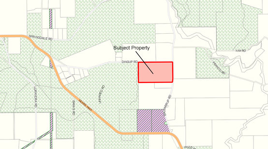
Lot 739 Dingup Road is 41ha in area. The property contains 2 dams with a combined surface area of 1.2ha, a dwelling and 2 sheds. The property is predominately used for orchard operations. The property is elevated, with the land declining from the highest point in the south-west corner to the north-east with a fall of approximately 70m. A 3.5ha stand of remnant native vegetation is located in the south-eastern corner of the property.
The application proposes the extraction of gravel and laterite over a 3ha area, with only 1ha open to extraction at any one time. Given the applicant has indicated an area of 3ha at a depth of 2m, a total 60,000m³ of material will potentially be removed from the site.
As detailed in the submitted application, the applicant intends to use the pit to supply gravel commercially on a supply and demand basis. The pit area will be ripped and cleared using a bulldozer. The pit is proposed to be extracted to a depth of 2m, with topsoil stockpiled adjacent to the extraction site. All loading will be under taken by a 120kw loader into side-tipper trucks, end-over semi-trailers or 6 by 4 rigid trucks. All truck haulage movements will enter the Shire’s road network on Balbarrup Road, via a constructed internal driveway partially adjacent to the southern side of the property. From Balbarrup Road, either Perup Road or Muirs Highway will be utilised to move the material to its final destination.
It is proposed that the pit would operate 7 days a week between 6:00am and 5:30pm Monday to Friday and from 7:00am to 12:00pm Saturday and Sunday, with up to 50 loads per day, or up to 250 loads per week to be extracted from the pit as provided in the application.
Elected members may be aware that a previous application for approval for an Industry – Extractive on this property was brought before Council at its Ordinary Meeting of 10 November 2016. The application was refused by Council at the time, and the applicant elected to have the proposal considered by the State Administrative Tribunal. The applicant subsequently withdrew the application from the Tribunal hearings.
The application that is now before Council includes a number of amendments to the original proposal, which are summarised as follows:
a) Modification of the proposed access arrangements;
b) Inclusion of additional proposed management arrangements in respect of dust and noise management; and
c) The inclusion of crushing and screening processes on-site.
The application requires determination by Council in accordance with Council policy given the submissions that were received during advertising of the proposal.
PUBLIC Consultation Undertaken:
The application was advertised in accordance with clause 9.6 of the Scheme, as a “Level D” application as required by Local Planning Policy 6.1.2 Advertising of Planning Proposals. Advertising consisted of a sign on site, correspondence to landowners within 1000m of the site, entry on the Shire website and an advertisement in the local newspaper.
A total of 37 submissions were received. Three (3) submissions were received from government agencies. Each of the submissions received have been summarised within the attached Schedule of Submissions, whilst a full copy of the submissions can be made available to Councillors on request.
ATTACHMENT: 9.5.8(2)
COMMENT (Includes Options):
The provisions of Local Planning Scheme No 4 (LPS No 4) include the subject land within the “Priority Agriculture” Zone, where an Industry – Extractive is an “A” use. That is a use that is not permitted unless approved by Council following advertising of the proposal.
LPS No 4 - clause 10.2 outlines those matters that must be considered when assessing an application for Planning Approval. Those matters relevant to the current application are, in the opinion of the author, as follows:-
(i) the aims and provisions of the Scheme and any other relevant Local Planning Scheme operating within the Scheme area;
(iv) any approved Environmental Protection Policy under the Environmental Protection Act 1986;
(v) any relevant policy or strategy of the Commission and any relevant policy adopted by the Government of the State;
(x) the compatibility of a use or development with its setting including the potential impact on the use and enjoyment of adjacent and nearby land and taking into consideration any Special Control Area;
(xv) the preservation of the amenity of the locality;
(xvi) the relationship of the proposal to development on adjoining land or on other land in the locality including but not limited to, the likely effect of the height, bulk, scale, orientation and appearance of the proposal; and
(xviii) the amount of traffic likely to be generated by the proposal, particularly in relation to the capacity of the road system in the locality and the probable effect on traffic flow and safety;
To assist Council in determining the application, the following comments are offered in respect of the matters to be considered:
Setbacks
In accordance with clause 5.34.2.4 of LPS No 4, development within the Priority Agriculture Zone is required to be setback 30 metres from the front and rear boundaries and 10 metres to side boundaries. The application as submitted substantially exceeds these setbacks, with a setback of 260m proposed to Dingup Road.
Environmental Protection Authority Guidelines
In addition to setbacks prescribed by LPS No 4, Council must have regard to the provisions of the Environmental Protection Authority (EPA) Guidelines entitled “Guidance for the Assessment of Environmental Factors – Separation Distances between Industrial and Sensitive Land Uses”. These guidelines provide advice on the "use of generic separation distances (buffers) between industrial and sensitive land uses to avoid land use conflicts between incompatible land uses.”
The buffer distances are necessary to avoid or minimise the potential for land use conflict. As stated within section 2 of the guidelines “whilst not replacing the need for best practice approaches to emission management, the use of buffers is a useful tool in achieving an acceptable environmental outcome”. The guidelines furthermore outline that a proponent or responsible authority wishing to deviate from the guidelines, is expected to put a well-researched, robust and clear justification for that deviation.
The guidelines acknowledge that a sound site-specific technical analysis is generally found to provide the most appropriate guide to separation distances between industry and sensitive land uses. However “in recognition that a site specific study may not be necessary in all situations, generic distances have been developed” based on the experience of the Department of Environment and other regulatory authorities (e.g. EPA Victoria). Within the guidelines, it is also stated that “The separation distances outlined are not intended to replace the need for proponent and relevant authorities to take all reasonable and practicable measures to minimise emissions and off-site impacts.”
As prescribed within Appendix No 1 of that document, a minimum buffer of 1000m is recommended for extractive industries that involving crushing and/or screening on-site. With respect to the submitted application, the proposed area to be excavated is setback 260m from the common boundary with Dingup Road. A buffer of approximately 400 metres is therefore proposed between the extractive industry and the nearest dwelling. In the absence of a robust scientific study demonstrating the acceptability of a lesser separation distance, a relaxation of the EPA Guidelines is not recommended.
This issue has been discussed with the proponent. As a result of those discussions the applicant has verbally indicated that they will not be proceeding with crushing or screening on-site.
The EPA guidelines recommend a minimum buffer of 300-500m for Extractive Industries that do not involve crushing/screening. As detailed above, approval to the application would result in the extraction pit being located approximately 400m from the nearest residence, consistent with the EPA guidelines.
To ensure no crushing/screening occurs on site, an appropriate condition of approval is recommended. The applicant is aware of the Shire Officers intention to make this recommendation.
To guide Council in the determining this application, the following comments are offered:
Amenity
The majority of the submissions received raise concern that the proposal will detrimentally impact on the amenity of the area and properties abutting Dingup and Balbarrup Roads through dust and noise associated with both the activity on site and the use of the local road system. The hours of operation proposed where also of considerable concern to landowners. The potential for impact can be significantly reduced through restrictions on the operation times and the maximum number of truck movements.
In order to minimise the potential impact on the amenity of the area, it is recommended that consideration be given to limiting the hours of operation to 8:30am to 3pm Monday to Friday only. It is also recommended that consideration be given to limit the maximum number of truck movements per day.
Comments in respect of dust impacting on water resources cannot supported on the basis that the Australian Drinking Water Guidelines identify that dust is not health factor of consideration with regard to rainwater harvesting.
Notwithstanding the above, should Council wish to grant conditional approval to the proposal, it is recommended that conditions be imposed to require the preparation and implementation of a Dust Management Plan and Noise Management Plan to the satisfaction of the Chief Executive Officer.
Concerns regarding the amenity impact of the extractive industry were also raised in the submissions received, with particular reference to land located immediately north of Dingup Road containing Dingup House, being a local tourist facility and accommodation provider.
Whilst the comments received highlighting the elevation of the land are acknowledged, the extractive industry will be undertaken over a total of 3ha in the center of the 40ha property. In accordance with Council policy, the activity required to occupy a maximum of 1ha at any one time (being equivalent to 2.5% of the property). In the opinion of the author, the impact on the visual amenity for properties located on the northern side of Dingup Road will be minimal.
Access
Details submitted with the application indicate that if approved, all access to the Extractive Industry will be provided via Balbarrup Road. Depending on the end destination, Balbarrup Road will then be used to access either Perup Road or Muirs Highway.
Submissions received from landowners in the area raise concerns regarding the standard of Balbarrup Road and the potential impact 50 truck movements will have on its maintenance. The majority of submissions also raise concerns over safety standards in respect of:
i) the proposed driveway access location and its proximity to a crest in Balbarrup Road;
ii) potential conflict with the school bus route and the safety of children using this service;
iii) the potential for conflict with horse riders and other recreational users of the road;
iv) general safety for other road users, particularly visitors to the area, expressing the view that the road is too narrow to allow vehicles to safely pass each other.
In response, the Shire Officers advise that the proposed driveway access is acceptable given that there are clear sightlines for over 100m in each direction. In terms of general road safety Council is further advised that:
a) Balbarrup Road is a local rural road that varies in width between 6 to 8 metres, providing sufficient room for two vehicles to pass;
b) As a gravel road, the road is not subject to speed zones;
c) The Shire is able to condition the development to ensure that truck movements do not occur during school bus route times; and
d) Speed restrictions could be imposed for the entire length of Balbarrup Road through conditions of approval.
In light of the submissions received from landowners along the route regarding the potential for dust and noise generated by the proposal, Shire Officers recommend a Traffic Management Plan be prepared to the satisfaction of the Chief Executive Officer, ensuring the safe use of Balbarrup Road is maintained while the proposal is in operation. It is recommended by Shire officers that conditions to this effect be included in the event Council approves the application.
With respect to road maintenance, the applicant will be required to maintain the current road standard at their expense. Regular site inspections may be undertaken by Shire staff to ensure this occurs for Perup and Balbarrup Roads.
Potential for Alternative Access
A suggestion has made within several of the submissions received that State Forest Roads located to the rear of the property could be used to access Muirs Highway, removing the need to utilise Balbarrup Road.
Whilst the intent behind these suggestions is noted, Council is obliged to consider the current application on its merits and determine whether the access as proposed is acceptable. Advice from the Manager of Technical Services indicates that the use of Balbarrup Road is acceptable from a traffic management view point.
Heritage Considerations
The submissions received raised specific concerns relating to the impact on the visual amenity of Dingup House and the potential for the activity to impact on the structural integrity of the heritage listed building due to vibrations associated with the activity.
The Dingup Homestead Group was classified by the National Trust in 1987 and subsequently was listed on the Register of the National Estate since 1988. The property has been included on the State Heritage Register as a place of Heritage Significance since 1989 and the Shires Municipal Heritage Inventory since 1997 within management Category A.
In accordance with clause 10.2 (ix) of Local Planning Scheme No 4, Council is required to have regard to “the conservation of any place that has been entered in the Register within the meaning of the Heritage of Western Australia Act 1990, or which is included in the Heritage List under Clause 7.1, and the effect of the proposal on the character or appearance of a heritage area”.
In this case as the proposal is not located on the land identified as having Heritage Significance, the application will not impact the character or appearance of the Heritage Place. Rather it will have potential to impact on the views from the property. The protection of existing views is not a valid planning consideration.
With respect to the comments received expressing concern over the potential impact on the structural integrity of Dingup House, Council may wish to impose a requirement for a dilapidation report to be prepared prior to commencement of the activity. However given the elevation of the site and separation distance Shire officers consider it unlikely that the activity will have any impact on the structural integrity.
Drainage Management
As reflected in the Schedule of Submissions, the Department of Water (DWER), and a number of those persons who lodged submissions raise concern with the potential impacts of the proposal on the integrity of local groundwater and stormwater movement. DWER cite that the Drainage Management Plan (DMP) does not provide enough detail as to the depth of groundwater at the site, and have requested that a condition prohibiting excavation within the groundwater table be included on any approval issued.
The applicant has provided details within the application that groundwater was not found at a depth of 3.5m below the natural surface of the site during testing. Given the pit will be limited to a maximum depth of 2m below the natural ground levels, it is unlikely that the proposal will interfere with groundwater in the area. However in light of the concerns raised, Shire officers recommend that Council include DWER’s advice as a condition in order to ensure compliance.
The proposal’s DMP provides that all storm water run-off is to enter a water relief point adjacent to the pit in order to address potential turbidity issues. Drainage could then be directed across the natural land form into the dam adjacent to Dingup Road. DWER and a number of the submissions state that stormwater management needs to be better managed on-site to prevent stormwater flows affecting adjoining landowners.
Shire officers also note that the current proposed management of stormwater could impact on the usability of Dingup Road. To this end, Shire officers recommend that Council condition the applicant to provide further detail as to how stormwater will be contained on-site, turbidity from the stormwater removed and pre-development water flows from Lot 739 are maintained to ensure that no greater stormwater impacts do not affect the use of Dingup Road or adjoining properties.
DWER have additionally provided a number of standard conditions pertaining to:
· no dewatering of the extraction area;
· no standing water to be left on site post-rehabilitation;
· no storage of hydrocarbons on site;
· that any on-site refuelling is to be from a mobile service vehicle carrying appropriate spill prevention and clean-up equipment; and
· no major repairs or maintenance of vehicles used in the proposal are to be undertaken on site.
The above listed conditions provided by DWER will be included on any approval issued by Council to ensure these requirements are met.
Site Rehabilitation
The proponent has indicated 1ha of the site will be exposed for extraction at any one time, in accordance with the Policy. The applicant has indicated in their plans that the topsoil will be stockpiled and the site re-pastured once extraction has finished as the preferred method of rehabilitation. To ensure rehabilitation of the extraction site a condition restating the requirement to stockpile topsoil for the progressive rehabilitation of the site will be attached in the event approval is granted by Council. DBCA has requested that an Environmental Management Plan be prepared to address the proposal. Shire Officers recommend inclusion of this condition should Council issue approval for the development.
Compliance with Local Planning Policy 6.1.9 Extractive Industries
The objective of the Policy is to protect the economic viability of the general farming areas and to retain the rural character of the area by preventing the operation of the Industry – Extractive in a detrimental manner. The proposed extraction is considered to comply with the requirements of the Policy, subject to standard conditions.
Time Limit on Approval
It is noted that the Applicant has sought a 5-year approval. Shire staff recommend any planning approval be limited to 5 years or the total proposed amount of material, whichever comes first. Limiting the approval will allow for the operation to be reconsidered in the light of its past performance in the event that an extension in time or volume of material is requested.
Aboriginal Heritage
One submission from an adjoining landowner has suggested that the subject property may have Aboriginal heritage value. A desktop survey of the site using the Department of Aboriginal Affairs heritage mapping tools indicates no identified sites on Lot 739, but is subject to an ongoing heritage survey. As such, Shire Officers cannot confirm or deny the significance of the site. The Scheme provides that in addition to development approval being issued by Council, an applicant may require the consent of the Minister for Indigenous Affairs under the Aboriginal Heritage Act 1972 before commencing development for which planning approval has been granted.
Shire officer recommend that a condition requiring the applicant to contact the Department of Aboriginal Affairs to determine whether further approval is needed to commence the works will be included as a condition in the event Council determines to grant approval.
Conclusion
The application as submitted complies with the requirements of Local Planning Scheme No 4, adopted Council Policy and EPA Guidelines relating to land use buffers for extractive industries (providing neither screening or crushing is undertaken on site).
In order to reduce the potential impact on the adjacent landowners and amenity of the area, it is recommended that the operation should be restricted to times consistent with normal business hours Monday to Friday.
Furthermore to limit the impact on local roads and avoid potential conflict with the school bus route, it is recommended that appropriate conditions be placed on the approval to:
(i) limit the maximum number of truck movements to 20 per day (i.e. 10 loads); and
(ii) Restrict the hours of operation on site, including associated truck movements) to between 8:30am and 3:00pm.
With appropriate conditions and management, it is the author of this reports opinion that the extractive industry can be undertaken with minimal impact on the amenity of the area.
STATUTORY ENVIRONMENT:
Planning and Development Act 2005 and Local Planning Scheme No. 4.
Applications for Planning Approval within the Shire are determined in accordance with Part 10 of the Scheme. As outlined by clause 10.2, options available to Council are to:
(a) Approve the application, with or without conditions; or
(b) Refuse the application.
In this case, Shire officers recommend that the application be approved subject to appropriate conditions to address those concerns raised within the submissions received.
In accordance with clause 10.8, the conditions of approval may require the submission and approval of later details. In this case it is recommended that Dust Management, Traffic Management, Noise Management and Water Management Plans be required.
Policy / Strategic Implications:
The application has been assessed against the provisions of the Shire of Manjimup’s Local Planning Policy 6.1.9 Extractive Industries.
Organisational risk management:
Approval of this application by Council, provided that the Industry - Extractive is compliant with the Scheme and Policy, enforced through conditional consent granted by Council, will not generate any organisational risk.
Financial Implications:
The required Planning Application fee has been paid by the Proponent.
Sustainability:
Environmental: As detailed in the comment section above, appropriate conditions and standards of operation are required to ensure that the proposed activity will not result in environmental impact.
Economic: The development if approved will potentially increase the productive use of the land. Ensuring appropriate access to basic raw materials such as sand and gravel is identified by the state as critical to ensuring regional economic development.
Social: Without appropriate management and restrictions the proposal has potential to detrimentally impact on the amenity of the area and use of Balbarrup Road.
VOTING REQUIREMENTS: SIMPLE MAJORITY
Officer Recommendation:
1. That Council having regard to the submissions received and in accordance with Part 10 of Shire of Manjimup Local Planning Scheme No.4 grants planning consent for the Industry Extractive (Gravel/Laterite) at Lot 739 (274) Dingup Road, Dingup (Application DA 17/243) in accordance with the plans and specifications as submitted and subject to the following conditions:
a) Except where specified within the following conditions, the development hereby approved must be carried out generally in accordance with the plans and specifications submitted with the application and these shall not be altered and/or modified without the prior knowledge and written consent of the Shire of Manjimup;
b) The activity hereby approved shall not include the screening or crushing of gravel on site, unless otherwise approved by the Shire of Manjimup;
c) Prior to commencement of the activity hereby approved, the applicant shall prepare a detailed Drainage Management Plan to the satisfaction of the Chief Executive Officer and the Department of Water. This management plan shall as a minimum address the need to avoid interference with the water table and ensure issues of turbidity are addressed prior to water entering dams on the property;
d) Prior to the commencement of the Industry – Extractive, the applicant is to prepare and submit a Traffic Management Plan for the proposed haulage route, to the satisfaction of the Shire of Manjimup;
e) Prior to commencement of the Industry – Extractive as approved, the applicant is to obtain the further approval of the Department of Aboriginal Affairs to operate;
f) All drainage and associated stormwater associated with the gravel extraction pit shall be contained on site to the satisfaction of the Chief Executive Officer;
g) This planning approval shall expire on 31 March 2023 or once the extraction area has reached a total of 3ha and/or the volume of gravel extracted totals 60,000m³;
h) The operation of the Industry - Extractive and the transportation of materials from the site shall be restricted to the hours 8:30am to 3:00pm, Mondays to Fridays only, but shall not operate on Public Holidays;
i) Prior to commencement of the activity, a noise management plan inclusive of an acoustic assessment shall be prepared to the satisfaction of Chief Executive Officer;
j) The applicant shall install and maintain traffic control along all roads used by the development, warning other road users of trucks entering and using the public road system to the specification and satisfaction of the Shire of Manjimup;
k) Truck movements associated with the land use hereby approved shall not exceed 20 movements per day (i.e. 10 loads of gravel);
l) Any damage to Perup or Balbarrup Roads caused by vehicles associated with the approved Industry - Extractive is to be repaired at the applicant’s cost to the satisfaction of the Shire of Manjimup;
m) All topsoil located within the area to be subject of extraction is to be stockpiled and replaced as part of the rehabilitation process to the satisfaction of the Shire of Manjimup;
n) The development must not create a nuisance to neighbours through airborne dust nuisance or noise. In this regard, and prior to the commencement of any such works, the developer is required to prepare and submit to local government for approval a Noise and Dust Management Plan covering the measures to be undertaken throughout the duration of the works, both on site, and along Balbarrup Road. The plan as may be approved by local government shall be implemented to its satisfaction.
o) No more than 1 hectare is to be open to extraction at any one time, with progressive rehabilitation of the site to be undertaken for those areas where extraction has been completed to the satisfaction of the Shire of Manjimup;
p) Prior to the commencement of the Industry – Extractive, the applicant is to prepare and submit an Environmental Management Plan for the development, to the satisfaction of the Shire of Manjimup;
q) No hydrocarbons are to be stored on-site;
r) On-site refuelling of equipment may only be from a mobile service vehicle carrying appropriate spill prevention and clean-up equipment;
s) No major repairs or maintenance will take place on site; and
t) No standing water shall occur at the site post-rehabilitation.
Advice to Applicant:
i) Further to condition No b) above, the applicant is advised that in accordance with EPA guidelines for Extractive Industries, a minimum buffer of 1000m is recommended between an extractive industry involving crushing and the nearest residence. In this case, as the extraction pits will be located less than 500m, the Shire is not prepared to support the crushing or screening of gravel in the absence of a scientific assessment, prepared by a suitably qualified consultant demonstrating that a lesser separation will not impact on the adjacent residential dwellings.
ii) The restrictions on the hours of operation and maximum truck movements have been imposed to limit the impact of the activity and associated truck movements on properties abutting Balbarrup Road.
iii) That the proposed operation is required to comply with the ‘Environmental Protection (Noise) Regulations, 1997’;
2. Those persons who lodged submissions be advised of Council decision and the officer recommendation as detailed in Attachment 9.5.8(2).
|
Moved: Jenkins, D Seconded: Ventris, M
1. That Council having regard to the submissions received and in accordance with Part 10 of Shire of Manjimup Local Planning Scheme No.4 grants planning consent for the Industry Extractive (Gravel/Laterite) at Lot 739 (274) Dingup Road, Dingup (Application DA 17/243) in accordance with the plans and specifications as submitted and subject to the following conditions: a) Except where specified within the following conditions, the development hereby approved must be carried out generally in accordance with the plans and specifications submitted with the application and these shall not be altered and/or modified without the prior knowledge and written consent of the Shire of Manjimup; b) The activity hereby approved shall not include the screening or crushing of gravel on site, unless otherwise approved by the Shire of Manjimup; c) Prior to commencement of the activity hereby approved, the applicant shall prepare a detailed Drainage Management Plan to the satisfaction of the Chief Executive Officer and the Department of Water. This management plan shall as a minimum address the need to avoid interference with the water table and ensure issues of turbidity are addressed prior to water entering dams on the property; d) Prior to the commencement of the Industry – Extractive, the applicant is to prepare and submit a Traffic Management Plan for the proposed haulage route, to the satisfaction of the Shire of Manjimup; e) Prior to commencement of the Industry – Extractive as approved, the applicant is to obtain the further approval of the Department of Aboriginal Affairs to operate; f) All drainage and associated stormwater associated with the gravel extraction pit shall be contained on site to the satisfaction of the Chief Executive Officer; g) This planning approval shall expire on 31 March 2023 or once the extraction area has reached a total of 3ha and/or the volume of gravel extracted totals 60,000m³; h) The operation of the Industry - Extractive and the transportation of materials from the site shall be restricted to the hours 8:30am to 3:00pm, Mondays to Fridays only, but shall not operate on Public Holidays; i) Prior to commencement of the activity, a noise management plan inclusive of an acoustic assessment shall be prepared to the satisfaction of Chief Executive Officer; j) The applicant shall install and maintain traffic control along all roads used by the development, warning other road users of trucks entering and using the public road system to the specification and satisfaction of the Shire of Manjimup; k) Truck movements associated with the land use hereby approved shall not exceed 20 movements per day (i.e. 10 loads of gravel); l) Any damage to Perup or Balbarrup Roads caused by vehicles associated with the approved Industry - Extractive is to be repaired at the applicant’s cost to the satisfaction of the Shire of Manjimup; m) All topsoil located within the area to be subject of extraction is to be stockpiled and replaced as part of the rehabilitation process to the satisfaction of the Shire of Manjimup; n) The development must not create a nuisance to neighbours through airborne dust nuisance or noise. In this regard, and prior to the commencement of any such works, the developer is required to prepare and submit to local government for approval a Noise and Dust Management Plan covering the measures to be undertaken throughout the duration of the works, both on site, and along Balbarrup Road. The plan as may be approved by local government shall be implemented to its satisfaction. o) No more than 1 hectare is to be open to extraction at any one time, with progressive rehabilitation of the site to be undertaken for those areas where extraction has been completed to the satisfaction of the Shire of Manjimup; p) Prior to the commencement of the Industry – Extractive, the applicant is to prepare and submit an Environmental Management Plan for the development, to the satisfaction of the Shire of Manjimup; q) No hydrocarbons are to be stored on-site; r) On-site refuelling of equipment may only be from a mobile service vehicle carrying appropriate spill prevention and clean-up equipment; s) No major repairs or maintenance will take place on site; and t) No standing water shall occur at the site post-rehabilitation. Advice to Applicant: i) Further to condition No b) above, the applicant is advised that in accordance with EPA guidelines for Extractive Industries, a minimum buffer of 1000m is recommended between an extractive industry involving crushing and the nearest residence. In this case, as the extraction pits will be located less than 500m, the Shire is not prepared to support the crushing or screening of gravel in the absence of a scientific assessment, prepared by a suitably qualified consultant demonstrating that a lesser separation will not impact on the adjacent residential dwellings. ii) The restrictions on the hours of operation and maximum truck movements have been imposed to limit the impact of the activity and associated truck movements on properties abutting Balbarrup Road. iii) That the proposed operation is required to comply with the ‘Environmental Protection (Noise) Regulations, 1997’;
2. Those persons who lodged submissions be advised of Council decision and the officer recommendation as detailed in Attachment 9.5.8(2). MOTION carried 6/3
|
94
APPENDIX
9.13.1 Review of Works and Services Policy 10.1.9 School Aid by Council's Works and Services Directorate
|
PROPONENT |
Shire of Manjimup |
|
OWNER |
Shire of Manjimup |
|
LOCATION / ADDRESS: |
Whole of Shire |
|
WARD: |
All |
|
ZONE: |
N/A |
|
DIRECTORATE: |
Works and Services |
|
FILE REFERENCE: |
F161013 |
|
LEGISLATION: |
Local Government Act 1995 |
|
AUTHOR: |
Andrew Johns |
|
DATE OF REPORT: |
8/03/2018 |
|
DECLARATION OF INTEREST: |
Nil |
Background:
Council policy 10.1.9 School Aid by Council’s Works Directorate was reviewed in March 2014, scheduled for review in March 2018 and is appended.
APPENDIX: 9.13.1(A)
PUBLIC Consultation Undertaken:
Nil
COMMENT (Includes Options):
Shire Officers have thoroughly reviewed the policy and identified a small number of recommended changes. The proposed changes to the policy are:
· Updating the title to correctly reflect the directorate’s name;
· Updating the title of the responsible officer; and
· Clarification regarding the time for use of road plant as one (1) hour “on site”.
The amended policy can be found in the attachment.
ATTACHMENT: 9.13.1(1)
STATUTORY ENVIRONMENT:
Local Government Act 1995.
Policy / Strategic Implications:
Regular reviews are undertaken of Local Government operations and policies. These reviews are necessary to ensure continued compliance, provide strategic direction and improve operations.
Organisational risk management:
The policy provides clear definition of resources the Shire can provide to each school in the district at no charge per year.
Financial Implications:
Minimal costs will be incurred per application of the policy, allocated to works department maintenance expenditure.
Sustainability:
Environmental: Nil.
Economic: Nil
Social: The reputation of the Shire within the community should be enhanced through the application of this policy.
VOTING REQUIREMENTS: SIMPLE MAJORITY
Officer Recommendation:
That Council adopts the reviewed Council policy 10.1.9 School Aid by Council’s Works and Services Directorate, as attached: 9.13.1(1).
|
Moved: Taylor, R Seconded: Eiby, W
That Council adopts the reviewed Council policy 10.1.9 School Aid by Council’s Works and Services Directorate, as attached: 9.13.1(1). CARRIED: 9/0 |
96
9.15.1 Minutes of the Manjimup Agricultural Expansion Project Management Committee Meeting 20 February 2018
|
PROPONENT |
Shire of Manjimup |
|
OWNER |
N/A |
|
LOCATION / ADDRESS: |
Whole of Shire |
|
WARD: |
All |
|
ZONE: |
All |
|
DIRECTORATE: |
Office of the CEO |
|
FILE REFERENCE: |
F160285 |
|
LEGISLATION: |
Local Government Act 1995 |
|
AUTHOR: |
Andrew Campbell |
|
DATE OF REPORT: |
28/02/2018 |
|
DECLARATION OF INTEREST: |
Nil |
Background:
The purpose of this report is to allow the minutes of the Manjimup Agricultural Expansion Project Management Committee meeting held on 20 February 2018 to be presented to Council.
ATTACHMENT: 9.15.1 (1)
PUBLIC Consultation Undertaken:
Nil.
COMMENT (Includes Options):
There is one recommendation arising from the minutes of the Manjimup Agricultural Expansion Project Management Committee requiring Council’s consideration.
|
Committee Recommendation |
Officer Recommendation |
|
“That the Shire of Manjimup continues to support the Southern Forests Food Council through the Manjimup Agricultural Expansion Project Management Committee if successful in future funding opportunities.” |
Supported.
What this means is that if the Southern Forests Food Council were to receive additional funding to continue the project beyond the current funding agreement, the Shire of Manjimup would become the funding recipient of a new funding agreement and continue with the Manjimup Agricultural Expansion Project Management Committee until the finalisation of the new project funding. |
STATUTORY ENVIRONMENT:
The Local Government Act 1995 enables the establishment of Management Committees.
Policy / Strategic Implications:
A third party arrangement such as contained within the Manjimup Agricultural Expansion Project has the potential to create liability issues or reputational damage to the Shire of Manjimup unless managed appropriately. A Management Committee is considered an accountable and transparent method of ensuring legal obligations are adhered to.
Organisational risk management:
The operation of the Manjimup Agricultural Expansion Project Management Committee removes considerable risk from the Shire of Manjimup by making decisions and activities more transparent and accountable.
Financial Implications:
Nil.
Sustainability:
Environmental: Nil
Economic: Nil
Social: Nil
VOTING REQUIREMENTS: SIMPLE MAJORITY
Officer Recommendation:
That Council:
1) Receive the minutes of the Manjimup Agricultural Expansion Project Management Committee held 20 February 2018 in accordance with Attachment: (1); and
2) Continues to support the Southern Forests Food Council through the Manjimup Agricultural Expansion Project Management Committee if successful in future funding opportunities.
|
Moved: Daubney, L Seconded: Eiby, W
That Council: 1) Receive the minutes of the Manjimup Agricultural Expansion Project Management Committee held 20 February 2018 in accordance with Attachment: (1); and 2) Continues to support the Southern Forests Food Council through the Manjimup Agricultural Expansion Project Management Committee if successful in future funding opportunities. CARRIED: 9/0 |
99
9.16.1 Minutes of the Audit Committee Meeting Held 1 March 2018
|
PROPONENT |
Shire of Manjimup |
|
OWNER |
N/A |
|
LOCATION / ADDRESS: |
Whole of Shire |
|
WARD: |
All |
|
ZONE: |
N/A |
|
DIRECTORATE: |
Business |
|
FILE REFERENCE: |
F161309 |
|
LEGISLATION: |
Local Government Act 1995 |
|
AUTHOR: |
Andrew Campbell |
|
DATE OF REPORT: |
6/03/2018 |
|
DECLARATION OF INTEREST: |
Nil |
Background:
On the 1 March 2018 Council’s Audit Committee met with the purpose of reviewing the Compliance Audit Return 2017. Minutes of the meeting including the Compliance Audit Return 2017 are attached.
ATTACHMENT: 9.16.1(1)
PUBLIC Consultation Undertaken:
Nil
COMMENT (Includes Options):
There is one recommendation of the Audit Committee requiring the consideration of Council.
|
Committee Recommendation |
Officer Comment |
|
“That the Compliance Audit Return 2017 be accepted.” |
This matter will be addressed in a separate report to Council. |
STATUTORY ENVIRONMENT:
It is a requirement under Part 7 of the Local Government Act 1995 for a Local Government to appoint auditors to audit accounts and the Annual Financial Report of a Local Government. In addition to this, a Local Government must establish an Audit Committee to provide guidance and assistance to the Local Government to fulfil its responsibilities under the Act.
Policy / Strategic Implications:
The Audit Committee is established under the Local Government Act to provide guidance and assistance to the Local Government in achieving the audit requirements of the Act thus ensuring that the financial management of the Shire of Manjimup remains open, transparent and accountable.
Organisational risk management:
Nil.
Financial Implications:
Nil
Sustainability:
Environmental: Nil
Economic: It is essential that Local Government maintains open, transparent and accountable processes in the expenditure of public monies. Regular financial audits by auditors and the functions of the Audit Committee are some of the methods established to assist Local Government in meeting legislative and community expectations.
Social: Nil
VOTING REQUIREMENTS: SIMPLE MAJORITY
That Council receive the minutes of the Audit Committee meeting held 1 March 2018 including noting the Audit Committee endorsement of the Compliance Audit Return 2017 as contained in Attachment: 9.16.1(1).
|
Moved: Salomone, J Seconded: Herbert, V
That Council receive the minutes of the Audit Committee meeting held 1 March 2018 including noting the Audit Committee endorsement of the Compliance Audit Return 2017 as contained in Attachment: 9.16.1(1). CARRIED: 9/0 |
11.1 Response to questions from members taken on notice. Nil
11.2 Questions from members. Nil
12. MOTIONS FOR CONSIDERATION AT THE FOLLOWING MEETING: Nil
13. NEW BUSINESS OF AN URGENT NATURE INTRODUCED BY DECISION OF THE MEETING: Nil
14. APPLICATIONS FOR LEAVE OF ABSENCE: Nil
There being no further business to discuss the Shire President thanked those in attendance and closed the meeting at 7.01pm.
SIGNED:…………………………………….DATE: …………………………
Paul Omodei
Shire President
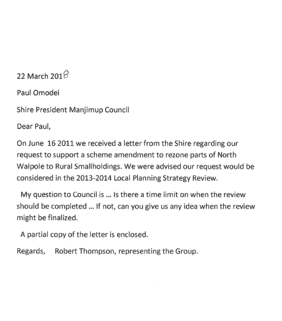

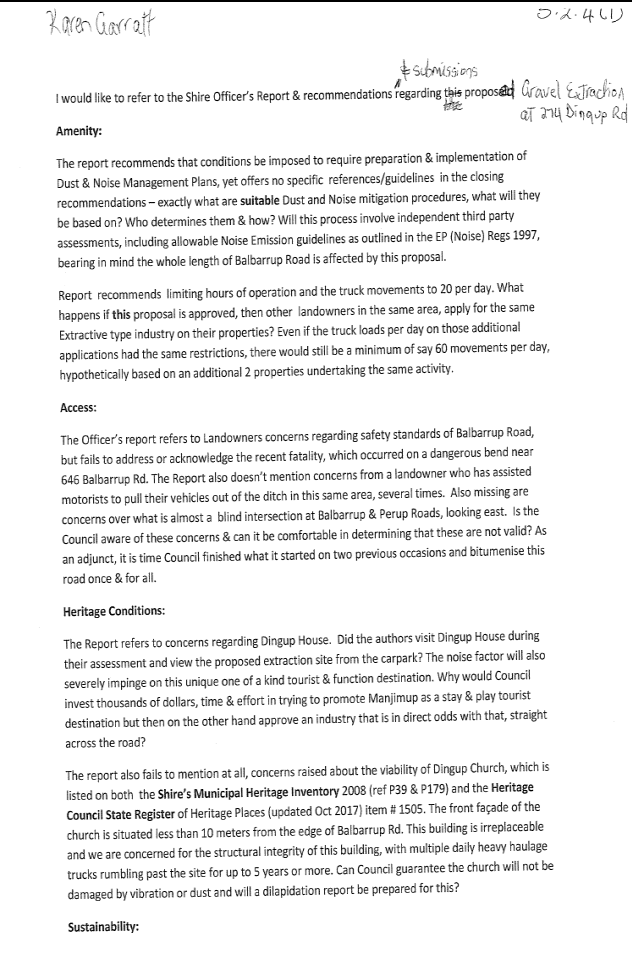
![]()