
MINUTES
Council Meeting
14 September 2017
MINUTES
Council Meeting
14 September 2017
TABLE OF CONTENTS
1. DECLARATION OF OPENING / ANNOUNCEMENT OF VISITORS:
2. ANNOUNCEMENTS BY THE PRESIDENT:
8. MOTIONS OF WHICH PREVIOUS NOTICE HAS BEEN GIVEN: Nil
27143 9.2.1 Quarterly Report March - June 2017 Business
27144 9.3.1 Monthly Financial Activity Statement - July 2017
27145 9.3.2 Adoption of Material Variance / Percentage 2017/2018 Financial Year
27146 9.3.3 Proposed Windy Harbour Lease Transfer - Site 299
27147 9.3.4 Proposed Windy Harbour Lease Transfer - Site 115
27148 9.3.5 Proposed Windy Harbour Lease Transfer - Site 130
27154 9.5.4 Proposed Low-Impact Tourist Accommodation at Lot 8327 (127) Gabbedy Road, Meerup
27157 9.5.7 Proposed Local Scheme Amendment No 21 - Boronia Ridge Estate, Walpole
27158 9.7.1 Proposed Bushfire Risk Management Plan for Shire of Manjimup
27163 9.16.2 Minutes of the Access and Inclusion Advisory Committee Meeting Held 10 August 2017
12. MOTIONS FOR CONSIDERATION AT THE FOLLOWING MEETING: Nil
13. NEW BUSINESS OF AN URGENT NATURE INTRODUCED BY DECISION OF THE MEETING: Nil
14. APPLICATIONS FOR LEAVE OF ABSENCE: Nil
Minutes of the Ordinary Meeting of Council held in the Town Hall, Northcliffe, Thursday, 14 September 2017.
1. DECLARATION OF OPENING / ANNOUNCEMENT OF VISITORS:
The Shire President declared the meeting open at 5.30pm.
2. ANNOUNCEMENTS BY THE PRESIDENT:
The Shire President made the following announcements:
· The Governor Hon. Kerry Sanderson will visit the Shire on 2 November, 2017.
· Kerry Winsor, Director South West Health, will visit on 20 October 2017.
· Congratulations to Pemberton Visitor Centre on winning the WA Regional Tourism Awards 2017 Top Town under 5,000 population and Community Engagement Award.
· Cr Bavich and I attended Rotary and gave a PowerPoint presentation on the Revitalisation Project and economic drivers.
· Attended Sandakan Memorial Service in Boyup Brook.
· Attended the Rotary Anne McKay address by Karl O’Callaghan.
· The nominations for the Shire of Manjimup Local Government Elections, to be held on October 21, 2017, closed at 4pm today and the nominations are as follows:
Ø Central Ward – 7 Nominations
Sam Karamfiles
Carla Logan
Mary Nixon
Mark Rawlings
Paul Matenaar
Paul Omodei
Jayde Salomone
Ø East Ward – 3 Nominations
Timmothy Mearns
Cliff Winfield
Nicholas Hort
Ø West Ward – 2 Nominations
Wade DeCampo
Murray Ventris
Ø Coastal Ward – 1 Nomination
Wendy Eiby – elected unopposed
Ø South Ward – 1 Nomination
David Tapley – elected unopposed
PRESENT:
Councillors
Cr P Omodei (Shire President)
Cr D Bavich
Cr W DeCampo
Cr V Herbert
Cr G Munro
Cr D Tapley
Cr R Taylor
Cr C Winfield
Staff
Mr Andrew Campbell (Chief Executive Officer)
Mr Greg Lockwood (Director Business)
Ms Gail Ipsen Cutts (Director Community Services)
Mr Brian Robinson (Director Development & Regulation)
Mr Michael Leers (Director Works & Services)
Ms Gaye Burridge (Corporate Administration Officer)
Gallery
Colin Crombie
Aaron Turner
Sondra Reader-Bryant
Ros Herbert
Anne O’Donnell
Jenny MacDonald
Carole Perry
Nigel Kelly
Glynne Jones
Elizabeth Lutter
Frances Armstrong
Helen Smith
Murray Ventris
Shane Rudd
Robert Minchin
Laraine Minchin
Ethel Sale
Lyn Corkery
Oona Ormsby
Ken Gwynne
Graeme Robertson
Media
Irene de Haan
3.1 Apologies:
Councillor Carla Logan is an apology for this meeting.
3.2 Leave Of Absence:
Councillors Daubney and Jenkins were granted a Leave of Absence at the 10 August, 2017 Council meeting for this meeting.
The Chief Executive Officer advised that he has received a Financial Interest Declaration from Cr Winfield and a Proximity Interest Declaration from Cr Taylor.
Cr Winfield advised that he has a Financial Interest in Items 9.3.6 and 9.16.1 as his wife is consultant to the project.
Cr Taylor advised that he has Proximity Interest in Item 9.13.1 as he is the owner of land in Margerison Street, Manjimup.
5. PUBLIC QUESTION TIME:
5.1 Response to public questions taken on notice: Nil
5.2 Public Question Time
5.2.1 Graeme Robertson – Sunland Pty Ltd – Item 9.5.7 Proposed Local Scheme Amendment No 21 Boronia Ridge Estate, Walpole.
· Have been developing Boronia Ridge subdivision over the last 17 years.
· Accept Officer’s recommendation except for Point 1 C.
· Blocks are slightly smaller with a total of 44 blocks to be released.
· The release will be done in 4 stages of 11 blocks each.
· Deep sewage will be done for all 44 blocks at one time and all tidied up. It is more economical to do the sewage in one go.
· Thank you for your time and look forward to your support of the item tonight.
5.2.2 Shane Rudd – Northcliffe
· Disappointment at the proposed closure of Loverock Road between Wheatley coast Road and Bebee Road.
· It’s an access that locals have used for a long time and I use myself.
· Important for fire control and fire access.
· There is a Blue gum plantation between Riverway Road and Loverock Road which will be impacted by the closure of Loverock Road. The manager of Bunbury Fibre Exports was unaware of the impending closure. He will be contacting the Shire regarding the closure.
5.2.3 Anne O’Donnell – Northcliffe Community Development.
· The Northcliffe Community Development Group present all new residents with a Welcome Pack which has information on all the available services, businesses and facilities in Northcliffe and also a number of vouchers and tourist information.
· Since its inception in 2006 we have distributed 27 packs.
· At the moment they are going out at the rate of 1 per month which augurs well for Northcliffe.
· We would like to offer the Shire a couple of the Information Booklets put together by the NCD for their use.
· We hope that when there is work to be done in Northcliffe local trades people will be given a preference.
· Earlier in the year I went to the playing oval to collect my grandsons and while the children were playing a Shire worker was spraying the grass.
· There had been no notification to the Recreation Ground Committee that spraying was to be done, and it should not have occurred while children were playing on the oval.
· There needs to be better communication between the Shire and the Recreation Ground Committee.
· I draw your attention to the crest on Richardson Road, outside Mel Armstrong’s property.
· It has been on the list of road issues for quite some time to widen the road both before and after the crest.
· For those who don’t use the road on a regular basis it is dangerous and particularly when you are driving into the sun.
· It is also a bus route.
· I would urge you to make this a priority.
· I love your new dust bins.
5.24 Nigel Kelly – Windy Harbour
· Why have the banks been left exposed, when they put the new road into Windy Harbour a year ago, and not rehabilitated to prevent the erosion by wind and rain?
· It’s an ugly entrance statement to the Community.
· Where the new road meets the existing road near the caravan park needs to be a ‘T’ junction.
· It makes moving around the community very hard.
Response by Paul Omodei: We will take those comments on board and will respond as soon as possible.
5.2.5 Aaron Turner, representing Sondra Reader-Bryant – Item 9.5.5 Proposed small Bar, Holiday Accommodation and Café at Lot 106 (23) Brockman Street, Pemberton.
· I have three questions:
1. What are the proposed opening hours of the bar/restaurant?
2. Under the Liquor Licencing Act, what are the permissible hours of sale of alcohol to the public?
3. Is it reasonable to assume that a bar restaurant, with particular reference to a beer garden, during the summer months, will lend itself to becoming a noisy, potentially unruly, disrupting environment ruining the quiet ambience of a what is mostly a quiet, serene atmosphere in Brockman Street.
Response by Shire President: The answers to your questions are contained in the report to Council, however we will respond to you in writing.
6. PRESENTATIONS:
6.1 Petitions: Nil
6.2 Presentations: Nil
6.3 Deputations Nil
6.4 Delegates’ reports: Nil
6.5 Conference reports: Nil
7. CONFIRMATION OF MINUTES:
|
Moved: Winfield, C Seconded: Bavich, D
That the Minutes of the Ordinary Meeting of the Council held on 24 August 2017 be confirmed. CARRIED: 8/0 |
8. MOTIONS OF WHICH PREVIOUS NOTICE HAS BEEN GIVEN: Nil
10
9.2.1 Quarterly Report March - June 2017 Business
|
PROPONENT |
Shire of Manjimup |
|
OWNER |
Shire of Manjimup |
|
LOCATION / ADDRESS: |
Shire of Manjimup |
|
WARD: |
All |
|
ZONE: |
N/A |
|
DIRECTORATE: |
Business |
|
FILE REFERENCE: |
F160966 |
|
LEGISLATION: |
Nil |
|
AUTHOR: |
Greg Lockwood |
|
DATE OF REPORT: |
1 September 2017 |
|
DECLARATION OF INTEREST: |
Nil |
Background:
A report outlining activities for the quarter ending 30 June 2017 for the Business Directorate is attached.
ATTACHMENT: 9.2.1(1)
PUBLIC Consultation Undertaken:
Nil.
COMMENT (Includes Options):
The report outlines key activities that have occurred for the fourth quarter of 2016/2017. The purpose of the report is to inform Councillors and provide an opportunity to respond to any queries arising from those activities.
STATUTORY ENVIRONMENT:
Nil
Policy / Strategic Implications:
Nil
Organisational risk management:
There is a medium risk with insignificant consequence to the organisation by not regularly reporting the directorate’s progress to Council.
Financial Implications:
Nil
Sustainability:
Environmental: Nil
Economic: Nil
Social: Nil
VOTING REQUIREMENTS: SIMPLE MAJORITY
Officer Recommendation:
That Council receive the June 2017 Quarterly Report – Business as contained in the Attachment 9.2.1(1).
|
Moved: Bavich, D Seconded: Taylor, R
That Council receive the June 2017 Quarterly Report – Business as contained in the Attachment 9.2.1(1). CARRIED: 8/0 |
12
9.3.1 Monthly Financial Activity Statement - July 2017
|
PROPONENT |
Shire of Manjimup |
|
OWNER |
Whole Shire |
|
LOCATION / ADDRESS: |
Whole Shire |
|
WARD: |
Whole Shire |
|
ZONE: |
N/A |
|
DIRECTORATE: |
Business |
|
FILE REFERENCE: |
F160188 |
|
LEGISLATION: |
Local Government Act 1995; Local Government (Financial Management) Regulations 1996 |
|
AUTHOR: |
Greg Lockwood |
|
DATE OF REPORT: |
30 August 2017 |
|
DECLARATION OF INTEREST: |
Nil |
Background:
The Financial Management Regulations require monthly Financial Activity Statement reports to be prepared and presented to Council, containing the following information;
ü Annual budget estimates;
ü Estimates to end of month;
ü Actual expenditure;
ü Actual income;
ü Material variances; and
ü Net current assets.
The Financial Activity Statement report for the period to 31 July 2017 is attached. The report is summarised by Function/Activity with operating comments via department.
ATTACHMENT: 9.3.1(1)
PUBLIC Consultation Undertaken:
Nil
COMMENT (Includes Options):
The financial performance for the Shire of Manjimup to the 31 July 2017 is a projected neutral end of year position.
The start to the 2017/18 financial year has been quiet, this has been due mainly to the adoption of the 2017/18 Shire of Manjimup budget on the 10 August 2017. Until the budget is adopted staff are restricted to non-discretionary operational expenditure only.
Whilst the start of the financial year has been quiet with regards to activity, Officers have been made aware of significant reductions (or reduced increases) in core grant areas.
On the 17 August 2017 Shire staff received from the Department of Local Government and Communities the 2017/18 final Financial Assistance Grant (FAG) allocations. The Shire of Manjimup’s allocation has significantly reduced from the notional figure received back in early July. The major reduction has affected all Local Governments in Western Australia, with the adjustment is due to state population growth being 40,000 less than Commonwealth estimates. The allocation compared to budget is;
|
General Purpose Grant |
2017/18 Allocation |
2017/18 Adopted Budget |
(Shortfall) / Excess |
|
2017/2018 GP Grant Allocation |
2,694,289 |
2,875,357 |
(181,068) |
|
Total General Purpose Grant |
2,694,289 |
2,875,357 |
(181,068) |
|
Road Grant |
|||
|
2017/2018 Road Grant Allocation |
1,345,622 |
1,327,950 |
17,672 |
|
Total Local Roads Grant |
1,345,622 |
1,327,950 |
17,672 |
The overall increase from last year to this year for FAG General Purpose Grant is 0.3%, moving from $2,686,133 to $2,694,289. The FAG Road Grant has an overall increase of 2.34% from $1,314,802 to $1,345,622. This is an extract from the letter received from the Grants commission explaining the reduction in the notional figure given in August; “This is due to new census data becoming available in June, which affected the distribution of Financial Assistance Grant Allocations to the States. The impact is the final cash allocation to Western Australia is lower than originally advised by the Commonwealth in the May estimates”.
The lack of increase to the General purpose grant puts significant pressure on the Shire of Manjimup’s budget going forward as this adjustment is not a one off, but represents the new base grant position moving forward. During the 2017/18 budget process a number of one off projects were deemed a high priority and approved for adoption, these projects will not require a budget allocation in the following years so this should assist in funding the shortfall.
Whilst the effect on the out years of the General Purpose Grant adjustment can be mitigated through budget decisions, an adjustment needs to be made to the 2017/18 Adopted Budget to recognise the $181,068 loss. Options will be investigated by the Senior Management Team and be presented to Council as part of the September 2017 review for approval. This review will be completed after the Shire of Manjimup’s auditors have audited the 2016/17 Annual Financial Accounts and staff can confirm the level of carry forward surplus. The surplus in the June 2017 Monthly Financial Activity Statement was $78,882 which may go some way in helping the situation.
In early August 2017 officers were made aware of a significant reduction in the State Direct Road Grant, this grant assists in funding Road Maintenance. Mainroads WA advised that Manjimup would receive a reduction of $135,390 and also advised that this was a permanent adjustment. The Shire of Manjimup have an allocation of $2,261,212 for core road maintenance, this adjustment represents a reduction of 6% of Road Maintenance. Whilst on the surface this doesn’t seem major, 6% represents nearly one month of road maintenance that will not be funded. Again the Senior Management Team will review options to mitigate the effect of the reduction on road maintenance and the budget and present possible adjustments as part of the September 2017 review.
Other than the grants listed above, no other major discrepancies have come to light in the first month after adopting the 2017/18 budget, and with sound financial management going forward by all departments, Council should be in a neutral or minor surplus position at the 30 June 2018.
STATUTORY ENVIRONMENT:
Section 6.8 Local Government Act and Financial Management Regulation 34.
Policy / Strategic Implications:
Nil
Organisational risk management:
Nil
Financial Implications:
As described in above summary.
Sustainability:
Environmental: Nil
Economic: Nil
Social: Nil
VOTING REQUIREMENTS: SIMPLE MAJORITY
Officer Recommendation:
That Council receive the Monthly Financial Activity Statement Report for July 2017 as per Attachment: 9.3.1 (1).
|
Moved: Taylor, R Seconded: Herbert, V
That Council receive the Monthly Financial Activity Statement Report for July 2017 as per Attachment: 9.3.1 (1).
CARRIED: 8/0 |
15
9.3.2 Adoption of Material Variance / Percentage 2017/2018 Financial Year
|
PROPONENT |
Shire of Manjimup |
|
OWNER |
N/A |
|
LOCATION / ADDRESS: |
N/A |
|
WARD: |
Whole Shire |
|
ZONE: |
N/A |
|
DIRECTORATE: |
Business Directorate |
|
FILE REFERENCE: |
F160188 |
|
LEGISLATION: |
Local Government Act 1995; Local Government (Financial Management) Regulations 1996 |
|
AUTHOR: |
Greg Lockwood |
|
DATE OF REPORT: |
30/08/2017 |
|
DECLARATION OF INTEREST: |
Nil |
Background:
The Local Government Act 1995 and the Local Government (Financial Management) Regulations 1996 require that each financial year a local government is to adopt a materiality level for the purpose of reporting variances in the monthly statement of financial activity.
The Local Government (Financial Management) Regulations 1996 – Financial Reports includes Regulation 34 requiring the local government to prepare each month a statement of financial activity, as set out in the Rate Setting Statement included in the annual budget.
Regulation 34 (1) lists the details to be included in the statement of financial activity, among which are material variances between budget estimates and actual amounts of expenditure, revenue and income to the end of the month to which the statement relates.
Regulation 34 (2) (b) requires an explanation to be provided to Council for each of the material variances shown in each statement of financial activity. Regulation 34 (5) prescribes that each financial year, a local government is to adopt a percentage or value, calculated in accordance with accounting standard AAS 5 (AASB 1031), to be used in statements of financial activity for reporting material variances.
This report recommends the percentage or value to be adopted in determining material variances for the purposes of Regulation 34 of the Local Government (Financial Management) Regulations 1996 as amended, during the current financial year.
PUBLIC Consultation Undertaken:
Nil
COMMENT (Includes Options):
Whilst considering the best method to report material variances to Council it is important to remember that Council has budget categories ranging from $26,559 through to $9,259,665 and the method adopted should extract material variances that are relevant to all levels of budget.
It is recommended that Council adopt a value method, using the following sliding scale based on normal expenditure values.
|
Value Range of Department Operating Budget Total Expenditure |
Reportable Variance Amount |
|
$0 to $300,000 |
$3,000 |
|
$300,001 to $500,000 |
$5,000 |
|
$500,001 to $700,000 |
$7,000 |
|
$700,001 to above |
$10,000 |
Whilst the Value range is determined from expenditure totals, any material variances on income that are greater than the “Reportable Variance Amount” will also be reported.
The recommended Value Method variances listed above have been used for reporting in Monthly Financial Activity Statements the past seven financial years and these values have been found to be effective in measuring what is an important material variance for reporting to Council.
STATUTORY ENVIRONMENT:
Local Government Act 1995, Section 6.8; and Local Government (Financial Management) Regulations 1996, Regulation 34(5).
Policy / Strategic Implications:
Nil
Organisational risk management:
Having clear guidelines to the level of reportable variances reduces risk of misstatements or omissions in the Monthly Financial Activity Statement.
Financial Implications:
Nil
Sustainability:
Environmental: Nil
Economic: Nil
Social: Nil
VOTING REQUIREMENTS: SIMPLE MAJORITY
Officer Recommendation:
That Council adopt the recommended “Value Range” and Reportable Variance Amounts” as following for the 2017/18 Financial Year:
Value Range Of Departmental Operating Reportable Variance Budget Total Expenditure Amount
$0 to $300,000 $3,000
$300,001 to $500,000 $5,000
$500,001 to $700,000 $7,000
$700,001 to above $10,000
|
Moved: Herbert, V Seconded: Tapley, D
That Council adopt the recommended “Value Range” and Reportable Variance Amounts” as following for the 2017/18 Financial Year: Value Range Of Departmental Operating Reportable Variance Budget Total Expenditure Amount $0 to $300,000 $3,000 $300,001 to $500,000 $5,000 $500,001 to $700,000 $7,000 $700,001 to above $10,000
CARRIED: 8/0 |
18
9.3.3 Proposed Windy Harbour Lease Transfer - Site 299
|
PROPONENT |
Wayne Hughes & Michael Collins Malcolm Collins & Tracy Gibellini |
|
OWNER |
Crown (Management Order to Shire) |
|
LOCATION / ADDRESS: |
Site 299 Macallen Way, Windy Harbour |
|
WARD: |
Coastal |
|
ZONE: |
Special Use Zone No 5 |
|
DIRECTORATE: |
Business |
|
FILE REFERENCE: |
F170394 |
|
LEGISLATION: |
Local Government Act 1995 Land Administration Act 1997 |
|
AUTHOR: |
Jasmine Bamess |
|
DATE OF REPORT: |
23 August 2017 |
|
DECLARATION OF INTEREST: |
Nil |
Background:
The Shire of Manjimup has the Management Order for Reserve 38881 Windy Harbour for the purpose of “Recreation, Camping, Caravan Park and Holiday Cottages” with the power to lease, subject to the consent of the Minister for Lands. Since 2001 Council has been granting 20 year leases for designated lease sites.
A 20 year lease over Site 299 to Wayne Hughes and Michael Collins commenced 20 November 2008. They have requested to transfer the lease to Malcolm Collins and Tracy Gibellini.
PUBLIC Consultation Undertaken:
Nil
COMMENT (Includes Options):
The current lease to expire November 2028 has 11 years remaining. The lease will be transferred with this remaining term.
In accordance with Policy 3.4.2 a general condition assessment for each lease site is to be undertaken once every five years and work orders issued where required. A general condition assessment for Site 299 was undertaken in 2015 with it being in an overall satisfactory condition and no work orders issued.
STATUTORY ENVIRONMENT:
A transfer/assignment of an existing lease does not constitute a ‘disposition of property’ from the Local Government’s point of view. Windy Harbour leases are also considered residential and therefore exempt from s3.58 (Disposing of Property) of the Local Government Act 1995 under s30(2)(g) of the Local Government (Functions and General) Regulations 1996.
Each lease and any subsequent transfers must receive the approval of the Minister for Lands in accordance with section 18 of the Land Administration Act 1997.
Policy / Strategic Implications:
The lease transfer is in accordance with Council Policy 3.4.2 Windy Harbour Leases.
Organisational risk management:
Nil
Financial Implications:
Leaseholders are required to pay Council’s lease preparation fee to offset the administration costs of preparing and lodging each lease or lease transfer.
Sustainability:
Environmental: Nil
Economic: Nil
Social: Nil
VOTING REQUIREMENTS: SIMPLE MAJORITY
Officer Recommendation:
That Council approve the transfer the lease over Site 299 Windy Harbour from Wayne Hughes and Michael Collins to Malcolm Collins and Tracy Gibellini as tenants in common, subject to consent from the Minister for Lands.
|
Moved: Munro, G Seconded: Tapley, D
That Council approve the transfer the lease over Site 299 Windy Harbour from Wayne Hughes and Michael Collins to Malcolm Collins and Tracy Gibellini as tenants in common, subject to consent from the Minister for Lands. CARRIED: 8/0 |
20
9.3.4 Proposed Windy Harbour Lease Transfer - Site 115
|
PROPONENT |
Millicent Halma Helene Halma, Margaret Dye and Allen Maynard |
|
OWNER |
Crown (Management Order to Shire) |
|
LOCATION / ADDRESS: |
Site 115 Windy Harbour Rd, Windy Harbour |
|
WARD: |
Coastal |
|
ZONE: |
Special Use Zone No 5 |
|
DIRECTORATE: |
Business |
|
FILE REFERENCE: |
F160926 |
|
LEGISLATION: |
Local Government Act 1995 Land Administration Act 1997 |
|
AUTHOR: |
Jasmine Bamess |
|
DATE OF REPORT: |
30 August 2017 |
|
DECLARATION OF INTEREST: |
Nil |
Background:
The Shire of Manjimup has the Management Order for Reserve 38881 Windy Harbour for the purpose of “Recreation, Camping, Caravan Park and Holiday Cottages” with the power to lease, subject to the consent of the Minister for Lands. Since 2001 Council has been granting 20 year leases for designated lease sites.
Millicent Halma has an annual lease over Site 115. She has requested to transfer the lease to her family, Helene Halma, Margaret Dye and Allen Maynard, with a 20 year lease to be granted.
PUBLIC Consultation Undertaken:
Nil
COMMENT (Includes Options):
In accordance with Policy 3.4.2 a general condition assessment for each lease site is to be undertaken once every five years and work orders issued where required. A general condition assessment for Site 115 was undertaken in 2016 with it being in an overall satisfactory condition.
STATUTORY ENVIRONMENT:
A transfer/assignment of an existing lease does not constitute a ‘disposition of property’ from the Local Government’s point of view. Windy Harbour leases are also considered residential and therefore exempt from s3.58 (Disposing of Property) of the Local Government Act 1995 under s30(2)(g) of the Local Government (Functions and General) Regulations 1996.
Each lease and any subsequent transfers must receive the approval of the Minister for Lands in accordance with section 18 of the Land Administration Act 1997.
Policy / Strategic Implications:
The transfer and granting a new 20 year lease is in accord with Council Policy 3.4.2 Windy Harbour Leases.
Organisational risk management:
Nil
Financial Implications:
Leaseholders are required to pay Council’s lease preparation fee to offset the administration costs of preparing and lodging each lease, lease surrender or lease transfer.
Sustainability:
Environmental: Nil
Economic: Nil
Social: Nil
VOTING REQUIREMENTS: SIMPLE MAJORITY
Officer Recommendation:
That Council:
1. Terminate, by mutual consent, the annual lease over Site 115 Windy Harbour between the Shire of Manjimup and Millicent Mary Halma; and
2. Approve a 20 year lease over Site 115 Windy Harbour between the Shire of Manjimup and Helene Halma, Margaret Dye and Allen Maynard as tenants in common of equal shares, subject to approval from the Minister for Lands.
|
Moved: Munro, G Seconded: Winfield, C
That Council: 1. Terminate, by mutual consent, the annual lease over Site 115 Windy Harbour between the Shire of Manjimup and Millicent Mary Halma; and 2. Approve a 20 year lease over Site 115 Windy Harbour between the Shire of Manjimup and Helene Halma, Margaret Dye and Allen Maynard as tenants in common of equal shares, subject to approval from the Minister for Lands.
CARRIED: 8/0 |
22
9.3.5 Proposed Windy Harbour Lease Transfer - Site 130
|
PROPONENT |
Gary Shearer and Kerrie Shearer Griffith and Susan Roberts |
|
OWNER |
Crown (Management Order to Shire) |
|
LOCATION / ADDRESS: |
Site 130 Windy Harbour Road, Windy Harbour |
|
WARD: |
Coastal |
|
ZONE: |
Special Use Zone No 5 |
|
DIRECTORATE: |
Business |
|
FILE REFERENCE: |
F160943 |
|
LEGISLATION: |
Local Government Act 1995 Land Administration Act 1997 |
|
AUTHOR: |
Jasmine Bamess |
|
DATE OF REPORT: |
30 August 2017 |
|
DECLARATION OF INTEREST: |
Nil |
Background:
The Shire of Manjimup has the Management Order for Reserve 38881 Windy Harbour for the purpose of “Recreation, Camping, Caravan Park and Holiday Cottages” with the power to lease, subject to the consent of the Minister for Lands. Since 2001 Council has been granting 20 year leases for designated lease sites.
Gary Shearer and Kerrie Shearer have a 20 year lease over Site 130, which commenced 26 September 2002. At the meetings of 20 April 2017 and 11 May 2017 Council approved transfer of the lease for proposed sales, however both contracts for sale were terminated.
A new contract for sale is now in place for the lease of Site 130 to be sold to Griffith and Susan Roberts.
PUBLIC Consultation Undertaken:
Nil
COMMENT (Includes Options):
In accordance with Policy 3.4.2 a general condition assessment for each lease site is to be undertaken once every five years and work orders issued where required. A general condition assessment for Site 130 was undertaken in September 2015 with it being in a good overall condition with no work orders issued.
At the meeting of 26 May 2016 Council approved a request to transfer the lease for Site 130 from Gary Shearer and Kerrie Shearer as joint tenants to Kerrie Shearer as sole tenant. However this transfer has not occurred due to complications related to the mortgage over the lease and the request is now superseded by the contract for sale.
The recommendation includes rescinding the previous three decisions relating to the transfer and proposed sales of the lease prior to Council approving the transfer for the current contract for sale.
The current lease to expire September 2022 has five years remaining. A full 20 year lease term has been requested for the purchasers in the contract conditions.
Griffith and Susan Roberts currently have a 20 year lease over Site 27 Windy Harbour also. Council’s leasing policy does not have any restrictions on people holding multiple Windy Harbour leases.
STATUTORY ENVIRONMENT:
A transfer/assignment of an existing lease does not constitute a ‘disposition of property’ from the Local Government’s point of view. Windy Harbour leases are also considered residential and therefore exempt from s3.58 (Disposing of Property) of the Local Government Act 1995 under s30(2)(g) of the Local Government (Functions and General) Regulations 1996.
Each lease and any subsequent transfers must receive the approval of the Minister for Lands in accordance with section 18 of the Land Administration Act 1997.
Policy / Strategic Implications:
The lease transfer and granting a new 20 year term is in accord with Council Policy 3.4.2 Windy Harbour Leases.
Organisational risk management:
Nil
Financial Implications:
Leaseholders are required to pay Council’s lease preparation fee to offset the administration costs of preparing and lodging each lease, lease surrender or lease transfer.
Sustainability:
Environmental: Nil
Economic: Nil
Social: Nil
VOTING REQUIREMENTS: ABSOLUTE MAJORITY
Officer Recommendation:
Step 1
consent in accordance with the local government (administration) regulations 1996
The following four Councillors consent to the consideration of a Motion to rescind Council’s decisions of 26 May 2016, 20 April 2017 and 11 May 2017 relating to the lease for Site 130 Windy Harbour:
Cr ________________________________
Cr________________________________
Cr________________________________
Cr________________________________
STEP 2 (If Consent is granted from Step 1 – Absolute Majority required)
Motion:
That Council revoke its decisions in relation to item 9.3.5 on 26 May 2016, item 9.3.2 on 20 April 2017 and item 9.3.3 on 11 May 2017.
STEP 3 (Only if Step 2 is carried by Absolute Majority)
MOTION:
That Council, subject to the sale taking affect:
1. Terminate, by mutual consent, the lease over Site 130 Windy Harbour between the Shire of Manjimup and Gary Charles Shearer and Kerrie Shearer; and
2. Approve a 20 year lease over Site 130 Windy Harbour between the Shire of Manjimup and Griffith and Susan Roberts as joint tenants, subject to approval of the Minister for Lands.
|
Step 1 consent in accordance with the local government (administration) regulations 1996
The following four Councillors consent to the consideration of a Motion to rescind Council’s decisions of 26 May 2016, 20 April 2017 and 11 May 2017 relating to the lease for Site 130 Windy Harbour:
Cr Robert Taylor
Cr David Tapley
Cr Graham Munro
Cr Cliff Winfield
STEP 2 (If Consent is granted from Step 1 – Absolute Majority required)
Moved: Munro, G Seconded: Taylor, R
That Council revoke its decisions in relation to item 9.3.5 on 26 May 2016, item 9.3.2 on 20 April 2017 and item 9.3.3 on 11 May 2017. CARRIED: 8/0 STEP 3 (Only if Step 2 is carried by Absolute Majority) MOTION:
Moved: Munro, G Seconded: Winfield, C
27149 That Council, subject to the sale taking affect: 1. Terminate, by mutual consent, the lease over Site 130 Windy Harbour between the Shire of Manjimup and Gary Charles Shearer and Kerrie Shearer; and 2. Approve a 20 year lease over Site 130 Windy Harbour between the Shire of Manjimup and Griffith and Susan Roberts as joint tenants, subject to approval of the Minister for Lands. CARRIED: 8/0
|
26
Cr Winfield declared a Financial Interest in this Item as his wife is consultation to the project. Cr Winfield did not speak or vote on the matter and left the Chamber at 5.51pm.
ATTACHMENT
9.3.6 Proposed Budget Adjustment - Revitalisation of Manjimup's Town Centre - Stage 2 Funding Reduction
|
PROPONENT |
Shire of Manjimup |
|
OWNER |
Shire of Manjimup |
|
LOCATION / ADDRESS: |
Manjimup Town Centre |
|
WARD: |
Central |
|
ZONE: |
Town Centre |
|
DIRECTORATE: |
Business |
|
FILE REFERENCE: |
F160948 |
|
LEGISLATION: |
Local Government Act 1995 |
|
AUTHOR: |
Greg Lockwood |
|
DATE OF REPORT: |
1/09/2017 |
|
DECLARATION OF INTEREST: |
Nil |
Background:
The Revitalisation of Manjimup’s Town Centre Project Stage 2 is an extension of the original Royalties for Regions “SuperTown” business case submission by the Shire of Manjimup with the original project divided into three separate stages. Only Stage 1 of the three part program was funded in 2012.
In 2015 the South West Development Commission approached the Shire of Manjimup requesting that a business case be prepared for the Revitalisation of Manjimup’s Town Centre Stage 2. Utilising the principles of the Manjimup SuperTown Growth Plan and the Revitalisation of Manjimup’s Town Centre Stage 1 Business Case, in consultation with Council, the Chief Executive Officer produced the Revitalisation of Manjimup’s Town Centre Business Case Stage 2 in collaboration with the South West Development Commission for submission to the State in October 2015.
In May 2016 the Shire of Manjimup received advice of the successful grant application for Stage 2 from the Royalties for Regions “Growing Our South” program of $22,290,000 and subsequent Financial Assistance Agreement (FAA) was signed on 23 May 2016.
A review of the Royalties for Regions (RfR) program buy the new State Government in 2017 saw all projects throughout the state under scrutiny for possible savings to assist with budgetary issues.
At the Council meeting on the 24 August 2017 a report was presented to Council post this review process and after receipt of correspondence received on 9 August 2017 that the Shire of Manjimup received confirmation that $3,000,000 was required to be returned to the State Government from the Royalties for Regions component of the Revitalisation of Manjimup’s Town Centre Project.
The purpose of this agenda item is to amend the Manjimup Town Centre Revitalisation project budget taking into account the $3,000,000 reduction, to recognise other grant funding received and to seek an amendment from the Department of Regional Development to reflect the proposed changes in the FAA.
PUBLIC Consultation Undertaken:
Nil
COMMENT (Includes Options):
The purpose of this agenda item is to amend the Manjimup Town Centre Revitalisation project budget taking into account the $3,000,000 reduction, to recognise other grant funding received and to seek an amendment from the Department of Regional Development to reflect the proposed changes in the FAA.
The current FAA recognises a total budget of $30,462,000 with funding from the following sources;
· Royalties for Regions - $22,290,000;
· Federal Government - $3,800,000;
· South West Development Commission (SWDC) - $1,800,000 (Gifted exhibit, non-cash)
· Mainroads WA - $700,000;
· Lotterywest - $210,000;
· Bike West - $50,000;
· Department of Sport and Recreation (DSR) - $50,000; and
· Shire of Manjimup - $1,562,000
ATTACHMENT: 9.3.6(1)
Firstly as part of this process a review of the FAA as it sits pre the $3,000,000 withdrawal needs to occur so it can be understood how these initial adjustments will affect the overall delivery of the project. The main adjustments required are;
· Reduction of Federal grant for the South West Energy Experience (SWEE) from $3,800,000 to $2,677,725 – grant would only fund building component;
· Reduction of SWDC non cash contribution from $1,800,000 to $724,875 due to the write down of the value of the SWEE exhibit;
· Increase in Lotterywest funding from $210,000 to $1,168,869 due to successful grant application for both the Sandra Donovan Sound Shell and the Manjimup Rec Plaza;
· Removal of Bikewest funding of $50,000 – project did not meet grant criteria; and
· Removal of DSR Funding of $50,000 – project did not meet grant criteria.
ATTACHMENT: 9.3.6(2)
Senior Management Team met on the 23 August 2017 to review the project and the components to assess where reductions could occur without compromising the delivery and ultimately the long term outcomes of the project. From this meeting the $3,000,000 reduction is proposed to come from the following areas;
· Component 2 – Transform Manjimup Timber Park - $600,000 RfR reduction;
· Component 3 – Create Townsite wide Linear Park - $600,000 RfR reduction;
· Component 5 – Create Investment ready Hotel Site - $200,000 RfR reduction;
· Component 7 – Undertake an Array of Mottram St / SW Hwy, improve safety - $1,000,000 RfR reduction; and
· Recognise Interest $600,000.
ATTACHMENT: 9.3.6(3)
STATUTORY ENVIRONMENT:
Local Government Act 1995 requires budgets to be set by Council by absolute majority.
Policy / Strategic Implications:
There are no Policy or Strategic implications to this agenda item.
Organisational risk management:
It is not expected that the Shire of Manjimup will be exposed to any additional financial or reputation risk as the Revitalisation of Manjimup’s Town Centre Project is still expected to be delivered to completion.
Financial Implications:
On all capital projects there is an ongoing maintenance consequence and this will be required to be factored in to future annual budgets. The Shire’s strategic planning including the Long Term Financial Plan is the correct framework to adequately capture and plan for future maintenance obligations.
Sustainability:
Environmental: Nil
Economic: As indicated in the report
Social: Nil
VOTING REQUIREMENTS: ABSOLUTE MAJORITY
Officer Recommendation:
That Council
1) Amend the 2017/2018 annual budget to recognise the $3,000,000 reduction in Royalties for Regions - Manjimup Town Centre Revitalisation and other minor amendments to the project as per the table below;
|
Allocation |
Current Budget |
Proposed Budget |
Variance |
|
Grant – South West Development Commission |
(1,075,125) |
0 |
1,075,125 |
|
Grant – Federal Grant Funding |
(3,800,000) |
(2,677,725) |
1,122,275 |
|
Grant – Department of Sport & Recreation |
(50,000) |
0 |
50,000 |
|
Grant – Regional Bike Network |
(50,000) |
0 |
50,000 |
|
Grant - Lotterywest |
(210,000) |
0 |
210,000 |
|
711 – 719 Manjimup Town Centre Revitalisation Stage 2 |
26,386,936 |
23,879,536 |
(2,507,400) |
|
2016/2017 Carried Forward Surplus |
(18,815,322) |
(15,215,322) |
3,000,000 |
|
2016/2017 Restricted Cash – Interest Western Australian Treasury |
0 |
(600,000) |
(600,000) |
|
711 – 719 Manjimup Town Centre Revitalisation Stage 2 |
23,879,536 |
21,479,536 |
(2,400,000) |
|
Net |
|
|
$0 |
2) Authorise the Chief Executive to seek an amendment to the Financial Assistance Agreement to reflect the required changes.
|
Moved: DeCampo, W Seconded: Taylor, R
That Council 1) Amend the 2017/2018 annual budget to recognise the $3,000,000 reduction in Royalties for Regions - Manjimup Town Centre Revitalisation and other minor amendments to the project as per the table below;
2) Authorise the Chief Executive to seek an amendment to the Financial Assistance Agreement to reflect the required changes.
CARRIED: 7/0 |
31
Cr Winfield returned to Chamber at 5.53pm.
ATTACHMENT
9.5.1 Proposed Remote Signage on Location 4441 Conte Road, Collins and Lot 26 Vasse Highway, Pemberton
|
PROPONENT |
Mr DG Webster & Ms KG Barrett-Lennard |
|
OWNER |
Mr J Forrest; Mr AT & Ms A Ailakis |
|
LOCATION / ADDRESS: |
Location 4441 Conte Road, Collins and Lot 26 Vasse Highway, Pemberton |
|
WARD: |
West |
|
ZONE: |
Parks and Recreation; General Agriculture |
|
DIRECTORATE: |
Development and Regulation |
|
FILE REFERENCE: |
DA17/171, P56648; DA17/170, P57650 |
|
LEGISLATION: |
Planning and Development Act 2005 |
|
AUTHOR: |
Kaylene Roberts |
|
DATE OF REPORT: |
17/08/2017 |
|
DECLARATION OF INTEREST: |
Nil |
Background:
Two applications for development approval have been received seeking approval for two Advertisements, being Remote Signs. Approval is being sought to replace two existing signs relating to now closed businesses, with signage for:
a) Promotion of a food delivery service to the community of Pemberton on the existing signage at Location 4441 Conte Road, Collins; and
b) Promotion of “People and Parcel Movers”, which also undertakes food deliveries. If approved this sign will be located on existing signage at Lot 26 Vasse Highway, Pemberton.
A copy of the submitted applications are shown below.
ATTACHMENT: 9.5.1(1)
Location Plan 1 – Collins
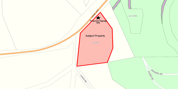
Location Plan 2 – Pemberton
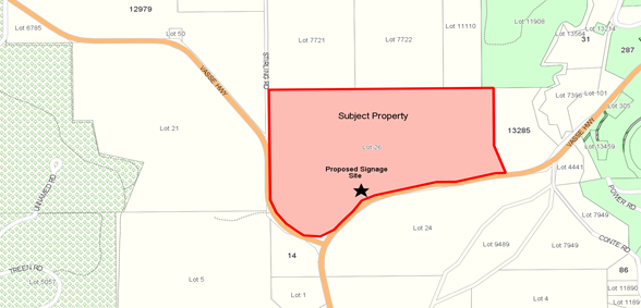
Location 4441 Conte Road, Collins has a total area of 2.75 ha and Lot 26 Vasse Highway, Pemberton has a total area of 80.8ha with both properties being predominately being used for agricultural pursuits.
Whilst the signage is being proposed to replace existing, outdates signs, using the current sign framework, Council is requested to determine the applications as approval requires a variation of current Council Policy relating to advertising signage.
PUBLIC Consultation Undertaken:
No public consultation was undertaken. However, as the remote signage is located abutting a highway, the comment of Main Roads WA (MRWA) were sought. A copy of the advice received from MRWA is shown attached and is discussed in the Comment section below.
ATTACHMENT: 9.5.1(2)
COMMENT (Includes Options):
The provisions of Local Planning Scheme No 4 (the Scheme) include the properties as being within the “General Agriculture” and “Parks and Recreation” Zones. As prescribed by clause 5.29 of the Scheme:
“the erection, placement and display of advertisements and the use of land and buildings for that purpose is development within the definition of the Planning and Development Act 2005 and requires the planning approval of the local government in accordance with the provisions of Part9 of the Scheme, unless it is an exempted advertisement as listed in Schedule 15.”
Council adopted Local Planning Policy No 6.1.4 – Advertisements on 8 December 2016 in order to guide officers in assessing applications for Advertising Signage.
The signs subject of this application are considered to be generally compliant with the Advertisement Policy except that they are not associated with a tourist business. Further guidance is provided below to assist Council in determining the application.
LPS4 6.1.4 – Advertisements
The Policy, which applies to all advertisements being constructed on land in all Scheme zones prescribes the development criteria to be used when assessing applications for Remote Signs. Assessment of the application against this criteria confirms that the proposal, complies with the criteria, except for the following requirement:
a) The remote sign is associated with a tourist-related business or a business that provides goods and services to the travelling public that has been approved by the local government.
As the applicant does not operate a tourist related business, neither sign as proposed complies with the above. However, the sign relating to “People Movers” could be considered as a tourist related business given that the services could be used by the travelling public.
In each case the landowners have given permission for the applicant to use the existing frames and stands for the signs.
Submission Received
MRWA have assessed the proposal against their policy relating to Application Guidelines for Advertising Signs. They have stated they have no objection to the proposed signage and locations based on their current policy and application guidelines for advertising signs.
Matters to be Considered
In considering application for planning approval, clause 10.2 of the Scheme requires that Council have due regard to various matters. These matters include but are not limited to:
(v) any relevant policy or strategy of the Commission and any relevant policy adopted by the Government of the State;
(vi) the local government’s adopted Local Planning Strategy and any local Planning Policy adopted by the local government under clause 2.4…..,
(x) the compatibility of the use or development with its setting including the potential impact on the use and enjoyment of adjacent and nearby land and taking into consideration any Special Control Area;
(xv) the preservation of the amenity of the locality.
Given that MRWA has not raised an objection to the proposal, the application is deemed to be consistent with requirement (v) above.
With regards to the preservation of the amenity of the locality, Local Planning Policy No 6.3.5 stipulates minimum separation distances between Remote Signs in order to limit the impact on the amenity of the area and ensure the potential for driver distraction is minimised. The submitted applications comply with these requirements.
Conclusion
The proposed variations have been assessed against clause 10.2 of the Scheme. The assessment has found that the variations could be approved by Council if it chooses to exercise its discretion.
STATUTORY ENVIRONMENT:
Planning and Development Act 2005 and Shire of Manjimup Local Planning Scheme No. 4.
Policy / Strategic Implications:
Compliance with Local Planning Policy LPS4 6.1.4 Advertisements is discussed as above.
Organisational risk management:
Nil.
Financial Implications:
The appropriate fees have been paid by the applicant.
Sustainability:
Environmental: Nil.
Economic: Nil.
Social: Nil.
VOTING REQUIREMENTS: SIMPLE MAJORITY
Officer Recommendation:
That Council in accordance with Part 10 of Shire of Manjimup Local Planning Scheme No. 4 grants planning approval for the remote signage at Location 4441 Conte Road, Collins (TP159/2017) and Lot 26 Vasse Highway, Pemberton (TP160/2017) in accordance with the plans as attached at 9.5.1(1) and subject to the following conditions:
1. The development hereby approved must be carried out generally in accordance with the plans and specifications submitted with the application and these shall not be altered and/or modified without the prior knowledge and written consent from the Shire of Manjimup;
2. The remote signs are to display the authorisation of the Shire of Manjimup.
|
Moved: DeCampo, W Seconded: Herbert, V
That Council in accordance with Part 10 of Shire of Manjimup Local Planning Scheme No. 4 grants planning approval for the remote signage at Location 4441 Conte Road, Collins (TP159/2017) and Lot 26 Vasse Highway, Pemberton (TP160/2017) in accordance with the plans as attached at 9.5.1(1) and subject to the following conditions: 1. The development hereby approved must be carried out generally in accordance with the plans and specifications submitted with the application and these shall not be altered and/or modified without the prior knowledge and written consent from the Shire of Manjimup; 2. The remote signs are to display the authorisation of the Shire of Manjimup. CARRIED: 8/0 |
36
9.5.2 Retrospective Application for Change of Use (Domestic Outbuilding to Ancillary Accommodation) at Lot 38 (246) Jacksonii Avenue, Walpole
|
PROPONENT |
JM Beaumont & CR Cann |
|
OWNER |
RJ Carter & SR Cochrane |
|
LOCATION / ADDRESS: |
Lot 38 (246) Jacksonii Avenue, Walpole |
|
WARD: |
South |
|
ZONE: |
Rural Residential |
|
DIRECTORATE: |
Development and Regulation |
|
FILE REFERENCE: |
DA17/73, P50203 |
|
LEGISLATION: |
Planning and Development Act 2005, Shire of Manjimup Local Planning Scheme No.4. |
|
AUTHOR: |
Jason Giadresco |
|
DATE OF REPORT: |
29/08/2017 |
|
DECLARATION OF INTEREST: |
Nil |
Background:
Council is requested to consider an application for a Change of Use, converting an existing Domestic Outbuilding to an Ancillary Accommodation Unit at Lot 38 (246) Jacksonii Avenue, Walpole. Plans as provided by the proponent are attached.
ATTACHMENT: 9.5.2(1)
Location Plan
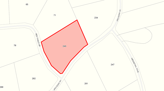
It was noted by Shire officers during the sale of the property in March 2017 that the Domestic Outbuilding on the property was being used for habitable purposes without approval. Shire officers contacted the landowner at the time to make retrospective application for development approval to formalise the use of the Domestic Outbuilding as Ancillary Accommodation.
Whilst Shire officers initially accepted the retrospective application for development approval, it was determined further detail and fee payment was required to process the application. The proponent has been contacted a number of times since April 2017 to provide the information and fee, but has not provided Shire officers with a response.
Council is now requested to formally refuse the application.
PUBLIC Consultation Undertaken:
Nil.
COMMENT (Includes Options):
The provisions of Local Planning Scheme No 4 (the Scheme) include the subject land within the Rural-Residential Zone. As identified within the Scheme, “Ancillary Accommodation” is a “D” use within the Rural-Residential Zone. That is a use which is “not permitted unless the local government has exercised its discretion by granting approval.”
The Scheme identifies that the term “Ancillary Accommodation”, has the same definition applied by the Residential Design Codes of Western Australia, being “Self-contained dwelling on the same lot as a single house which may be attached to, integrated with or detached from the single house.”
To guide Council in the determination of the application the following comments are offered:
Application Detail
In accordance with Part 9 of the Scheme, to be valid an application for planning approval must be accompanied by:
a) Payment of the required fee;
b) At Scale plans, providing a satisfactory level of detail.
In this case, the application was not accompanied by payment of the required fee and the submitted plans were insufficient to allow for proper and orderly assessment of the application.
Attempts to Contact Proponent
The Shire’s Statutory Planning office has made a number of attempts to contact the proponent, with the view to receiving further information to process the application. A number of phone calls have been made, and two formal letters detailing the further information required dated 3 April 2017 and 4 August 2017 sent to the proponent. At the time of writing no written or verbal response has been received. The letters requesting further information are attached.
ATTACHMENT: 9.5.2(2)
Given the lack of response, Shire officers propose to deem that the application is not valid in its current form.
Outstanding Illegal Development
Whilst deeming the application is not valid resolves the status of the application, the result is that the unauthorised development issue has not been resolved.
It is not clear to Shire officers whether the new landowners at 246 Jacksonii Avenue are using the Domestic Outbuilding as Ancillary Accommodation without approval, or are aware that approval of the use of building in that manner is required. To resolve the non-compliance, Shire officers will contact the new landowners to determine their intent with regard to the use of the building.
Given that the current owners were no involved in establishing the unauthorised development, it is recommended that no action be taken until such time as the current owners intent is known.
Concluding Remarks
It is the opinion of Shire officers that despite repeated attempts to make contact with the proponent, there appears little inclination to provide the further information required to adequately assess the application given the sale of the property to new owners. For this reason it is recommended that the application be deemed to be invalid and that the matter be addressed through consultation with the new owners.
STATUTORY ENVIRONMENT:
Planning and Development Act 2005 and Shire of Manjimup Local Planning Scheme No. 4.
Policy / Strategic Implications:
Nil.
Organisational risk management:
Nil.
Financial Implications:
Nil.
Sustainability:
Environmental: Nil.
Economic: Nil.
Social: Nil.
VOTING REQUIREMENTS: SIMPLE MAJORITY
Officer Recommendation:
That Council:
1. In accordance with Part 9 of Shire of Manjimup Local Planning Scheme No.4 deem that the application for planning approval to a Change of Use from domestic outbuilding to ancillary accommodation at Lot 38 (246) Jacksonii Avenue, Walpole be deemed as invalid, based on the following:
· Non-payment of the required $441 retrospective development application fee;
· Non-provision of sufficient information to make adequate assessment of the retrospective Change of Use.
2. Defer any action in respect of the unauthorised ancillary accommodation at Lot 38 (246) Jacksonii Avenue, Walpole pending liaison with the new/current owners of the land.
|
Moved: Tapley, D Seconded: DeCampo, W
That Council: 1. In accordance with Part 9 of Shire of Manjimup Local Planning Scheme No.4 deem that the application for planning approval to a Change of Use from domestic outbuilding to ancillary accommodation at Lot 38 (246) Jacksonii Avenue, Walpole be deemed as invalid, based on the following: · Non-payment of the required $441 retrospective development application fee; · Non-provision of sufficient information to make adequate assessment of the retrospective Change of Use. 2. Defer any action in respect of the unauthorised ancillary accommodation at Lot 38 (246) Jacksonii Avenue, Walpole pending liaison with the new/current owners of the land. CARRIED: 8/0 |
40
9.5.3 Proposed Low-Impact Tourist Accommodation (Short Stay) at Lot 8200 (379) Green Road, Channybearup
|
PROPONENT |
MJ Muir & CJ Anderson |
|
OWNER |
MJ Muir & CJ Anderson |
|
LOCATION / ADDRESS: |
Lot 8200 (379) Green Road, Channybearup |
|
WARD: |
West |
|
ZONE: |
Priority Agriculture |
|
DIRECTORATE: |
Development and Regulation |
|
FILE REFERENCE: |
DA17/179, P51680 |
|
LEGISLATION: |
Planning and Development Act 2005, Shire of Manjimup Local Planning Scheme No.4 |
|
AUTHOR: |
Jason Giadresco |
|
DATE OF REPORT: |
29/08/2017 |
|
DECLARATION OF INTEREST: |
Nil |
Background:
Council is requested to consider an application for Low Impact Tourist Accommodation (Short Stay) at Lot 8200 (379) Green Road, Channybearup. Location, site and development plans of the proposal are attached.
ATTACHMENT: 9.5.3(1)
Location Plan
Lot 8200 is 31.4ha property located on the north side of Green Road, approximately 16 kilometres from the Pemberton Townsite by road via Vasse Highway. Currently the site contains a dwelling, shed, 2 dams and a building previously used for habitable purposes.
The application proposes the conversion of an existing building to “Holiday Accommodation/Guest Accommodation”. If approved, the building will have two bedrooms and be self-contained. Two (2) car parking spaces are available for vehicles and a maximum of 4 persons are proposed to be accommodated at any one time. The owners who reside on site will manage the accommodation.
Council is requested to determine the application as the proposal is for a discretionary use that may only be determined by Council.
PUBLIC Consultation Undertaken:
The application was advertised for a 14 day period in accordance with clause 9.6 of the Scheme. No submissions were received from adjoining neighbours. Parking space to two vehicles has been indicated.
COMMENT (Includes Options):
In accordance with the provisions of the Shire of Manjimup Local Planning Scheme No 4 (the Scheme), the proposed use is best classified as Holiday Accommodation – Low Impact Tourist Accommodation. The Scheme defines Holiday Accommodation has land and buildings providing facilities for tourist and travellers, including chalets, cabins, farm stay, bed and breakfast, camping grounds, caravan parks and motels, none of which is occupied by the tenant for a period of more than three months in any one calendar year”.
The provisions of the Scheme, include the subject land within the ‘Priority Agriculture’ Zone. Holiday Accommodation – Low Impact Tourist Accommodation is an ‘A’ use within the Priority Agriculture Zone. That is a use which is not permitted unless approved by Council after advertising.
To assist Council in determining the application, the following comments are offered:
Proposal Details
The proposed Low Impact Tourist Accommodation building will:
· accommodate a maximum of 4 persons at any one time;
· be supplied with water from the existing 90,000 on-site tank, treated to a potable standard;
· be served by 2 parking bays located beneath the raised holiday accommodation; and
· be managed in accordance with the details in the Management Plan provided.
Assessment of the proposal confirms that the proposed development complies with all scheme requirements for Holiday Accommodation – Low Impact Tourist Accommodation, provided it is not occurred by any person for more than 3 months in any 12 month period.
Setbacks
As the proposal relates to existing development on the site, no further assessment of setbacks is required.
Road Access
Green Road is to be used as the main thoroughfare to access the proposed development. Generally, the condition and geometry of Green Road could be described as adequate. However, it is possible that the road geometry and condition will not suit the ongoing development of a tourism business.
Given that approval to the proposal will only result in a low number of additional traffic movements, an upgrading of Green Road is not recommended. It is furthermore considered that a condition requiring the upgrading of Green Road, at the proponent’s cost, would make the proposal unviable.
Notwithstanding this, the Shire’s Manager of Technical Services has requested that it be recognised that the road is an unsealed Local Rural Road provided in an ‘as-is’ condition, the road condition may not be ideal for the development and Council’s plans for Green Road will not be modified as a result of this private business. An advice note to this effect will be included on any approval granted by Council.
Emergency Management
The proponent has developed an Emergency Evacuation Response Plan showing the evacuation points as well as an assembly area. This information should be made available in the proposed new holiday accommodation in accordance with Council Policy.
Should Council wish to approve the application, it is recommended that an appropriate condition be imposed to require this matter to be addressed.
Non-planning Requirements
The requirements for provision of water, effluent disposal and bush fire protection will be conveyed as advice notes as these are requirements under other legislation.
Conclusion
The Scheme permits Council to approve low impact tourist accommodation – short stay proposals provided that any impact from any such land uses or development is contained on-site. The proposed development is considered to be appropriately located and is not expected to result in any significant impact on nearby intensive agricultural activities and adjoining properties.
Given the above, it is recommended that the application for planning consent be approved subject to conditions.
STATUTORY ENVIRONMENT:
Planning and Development Act 2005 and Shire of Manjimup Local Planning Scheme No. 4.
Policy / Strategic Implications:
Nil.
Organisational risk management:
Nil.
Financial Implications:
Nil.
Sustainability:
Environmental: Nil.
Economic: Nil.
Social: Nil.
VOTING REQUIREMENTS: SIMPLE MAJORITY
Officer Recommendation:
That Council:
In accordance with Part 10 of Shire of Manjimup Local Planning Scheme No. 4 grants development approval for the Low Impact Tourist Accommodation (Short Stay) at Lot 8200 (379) Green Road, Channybearup in accordance with the submitted plans as attached at Attachment 9.5.3(1) and subject to the following conditions:
a) The Holiday Accommodation hereby approved is limited to a maximum of four (4) persons in the premises at any one time to the satisfaction of the Shire of Manjimup;
b) The Holiday Accommodation is not to be occupied by a person for more than three (3) months within any twelve (12) month period. In this regard, the manager/operator is to maintain a register of guests and the duration of their occupation to the satisfaction of the local government, and the register shall be made available for perusal by Shire officers on demand;
c) The Emergency Evacuation Response Plan is to be displayed in all guest bedrooms at all times;
d) Prior to commencement of the use hereby approved, a minimum of two (2) easily accessible car parking spaces in proximity to the proposed accommodation shall be identified and marked on site for guest use and from thereon to the satisfaction of the Shire of Manjimup;
e) An on-site potable water supply shall be provided on the site and connected to the development prior to occupation and shall thereafter be permanently maintained to the satisfaction of the Shire of Manjimup; and
f) The submitted management details which form part of the initial application shall be implemented on an ongoing basis to the satisfaction of the Shire of Manjimup.
Advice to Applicant:
a) The current level of construction of Green Road is provided in an “as is” condition being an Local Rural Road and no upgrade of the road will take place to cater for increased traffic that may be generated by the development.
b) The approved development must comply with all relevant provisions of the Public Health Act 2016 and the Building Act 2014.
c) A Building Permit is required to be obtained from Building Services for the reclassification of the building to guest accommodation.
d) Firebreaks and low fuel zones are to be installed and maintained to the satisfaction of the local government around all boundaries and buildings on the subject property, in accordance with the requirements of the Annual Shire Firebreak Notice endorsed by the Shire of Manjimup.
e) The proponent is advised that any commercial use operated in accordance with the attached planning approval may result in the method of rating of the subject property or part thereof being reviewed. [The proponent is invited to liaise with the Rates Officer for further advice in respect to this].
f) The proposed operation is required to comply with the ‘Environmental Protection (Noise) Regulations, 1997’.
|
Moved: DeCampo, W Seconded: Herbert, V
That Council: In accordance with Part 10 of Shire of Manjimup Local Planning Scheme No. 4 grants development approval for the Low Impact Tourist Accommodation (Short Stay) at Lot 8200 (379) Green Road, Channybearup in accordance with the submitted plans as attached at Attachment 9.5.3(1) and subject to the following conditions: a) The Holiday Accommodation hereby approved is limited to a maximum of four (4) persons in the premises at any one time to the satisfaction of the Shire of Manjimup; b) The Holiday Accommodation is not to be occupied by a person for more than three (3) months within any twelve (12) month period. In this regard, the manager/operator is to maintain a register of guests and the duration of their occupation to the satisfaction of the local government, and the register shall be made available for perusal by Shire officers on demand; c) The Emergency Evacuation Response Plan is to be displayed in all guest bedrooms at all times; d) Prior to commencement of the use hereby approved, a minimum of two (2) easily accessible car parking spaces in proximity to the proposed accommodation shall be identified and marked on site for guest use and from thereon to the satisfaction of the Shire of Manjimup; e) An on-site potable water supply shall be provided on the site and connected to the development prior to occupation and shall thereafter be permanently maintained to the satisfaction of the Shire of Manjimup; and f) The submitted management details which form part of the initial application shall be implemented on an ongoing basis to the satisfaction of the Shire of Manjimup. Advice to Applicant: a) The current level of construction of Green Road is provided in an “as is” condition being an Local Rural Road and no upgrade of the road will take place to cater for increased traffic that may be generated by the development. b) The approved development must comply with all relevant provisions of the Public Health Act 2016 and the Building Act 2014. c) A Building Permit is required to be obtained from Building Services for the reclassification of the building to guest accommodation. d) Firebreaks and low fuel zones are to be installed and maintained to the satisfaction of the local government around all boundaries and buildings on the subject property, in accordance with the requirements of the Annual Shire Firebreak Notice endorsed by the Shire of Manjimup. e) The proponent is advised that any commercial use operated in accordance with the attached planning approval may result in the method of rating of the subject property or part thereof being reviewed. [The proponent is invited to liaise with the Rates Officer for further advice in respect to this]. f) The proposed operation is required to comply with the ‘Environmental Protection (Noise) Regulations, 1997’. CARRIED: 8/0 |
46
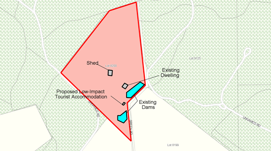
9.5.4 Proposed Low-Impact Tourist Accommodation at Lot 8327 (127) Gabbedy Road, Meerup
|
PROPONENT |
JM Bailey & BJ Thiele |
|
OWNER |
JM Bailey & BJ Thiele |
|
LOCATION / ADDRESS: |
Lot 8327 (127) Gabbedy Road, Meerup |
|
WARD: |
Coastal |
|
ZONE: |
Priority Agriculture |
|
DIRECTORATE: |
Development and Regulation |
|
FILE REFERENCE: |
DA17/175, P54223 |
|
LEGISLATION: |
Planning and Development Act 2005, Shire of Manjimup Local Planning Scheme No.4. |
|
AUTHOR: |
Jason Giadresco |
|
DATE OF REPORT: |
30/08/2017 |
|
DECLARATION OF INTEREST: |
Nil |
Background:
Council is requested to consider an application for Low Impact Tourist Accommodation (Short Stay) at Lot 8327 (379) Gabbedy Road, Meerup. Location, site and development plans of the proposal are attached.
ATTACHMENT: 9.5.4(1)
Location Plan
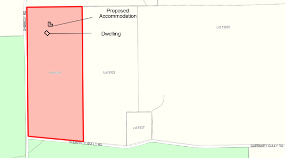
Lot 8327 is 39.44ha in area and is located at the end of the constructed section of Gabbedy Road via Double Bridges Road. The property contains a dwelling, shed and two small soak dams toward the southern end of the property. The property is largely covered in native vegetation.
The application proposes the partial conversion of the shed on the property into a two-storey 105m2, 2 bedroom, self-contained Low-Impact Tourist Accommodation. Two (2) car parking spaces are available for vehicles and a maximum of 4 persons are proposed to be accommodated at any one time.
Council is requested to determine the application as the proposal is for a discretionary use that may only be determined by Council.
PUBLIC Consultation Undertaken:
The application was advertised over 16 days, ensuring a minimum comment period of 14 days in accordance with clause 9.6 of the Scheme, and to allow for the letter to reach the recipients with adequate time to respond. One submission was provided by an adjoining landowner, which is discussed within the comment section below. The submission received is attached.
ATTACHMENT: 9.5.4(2)
Advice provided by the Department of Biodiversity, Conservation and Attractions (DBCA) provided no objection to the application.
COMMENT (Includes Options):
The provisions of the Shire of Manjimup Local Planning Scheme No 4 (the Scheme), include the subject land within the ‘General Agriculture’ Zone. Holiday Accommodation – Low Impact is an ‘A’ use within the General Agriculture Zone. That is a use which is not permitted unless approved by Council after advertising.
To assist Council in determining the application, the following comments are offered:
Proposal Details
The proposed Low-Impact Tourist Accommodation building will:
· accommodate a maximum of 4 persons at any one time;
· be supplied with water from the existing 100,000 on-site tank, treated to a potable standard;
· be served by 2 parking bays located directly next to the holiday accommodation; and
· be managed in accordance with the details in the Management Plan provided.
Clause 5.34.2.4 (4)(f) of the Scheme, states that within the General Agriculture zone Low-Impact Tourist Accommodation – Short Stay is limited to not more than 4 holiday accommodations or guest bedrooms to accommodate no more than 20 persons or equivalent accommodation types (including bed & breakfast facilities).
Assessment of the application confirms that the proposed accommodation meets the above definition of ‘low impact development’ on the basis that the proposed accommodation unit will be a maximum number of guests to 4 persons, compliant with the 20 person limit imposed by the Scheme.
Submission
The adjoining landowners at Lot 8326 Gabbedy Road have made a submission providing no objection to the proposal, but request that information (signage, brochures) identifying the property boundary between the two lots be provided by the proponents to guests to ensure the ongoing privacy of the landowners at Lot 8326.
In light of this, Shire officers recommend advice be included on any approval issued by Council requesting the proponents to clearly indicate where the boundaries of Lot 8327 are located through the Emergency Evacuation Plan, to ensure guests do not trespass onto adjoining properties.
Setbacks
The Scheme states that development within the General Agriculture zone shall conform to the following setbacks – 30 metres from front and rear and 10 metres from sides. The development is located within an existing building 150m from the front property boundary.
With regard to side and rear setbacks, the proposal site is located over 100m to side boundaries and 100m to the rear boundary and therefore deemed compliant with the Scheme’s setback requirements.
Road Access
Gabbedy Road is to be used as the main thoroughfare to access the proposed development. Generally, the condition and geometry of Gabbedy Road could be described as adequate. However, it is possible that the road geometry and condition will not suit the on-going development of a tourism business.
Given that approval to the proposal will only result in a low number of additional traffic movements, an upgrading of Gabbedy Road is not recommended. It is furthermore considered that a condition requiring the upgrading of Gabbedy Road, at the proponent’s cost, would make the proposal unviable.
Notwithstanding this, Shire officers request that it be recognised that the road is a Local Rural Road, provided in an ‘as-is’ condition and Council’s plans for Gabbedy Road will not be modified as a result of this private business. An advice note to this effect will be included on any approval granted by Council.
Emergency Management
The proponent has submitted a draft Emergency Plan detailing emergency information for guests. Shire officers recommend that this information should be incorporated into an Evacuation Plan depicting exit routes from the property and made available in the proposed new holiday accommodation in accordance with Council Policy.
Should Council wish to approve the application, it is recommended that an appropriate conditions be imposed to require this matter to be addressed.
Bushfire Attack Level Assessment
Given the location of the proposal is within a designated Bushfire Prone Area, the proponents have provided a Bushfire Attack Level (BAL) Assessment as required by State Planning Policy 3.7 Planning in Bushfire Prone Areas (SPP No 3.7). The BAL Assessment has determined a level of BAL-FZ.
As prescribed by SPP No 3.7 and the associated guidelines, development in bush fire prone areas shall not be approved unless it can be demonstrated that the development, once complete, will be subject to a maximum Bush Fire Attack Level of BAL 29. A Bushfire Management Plan should therefore be required prior to any development, demonstrating that this can be achieved.
A condition that the proposal be constructed in accordance with the assessment findings and Australian Standard 3959 is recommended to be included on any approval issued by Council.
Non-planning Requirements
The requirements for provision of water, effluent disposal and property bush fire protection will be conveyed as advice notes as these are requirements under other legislation.
Conclusion
The Scheme allows Council to approve low impact tourist accommodation – short stay proposals provided that any impact from any such land uses or development is contained on-site. The proposed development is considered to be appropriately located and is not expected to result in any significant impact on nearby intensive agricultural activities and adjoining properties.
Given the above, it is recommended that the application for planning consent be approved subject to conditions.
STATUTORY ENVIRONMENT:
Planning and Development Act 2005 and Shire of Manjimup Local Planning Scheme No. 4.
Policy / Strategic Implications:
Nil.
Organisational risk management:
Nil.
Financial Implications:
Nil.
Sustainability:
Environmental: Nil.
Economic: Nil.
Social: Nil. The concerns provided by the adjoining neighbour can be suitably addressed through the provision of advice to the proponent.
VOTING REQUIREMENTS: SIMPLE MAJORITY
Officer Recommendation:
That Council:
In accordance with Part 10 of Shire of Manjimup Local Planning Scheme No. 4 grants development approval for the Low Impact Tourist Accommodation (Short Stay) at Lot 8327 (127) Gabbedy Road, Meerup in accordance with the submitted plans as attached at Attachment 9.5.4(1) and subject to the following conditions:
a) Prior to commencement of the development hereby approved, the applicant shall prepare a Bush Fire Management Plan demonstrating how the Bush Fire Attack Level will be reduced and maintained so as to ensure that the development will be subject of to a maximum of BAL 29, to the satisfaction of the Shire of Manjimup;
b) The Holiday Accommodation hereby approved is limited to a maximum of four (4) persons in the premises at any one time to the satisfaction of the Shire of Manjimup;
c) The Holiday Accommodation is not to be occupied by a person for more than three (3) months within any twelve (12) month period. In this regard, the manager/operator is to maintain a register of guests and the duration of their occupation to the satisfaction of the local government, and the register shall be made available for perusal by Shire officers on demand;
d) The proposed Holiday Accommodation is to be constructed in accordance with the Bushfire Attack Level Assessment Report as submitted and the requirements of Australian Standard 3959;
e) The amended Emergency Evacuation Response Plan is to be updated to reflect the approved accommodation unit and displayed in the Holiday Accommodation at all times;
f) Prior to the occupation of the development for its approved purpose, a minimum of 2 car parking spaces shall be set aside for guests’ parking, shall be marked permanently as such, and shall be located so as to be easily accessible, to the satisfaction of the Shire of Manjimup;
g) An on-site potable water supply shall be provided on the site and connected to the development prior to occupation and shall thereafter be permanently maintained to the satisfaction of the Shire of Manjimup; and
h) The submitted management details which form part of the initial application shall be implemented on an ongoing basis to the satisfaction of the Shire of Manjimup.
Advice to Applicant:
a) The current level of construction of Gabbedy Road is provided in an “as is” considered appropriate to support the proposal and no upgrade of the road will take place to cater for increased traffic that may be generated by the development.
b) The approved development must comply with all relevant provisions of the Public Health Act 2016 and the Building Act 2014.
c) A Building Permit is required to be obtained from Building Services for the reclassification of the building to guest accommodation.
d) Firebreaks and low fuel zones are to be installed and maintained to the satisfaction of the local government around all boundaries and buildings on the subject property, in accordance with the requirements of the Annual Shire Firebreak Notice endorsed by the Shire of Manjimup.
e) The proponent is advised that any commercial use operated in accordance with the attached planning approval may result in the method of rating of the subject property or part thereof being reviewed. [The proponent is invited to liaise with the Rates Officer for further advice in respect to this].
f) The Emergency Evacuation Plan is to accurately depict the location of subject property’s boundaries, to prevent guests from entering adjoining land.
g) The proposed operation is required to comply with the ‘Environmental Protection (Noise) Regulations, 1997’.
|
Moved: Munro, G Seconded: Taylor, R
That Council: In accordance with Part 10 of Shire of Manjimup Local Planning Scheme No. 4 grants development approval for the Low Impact Tourist Accommodation (Short Stay) at Lot 8327 (127) Gabbedy Road, Meerup in accordance with the submitted plans as attached at Attachment 9.5.4(1) and subject to the following conditions: a) Prior to commencement of the development hereby approved, the applicant shall prepare a Bush Fire Management Plan demonstrating how the Bush Fire Attack Level will be reduced and maintained so as to ensure that the development will be subject of to a maximum of BAL 29, to the satisfaction of the Shire of Manjimup; b) The Holiday Accommodation hereby approved is limited to a maximum of four (4) persons in the premises at any one time to the satisfaction of the Shire of Manjimup; c) The Holiday Accommodation is not to be occupied by a person for more than three (3) months within any twelve (12) month period. In this regard, the manager/operator is to maintain a register of guests and the duration of their occupation to the satisfaction of the local government, and the register shall be made available for perusal by Shire officers on demand; d) The proposed Holiday Accommodation is to be constructed in accordance with the Bushfire Attack Level Assessment Report as submitted and the requirements of Australian Standard 3959; e) The amended Emergency Evacuation Response Plan is to be updated to reflect the approved accommodation unit and displayed in the Holiday Accommodation at all times; f) Prior to the occupation of the development for its approved purpose, a minimum of 2 car parking spaces shall be set aside for guests’ parking, shall be marked permanently as such, and shall be located so as to be easily accessible, to the satisfaction of the Shire of Manjimup; g) An on-site potable water supply shall be provided on the site and connected to the development prior to occupation and shall thereafter be permanently maintained to the satisfaction of the Shire of Manjimup; and h) The submitted management details which form part of the initial application shall be implemented on an ongoing basis to the satisfaction of the Shire of Manjimup. Advice to Applicant: a) The current level of construction of Gabbedy Road is provided in an “as is” considered appropriate to support the proposal and no upgrade of the road will take place to cater for increased traffic that may be generated by the development. b) The approved development must comply with all relevant provisions of the Public Health Act 2016 and the Building Act 2014. c) A Building Permit is required to be obtained from Building Services for the reclassification of the building to guest accommodation. d) Firebreaks and low fuel zones are to be installed and maintained to the satisfaction of the local government around all boundaries and buildings on the subject property, in accordance with the requirements of the Annual Shire Firebreak Notice endorsed by the Shire of Manjimup. e) The proponent is advised that any commercial use operated in accordance with the attached planning approval may result in the method of rating of the subject property or part thereof being reviewed. [The proponent is invited to liaise with the Rates Officer for further advice in respect to this]. f) The Emergency Evacuation Plan is to accurately depict the location of subject property’s boundaries, to prevent guests from entering adjoining land. g) The proposed operation is required to comply with the ‘Environmental Protection (Noise) Regulations, 1997’.
CARRIED: 8/0 |
53
9.5.5 Proposed Small Bar, Holiday Accommodation and Cafe at Lot 106 (23) Brockman Street, Pemberton
|
PROPONENT |
Jarrah Forest Consulting Pty Ltd |
|
OWNER |
Jarrah Forest Consulting Pty Ltd |
|
LOCATION / ADDRESS: |
Lot 106 (23) Brockman Street, Pemberton |
|
WARD: |
West |
|
ZONE: |
Town Centre Zone |
|
DIRECTORATE: |
Development and Regulation |
|
FILE REFERENCE: |
DA17/130, P57600 |
|
LEGISLATION: |
Planning and Development Act 2005, Shire of Manjimup Local Planning Scheme No.4 |
|
AUTHOR: |
Jason Giadresco |
|
DATE OF REPORT: |
30/08/2017 |
|
DECLARATION OF INTEREST: |
Nil |
Background:
Council is requested to consider a development application for the construction of a Small Bar, Holiday Accommodation and Café at Lot 106 (23) Brockman Street, Pemberton. Location, Site and Development Plans are attached.
ATTACHMENT: 9.5.5(1)
Location Plan
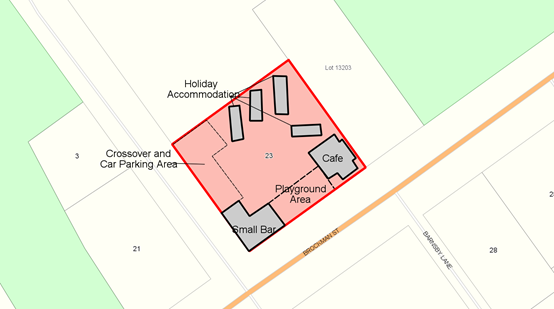
Lot 106 is 1484m² and contains a Shop located on the corner of Brockman Street and Railway Crescent. The balance of the property is largely vacant, with a large, well-developed tree located in the centre of the property.
The application proposes the following development on the property:
· A Small Bar and deck, to be located on the site of the existing Shop, which will undergo significant extension and renovation. The development will accommodate 36 patrons;
· A Café to accommodate 8 patrons. The Café will primarily be operated on a “take-away” basis, hence the small seating number;
· 4 Holiday Accommodation Units, accommodating 2 persons in each unit;
· Construction of 9 car parking bays and crossover, including 1 disability bay on the property adjacent to Railway Crescent; and
· A ‘Nature Play’ playground located between the Café and Small Bar for the use of patrons’ children, and the children within the wider Pemberton community.
The materials to be used in the construction of the Small Bar, Café and Holiday Accommodation Units are to be sympathetic to the predominant ‘mill town’ aesthetic in Pemberton, using Timber cladding with a metal roof.
Council is requested to determine the application. In order to facilitate the proposed use, Council is requested to consider varying the standard parking requirements that would otherwise apply to the land uses.
PUBLIC Consultation Undertaken:
The application was advertised for a 14 day period in accordance with clause 9.6 of the Scheme. Five (5) submissions were received, 4 being from adjoining landowners, and 1 from Main Roads Western Australia. A Schedule of Submissions details the content of each is attached.
ATTACHMENT: 9.5.5(2)
COMMENT (Includes Options):
The provisions of Local Planning Scheme No 4 (LPS No 4) include the subject land within the Town Centre Zone. Having regard to the activities that would be undertaken on the land, is best classified as a “small bar”, “café” and “holiday accommodation” which LPS No 4 defines as follows:
“café” means premises similar to those of a restaurant but from which only snacks and light refreshments are served during normal working hours and the term includes premises referred to as café;
A café is a “P” use within the Town Centre Zone. That is a use which “is permitted by the Scheme provided that the use complies with the relevant development standards and requirements of the Scheme.”
In regards to development standards and requirements, the following is a summary of the normal requirements that would apply to a café within the Town Centre Zone:
· Provision of off street parking at a rate not less than 1 bay per 4 persons;
· The car parking referred to above being constructed with a sealed surface with formal drainage and line marking;
· A minimum of 5% landscaping.
“small bar” means premises licensed as a small bar under the Liquor Control Act and used to sell liquor for consumption on the premises, but not including the sale of packaged liquor; and with the number of persons who may be on the licensed premises limited to a maximum of 120;
“holiday accommodation” means land and buildings providing facilities for tourist and travellers, including chalets, cabins, farm stay, bed and breakfast, camping grounds, caravan parks and motels, none of which is occupied by the tenant for a period of more than three months in any one calendar year.
A small bar and holiday accommodation are a “D” land use within the Town Centre Zone. That is a use that “means that the use is not permitted unless the local government has exercised its discretion by granting planning approval”
In regards to development standards and requirements, the following is a summary of the normal requirements that would apply to a small bar and holiday accommodation within the Town Centre Zone:
· Provision of off street parking at a rate not less than 1 bay per 4 persons for a small bar;
· Provision of off street parking at a rate of not less than 1 bay per holiday accommodation unit;
· The car parking referred to above being constructed with a sealed surface with formal drainage and line marking;
· A minimum of 5% landscaping.
The application has been assessed against Clauses 4.2 and 5.32, and Clause 3.5 of Schedule 8 of the Scheme. The application meets Zone and Precinct requirements. The proposed development contains adequate landscaping as depicted on the attached plans and is considered compliant. The other aspects as outlined above, as well as submissions from adjoining neighbours and Main Roads Western Australia, will be discussed through the remainder of the report.
To assist Council in determining this matter, the following comments are provided:
Variation of Development Standards
The ability for Council to reduce the required number of car parking bays is reflected within two clauses of LPS No 4. Firstly as outlined under clause 5.5.1, except in respect of the Residential Design Codes, if an application for planning approval does not comply with a standard or requirement prescribed by the Scheme, “the local government may, despite the non-compliance, approve the application unconditionally, or subject to such conditions as the local government thinks fit”.
Car Parking and Access
Parking requirements have been calculated in accordance with Table 2 of clause 5.17 of the Scheme, confirming a minimum of 16 bays are required to service the development. The proponents have indicated that 9 bays will be constructed to a sealed standard on site to Scheme requirements, inclusive of one disability bay. Four (4) bays will exclusively service the holiday accommodation on site, with the balance to service the Small Bar.
A number of the submissions received raise issues related to carparking. Discussions with the proponents have resulted in the revision of the car parking on site, increasing the number of proposed bays from 6 to 9. Shire officers have determined that 4 car parking bays are available in Railway Crescent, and 5 bays are available in Brockman Street immediately adjacent to the property. Combining off-street and on-street parking, 18 bays would be available to service the proposed development.
Council is therefore being asked to consider granting a dispensation in the form of a reduction of the required onsite parking, permitting the use of the 9 car-parking bays along Brockman Street and Railway Crescent, to meet the car-parking requirements of the proposed development under the scheme.
In accordance with Clause 5.5 Council may approve a development with a reduced number of car parking bays, provided that it is satisfied that:
(i) Approval of the proposed development would be appropriate having regard to the criteria set out in clause 10.2; and
(ii) The non-compliance with not have an adverse effect upon the occupiers or users of the development, the inhabitants of the locality or the likely future development of the locality.
Shire officers understand that the Small Bar will be operating in the late afternoon to evening, whilst the peak period of the Café will largely be operating during daylight hours. Parking for the Holiday Accommodation will be marked by designated bays on the subject site. It is anticipated that most car parking bays will be required during the evening, at a time when Railway Crescent and Brockman Street will be underutilised.
Staff contend that the proposed arrangement for the provision of car parking for the land uses to be developed that being, 9 car parking bays on the subject site access from Railway Crescent and 9 car-parking bays on Brockman Street are sufficient to meet the objectives for Car Parking contained in Clause 5.17 of the Scheme.
Liquor Licencing Requirements
A number of submissions raised concern about the potential for intoxicated patrons leaving the Small Bar and disturbing the amenity of the area. Although this is not a matter of Council’s consideration, it is expected of the proponents that service of alcohol will be undertaken in accordance with the requisite legislation ensuring the responsible service of alcoholic beverages. Furthermore, disturbance of the peace by patrons of the Small Bar is a matter for the Police.
A Small Bar is permitted to open between 6am and 12 midnight on any day other than Sunday, and from 10am to 10pm on a Sunday. The hours of operation have not been determined by the proponent at this time. Nevertheless, it is recommended a condition ensuring compliance with the requirements of the Department of Racing, Gaming and Liquor Small Bar Licence be included on any approval issued by Council.
Holiday Accommodation Requirements
Although plans have been provided on the design of the accommodation, no Management Plan or Emergency Evacuation Plan has been provided as to the ongoing management of the facility. To this end, conditions requiring that both these plans be produced, submitted and approved by the Shire prior to occupation of the building will be included on any approval issued.
Additionally, a condition will be included to manage the length of time any one person may spend at the accommodation. No person may spend longer than 3 months in any 12 month period at the accommodation. A condition reflecting this will be included on approval.
Drainage Requirements
It is unclear as to whether the drainage is to be contained on site or to be connected to the local drainage system. Given the large amount of hard surface areas on the proposal site, it is considered that the development will need to connect to the local drainage system. A condition reflecting this will be included on approval. It is also requested that the applicant be advised that an upgrading of the existing infrastructure may be required.
Rubbish Areas
Rubbish storage areas are to be provided at the rear of the Café and Small Bar. A condition that these rubbish areas are screened and constructed on a hard stand area will be included on approval.
Lighting
Given the hours of the development’s operation, it is likely that lighting of external areas will be required and that the impact of any lighting will need to be managed to prevent it disrupting the amenity of the area, particularly those properties with residences located adjacent to the subject site. Therefore, Shire officers recommend that the external lighting be installed as to not have a detrimental impact on the amenity of the area. A condition reflecting this is recommended to be included on any approval issued by Council.
Landscaping
The Scheme requires that a minimum 5% of the site be landscaped. The application details that a level of landscaping exceeding, inclusive of the playground, exceeds the Scheme requirements. A standard condition is recommended to ensure that the proposed landscaping is completed.
Sewerage Connection
Sewerage connection is available to the site adjacent to Railway Crescent. A condition requesting the connection of sewerage to the development should be included on any approval granted.
Environmental Health Requirements
The development will be required to register as a food business with the Shire. The Holiday Accommodation component will also require a Lodging House Permit to be obtained from the Shire prior to commencement of the use.
The Small Bar will also be required to apply to the local government to attain approvals under Section 39 and 40 of the Liquor Licensing Act 1988 for a permit to allow the legitimate sale of alcohol. This information should be communicated as advice to the applicant on any approval that may be issued.
Building Requirements
The Small Bar is to be established within an existing shop on the property. The refurbishment of the shop to accommodate the Small Bar within the existing building constitutes building work under provisions of the Building Regulations. As such, the refurbished building will have to comply with the Building Code of Australia 2012.
Additionally there are specific requirements prescribed by the Building Code relating to the provision of disabled access, toilets, fire safety measures etc, these requirements will be addressed during the assessment of the building application.
Conclusion
Given the applications conditional compliance, and the ability for car parking to be adequately managed within and around the site, the application is recommended for conditional approval by Council.
STATUTORY ENVIRONMENT:
Planning and Development Act 2005, Shire of Manjimup Local Planning Scheme No.4
Policy / Strategic Implications:
The proposal is considered to be consistent with Community Goals 2.1, 2.3 and 2.6 as outlined in Council’s adopted Strategic Community Plan 2017 -2027, being as follows:
2.1 - New people and new businesses are attracted to the region.
2.3 - The local economy is diversified and supports a range of industries and job opportunities.
2.6 - The region grows in reputation as a world-class culinary, agricultural, environmental and trails tourism destination.
Organisational risk management:
Nil.
Financial Implications:
Nil.
Sustainability:
Environmental: Nil.
Economic: Approval to the application will result in three new businesses being located in Pemberton adding to the range of economic activity and resulting in the creation of additional employment.
Social: The concerns of adjoining neighbours are considered to be suitably addressed by the conditions and advice provided in this report to protect the amenity of the area in light of the proposed development.
VOTING REQUIREMENTS: SIMPLE MAJORITY
Officer Recommendation:
That Council:
1. In accordance with clause 5.5.1 and Part 10 of Shire of Manjimup Local Planning Scheme No.4 varies the parking requirements specified by the Scheme and grants planning approval to the change of use and development of a Small Bar, Holiday Accommodation and Café/Restaurant on Lot 106 Brockman Street, Pemberton in accordance with the submitted plans and subject to the following conditions:
a) The development hereby approved must be carried out generally in accordance with the plans and specifications submitted with the application and these shall not be altered and/or modified without the prior knowledge and written consent from the Shire of Manjimup;
b) Before the development is occupied, the property must be connected to the Water Corporation reticulated sewerage system;
c) The area set aside for the parking of vehicles, together with the associated access lanes as delineated on the endorsed plan shall:
· Be constructed, drained and marked to the satisfaction of the Council prior to the commencement of the use hereby permitted.
· Thereafter be maintained to the satisfaction of the Council.
· Be made available for such use at all times and not used for any other purpose.
d) Four (4) of the car parking bays to be provided on site are to be marked and maintained for the exclusive use of the Holiday Accommodation only to the satisfaction of the Shire of Manjimup.
e) A minimum of 1 accessibility car bay shall be maintained on site at all times in accordance with the Australian Standard 2890.1 –2009, and connected to a continuous accessible path to the main entrance of the building or facility. The design and signage of the bay(s) and path(s) are to be in accordance with the Australian Standard 1428.1 – 2009;
f) The vehicular crossover between the subject land and Railway Crescent is to be located, designed, constructed, sealed and drained to the satisfaction of the Shire of Manjimup prior to occupation of the premises;
g) The rubbish storage area as shown on the approved plan is to be constructed with walls of not less than 1.5 metres in height of brick/Colorbond construction or other material to the satisfaction of the Shire of Manjimup’s Principal Environmental Health Officer;
h) Any external lighting proposed on the subject property must be installed as to not have a detrimental impact upon traffic in the vicinity or upon the general amenity of neighbouring properties to the satisfaction of the Shire of Manjimup;
i) The Holiday Accommodation units are not to be occupied by a person for more than three (3) months within any twelve (12) month period. In this regard, the manager/operator is to maintain a register of guests and the duration of their occupation to the satisfaction of the Shire of Manjimup, and the register shall be made available for perusal by the Shire of Manjimup on demand;
j) Prior to the commencement of the approved use, the applicant is to supply a copy of their Public Liability Insurance to the Shire of Manjimup;
k) A Management Plan for the Holiday Accommodation, Small Bar and Café is to be developed, submitted and approved by the Shire of Manjimup prior to occupation of the premises;
l) An Emergency Evacuation Plan for the Holiday Accommodation is to be developed, submitted and approved by the Shire of Manjimup prior to occupation of the premises;
m) The consumption of alcohol by patrons of the Small Bar is prohibited within the Shire Road Reserve.
n) All proposed/approved landscaping works are to be completely installed prior to the occupation or use of any land or building for the purposes permitted by this planning approval. In certain circumstances (such as those brought about by adverse seasonal conditions, for example) such works (or their final completion) may be allowed to be deferred for up to a maximum six (6) months subject to the arrangements forming the subject of a prior application to and approval by local government in writing.
o) All stormwater and drainage runoff is to be retained on the subject property or be provided with stormwater drainage connections to the comprehensive district drainage system in the area at the developers cost to the satisfaction to the Shire of Manjimup.
2. Advises the Proponent:
a) The proponent is advised that this planning approval is NOT a building permit. A certified building permit must be formally applied for and obtained BEFORE the commencement of any site and/or development works;
b) The approved development is to comply with the requirements of the “Health (Treatment of Sewage and Disposal of Effluent and Liquid Waste) Regulations, 1974”;
c) The premises and equipment the subject of this planning approval is required to comply with clause 3.2.3 of the Australian Food Safety Standards.
d) Regardless of whether a building permit is required, application shall be made to the Shire of Manjimup’s Environmental Health Team for assessment and approval prior to commencing development.
e) Two (2) sets of scaled plans (minimum 1:100) and specifications detailing the design and fit out shall be submitted to Environmental Health Section and shall include the following information:
· the use of each room/area;
· the structural finishes of walls, floors, ceilings, benches, shelves and other surfaces;
· the position and type of all fixtures, fittings and equipment;
· all sanitary conveniences, floor wastes/bucket traps/cleaner’s sinks, grease traps, etc.;
· waste storage and disposal areas;
· plans and specifications of the mechanical exhaust system if cooking is to take place in the food business;
· specifications of all cooking equipment (stoves, ovens, fryers, etc.);
· elevations of food handling and storage areas; and
· details of the types of food being prepared or sold.
Please refer to the Shire of Manjimup’s Requirements for the Establishment, Construction and Fit Out of Food Premises available on the website at www.manjimup.wa.gov.au.
A final inspection of the premises will be required to be carried out by the Principal Environmental Health Officer prior to Registration / Notification under the Food Act 2008 and is a requirement prior to commencing operation.
Further information may be obtained from the Shire of Manjimup’s Environmental Health team on (08) 9771 7777;
d) If public consumption of alcohol is likely to occur on the subject premises, additional requirements may be imposed by the Liquor Licensing Division of the Department of Racing, Gaming and Liquor. It is recommended that the proponent consult with the Liquor Licensing Division, either directly (on 1800 634 541) or via the website: www.rgl.wa.gov.au for further information;
e) The Certificate of a Local Health Authority (Section 39) and Local Planning Authority (Section 40), required to support the application for a liquor license referred to in advice note (d) above, may be supplied by the Shire on receipt of a written request. An administration fee will be charged for each certificate, in accordance with adopted local government ‘Fees and Charges’ Schedules; and
f) The proposed operation is required to comply with the ‘Environmental Protection (Noise) Regulations, 1997’.
|
Moved: DeCampo, W Seconded: Winfield, C
That Council: 1. In accordance with clause 5.5.1 and Part 10 of Shire of Manjimup Local Planning Scheme No.4 varies the parking requirements specified by the Scheme and grants planning approval to the change of use and development of a Small Bar, Holiday Accommodation and Café/Restaurant on Lot 106 Brockman Street, Pemberton in accordance with the submitted plans and subject to the following conditions: a) The development hereby approved must be carried out generally in accordance with the plans and specifications submitted with the application and these shall not be altered and/or modified without the prior knowledge and written consent from the Shire of Manjimup; b) Before the development is occupied, the property must be connected to the Water Corporation reticulated sewerage system; c) The area set aside for the parking of vehicles, together with the associated access lanes as delineated on the endorsed plan shall: · Be constructed, drained and marked to the satisfaction of the Council prior to the commencement of the use hereby permitted. · Thereafter be maintained to the satisfaction of the Council. · Be made available for such use at all times and not used for any other purpose. d) Four (4) of the car parking bays to be provided on site are to be marked and maintained for the exclusive use of the Holiday Accommodation only to the satisfaction of the Shire of Manjimup. e) A minimum of 1 accessibility car bay shall be maintained on site at all times in accordance with the Australian Standard 2890.1 –2009, and connected to a continuous accessible path to the main entrance of the building or facility. The design and signage of the bay(s) and path(s) are to be in accordance with the Australian Standard 1428.1 – 2009; f) The vehicular crossover between the subject land and Railway Crescent is to be located, designed, constructed, sealed and drained to the satisfaction of the Shire of Manjimup prior to occupation of the premises; g) The rubbish storage area as shown on the approved plan is to be constructed with walls of not less than 1.5 metres in height of brick/Colorbond construction or other material to the satisfaction of the Shire of Manjimup’s Principal Environmental Health Officer; h) Any external lighting proposed on the subject property must be installed as to not have a detrimental impact upon traffic in the vicinity or upon the general amenity of neighbouring properties to the satisfaction of the Shire of Manjimup; i) The Holiday Accommodation units are not to be occupied by a person for more than three (3) months within any twelve (12) month period. In this regard, the manager/operator is to maintain a register of guests and the duration of their occupation to the satisfaction of the Shire of Manjimup, and the register shall be made available for perusal by the Shire of Manjimup on demand; j) Prior to the commencement of the approved use, the applicant is to supply a copy of their Public Liability Insurance to the Shire of Manjimup; k) A Management Plan for the Holiday Accommodation, Small Bar and Café is to be developed, submitted and approved by the Shire of Manjimup prior to occupation of the premises; l) An Emergency Evacuation Plan for the Holiday Accommodation is to be developed, submitted and approved by the Shire of Manjimup prior to occupation of the premises; m) The consumption of alcohol by patrons of the Small Bar is prohibited within the Shire Road Reserve. n) All proposed/approved landscaping works are to be completely installed prior to the occupation or use of any land or building for the purposes permitted by this planning approval. In certain circumstances (such as those brought about by adverse seasonal conditions, for example) such works (or their final completion) may be allowed to be deferred for up to a maximum six (6) months subject to the arrangements forming the subject of a prior application to and approval by local government in writing. o) All stormwater and drainage runoff is to be retained on the subject property or be provided with stormwater drainage connections to the comprehensive district drainage system in the area at the developers cost to the satisfaction to the Shire of Manjimup. 2. Advises the Proponent: a) The proponent is advised that this planning approval is NOT a building permit. A certified building permit must be formally applied for and obtained BEFORE the commencement of any site and/or development works; b) The approved development is to comply with the requirements of the “Health (Treatment of Sewage and Disposal of Effluent and Liquid Waste) Regulations, 1974”; c) The premises and equipment the subject of this planning approval is required to comply with clause 3.2.3 of the Australian Food Safety Standards. d) Regardless of whether a building permit is required, application shall be made to the Shire of Manjimup’s Environmental Health Team for assessment and approval prior to commencing development. e) Two (2) sets of scaled plans (minimum 1:100) and specifications detailing the design and fit out shall be submitted to Environmental Health Section and shall include the following information: · the use of each room/area; · the structural finishes of walls, floors, ceilings, benches, shelves and other surfaces; · the position and type of all fixtures, fittings and equipment; · all sanitary conveniences, floor wastes/bucket traps/cleaner’s sinks, grease traps, etc.; · waste storage and disposal areas; · plans and specifications of the mechanical exhaust system if cooking is to take place in the food business; · specifications of all cooking equipment (stoves, ovens, fryers, etc.); · elevations of food handling and storage areas; and · details of the types of food being prepared or sold.
Please refer to the Shire of Manjimup’s Requirements for the Establishment, Construction and Fit Out of Food Premises available on the website at www.manjimup.wa.gov.au.
A final inspection of the premises will be required to be carried out by the Principal Environmental Health Officer prior to Registration / Notification under the Food Act 2008 and is a requirement prior to commencing operation.
Further information may be obtained from the Shire of Manjimup’s Environmental Health team on (08) 9771 7777; d) If public consumption of alcohol is likely to occur on the subject premises, additional requirements may be imposed by the Liquor Licensing Division of the Department of Racing, Gaming and Liquor. It is recommended that the proponent consult with the Liquor Licensing Division, either directly (on 1800 634 541) or via the website: www.rgl.wa.gov.au for further information; e) The Certificate of a Local Health Authority (Section 39) and Local Planning Authority (Section 40), required to support the application for a liquor license referred to in advice note (d) above, may be supplied by the Shire on receipt of a written request. An administration fee will be charged for each certificate, in accordance with adopted local government ‘Fees and Charges’ Schedules; and f) The proposed operation is required to comply with the ‘Environmental Protection (Noise) Regulations, 1997’.
MOTION carried 7/1
|
66
9.5.6 Proposed Additional Accommodation Unit and Two Shipping Containers - Lot 1 (27685) South Western Highway, Balbarrup
|
PROPONENT |
R Fittock |
|
OWNER |
Statewide Resources Pty Ltd |
|
LOCATION / ADDRESS: |
Lot 1 (27685) South Western Highway, Balbarrup |
|
WARD: |
North Ward |
|
ZONE: |
Tourist Enterprise |
|
DIRECTORATE: |
Development & Regulation |
|
FILE REFERENCE: |
D17/138 |
|
LEGISLATION: |
Planning & Development Act 2005 |
|
AUTHOR: |
Brian Robinson |
|
DATE OF REPORT: |
31/08/2017 |
|
DECLARATION OF INTEREST: |
Nil |
Background:
The subject land is a 2.0209ha property located on the eastern side of the South Western Highway, bordering the northern boundary of Case Street in the locality of Balbarrup. The property is developed with the Gateway Motel consisting of a licensed premises, a managers residence and motel style accommodation.
A location plan is shown below.
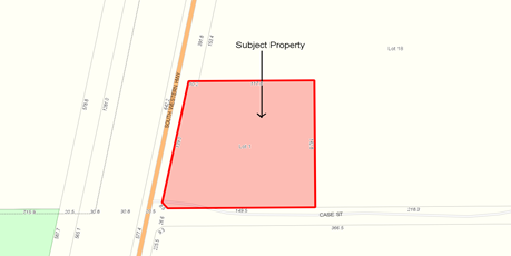
The applicant is seeking approval to the location of a transportable accommodation unit and two 6 metre long shipping containers at the rear of the existing development. Plans submitted in support of the application detail that the accommodation unit will be used as a single bedroom unit, with TV room/study, kitchen/living, bathroom and separate toilet. If approved the unit will be located within the area of the rear carpark. Copies of the submitted plans are shown attached.
ATTACHMENT: 9.5.6(1)
Council is requested to consider the proposal given that Shire Officers do not have the delegated authority to determine the application.
PUBLIC Consultation Undertaken:
The application was referred to the Department of Health for comment in respect of the disposal of effluent. A submission received from the Health Department is detailed within the comment section below, whilst a copy of the advice received is shown attached.
ATTACHMENT: 9.5.6(2)
COMMENT (Includes Options):
The provisions of Local Planning Scheme No 4 (LPS No 4) include the subject land within the Tourist Enterprise Zone. As outlined within clause 4.11.2 of LPS No 2, the objectives for the Tourist Enterprise include, but a not limited to:
(i) Encourage the development of the zone as one of the focal points for tourist/visitor related activities within the identified area or town while not compromising the visual and landscape qualities of the area;
(iv) encourage a range of recreational activities and accommodation styles within the Tourist Enterprise Zone in an form, style and density which is compatible with the surrounding land use and can be adequately serviced and complements the natural and built features of the locality;
To assist Council in determining the application, the following comments are offered:
Land Use
The proposed transportable represents an additional motel accommodation unit, consistent with the existing land use. The two shipping containers are proposed to be used for storage purposes associated with operation of the motel.
A “Motel” is a “D” use within the Tourist Enterprise Zone. That is a use which is not permitted unless the local government has exercised its discretion by granting planning approval.
Setbacks
Being located at the rear of the main motel building, the proposal complies with all setback requirements.
Carparking
The provisions of LPS No 4 identify that carparking is normally required at a rate of 1 carbay per accommodation unit and 1 carbay per 25m² of service area. Whilst the plans submitted do not detail the provision of additional carbays as part of this proposal, it is considered that there is more than sufficient carpark area to accommodate the required parking.
To ensure that parking in the area of the proposed development occurs in an orderly manner, it is recommended that a condition be imposed requiring the submission of a detailed parking plan and line marking on site, prior to the commencement of the use. The imposition of such a condition is consistent with the provisions of Part 10.8 of LPS No 4.
Landscaping
No additional landscaping is proposed in association with the current application. In accordance with clause 5.13.3 of LPS No 4, the level of landscaping provided in a Tourist Enterprise Zone will be determined by Council on the merits of the case.
Although the level of landscaping on site appears to be acceptable, it is recommended that the applicant be encouraged to establish additional landscaping in the area of the proposed transportable to provide shade and visual relief.
Effluent Disposal
As the proposal relates to a commercial development, the arrangements for effluent disposal must be approved by the Department of Health. Correspondence received from the Department of Health advises that they have no objection subject to existing wastewater system being upgraded to cater for the maximum occupancy of the development. An appropriate advice note is recommended should Council grant approval to the application.
STATUTORY ENVIRONMENT:
Local Planning Scheme No 4.
Policy / Strategic Implications:
Approval to the application as submitted will increase the storage and accommodation capacity associated with the existing Motel. The application is therefore consistent with Shire of Manjimups Community Strategic Plan, with particular reference to Strategy B12, being to provide “development opportunities and support local businesses to thrive”.
Organisational risk management:
Nil
Financial Implications:
Nil
Sustainability:
Environmental: Nil
Economic: Approval to the application will increase the number of holiday accommodation units available within the vicinity of the Manjimup Townsite.
Social: Nil
VOTING REQUIREMENTS: SIMPLE MAJORITY
Officer Recommendation:
That Council, in accordance with Part 10 of Local Planning Scheme No 4 grants development approval to the proposed transportable holiday accommodation unit and two shipping containers, being for onsite storage associated with the motel on Lot 1 (27685) South Western Highway, Balbarrup subject to compliance with the following conditions:
1. The development hereby approved is to be carried out generally in accordance with the plans and specifications submitted with the application and these shall not be altered and/or modified without the prior knowledge and written consent of the Shire of Manjimup.
2. Prior to commencement of the use of the accommodation unit hereby approved, the development shall be connected to a waste water disposal system acceptable to the Shire of Manjimup and/or the Department of Health.
3. Prior to commencement of the use of the accommodation unit hereby approved, the applicant shall prepare a detailed plan for the adjacent car parking area setting out parking bays in accordance with the requirements of Local Planning Scheme No 4. Parking bays shown on the plan shall be line marked and from thereon maintained to the satisfaction of the Shire of Manjimup.
4. All stormwater and drainage runoff is to be retained on the subject property or be provided with stormwater drainage connections to the comprehensive district drainage system in the area at the developers cost to the satisfaction to the Shire of Manjimup.
5. This approval shall expire if the development hereby permitted is not completed within two years of the date hereof, or within any extension of that time which, upon written application (made before or within 21 days after the expiry of the approval) to Shire of Manjimup, is granted by it in writing.
Advice to Applicant:
1. Further to condition No 2 above, as reflected within advice received from the Department of Health, the Department requires the existing wastewater system to be upgraded to cater for the maximum occupancy of the development.
2. Further to condition No 3 above, the applicant is advised that the provisions of Local Planning Scheme No 4 stipulate that parking bays shall be not less than 2.6m wide by 5.5 metres deep with 6 metre access way.
3. Whilst the application hereby approved does not warrant a formal requirement for additional landscaping within the site, the applicant is encouraged to consider the establishment of additional landscaping in the area of the transportable holiday accommodation unit hereby approved in order to provide shade and visual relief from the adjacent car parking area.
|
Moved: Bavich, D Seconded: Tapley, D
That Council, in accordance with Part 10 of Local Planning Scheme No 4 grants development approval to the proposed transportable holiday accommodation unit and two shipping containers, being for onsite storage associated with the motel on Lot 1 (27685) South Western Highway, Balbarrup subject to compliance with the following conditions: 1. The development hereby approved is to be carried out generally in accordance with the plans and specifications submitted with the application and these shall not be altered and/or modified without the prior knowledge and written consent of the Shire of Manjimup. 2. Prior to commencement of the use of the accommodation unit hereby approved, the development shall be connected to a waste water disposal system acceptable to the Shire of Manjimup and/or the Department of Health. 3. Prior to commencement of the use of the accommodation unit hereby approved, the applicant shall prepare a detailed plan for the adjacent car parking area setting out parking bays in accordance with the requirements of Local Planning Scheme No 4. Parking bays shown on the plan shall be line marked and from thereon maintained to the satisfaction of the Shire of Manjimup. 4. All stormwater and drainage runoff is to be retained on the subject property or be provided with stormwater drainage connections to the comprehensive district drainage system in the area at the developers cost to the satisfaction to the Shire of Manjimup. 5. This approval shall expire if the development hereby permitted is not completed within two years of the date hereof, or within any extension of that time which, upon written application (made before or within 21 days after the expiry of the approval) to Shire of Manjimup, is granted by it in writing. Advice to Applicant: 1. Further to condition No 2 above, as reflected within advice received from the Department of Health, the Department requires the existing wastewater system to be upgraded to cater for the maximum occupancy of the development. 2. Further to condition No 3 above, the applicant is advised that the provisions of Local Planning Scheme No 4 stipulate that parking bays shall be not less than 2.6m wide by 5.5 metres deep with 6 metre access way. 3. Whilst the application hereby approved does not warrant a formal requirement for additional landscaping within the site, the applicant is encouraged to consider the establishment of additional landscaping in the area of the transportable holiday accommodation unit hereby approved in order to provide shade and visual relief from the adjacent car parking area. CARRIED: 8/0 |
72
9.5.7 Proposed Local Scheme Amendment No 21 - Boronia Ridge Estate, Walpole
|
PROPONENT |
Sam Williams, Consultant |
|
OWNER |
Sunland Pty Ltd |
|
LOCATION / ADDRESS: |
Lots 303 and 655 Karri Street, Walpole |
|
WARD: |
South Ward |
|
ZONE: |
Residential |
|
DIRECTORATE: |
Development & Regulation |
|
FILE REFERENCE: |
F160271 |
|
LEGISLATION: |
Planning and Development Act 2005. |
|
AUTHOR: |
Brian Robinson |
|
DATE OF REPORT: |
1/09/2017 |
|
DECLARATION OF INTEREST: |
Nil |
Background:
The Boronia Ridge Estate is a residential estate approximately 500m west of the Walpole, falling within the Walpole town site boundary. The Estate is bordered by the Walpole Inlet and the Walpole River.
Whilst the majority of the estate has been developed, Lots 303 and 655, comprising a total area of approximately 19.614ha are yet to be subdivided. A location plan shown Lots 303 and 655 is shown below, whilst a copy of the approved Subdivision Guide Plan is shown attached.
ATTACHMENT: 9.5.7(1)
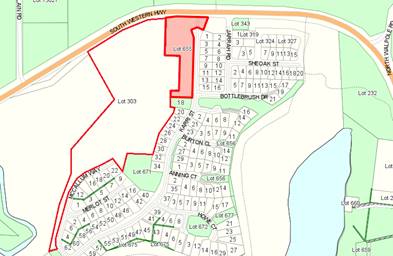
At its Ordinary Meeting held on 20 August 2015, Council resolved to initiate a scheme amendment to increase the residential density on the subject land from R10 to R15. Subsequently on 7 July 2016, Council resolved to adopt the amendment for the purposes of advertising. Relevant excerpts from the Scheme Amendment Document are shown attached, including a copy of the draft Subdivision Concept Plan.
ATTACHMENT: 9.5.7 (2)
Council’s July 2016 resolution, classified the amendment as a standard amendment in accordance with clause 35(2) of the Planning and Development (Local Planning Scheme) Regulations. Council’s resolution also provided the applicant with an:
“opportunity to revise the environmental documentation prepared in support of the amendment to address potential environmental impacts associated with the wholesale clearing of vegetation and the potential presence of Acid Sulphate Soils prior to endorsement of the amendment documentation for the purposes of advertising.”
With advertising of the amendment now complete, Council is requested to consider adopting the amendment for final approval having regard to the submissions received.
PUBLIC Consultation Undertaken:
The application has been referred to the Environmental Protection Authority for assessment in accordance with the Planning & Development Act 2005 and has subsequently been advertised for a period of 42 days.
Advertising consisted of two signs being erected on the site, advertisements within newspapers circulating within the district and the Western Australian newspaper. Correspondence was also forwarded to relevant government agencies.
Advertising closed on the 2 August 2017 with a total of 10 submissions received. A summary of the submissions received is shown attached, whilst their content is discussed within the comment section of this agenda item.
ATTACHMENT: 9.5.7(3)
COMMENT (Includes Options):
The provisions of Local Planning Scheme No 4 (LPS No 4) include the Boronia Ridge Estate within the Residential Zone. LPS No 4 identifies that the maximum permitted density is current R10, which equates to a minimum lot size of 875m² with a requirement that an average lot size of 1,000m² is maintained.
Should the proposed Scheme Amendment be approved, the minimum lot size would be reduced to 580m² with an average of 666m² being required. As reflected within the proposed Subdivision Concept Plan, this would permit the lot yield for the balance of the estate to increase from 30 to 44 lots.
To assist Council in determining whether to adopt the amendment for final approval, the following comments are offered:
Walpole Planning Precinct
In addition to including the land within the Residential Zone, the provisions of LPS No 4 include the land comprising the Boronia Ridge Estate within a “Planning Precinct”, being Walpole Planning Precinct No 1 under Schedule 8 the Scheme. As detailed in schedule 8, the purpose of a planning precinct outlines the local government’s objectives for the area. All development within a planning precinct requires prior planning consent.
With specific reference to Walpole Planning Precinct 1, the provisions of Schedule 8 specifies, amongst other things:
· Subdivision may only occur in accordance with an endorsed Structure Plan;
· The use of non-reflective building materials is required;
· Fencing shall not interfere with surface water flows;
· The minimum standard of fencing is post and wire fencing;
· Except for the construction of a residence, associated structures or bushfire prevention measures, vegetation must be retained on site; and
· No cats are permitted within the estate.
The above provisions will apply to the subject land irrespective of the applicable density.
Existing Development in Boronia Ridge Estate
To date a range of lot sizes, based on traditional and battle-axe lot design have been established with an average lot size of 1,000m².
This lot size/density was identified given that at the time reticulated sewerage was not available and there was a desire to ensure the retention of vegetation over portions of the resultant lots.
The retention of native vegetation within the existing single residential allotments has met with mixed success. Examination of aerial photography of the site confirms that majority of vegetation is removed once the property is developed for single residential purposes.
Summary of Proposed Concept Plan
As detailed on the Subdivision Concept Plan shown at attachment 9.5.8(2), it proposed that the subject land will be subdivided to create:
a) 44 single residential lots ranging from 582m² to 1,480m² in area;
b) A 502m² are of public open space abutting an existing reserve on Bottlebrush Way;
c) A 1,272m² parcel of open space abutting existing open space abutting Karri Street; and
d) A balance of title, being on the western side of McCallum Way.
Of the 44 new properties, 12 lots are proposed on the western side of Karri Street. Access to the balance of the proposed lots will be provided via extensions of Bottlebrush Drive and McCallum Way.
It is noted that lots 7 to 10 shown on the Subdivision Concept Plan are proposed to share a single access way to McCallum Way, which will be the subject of reciprocal rights of access. This form of subdivision has been used for higher density housing, such as group housing within the Perth Metropolitan Area.
In the authors opinion, the type of arranging being proposed is not well suited to a single residential dwellings given the restricted access that results and the potential for ongoing issues associated with maintenance of the shared driveway.
The author also considers that there would be issues with refuse collection. Whilst the applicants have indicated a ‘bin pad’ will be established on MaCallum Way, no details have been provided on this at this stage. Given the narrow frontage proposed for the adjacent lots 6 and 11, it is recommended that this aspect of the design not be supported.
Whilst it is also noted that lots 3, 4, 7 and lots 37-43 will be battle-axe lots, these are a traditional form of battleaxe lots, some examples of which are already located within the estate. All other properties will have direct road frontage.
The Subdivision Concept Plan details that if approved, McCallum Way will be extended northward to meet the South Western Highway. Vehicle access to the South Western Highway will be restricted to emergency access only.
Main Roads Access
The Albany Regional Office of Main Roads and advises that Main Roads had confirmed in writing that it was not prepared to support an additional access point due to sight lines, speed environment and road conditions. Given Mains Roads WA’s advice, it is now proposed that vehicle access will only be permitted between McCallum Way and the South Western Highway in the event of an emergency.
Traffic Management
One of the submissions received has raised concerns about traffic management and the impact of traffic volumes on Karri Street.
Currently the developers of the estate are entitled to complete subdivision of Stage 4 to create 30 residential lots. Whilst access to these lots will mostly be provided by internal subdivision roads that are yet to be constructed, all vehicles will utilise Karri Street as the only vehicle access into the estate. Karri Street has been designed and constructed to support this level of traffic.
Assuming an average of 10 vehicle movements per day for each resultant dwelling, the increase in density could result in up to 144 additional vehicle movements. This is considered be an insignificant increase.
The submission furthermore suggests that the increase in density should not be permitted unless additional access is established from the South Western Highway. Given that Main Roads is not prepared to support an additional access due to sight line and safety issues, this comment cannot be supported.
Bush Fire Management
The applicants have completed a bushfire Assessment and prepared a Bushfire Management Plan, which is detailed within the draft amendment documentation. As part of that assessment, it has been identified that:
a) All vegetation will be removed from the proposed lots to assist with mitigation of the threat of bushfire;
b) Properties adjacent to McCallum Way have been identified as having a Bush Fire Attack level of BAL 19 given the vegetation located to the west;
c) The remainder of the lots will have a BAL 12.5 rating due to the greater distance from the classified vegetation;
d) McCallum Way will be extended to meet the South Western Highway for the purposes of providing a strategic firebreak and emergency access; and
e) Scheme water will be connected to all lots with Fire Hydrants to be installed at intervals of approximately 200m.
Clearing of Vegetation
As mentioned within the Existing Development section of this agenda item, the existing sections of Boronia Ridge have were established at a density of R10 (average 1,000m²). This was due to the fact reticulated sewerage was not available and the desire to ensure the retention of vegetation over portions of the resultant lots. The Water Corporations reticulated sewerage system has since been extended to the estate.
Notwithstanding the fact the original Estate design was predicated on maximising vegetation retention, recent fire emergencies and changing community expectations in this area have led to a greater emphasis being placed on hazard reduction. The Proponent contends that purchasers are now demanding lots that are readily developable and do not have an inherent fire risk.
Within one of the submissions received, concern is expressed regarding the potential for the land to be totally cleared resulting in a loss of amenity within the estate and potential for large tracks of land to remain cleared resulting in dust issues.
The retention of vegetation within the existing single residential lots has met with mixed success. Where lots have been established with areas around 1,000m², their subsequent development has resulted in the removal of nearly all vegetation. From the authors examination of the issue, this has occurred due to:
a) The construction of large homes, outbuildings with formal access to the street and establishment of landscaping;
b) Trees and vegetation being affected by changes in natural ground levels to facilitate the dwelling and outbuilding construction;
c) The need to comply with the Shires annual firebreak notice; and
d) Native vegetation not being compatible with reticulated gardens and applied nutrients.
In the authors view, continued development of the estate at a density of R10 will ultimately result in the removal of nearly all vegetation from the lots to be created. It is the authors opinion that the best opportunities to preserve vegetation within the development footprint are:
a) Within areas of Public Open Space; and
b) Within the vegetated buffers to be established along the South Western highway.
It is noted that significant portions of the original properties vegetation have already been retained within an extensive foreshore reserve. It is also proposed that land located to the west of McCallum Way, which is also well vegetated, will also be ceded to the crown.
The above said, it is recommended that during the subdivision construction, the developers should be required to preserve all live standing trees not effected by the subdivisional works. It will furthermore be recommended that a Dust Management Plan be prepared prior to the commencement of site works.
Amenity
Within the submissions received, comments are offered to the effect that the smaller lot size will result in a greater level of clearing, detrimentally impacting on the amenity of the estate. As detailed within the clearing section above, the retention of vegetation of properties established with areas of around 1,000m² has had very limited success. In particular properties in the McCallum Road area, abutting the subject area of land, have been largely cleared of all native vegetation.
In order to minimise any potential impact associated with the proposed increase in density, it is recommended that:
a) The developer should be required to identify and retain all live standing trees not effected by the proposed subdivisional works or proposed lot boundaries;
b) A substantial vegetated buffer be retained between the proposed dwellings and the South Western Highway; and
c) The developer be required to retain all vegetation within the proposed areas of POS and the balance of title.
With respect to Point (b) above, it is noted that the Subdivision Concept Plan identifies a narrow ‘vegetated buffer’ abutting the South Western Highway. It is furthermore noted that within the Fire Management Plan attached to the amendment, the proposed buffer is included within an area that has been identified ‘to be cleared’.
It is recommended to limit the visual impact as viewed from the South Western Highway, the vegetated buffer should be contained within a 14 metre wide reserve. This will allow for the establishment of a 4m firebreak and 10 metres of vegetation. Furthermore no clearing of this area should be permitted, allowing the native vegetation to be retained ‘as is’.
Public Open Space
The proposed Subdivision Concept Plan details the creation two small areas of Public Open Space (POS) which will be ceded as Crown Reserves free of cost. The areas will add to two existing public open space reserves, shown on as Lots 657 and 671 Karri Street. These reserves currently have areas of 2,218m² and 9,936m² respectively.
The areas of open space and their location are consistent with the currently approved Subdivision Guide Plan.
As reflected within the Summary of Submissions shown at Attachment: 9.5.7(3), one of the submissions received has raised concern that two separate areas of POS are to be created. The submission furthermore expresses the view that POS should be bounded by access roads. In response Councillors are advised that:
· As detailed above the two areas are be added to existing POS Reserves located within Karri Street. The areas of POS will therefore be used to consolidate existing reserves in accordance with the current approved Subdivision Guide Plan.
· Once the additional POS is added to the existing reserve each of the two reserves will have frontage to three road reserves.
The submission received also suggests that it would be appropriate to incorporate a landscaped children’s playground within the POS. Stating that such a facility, if located off Karri Street would be feature for both the estate and residents of Walpole.
Whilst the vesting of 10% Public Open Space is required when subdividing land within Western Australia, POS can be created for various reasons, including but not limited to:
a) The preservation of vegetation or other environmental features; and
b) The creation of areas for either passive or active recreation, or a combination of the two.
In this case, the two areas of POS to be ceded are well vegetated and may not be suitable for POS activities such as children’s playground. It is however noted that portion of the existing POS on Lot 671 has been parkland cleared abutting Karri Street. This area could be suitable for the establishment of a playground.
At this stage, the level of demand for a children’s playground is unclear, with only one submission requesting such facilities. It is therefore recommended that no action be taken in respect of this comment and the author be advised that the Shire has at this time no plans for the establishment of a children’s playground within the estate.
Environmental Impact Assessment
Prior to establishment of the Boronia Ridge Estate, the land was subjected to extensive environmental assessment addressing key environmental issues such as flora and fauna. In addition, conditions imposed on the previous (2005) subdivision approval, required:
• an investigation of whether the site supported any Declared Rare Flora and Fauna, priority species of threatened ecological communities;
• the preparation of a Vegetation and Landscape Management Plan; and
• the preparation of a Foreshore and Wetland Management Plan for the area to be subdivided.
As detailed in the draft amendment document, the original Environmental Assessment has been reviewed by its author’s. They have confirmed that the amendment does not alter the previous recommendations. The applicants furthermore advise within the amendment document that the survey, referred to above, did not identify any flora or fauna species of special conservation significance.
Furthermore in respect of the Management Plans, the amendment documentation details that:
i) A Vegetation and Landscape Management Plan was prepared and accepted by the then Department of Environment and Department of Conservation and Environment; and
ii) A Foreshore and Wetland Management Plan was prepared and accepted by the WAPC.
The applicant submits that the amendment as proposed does not impede the implementation of these plans. It is however noted that the ability to retain vegetation within the resultant lots will be greatly reduced by the creation of smaller lots as proposed.
Water Management
The Department of Biodiversity, Conservation and Attractions has identified that the proponent should be required to demonstrate that appropriate water management techniques are employed to ensure that the increase in density will not detrimentally impact on declared rare vegetation located 100m west of the subject land.
It is recommended that the Water Management Plan be updated to ensure this concern is addressed prior to the subdivision of the land. Identified management techniques will then be implemented as part of the subdivision construction process.
Conclusion
Given the shortage of developable residential land within the Walpole community, there is merit in considering an increase in density for the final stage of the Boronia Ridge Estate. There is further merit in considering a density increase given the need to mitigate fire risk and the fact that even with a minimum lot size of 1,000m² the properties are largely cleared of all native vegetation once developed for residential purposes.
The above said, the author of this agenda item has identified issues with respect to:
a) The design of Lot 7 to 10 and their proposed access arrangements;
b) The need to expand the proposed vegetated buffer, ensuring the retention of vegetation abutting South Western Highway; and
c) The need to update the Fire Management Plan to reflect point (b) above and the comments received from the Department of Biodiversity and Attractions.
It is therefore recommended that Council adopt the amendment subject to the above matters being addressed.
STATUTORY ENVIRONMENT:
Local Planning Scheme’s may be amended in accordance with Section 75 of the Planning and Development Act 2005. The procedure for amending the LPS is prescribed by the Planning and Development (Local Planning Scheme) Regulations 2015.
Policy / Strategic Implications:
The Shire of Manjimup’s Local Planning Strategy recognises that whilst there is no shortage of residential land in Walpole, the ability for the Town to expand is severely limited given the surrounding National Park.
Within Western Australia, State Planning Policy No 3 – Urban Growth and Settlement is used to guide the planning of urban settlements and/or growth. Section 5.1 of the policy (Creating Communities), identifies several key requirements to ensuring sustainable communities that are relevant to the current application. These are:
· Variety and choice in size, type and affordability of housing to support a range of household sizes; and
· Making the most efficient use of land in existing urban areas through the use of vacant and underutilised land.
Given the limited amount of private land serviced with reticulated sewerage in proximity of the Walpole Townsite, it is considered that there is merit in maximising the number of residential lots that may be created.
Organisational risk management:
Nil
Financial Implications:
Should the Scheme Amendment be successful, there is potential for the creation of 44 residential properties within the balance of the estate, representing an increase of 14 lots above that allowed for within the current Subdivision Guide Plan.
Sustainability:
Environmental: As detailed above, potential environmental impacts associated with the scheme amendment will be assessed by the Environmental Protection Authority (EPA).
Economic: An increased lot yield has the potential to reduce development costs on a per-lot basis, as well as allow a larger number of dwellings to be constructed in the Estate.
Social: The increasing of the lot density as proposed may have potential to impact on the amenity of the area, particularly those existing lots within the Boronia Ridge Estate
VOTING REQUIREMENTS: SIMPLE MAJORITY
Officer Recommendation:
That Council
1. In pursuance of section 75 of the Planning and Development Act 2005 and Regulation 17(2) of the Town Planning Regulations 1967 adopts Amendment No.21 as shown at Attachment: 9.5.7(1), subject to the following modifications:
a. Modification the design of Lot 7 to 10 and their proposed access arrangements to reflect either direct frontage to a constructed road, or the use of traditional battle axe arrangements as already existing within the estate;
b. Expansion of the proposed vegetated buffer abutting the South Western Highway to a minimum of 14 metres in width to ensure the retention of not less than 10 metres of native vegetation and a 4 metre firebreak abutting the rear boundary of the proposed lots;
c. Reference to the wholesale clearing of the land being modified so to as to ensure the retention of all live standing trees not effected by works associated with the subdivision and future lot boundaries; and
d. Updating of the Fire Management Plan to reflect points (b) and (c) above and the comments received from the Department of Biodiversity and Attractions.
2. In pursuance of Regulation 18 (1)(a) of the Town Planning Regulations 1967 endorses the Schedule of Submissions relating to Amendment No.21 as attached at 9.5.7 (3);
3. Authorises the Shire President and Chief Executive Officer to execute and place the Common Seal on the documents for Amendment No.21 following compliance with point 1 above; and
4. Forward the Amendment to the Western Australian Planning Commission together with a request for the Hon Ministers approval.
5. Those persons/government agencies who lodged submissions shown at attachment: 9.5.7(3) be advised accordingly.
|
Moved: Omodei, P Seconded: Tapley, D
That Council 1. In pursuance of section 75 of the Planning and Development Act 2005 and Regulation 17(2) of the Town Planning Regulations 1967 adopts Amendment No.21 as shown at Attachment: 9.5.7(1), subject to the following modifications: a. Modification the design of Lot 7 to 10 and their proposed access arrangements to reflect either direct frontage to a constructed road, or the use of traditional battle axe arrangements as already existing within the estate; b. Expansion of the proposed vegetated buffer abutting the South Western Highway to a minimum of 14 metres in width to ensure the retention of not less than 10 metres of native vegetation and a 4 metre firebreak abutting the rear boundary of the proposed lots; c. Reference to the wholesale clearing of the land being modified to limit the area of clearing to a maximum of 11 lots within the stage that is being held by the developer at any one time; and d. Updating of the Fire Management Plan to reflect points (b) and (c) above and the comments received from the Department of Biodiversity and Attractions. 2. In pursuance of Regulation 18 (1)(a) of the Town Planning Regulations 1967 endorses the Schedule of Submissions relating to Amendment No.21 as attached at 9.5.7 (3); 3. Authorises the Shire President and Chief Executive Officer to execute and place the Common Seal on the documents for Amendment No.21 following compliance with point 1 above; and 4. Forward the Amendment to the Western Australian Planning Commission together with a request for the Hon Ministers approval. 5. Those persons/government agencies who lodged submissions shown at attachment: 9.5.7(3) be advised accordingly.
CARRIED:8/0 Reasons · Project developed in stages. · Reduces BAL. · Reduces costs.
|
83
9.7.1 Proposed Bushfire Risk Management Plan for Shire of Manjimup
|
PROPONENT |
Shire of Manjimup |
|
OWNER |
Shire of Manjimup |
|
LOCATION / ADDRESS: |
Whole of Shire |
|
WARD: |
All |
|
ZONE: |
All |
|
DIRECTORATE: |
Development and Regulation |
|
FILE REFERENCE: |
F161307 |
|
LEGISLATION: |
Emergency Management Act 2005 |
|
AUTHOR: |
Todd Ridley |
|
DATE OF REPORT: |
23/08/2017 |
|
DECLARATION OF INTEREST: |
Nil |
Background:
The Department of Fire and Emergency Services, Bushfire Risk Management Branch have informed the Shire of Manjimup that funding has been offered to complete a Bushfire Risk Management Plan for the Shire.
This funding opportunity was available to several Local Governments in 2013. However the Shire of Manjimup was unsuccessful in that round. Council at its 14 November 2013 meeting resolved as follows:
Council Resolution
MOVED: Omodei, P SECONDED: Tapley, D
25834
That Council express an interest to the Office of Bushfire Risk Management to participate in the 2014/15 intake to develop Bush Fire Risk Management Plans subject to:
1) $50,000 being made available to assist to develop a district Bush Fire Risk Management Plan;
2) The Shire is not responsible to assume any risk for, or reporting requirements of, the Bush Fire Risk Management Plan on behalf of any other organisation; and
3) All necessary reporting systems are controlled and managed by the Office of Bushfire Risk Management or other agency external to the Shire.
CARRIED: 11/0
Pursuant to the State Emergency Management Plan for Bushfire (Westplan – Bushfire) a Bushfire Risk Management Plan must be developed for each Local Government. A Bushfire Risk Management Plan details treatment of bushfire related risk across all land tenures.
Bushfire Risk Management Plans are required to identify:
a) The level of bushfire risk across the district;
b) A forward looking multi-agency view of treatments proposed;
and
c) Responsibility and timeliness of treatments.
The Chief Executive Officer and the Community Emergency Services Manager met with representatives from the Bushfire Risk Management Branch on 26 July 2017 to discuss the proposal.
PUBLIC Consultation Undertaken:
Nil
COMMENT (Includes Options):
The funding allows for the temporary employment of a Bushfire Risk Management Co-ordinator (BRMC) for two days per fortnight. The role of the BRMC is to;
· facilitate the development of a Bushfire Risk Management Plan;
· provide advice to Local Government, State Agencies, industry and landholders;
· develop and maintain professional relationships with stakeholders; and
· consult with stakeholders to facilitate the planning, development, implementation and review of the Bushfire Risk Management Plan within the Local Government area.
Currently the Shires of Boyup Brook, Donnybrook Balingup and Bridgetown Greenbushes have funding arrangements with the State for a Bushfire Risk Management Planning Project, with the Shire of Boyup Brook holding the Grant agreement for all the above Local Governments.
It is proposed that the Shire of Manjimup funding agreement would be administered by the Shire of Boyup Brook and the Shire of Manjimup would only need to allocate desk space for the BRMC.
It is considered that the Shire of Manjimup is in a very good position to comply with the requirements of a Bushfire Risk Management Plan as the Shire of Manjimup has an approved Fuel Hazard and Mitigation Plan in place for all unmanaged Council Reserves.
Whilst the Shire of Manjimup will be responsible for the Bushfire Risk Management Plan there is no obligation on the Shire of Manjimup to administer the ongoing maintenance of the Plan for other State agencies and or land owners.
STATUTORY ENVIRONMENT:
The Emergency Management Act 2005 through Westplan – Bushfire create the statutory obligation for Bushfire Risk Management Plans for Local Government.
Policy / Strategic Implications:
Nil
Organisational risk management:
The concept of Bushfire Risk Management Plans is sound, however if responsibilities of other agencies were proposed to be transferred to Local Government there would be potential to develop significant organisational risk and consumption of Shire resources.
Financial Implications:
An approved Bushfire Risk Management Plan would allow the Shire of Manjimup to apply for State and Federal Government Mitigation Grants.
There are no financial implications should Council resolve to accept the project grant.
Sustainability:
Environmental: A coordinated approach to bushfire management on all land tenure has the potential to protect the environment from catastrophic bushfire events.
Economic: The effects of a Bushfire can have significant local economic effects and any strategies employed that minimise the bushfire risk should be considered.
Social: The effects of bushfire can be significant on local communities and any strategies employed that minimise bushfire risk should be considered.
VOTING REQUIREMENTS: SIMPLE MAJORITY
Officer Recommendation:
That Council enter into the proposed Bushfire Risk Management Planning Project Grant Agreement subject to:
1) No funding is required by Shire of Manjimup;
2) The Shire is not responsible to assume any risk for, or reporting requirements of, the Bushfire Risk Management Plan on behalf of any other organisation; and
3) All necessary reporting systems are controlled and managed by the State or other agency external to the Shire of Manjimup.
|
Moved: Winfield, C Seconded: DeCampo, W
That Council enter into the proposed Bushfire Risk Management Planning Project Grant Agreement subject to: 1) No funding is required by Shire of Manjimup; 2) The Shire is not responsible to assume any risk for, or reporting requirements of, the Bushfire Risk Management Plan on behalf of any other organisation; and 3) All necessary reporting systems are controlled and managed by the State or other agency external to the Shire of Manjimup.
CARRIED: 8/0 |
87
9.9.1 Manjimup Regional AquaCentre - Request to Authorise Discounts and Incentives for the Open Day in October 2017
|
PROPONENT |
Shire of Manjimup |
|
OWNER |
Shire of Manjimup |
|
LOCATION / ADDRESS: |
Rutherford Street, Manjimup |
|
WARD: |
Central |
|
ZONE: |
Public Purpose |
|
DIRECTORATE: |
Community Services |
|
FILE REFERENCE: |
F161338 |
|
LEGISLATION: |
Local government Act 1995 |
|
AUTHOR: |
Evy Apeldoorn |
|
DATE OF REPORT: |
18/08/2017 |
|
DECLARATION OF INTEREST: |
Nil |
Background:
The Manjimup Regional AquaCentre is organising an Open Day on Saturday 7 October 2017. The Open Day aims to entice both new and existing customers to purchase an AquaCentre membership and/or to participate in more AquaCentre programs and activities. For this purpose a number of promotions and incentives have been developed for the Open Day.
In November 2009 Council moved the following recommendations:
1. Adopt the Manjimup Regional AquaCentre Strategic Marketing Plan 2009 – 2014 as contained in attachments 12.8.3(1) and 12.8.3(2).
2. Support the temporary variation of fees and charges where this variation is consistent with the adopted strategic marketing plan 2009 - 2014 subject to all variations being advertised prior to their implementation.
3. Authorise the following discounts, incentives and bonuses to apply where consistent with the adopted plan and advertised in advance:
|
a) Discounts |
Member Discounts: · Member package discounts <10%. General Discounts: · Discount for promotional activity <10%. · Discretionary Pricing for off peak activity <50% and to a maximum of 2 hours in any given day.
|
|
b) Incentives |
General: · Free “come and try’ passes. · Loyalty Incentives – bonus deal. · Free entry ‘special’ promotions.
|
|
c) Bonuses |
General: · Two for one deals. · Bonus deals/packages for special events and promotions. · Bonus membership deals for 12 month memberships.
|
4. Requires any intention to vary fees and charges not consistent with the above be referred to Council for consideration.
As the proposed membership promotions and free entry for the upcoming Open Day are not all consistent with the discounts, incentives and bonuses authorised by Council (as per above table), they are referred to Council for consideration and approval.
PUBLIC Consultation Undertaken:
Nil.
COMMENT (Includes Options):
Open Days are a proven method to entice people who have never visited the AquaCentre to ‘check out’ the facility and find out what programs and activities are on offer. The Open Day will also provide the option for existing customers to try out programs they have not participated in before.
An Open Day should display many activities, take away any obstacles people might perceive and familiarise new people with the facility and its staff (to create a place of belonging). There should be a number of promotions for both new and existing customers available during the Open Day to entice the customers to become a member or to participate in more activities.
The Open Day proposed for 7 October 2017 will include the following activities:
Free swimming lessons assessments
Free sample swimming lessons
Introduction session to Junior Lifeguard Club
Free trial group fitness classes
Membership discount promotions
Live music
Youth activities
Membership Promotions
The Open Day is largely aimed at attracting new customers and potential members. Therefore three different promotions have been proposed to be offered to entice new customers to purchase a membership during the Open Day:
1. Purchase a 12 months membership and only pay for 9 months (25% discount);
2. Purchase a Platinum membership (aquatics and fitness included), and only pay for a Fitness membership (15%); and
3. Receive 30% discount on all Direct Debit payment options for memberships (available for 6 and 12 months memberships).
Only ‘new’ customers defined as people who have not held a membership in the past 12 months, are eligible for above membership promotions.
Another membership promotion, already covered under the previously approved ‘promotions and incentives’, will be directed towards existing members:
4. Renew your membership for 12 months and receive 10% discount.
It should be noted that the above membership promotions are only valid on the Open Day itself and on an individual promotion basis only.
Free Entry
To remove any potential obstacles for new customers to explore the AquaCentre facility and programs, it is proposed that entry to the Open Day activities will be free of charge. As people visiting the AquaCentre for the Open Day cannot be distinguished from those who visit for regular activities, it is proposed that no entry fees will be charged to any customer during the Open Day.
Marketing and advertising
The Open Day, its activities and promotions will be advertised in the local newspaper, on the AquaCentre Facebook page, the Shire of Manjimup website, the Antenno App, and by email to current members.
Although not dealt with in this report, the Open Day is one aspect of the Manjimup Regional AquaCentre Marketing Plan 2017-2018. This Plan has been presented to Council during the information briefing session on 14 September 2017.
STATUTORY ENVIRONMENT:
Local Government Act.1995 - Section 6.16 – Fees and Charges
States that a local government may impose and recover a fee or charge for any goods or services it provides or proposes to provide, other than a service for which a service charge is imposed. The Act further states that ‘fees and charges’ are to be imposed when adopting the annual budget but may be – (3b) amended from time to time during a financial year. This requires an Absolute Majority.
Section 6.19 further states that if a local government wishes to impose any fees and charges under the Subdivision after the annual budget has been adopted it must, before introducing the fees or charges, give local public notice of-
(a) its intention to do so; and
(b) the date from which it is proposed the fees and charges will be imposed.
It is suggested that consideration be given by Council to support the temporary variation of fees and charges for the purpose of the Open Day on 7 October 2017 and these variations be publically advertised. As a critical marketing and promotion tool the variation of fees and charges will be in the favour of the general public and will consist of discounts and incentives.
Policy / Strategic Implications:
· Shire of Manjimup Strategic Community Plan 2017-2027:
Community Goal 3.7. Our community is vibrant, dynamic and fun because we have access to a broad range of art, cultural, social and recreational opportunities.
Community Goal 4.6. Sport and recreation facilities sustain a broad range of pursuits.
· Shire of Manjimup Sport and Recreation Strategic Plan 2014-2024
Organisational risk management:
Nil.
Financial Implications:
A key strategic outcome is to achieve an increase in the number of AquaCentre members, thereby increasing the AquaCentre revenue and reducing overall annual AquaCentre subsidy.
The costs, or potential loss in revenue, of the proposed promotions and free entry, are negligible. The membership promotions for new members, whilst providing generous discounts (up to 30%), are providing a revenue through increased membership sales. The loss in revenue through providing free entry to the AquaCentre on the Open Day is $100-150, based on the casual entry sales for regular Saturdays in October 2016. This loss is likely to be offset by increased café sales.
Sustainability:
Environmental: Nil.
Economic: Providing incentives during the Open Day to new and existing customers to purchase AquaCentre memberships is part of the marketing plan of the AquaCentre to increase market penetration and customer retention aimed at increasing revenue and decreasing the level of municipal subsidy.
Increase level of physical activity will also benefit the broader local health and leisure business sector and contribute to an overall reduction in the cost of managing preventable chronic disease at the local and state level.
Social: Improved physical and mental health and wellbeing of residents is the ultimate aim. Fostering an environment that is accessible and supportive of all individuals will encourage increased participation in opportunities and activities on offer.
VOTING REQUIREMENTS: ABSOLUTE MAJORITY
Officer Recommendation:
That Council:
1. Authorise the following discounts and incentives for the Manjimup Regional AquaCentre for the Open Day on 7 October 2017:
a. Free entry into the facility;
b. Membership promotion 1: Purchase a 12 months membership and only pay for 9 months;
c. Membership promotion 2: Purchase a Platinum membership, and only pay for a Fitness membership; and
d. Membership promotion 3: Receive 30% discount on all Direct Debit payment options for memberships.
2. Authorises the above promotion on an individual promotion basis only.
3. Publicly advertise the AquaCentre Open Day to be held on the 7 October 2017 and the associated approved discounts and incentives.
|
Moved: DeCampo, W Seconded: Taylor, R
That Council: 1. Authorise the following discounts and incentives for the Manjimup Regional AquaCentre for the Open Day on 7 October 2017: a. Free entry into the facility; b. Membership promotion 1: Purchase a 12 months membership and only pay for 9 months; c. Membership promotion 2: Purchase a Platinum membership, and only pay for a Fitness membership; and d. Membership promotion 3: Receive 30% discount on all Direct Debit payment options for memberships. 2. Authorises the above promotion on an individual promotion basis only. 3. Publicly advertise the AquaCentre Open Day to be held on the 7 October 2017 and the associated approved discounts and incentives. CARRIED: 8/0 |
92
Cr Taylor declared a Proximity Interest in this Item as he owns land on Magerison Street, Manjimup. Cr Taylor did not speak or vote on the matter and left the Chamber at 6.26pm.
ATTACHMENT
9.13.1 Proposed Upgrading of Restricted Access Vehicle Networks 2 and 3 to Restricted Access Vehicle Network 4
|
PROPONENT |
Shire of Manjimup |
|
OWNER |
Shire of Manjimup |
|
LOCATION / ADDRESS: |
Whole of Shire |
|
WARD: |
All |
|
ZONE: |
NA |
|
DIRECTORATE: |
Works and Services |
|
FILE REFERENCE: |
F160373 |
|
LEGISLATION: |
Local Government Act 1995; Road Traffic Vehicles Act 2002; Road Traffic (Vehicle) Regulations 2014 |
|
AUTHOR: |
Michael Leers |
|
DATE OF REPORT: |
1 September 2017 |
|
DECLARATION OF INTEREST: |
Gail Ipsen Cutts has a proximity interest as she lives West Boundary Road. Greg Lockwood has a proximity interest as he lives on Perup Road. |
Background:
Main Roads Western Australia (MRWA) Heavy Vehicle Services (HVS) met with representatives of Local Governments and the Transport Industry in 2016 and 2017 to discuss the Restricted Access Vehicle (RAV) route assessment process and access issues.
To assist Local Governments facilitate the transport task required for the 2016/17 and the 2017/18 harvest, MRWA can upgrade roads currently approved for RAV Networks 2 and 3 to RAV Network 4. Where bridge structures are identified along existing RAV Network 2 or 3 roads, a bridge assessment will be conducted before the RAV Network rating can be increased.
The Shire is proposing that Council approve an automatic upgrade on a number of roads in the Shire road network. These roads can be seen in the attachment.
ATTACHMENT: 9.13.1(1)
Council is requested to determine this matter given the current condition of the Shire’s road network alongside industry and general public expectation.
PUBLIC Consultation Undertaken:
Nil.
COMMENT (Includes Options):
A vehicle is classed as a Restricted Access Vehicle (RAV) if that vehicle alone or together with any load, exceeds one or more of the following limits:
Ø mass limit prescribed in Part 3 of the Road Traffic (Vehicle) Regulations 2014; or
Ø one of the following dimension limits:
· a width of 2.5m
· a height of 4.3m
· a length of 12.5m in the case of a motor vehicle that is not part of a combination; or
· a length of 19m in the case of a combination;
· any other dimension specified in the Road Traffic (Vehicle) Regulations 2014
Typically, RAV 2, 3 and 4 vehicles consist of a prime mover with a semi-trailer plus additional pig or dog trailer. RAV 2 vehicles will have 3, 4 or 5 axle groups and do not exceed 27.5metres in overall length. RAV 3 and RAV 4 vehicles will have 5 axle groups and do not exceed 27.5metres in overall length. The RAV 4 vehicles have the same configuration as RAV 2/3 vehicles, however they have an extra axle allowing for the increase in weight from 84 tonne to 87.5 tonne.
Permits are required to operate certain types of RAVs in WA and are an instrument issued by the Commissioner of MRWA to grant access to these vehicles to certain parts of the road network under specific operating conditions. All RAVs require a permit, unless they are authorised under a class of notice issued by either the commissioner of Main Roads or the Director General of Transport.
To assist Council in making a decision, the following comments are offered:
· Where a permit is required for a RAV 2/3 the same conditions would be placed on the RAV 4 network e.g. if there is a school curfew condition, it will still exist even though the network is upgraded;
· This will not increase the amount of RAV’s on our network, but is likely to decrease the number of RAV movements due to greater quantities of material being moved at any one time, ie a lesser number of heavy vehicles on the road over time;
· RAV 4 vehicle access will reduce the need for heavy vehicle disaggregation near or within townsites.
In order to improve industry efficiency, reduce the number of vehicles on the road at any one time and improve the working life of the sealed and unsealed road network, Shire Officers recommend that Council approve upgrade to the Shires RAV Network, as shown in attachment: 9.13.1(1).
STATUTORY ENVIRONMENT:
Local Government Act 1995, Road Traffic Vehicles Act 2002, Road Traffic (Vehicle) Regulations 2014, MRWA Traffic Management for Works on Roads – Code of Practice February 2017.
Policy / Strategic Implications:
Works and Services Policy – Technical Services – 9.1.1 Road use Approval for Permit Type Loads
Organisational risk management:
There is a low risk of any consequence to the organisation by implementing the change.
Financial Implications:
Cost impact of additional mass freight tasks on road condition have potential to be significant if the number of heavy haulage vehicles increase. However, using a RAV 4 is expected reduce the overall number of vehicles travelling on Shire roads. As such these impacts on the Shires road network can be considered cost neutral.
Sustainability:
Environmental: Nil.
Economic: Greater savings for the majority of Heavy Haulage companies due to the reduced number of trips required.
Social: Though the community may feel impacted by larger vehicles on the road, at any one time there is expected to be a decrease in the overall number of heavy vehicles on Shire roads.
VOTING REQUIREMENTS: SIMPLE MAJORITY
Officer Recommendation:
That Council request Main Roads Western Australia Heavy Vehicle Services to upgrade the following roads from RAV 2 or RAV 3 to RAV 4:
· Rees Street, Manjimup;
· Arkley Street, Manjimup;
· Middleton Road, Northcliffe;
· Crouch Street, Manjimup;
· West Boundary Road, Manjimup;
· Gandy Street, Manjimup;
· Margerison Street, Manjimup;
· Franklin Street, Manjimup;
· Wetherell Street, Manjimup;
· Wheatley Coast Road, Northcliffe;
· Channybearup Road, Manjimup and Pemberton;
· Springall Road, Manjimup;
· Perup Road, Manjimup; and
· Ipsen Street, Manjimup.
|
Moved: Bavich, D Seconded: Herbert, V
That Council request Main Roads Western Australia Heavy Vehicle Services to upgrade the following roads from RAV 2 or RAV 3 to RAV 4: · Rees Street, Manjimup; · Arkley Street, Manjimup; · Middleton Road, Northcliffe; · Crouch Street, Manjimup; · West Boundary Road, Manjimup; · Gandy Street, Manjimup; · Margerison Street, Manjimup; · Franklin Street, Manjimup; · Wetherell Street, Manjimup; · Wheatley Coast Road, Northcliffe; · Channybearup Road, Manjimup and Pemberton; · Springall Road, Manjimup; · Perup Road, Manjimup; and · Ipsen Street, Manjimup. CARRIED: 7/0 |
96
Cr Taylor returned to Chamber at 6.27pm.
ATTACHMENT
9.15.1 Minutes of the Manjimup Agricultural Expansion Project Management Committee Meeting 17 August 2017
|
PROPONENT |
Shire of Manjimup |
|
OWNER |
N/A |
|
LOCATION / ADDRESS: |
Whole of Shire |
|
WARD: |
All |
|
ZONE: |
All |
|
DIRECTORATE: |
Office of the CEO |
|
FILE REFERENCE: |
F160285 |
|
LEGISLATION: |
Local Government Act 1995 |
|
AUTHOR: |
Andrew Campbell |
|
DATE OF REPORT: |
30/08/2017 |
|
DECLARATION OF INTEREST: |
Nil |
Background:
The purpose of this report is to provide the minutes of the Manjimup Agricultural Expansion Project Management Committee meeting held on 17 August 2017 to be presented to Council.
ATTACHMENT: 9.15.1 (1)
PUBLIC Consultation Undertaken:
Nil.
COMMENT (Includes Options):
There are three decisions or recommendations arising from the minutes of the Manjimup Agricultural Expansion Project Management Committee requiring Council’s consideration. The reason for the need for Council to consider the Committee recommendations below is that they all involve a variation to the Financial Assistance Agreement between the State of WA and the Shire of Manjimup.
|
Committee Recommendation |
Officer Recommendation |
|
That $2,850 (ex GST) is allocated to the Southern Forests Food Council from the Education Linkages component as a contribution toward the Economic Impact Assessment subject to a Financial Assistance Agreement variation. |
This Committee recommendation is superseded by recommendation 3 below. |
|
That $4,000 (ex GST) is allocated to the Southern Forests Food Council from the Education Linkages component as a contribution toward the Brand Value proposal subject to a Financial Assistance Agreement variation. |
This Committee recommendation is superseded by recommendation 3 below. |
|
That $100,000 is allocated to the Southern Forests Food Council component from the Education Linkages component as a redistribution of Manjimup Agricultural Expansion Strategy funds subject to: 1. Confirmation that sufficient funds remain in the Agricultural Strategy component; 2. Approval of the Council of the Shire of Manjimup; and 3. A Financial Assistance Agreement variation being approved. |
This recommendation is supported and please refer to the officer comment below. |
The Education Linkages component deliverable timeframe (30 June 2017) under the Financial Assistance Agreement has now expired however this component is currently in the process of being finalised. It is anticipated that $100,000 of funds will remain out of the initial $1,000,000 allocation once the component is finalised however it is considered a six month extension of the deliverable date is required to make this happen. The Manjimup Agricultural Strategy component and Southern Forests Food Council component have a deliverable date of 30 June 2018.
Given that the Manjimup Agricultural Strategy component has substantial work to go and since the last Manjimup Agricultural Expansion Project Management Committee meeting was held it has been confirmed that sufficient funds exist to complete this component, it is proposed to redirect $100,000 from the Education Linkages component to the Southern Forests Food Council component otherwise the money would be required to be returned to the State Government. The reason that Council needs to make a determination on this matter is that the redistribution of funding would require a change to the existing Financial Assistance Agreement and this is something outside of the terms of reference for the Manjimup Agricultural Expansion Project Management Committee.
STATUTORY ENVIRONMENT:
The Local Government Act 1995 enables the establishment of Management Committees.
Policy / Strategic Implications:
A third party arrangement such as contained within the Manjimup Agricultural Expansion Project has the potential to create liability issues or reputational damage to the Shire of Manjimup unless managed appropriately. A Management Committee is considered an accountable and transparent method of ensuring legal obligations are adhered to.
Organisational risk management:
The operation of the Manjimup Agricultural Expansion Project Management Committee removes considerable risk from the Shire of Manjimup by making decisions and activities more transparent and accountable.
Financial Implications:
Nil as the funding is being redistributed within the project.
Sustainability:
Environmental: Nil
Economic: Nil
Social: Nil
VOTING REQUIREMENTS: ABSOLUTE MAJORITY
Officer Recommendation:
That Council:
1. Receive the minutes of the Manjimup Agricultural Expansion Project Management Committee held 17 August 2017 in accordance with Attachment: 9.15.1(1);
2. Agree to redistribute $100,000 of Manjimup Agricultural Expansion Project funding from the Education Linkages component to the Southern Forests Food Council component;
3. Request the extension of the Education Linkages deliverable date from 30 June 2017 to 31 December 2017 to allow for finalisation of the component;
4. Seek a variation to the Financial Assistance Agreement to effect point 2) and point 3) above; and
5. Invite Education Linkages Project Officer, Steff Carstairs, to present to Council on achievements.
|
Moved: Bavich, D Seconded: DeCampo, W
That Council: 1. Receive the minutes of the Manjimup Agricultural Expansion Project Management Committee held 17 August 2017 in accordance with Attachment: 9.15.1(1); 2. Agree to redistribute $100,000 of Manjimup Agricultural Expansion Project funding from the Education Linkages component to the Southern Forests Food Council component; 3. Request the extension of the Education Linkages deliverable date from 30 June 2017 to 31 December 2017 to allow for finalisation of the component; 4. Seek a variation to the Financial Assistance Agreement to effect point 2) and point 3) above; and 5. Invite Education Linkages Project Officer, Steff Carstairs, to present to Council on achievements. CARRIED: 8/0 |
100
Cr Winfield declared a Financial Interest in this Item as his wife is consultant to the project. Cr Winfield did not speak or vote on the matter and left the Chamber at 6.27pm.
ATTACHMENT
9.16.1 Minutes of the Manjimup Town Centre Revitalisation Committee Meeting held on 31 August 2017
|
PROPONENT |
Manjimup Town Centre Revitalisation Committee |
|
OWNER |
N/A |
|
LOCATION / ADDRESS: |
Manjimup Central Business District |
|
WARD: |
Central |
|
ZONE: |
N/A |
|
DIRECTORATE: |
Development & Regulation |
|
FILE REFERENCE: |
F160286 |
|
LEGISLATION: |
Local Government Act 1995 |
|
AUTHOR: |
Brian Robinson |
|
DATE OF REPORT: |
30/08/2017 |
|
DECLARATION OF INTEREST: |
Nil |
Background:
The Manjimup Town Centre Revitalisation Committee is an Advisory Committee of Council, formed in accordance with Part 5 of the Local Government Act 1995.
At the latest Committee meeting, held on 31 August 2017, the Committee was requested to consider endorsing the final draft plans for the Brockman Street/Coronation Park precinct. A copy of the unconfirmed minutes are shown attached.
ATTACHMENT: 9.16.1(1)
Council is requested to consider the minutes and the recommendations of the committee contained therein.
PUBLIC Consultation Undertaken:
Conceptual plans relating to the revitalisation of the Manjimup Town Centre, including the Brockman Street precinct form part of the Manjimup SuperTown Growth Plan. This Plan was formulated through a Community Reference Group and a comprehensive three (3) month consultation period.
Subsequently a Local Planning Policy was prepared ensuring that the Growth Plan was taken into account in determining applications for the Shires Planning Consent. The Local Planning Policy was also advertised for public comment prior to be adopted by Council.
COMMENT (Includes Options):
As reflected within the unconfirmed minutes, the committee was provided with a detailed update on the progress of works within the Manjimup Central Business District (CBD). The Committee was presented with the final draft plans for the following projects within the Manjimup CBD:
a) The Brockman Street/Coronation Park precinct detailing proposed improvements to both Brockman Street and Coronation Park; and
b) A Draft Signage Style Guide.
Following detailed discussion and consideration of these and other issues raised within the meeting, the Committee passed the following resolutions that require the further consideration of Council:
|
Manjimup Town Centre Revitalisation Committee Decisions |
Officers Comments |
|
That Council be requested to proceed with the completion of final detailed design and construction of the Brockman Street/Coronation Park precinct, including, but not limited to:- (a) The proposed roof structure over that portion of Brockman Street located between Giblett Street and Rose Street, Manjimup, subject to the south western end of the second most western roof being modified to increase weather protection; (b) The use of a single pavement type, being Urbanstone Road Pavers 883 (Rocky Road) with a Shot Blast Finish for both road pavements and footpaths within the section of Brockman Street described in point (a) above, together with the raised intersection between Giblett Street and Brockman Street and within that portion of Coronation Park containing the ANZAC Memorial in Coronation Park; (c) The recommended landscape design, including street furniture and other associated infrastructure; (d) The design of Coronation Park, subject to the retention of the Anne McKay Garden in its current location and the deletion of the parking bays shown in the north east corner of Coronation Park, to ensure the area of useable park is maximised; (e) Reduction in the number of trees shown on the southern portion of Coronation Park; and (f) The construction of a Water Tank themed lookout tower in the southern portion of Coronation Park, pending available funding. |
The matters raised by the committee are further detailed and discussed within the comment section below. That said, each of the recommendations are supported.
It is recommended that Council pass a resolution reflecting those matters raised by the committee. |
|
That with respect to the draft Signage Style Guide, the consultants be requested to prepare an alternative design style based on horizontal signage for consideration, as it is considered that the two options presented are too similar. |
The committees recommendation has been conveyed to the project manager and will be discussed with the consultants.
It is recommended that the comment be supported. |
|
That Works and Services request to enforce the use of along Mottram Street and the South Western Highway be supported. |
It is recommended that the comment be supported. |
|
That the proposal to utilise Red Maple trees at the interface between Manjin Park and Mottram Street be supported. |
It is recommended that the comment be supported. |
|
That consideration be given to the removal of the Cypress Trees located opposite the Woolworth’s Development on Ralston Street. |
Whilst the subject area is located outside of the Manjimup CBD and is therefore not a matter for the committee, it is recommended that the comment be supported. |
To assist Council in determining its position on the above matters, the following advice is offered:
Initial Concept for Brockman Street
The concept of establishing an “Alfresco Precinct” within Brockman Street was identified as a key component within the Manjimup Supertown Townsite Growth Plan 2012 on the basis that the precinct:
· was considered an ideal location to “showcase local produce in restaurants, cafes, delis, small bars and butcheries”; and
· offers the potential to create a defined central focal point for the town, providing a space for events and markets acting as a catalyst for increasing the vibrancy of the Town Centre.
The Growth Plan contained a draft Concept Landscape Design, prepared by an external consultants using design principals, including, but not limited to:
a) Renewal of the shop awnings along Brockman Street, subsequently completed as part of Stage 1 of the revitalisation works.
b) Establishment of a single pavement level for both the street and adjacent footpaths;
c) The use of Natural Stone paving throughout the street and War Memorial to connect these areas;
d) Retractable bollards at entrances, exists and laneways to allow the street to be closed for events;
e) Provision of additional shade/sun protection; and
f) A series of fixed seats.
Final Functional Concept
Following the announcement that the Shire had been successful in obtaining funding from the Royalties for Regions “Growing Our South” program in May 2016, the Shires Senior Management Team refined the conceptual plans. This process was undertaken prior to engaging a consultant preparing the final design, ensuring that the consultant would be provided with a detailed brief.
Through the refinement process, a number of potential issues were addressed. The most significant variations from the original design were:
a) A proposal to erect a roof structure over Brockman Street, ensuring the ability to provide effective shelter/weather protection for pedestrians and proposed Alfresco Dinning Areas; and
b) The replacement of the current Brockman Street/Rose Street intersection with a roundabout to improve traffic flow and safety.
At its Ordinary Meeting held on 7 July 2016, Council resolved to endorse the Final Functional Concepts, allowing Shire Officers to proceed with a Request for Quote to complete the final designs.
Final Designs
As elected members are aware, Landscape Architects Plan E were appointed to complete the final designs for the Brockman Street Precinct and Coronation Park.
The consultants have through a series of conceptual drawings further refined the proposed designs through presentations and discussions with the Manjimup Town Centre Revitalisation Committee, the Project Management Group and Council. The Final design has now been formally considered by the Town Centre Revitalisation Committee and will be presented to the Project Management Group at the meeting to be held on Friday 8 September 2017.
Copies of the final plans as presented to the Committee and Project Management Group are shown attached. A 3D fly through of the final design for Brockman Street will be shown to Elected Members during the informal session prior to the Ordinary Meeting.
ATTACHMENT: 9.16.1 (2)
Proposed Roof Cover
As elected members were previously briefed, it is proposed that a roof structure will be constructed over that portion of Brockman Street between Giblett Street and Rose Street. Given the topography of the land, it is proposed that the roof will consist of four separate roof sections.
The roof and its supports have been designed to incorporate downpipes within the supporting posts, eliminating them from the public view. It is also proposed that, subject to available funding, that LED lighting will also be incorporated within the roof structure, with only the ambient light being visible.
Since presenting the draft plans to the Informal Councillor Briefing Session on 14 July 2017, the consultants have further refined the plans, introducing additional glass roofing at the ends of each roof section. These overlapping sections of glass will increase the level of shelter, whilst also increase the level of natural light under the roofed area.
Proposed Pavement Type
As previously detailed to Council, a single pavement type is proposed being Urbanstone Road Pavers 883 (Rocky Road) with a Shot Blast Finish for both road pavements and footpaths. It is proposed that this paving will be used from the intersection of Brockman and Rose Streets eastward to the steps in Coronation Park.
The aspect of the proposal is supported by both the Manjimup Revitalisation Committee and senior Shire staff.
Street Furniture Suite
The consultants have recommended a series of prefabricated concrete seats, with timber slats installed for the seating surface. The use of an individual seat design will strengthen the individual identity of the Brockman Street precinct.
Water Tower Lookout
During the consultants presentation to the Manjimup Town Revitalisation Committee, the committee queried whether it would be possible to establish a viewing tower in Coronation Park. Having the appearance of a Water Tower, it was suggested to the consultant that such a tower could be erected in the position of the original Coronation Park Water tower, immediately south of the covered walkway.
The consultants are very supportive of this concept and have included a conceptual design within the final draft plans. The Shires ability to implement this aspect of the proposal will be subject to appropriate grant funding being available.
Interpretative Sign Style Guide
As reflected within the minutes, the Committee was presented with a draft Sign Style Guide prepared by consultants on behalf of the Shire. In summary, the committee considered that the two design options presented are too similar and requested that further alternatives design options be development, perhaps with a horizontal sign style in order that a more informed decision could be made.
STATUTORY ENVIRONMENT:
Local Government Act 1995
Policy / Strategic Implications:
The redevelopment of the Brockman Street/Coronation Park precinct is consistent with the objectives of the Manjimup SuperTown Growth Plan and numerous goals and strategies contained within the Strategic Community Plan 2017-2027. Such strategies include, but are not limited to:
· Goal 2.1 – Ensuring new people and new businesses are attracted to the region;
· Goal 2.6 – The Region grows in reputation as a world-class culinary, agricultural, environmental and trails tourism desitination.
· Strategy D9 – Develop town centres to showcase their unique characters and encourage vibrant, mixed use commercial and public spaces.
Organisational risk management:
Nil
Financial Implications:
Should Council resolve to support the final draft design for the Brockman Street precinct, all costs associated with the completion of detailed construction drawings will be wholly contained within the approved project budget. The ability for the Shire to implement all aspects of the proposed Design for Brockman Street will be subject to available funding.
Sustainability:
Environmental: Nil
Economic: Nil
Social: Upgrading of Brockman Street as proposed will facilitate the Food and Beverage Precinct, consistent with the Manjimup Growth Plan.
VOTING REQUIREMENTS: SIMPLE MAJORITY
Officer Recommendation:
That Council:
1. Receives the unconfirmed Minutes of the Manjimup Town Centre Revitalisation Committee meeting held on the 31 August 2017 as shown at Attachment: 9.16.1(1);
2. Endorse the Manjimup Town Centre Revitalisation Committee recommendations to adopt the final conceptual designs for the Brockman Street/Coronation Park as shown at ATTACHMENT: 9.16.1(2).
3. Proceed with the completion of final detailed design and construction of the Brockman Street/Coronation Park precinct, including, but not limited to:-
(a) The proposed roof structure over that portion of Brockman Street located between Giblett Street and Rose Street, Manjimup, subject to the south western end of the second most western roof being modified to increase weather protection;
(b) The use of a single pavement type, being Urbanstone Road Pavers 883 (Rocky Road) with a Shot Blast Finish for both road pavements and footpaths within the section of Brockman Street described in point (a) above, together with the raised intersection between Giblett Street and Brockman Street and within that portion of Coronation Park containing the ANZAC Memorial in Coronation Park;
(c) The recommended landscape design, including street furniture and other associated infrastructure;
(d) The design of Coronation Park, subject to the retention of the Anne McKay Garden in its current location and the deletion of the parking bays shown in the north east corner of Coronation Park, to ensure the area of useable park is maximised; and
(e) The construction of a Water Tank themed lookout tower in the southern portion of Coronation Park, pending available funding.
4. Endorse the Manjimup Town Centre Revitalisation Committee recommendations to enforce the use of Red Oaks along Mottram Street and the South Western Highway, Red Maples at the interface of Manjin Park and Mottram Street and to remove the Cypress Trees located on the eastern side of Mottram Street opposite the Woolworths development on Ralston Street.
|
Moved: DeCampo, W Seconded: Herbert, V
That Council: 1. Receives the unconfirmed Minutes of the Manjimup Town Centre Revitalisation Committee meeting held on the 31 August 2017 as shown at Attachment: 9.16.1(1); 2. Endorse the Manjimup Town Centre Revitalisation Committee recommendations to adopt the final conceptual designs for the Brockman Street/Coronation Park as shown at ATTACHMENT: 9.16.1(2). 3. Proceed with the completion of final detailed design and construction of the Brockman Street/Coronation Park precinct, including, but not limited to:- (a) The proposed roof structure over that portion of Brockman Street located between Giblett Street and Rose Street, Manjimup, subject to the south western end of the second most western roof being modified to increase weather protection; (b) The use of a single pavement type, being Urbanstone Road Pavers 883 (Rocky Road) with a Shot Blast Finish for both road pavements and footpaths within the section of Brockman Street described in point (a) above, together with the raised intersection between Giblett Street and Brockman Street and within that portion of Coronation Park containing the ANZAC Memorial in Coronation Park; (c) The recommended landscape design, including street furniture and other associated infrastructure; (d) The design of Coronation Park, subject to the retention of the Anne McKay Garden in its current location and the deletion of the parking bays shown in the north east corner of Coronation Park, to ensure the area of useable park is maximised; and (e) The construction of a Water Tank themed lookout tower in the southern portion of Coronation Park, pending available funding. 4. Endorse the Manjimup Town Centre Revitalisation Committee recommendations to enforce the use of Red Oaks along Mottram Street and the South Western Highway, Red Maples at the interface of Manjin Park and Mottram Street and to remove the Cypress Trees located on the eastern side of Mottram Street opposite the Woolworths development on Ralston Street. CARRIED: 7/0 |
108
Cr Winfield returned to Chamber at 6.29pm.
ATTACHMENT
9.16.2 Minutes of the Access and Inclusion Advisory Committee Meeting Held 10 August 2017
|
OPROPONENT |
Shire of Manjimup |
|
OWNER |
Shire of Manjimup |
|
LOCATION / ADDRESS: |
Whole of Shire |
|
WARD: |
Whole of Shire |
|
ZONE: |
All |
|
DIRECTORATE: |
Community Services |
|
FILE REFERENCE: |
F160037 |
|
LEGISLATION: |
Disability Services Act 1993 Commonwealth Disability Discrimination Act 1992 Equal Opportunity Amended Act Western Australia 1998 |
|
AUTHOR: |
Gail Ipsen Cutts |
|
DATE OF REPORT: |
31 August 2017 |
|
DECLARATION OF INTEREST: |
Nil |
Background:
The unconfirmed Minutes of the Access and Inclusion Advisory Committee (AIAC) meeting held 10 August 2017 are attached.
ATTACHMENT: 9.16.2(1)
ATTACHMENT: 9.16.2(2)
PUBLIC Consultation Undertaken:
Nil
COMMENT (Includes Options):
There are no recommendations from this meeting requiring a decision of Council.
STATUTORY ENVIRONMENT:
- Disability Services Act 1993
- Commonwealth Disability Discrimination Act 1992
- Equal Opportunity Amended Act Western Australia 1998
Policy / Strategic Implications:
- Shire of Manjimup Access and Inclusion Plan 2013 – 2018
- Shire of Manjimup Access and Inclusion Policy 3.8.1
Organisational risk management:
Nil
Financial Implications:
Nil
Sustainability:
Environmental: Nil
Economic: Nil
Social: The Shire of Manjimup is committed to ensuring that the community is an accessible and inclusive community for people with disability, their families and carers.
VOTING REQUIREMENTS: SIMPLE MAJORITY
Officer Recommendation:
That Council receive the unconfirmed Minutes of the Access and Inclusion Advisory Committee meeting held 10 August 2017 as per Attachments: 9.16.2(1) and 9.16.2(2).
|
Moved: Tapley, D Seconded: DeCampo, W
That Council receive the unconfirmed Minutes of the Access and Inclusion Advisory Committee meeting held 10 August 2017 as per Attachments: 9.16.2(1) and 9.16.2(2). CARRIED: 8/0 |
110
9.16.3 Minutes of Northcliffe Town Centre Revitalisation Committee Meeting held on 29 August 2017
|
PROPONENT |
Northcliffe Town Centre Revitalisation Committee |
|
OWNER |
N/A |
|
LOCATION / ADDRESS: |
Northcliffe Town Centre |
|
WARD: |
Coastal |
|
ZONE: |
N/A |
|
DIRECTORATE: |
Development & Regulation |
|
FILE REFERENCE: |
F160288 |
|
LEGISLATION: |
Local Government Act 1995 |
|
AUTHOR: |
Brian Robinson |
|
DATE OF REPORT: |
1/09/2017 |
|
DECLARATION OF INTEREST: |
Nil |
Background:
The Northcliffe Town Centre Revitalisation Committee is an Advisory Committee of Council, formed in accordance with Part 5 of the Local Government Act 1995. The purpose of the committee is to:
· To monitor and review the Northcliffe Townscape Plans;
· Provide advice on priorities; and
· Assist in co-ordinating community participation.
The latest committee meeting was held on 29 August 2017 at the Northcliffe Family Centre. Council is requested to receive the unconfirmed minutes of that meeting.
ATTACHMENT: 9.16.3(1)
PUBLIC Consultation Undertaken:
Nil
COMMENT (Includes Options):
As reflected within the unconfirmed minutes, the committee discussed the following matters:
a) The Status of the previous meeting recommendations;
b) Potential works to ensure that Northcliffe is an Age Friendly Community;
c) The potential to upgrade landscaping at the Visitors Centre; and
d) Future entrance statements to the Town.
The following specific resolutions were passed by the committee:
|
Committee Recommendation |
Officer’s Comment |
|
|
1 |
That the previous minutes of the Northcliffe Townscape Committee be adopted as a true and accurate record. |
Noted. No further action required. |
|
2 |
The Committee defer the current plans for the toilet block and museum car park, pending the consideration of costs to be presented to the next meeting. |
Noted. No further action required at this time. |
STATUTORY ENVIRONMENT:
Local Government Act 1995
Policy / Strategic Implications:
The Shire of Manjimup’s Community Strategic Plan 2017-2027 details a number of relevant Community Goals in respect of Town Centres, being:
4.4 Town centres are accessible, attractive and inviting whilst maintaining their unique characters.
4.5 Parks and open spaces are attractive and create opportunities for people to come together, socialise and enjoy a range of activities.
4.6 Community infrastructure planning that response to an ageing demographic and is also inherently dementia and disability friendly.
Consistent with these Goals, Strategy D6 outlines that it is the Shires intention to “Develop and maintain community infrastructure to a service level that meets the communities needs”. In addition Strategy D9 identifies the desire to “Develop town centres to showcase their unique characters and encourage vibrant, mixed use and commercial spaces”.
Revised plans for the revitalisation of the Northcliffe Townsite are being developed by Shire employees.
Organisational risk management:
Nil
Financial Implications:
As detailed within the Comment section of this agenda item, as part of the 2017/18 annual budget Council set aside an amount of $147,911 towards “Townsite Mainstreet Upgrade”. The costs of completing a redesign of the Northcliffe Town Revitalisation program may be sourced from this budget allocation.
A detailed costing exercise is currently being completed for the Museum carpark and Toilet Block renovation works for consideration by the committee at the next Committee Meeting.
Sustainability:
Environmental: Nil
Economic: Nil
Social: As detailed within the Comment section of this agenda item, the Shire of Manjimup Community Strategic Plan 2017-2027 contains several recommendations relating to Town Centres that are relevant to this matter. Given that it appears the Northcliffe Community as a whole does not support the current Town Centre Revitalisation Plans, a redesign is recommended to ensure that the future development of the Town Centre meets with community expectations.
VOTING REQUIREMENTS: SIMPLE MAJORITY
That Council receive and note the unconfirmed minutes of the Northcliffe Town Centre Revitalisation Committee meeting held on 19 August 2017.
|
Moved: Munro, G Seconded: DeCampo, W
That Council receive and note the unconfirmed minutes of the Northcliffe Town Centre Revitalisation Committee meeting held on 29 August 2017. CARRIED:8/0 |
11.1 Response to questions from members taken on notice. Nil
11.2 Questions from members. Nil
12. MOTIONS FOR CONSIDERATION AT THE FOLLOWING MEETING: Nil
13. NEW BUSINESS OF AN URGENT NATURE INTRODUCED BY DECISION OF THE MEETING: Nil
14. APPLICATIONS FOR LEAVE OF ABSENCE: Nil
There being no further business to discuss the Shire President thanked those in attendance and closed the meeting at 6.36pm.
SIGNED:…………………………………….DATE: …………………………
Wade DeCampo
Shire President