
Agenda
Council Meeting
19 January 2023


SHIRE OF MANJIMUP – Council Meeting AGENDA
19 January 2023
Notice to all councillors
An Ordinary Meeting of Council is called for Thursday 19 January 2023 commencing at 5:30pm in the Council Chamber.
![]()
________________________
Andrew Campbell
Chief Executive Officer
11 January 2023
DISCLAIMER
The advice and information contained herein is given by and to the Council without liability or responsibility for its accuracy. Before placing any reliance on this advice or information, a written enquiry should be made to the Council giving the entire reasons for seeking the advice or information and how it is proposed to be used.
|
IMPORTANT MATTERS AFFECTING THOSE ATTENDING THE MEETING AND THOSE AFFECTED BY A DECISION OF THE MEETING.
1. Please note this meeting may be electronically recorded.
2. Decisions made in this meeting are unable to be acted upon by the person who has been granted the authorisation unless and until the decision is able to be implemented by the Chief Executive Officer and in any event not before the afternoon of the first business day following this meeting. If you are in any doubt about a decision please contact the Shire prior to making any commitments.
|
SHIRE OF MANJIMUP
Council Meeting Thursday 19 January 2023
To be held
In the Council Chamber
Commencing at 5:30pm
Agenda
1. DECLARATION OF OPENING / ANNOUNCEMENT OF VISITORS:
2. ANNOUNCEMENTS BY THE PRESIDENT:
The Shire of Manjimup respectfully acknowledges the Noongar people as the Traditional Custodians of the lands in which we work throughout the region and we pay our respects to their Elders, past present and emerging.
3. ATTENDANCE:
3.1 Apologies:
3.2 Approved Leave of Absence:
4. DECLARATIONS OF INTEREST:
[Part 5, Division 6 of the Local Government Act 1995 requires that a member must disclose the interest of the member and the nature of the interest in writing before the meeting or immediately before the matter is discussed.]
5. PUBLIC QUESTION TIME:
5.1 Response to public questions taken on notice
5.2 Public Question Time
[Under meeting procedure determined by the Shire of Manjimup Standing Orders Local Law 2013, this is the only opportunity for members of the public to ask up to a maximum of two questions of Council. There is no further opportunity to question the Shire of Manjimup during the meeting. Questions can be asked on any Shire matter, not just on issues included in the meeting agenda and each person shall have up to 3 minutes to ask their questions which may be extended by an additional 3 minutes where considered appropriate by the Presiding Member. Persons asking questions are entitled to a response unless the question is declared “out of order” by the Presiding Member. If a matter requires further investigation, that response may be in writing. Any person asking questions of Council must state their correct name and address as this will form part of the public record of this meeting]
6. PRESENTATIONS:
6.1 Petitions
6.2 Presentations
6.3 Deputations
6.4 Delegate Reports
6.5 Conference Reports
7. CONFIRMATION OF PREVIOUS MINUTES:
________________ / __________________
That the Minutes of the Ordinary Meeting of the Council held on 8 December 2022 be confirmed.
8. MOTIONS OF WHICH PREVIOUS NOTICE HAS BEEN GIVEN:
9. OFFICERS’ REPORTS:
For the interest of the Gallery, I will explain how we are about to consider the agenda items for this meeting.
All Councillors have had the agenda for one week giving us time to thoroughly review each item.
This meeting is the only time that Councillors are able to formally debate agenda items. Soon I will read out each item listed in the Agenda and any Councillor will be able to identify an agenda item they wish to debate. These items will be listed on the board behind me.
All items not identified by Councillors to be debated will be moved in accordance with the Officers Recommendation in one motion as listed in the agenda and moved en bloc for voting purposes.
If your item is not listed on the board and is moved en bloc it will be passed as per the Officer Recommendation. Following this Council will consider the remaining items in agenda order.
|
MAJORITY |
ITEM |
COUNCIL OFFICERS’ REPORTS |
Page No. |
|
|
|
OFFICE OF CEO |
|
|
|
9.1 |
Office of CEO |
|
|
Absolute |
9.1.1 |
Local Government Reform - Election Transition Arrangements |
7 |
|
|
9.1.2 |
Exercise of Delegated Authority During the Period 9 December 2022 to 3 January 2023 |
23 |
|
Absolute |
9.1.3 |
Request for Waiver of Tipping Fees by St. Vincent De Paul Society (WA) Inc. |
25 |
|
|
|
BUSINESS DIRECTORATE |
|
|
|
9.2 |
Corporate & Governance |
|
|
|
9.2.1 |
Proposed Change of Purpose for Reserves 13499 and 20922 |
30 |
|
|
9.3 |
Finance & Administration |
|
|
|
9.3.1 |
Monthly Financial Activity Statement - November 2022 |
33 |
|
|
9.3.2 |
Council Financial Payments for November 2022 |
37 |
|
|
9.3.3 |
Council Financial Payments for December 2022 |
41 |
|
|
9.4 |
Information Communications Technology |
|
|
|
|
DEVELOPMENT & REGULATION DIRECTORATE |
|
|
|
9.5 |
Statutory Planning |
|
|
|
9.5.1 |
Proposed Low Impact Tourist Accommodation Lot 9875, 384 Boorara Road, Boorara Brook |
43 |
|
|
9.5.2 |
Retrospective Development and Proposed Change of Use to Dwelling at Lot 4, (No 25) Wheatley Coast Road, Northcliffe |
52 |
|
|
9.5.3 |
Proposed Modification of Car Parking - Pemberton Co-location Project at No 61 (Lot 500 - Reserve 46734) Brockman Street, Pemberton |
58 |
|
|
9.5.4 |
Delegated Planning Decisions for November 2022 |
62 |
|
|
9.5.5 |
Delegated Planning Decisions for December 2022 |
65 |
|
|
9.5.6 |
Retrospective Transportable Dwelling, Sea Container and Associated Facilities - Lot 10 Kaba Grove, Walpole |
68 |
|
|
9.6 |
Building Services |
|
|
|
9.7 |
Ranger & Emergency Services |
|
|
|
9.8 |
Environmental Health Services |
|
|
|
|
COMMUNITY SERVICES DIRECTORATE |
|
|
|
9.9 |
Community & Recreation Services |
|
|
|
9.10 |
HACC Services |
|
|
|
9.11 |
Libraries & Cultural Services |
|
|
|
|
WORKS AND SERVICES DIRECTORATE |
|
|
|
9.12 |
Technical Services |
|
|
Absolute |
9.12.1 |
Proposed Closure and Amalgamation of a Road Reserve Adjoining Lot 9604 Ephraim Gully Grove, Yanmah |
74 |
|
Absolute |
9.12.2 |
Proposed Award of Tender RFT 03/22 Graphite Road Construction Upgrade |
77 |
|
|
9.13 |
Works |
|
|
|
9.14 |
Parks & Gardens |
|
|
|
9.15 |
Occasional and Management Committees |
|
|
|
9.15.1 |
Unconfirmed Minutes of the Audit Committee Meeting Held 29 November 2022 |
81 |
|
Absolute |
9.15.2 |
Unconfirmed Minutes of the Northcliffe Town Hall Management Committee held on 7 November 2022 |
83 |
|
|
9.16 |
Advisory Committees |
|
|
|
9.16.1 |
Informal Meeting Notes of the Pemberton Town Activation Advisory Committee Meeting Held 30 November 2022 |
86 |
|
|
9.16.2 |
Unconfirmed Minutes of the Manjimup Rea Park and Collier Street Redevelopment Advisory Committee Meeting held 6 December 2022 |
88 |
|
|
9.16.3 |
Unconfirmed Minutes of the Bush Fire Advisory Committee (BFAC) Meeting held 7 December 2022 |
90 |
|
|
9.16.4 |
Unconfirmed Minutes of the Local Emergency Management Committee (LEMC) Meeting held 30 November 2022 |
92 |
|
Absolute |
9.16.5 |
Proposed Amendments to the Local Emergency Management Committee Terms of Reference |
95 |
_____________________ / _____________________
“That Council adopt the recommendations contained in the Council Officers and Committee Reports on pages 1 – 97 of the Agenda with the exception of:
9.1.1 Local Government Reform - Election Transition Arrangements
|
PROPONENT |
Shire of Manjimup |
|
OWNER |
Shire of Manjimup |
|
LOCATION / ADDRESS: |
Whole of Shire |
|
WARD: |
All |
|
ZONE: |
All |
|
DIRECTORATE: |
Office of CEO |
|
FILE REFERENCE: |
F160567 |
|
LEGISLATION: |
Local Government Act 1995 |
|
AUTHOR: |
Andrew Campbell |
|
DATE OF REPORT: |
22 December 2022 |
|
DECLARATION OF INTEREST: |
The Chief Executive Officer is directly employed under contract by the Council and this matter deals with the structure and function of Council. |
Background:
Due to impending changes to Councillor numbers and Shire President election arrangements as part of local government reform of the Local Government Act 1995, at the meeting of 29 September 2022 Council opted to take the voluntary pathway for election transition and now the following timeline for completion applies:
|
Action |
Council Meeting Date |
|
Report to determine whether to opt in voluntarily or not. Includes a decision to commence a Ward and Representation Review. |
Completed 29 September 2022. |
|
Voluntary pathway is now resolved by Council and the following actions are to occur: · Resolve to commence six weeks public consultation on the Ward and Representation Review discussion paper (Discussion Paper); · Resolve by Special Majority to have a directly elected Shire President; and · Direct the Chief Executive Officer (CEO) to produce a high level plan to submit to Department of Local Government, Sport and Cultural Industries (DLGSC) by 28 October 2022. |
Completed 20 October 2022. |
|
Consider the outcome of six weeks public consultation and resolve to adopt a compliant proposal by Absolute Majority from the Ward and Representation Review (noting the new legislation relating to Councillor numbers must be complied with). |
The purpose of this report for the Council meeting 19 January 2023. |
|
Shire of Manjimup to advise Local Government Advisory Board of any proposal from the Ward and Representation Review by 14 February 2023. |
By 14 February 2023 at the latest or the reform election pathway applies. |
At the Council meeting 20 October 2022 Council resolved:
|
Moved: Skoss, K Seconded: Eiby, W
28932 That Council: 1) Endorse the Ward and Representation Review Discussion Paper for a period of public consultation being no less than six weeks as provided at Attachment: 9.1.1(1); 2) Agree to change the method of filling the office of Shire President from the Council elected method to the election by the electors method commencing at the October 2023 election; 3) Acknowledge that the number of Councillors comprising the Council will reduce from eleven to between four and eight plus the directly elected Shire President as part of the Ward and Representation Review; and 4) Direct the Chief Executive Officer to produce a high level plan to notify the Department of Local Government, Sport and Cultural Industries of the Shire of Manjimup’s election transition arrangements by 28 October 2022. CARRIED: 10/0
|
The purpose of this report is to consider the outcome of the Ward and Representation Review Discussion Paper (Discussion Paper) and contemplate the adoption of a compliant proposal for submission to the Local Government Advisory Board.
PUBLIC Consultation Undertaken:
Public consultation of the Discussion Paper occurred from 25 October 2022 to 9 December 2022, a period of forty five days. Public consultation included the statutory Local Public Notice in the Manjimup Bridgetown Times and placed on notice boards in the Shire district, listing on the Shire website, notification of Antenno, posting on Shire social media, Shire advertisements in local print media, community briefing sessions in the Coastal Ward and South Ward conducted by the Chief Executive Officer on request of Ward Councillors, and the Chief Executive Officer responding to individual enquiries from the community.
As a result of the public consultation, including taking into account a few submissions received after the closing date but before the writing of this report, forty seven submissions were received.
Submissions received from the community can be broken down by current Council Wards:
|
Ward |
Number of submissions |
|
Central |
1 |
|
North |
8 |
|
East |
3 |
|
West |
6 |
|
South |
14 |
|
Coastal |
14 |
|
Other |
1 |
|
Total |
47 |
A complete Schedule of Submissions is shown in the attachment.
ATTACHMENT: 9.1.1(1)
COMMENT (Includes Options):
Ward and Representation Review Discussion Paper
The Discussion Paper explored a range of potential options available to constitute the future Council and was intended to be used for public consultation to seek relevant submissions for Council’s consideration. The production of the Discussion Paper was based on limitations arising from the number of Councillors permitted under the local government reform process and the impact that had on adequate elector representation under a Ward based system.
The Council of the Shire of Manjimup currently comprises of eleven Councillors with a Council elected Shire President occupying six Wards being Central Ward (five Councillors), North Ward (one Councillor), East Ward (one Councillor), West Ward (two Councillors), Coastal Ward (one Councillor) and South Ward (one Councillor). Wards in the Shire are predominantly established by combining contiguous localities to achieve adequate average elector representation. Under a Ward based system Councillor representation of electors should be within ten percent of the average number of electors per Councillor across the district. Historically the Shire of Manjimup has struggled to maintain average Councillor representation within defined limits in its adopted Ward structure and has in the past had to strongly argue “Communities of Interest” with the Local Government Advisory Board to maintain a six Ward, eleven Councillor system.
Under the Local Government reform process the Shire of Manjimup Council is required to reduce Councillor numbers to between four and eight Councillors plus a directly elected Shire President. Also the Shire of Manjimup may elect to transition with changes taking effect at the October 2023 Council elections and finalised by the October 2025 Council election at the latest, depending on complexity and individual circumstances. Given the reduction in the number of Councillors and the elector population distribution in the Shire of Manjimup, it is simply not possible to maintain the existing six Ward structure because of average representation requirements. Significant change is required, and the various compliant options are provided in the Discussion Paper.
The Ward and Representation Review Discussion Paper is attached and the remainder of this report should be read in conjunction with this document.
ATTACHMENT: 9.1.1(2)
Outcome of Community Consultation
Submission Volume
Forty seven submissions to the Discussion Paper is comparable to the last time a Ward and Representation Review was conducted in 2016 where forty one submissions were received. Along with probable community apathy particularly at this time of the year, there is no doubt that the Discussion Paper is a document that required a complex level of understanding by the community to make sense and this ultimately may be a major reason as to why a relatively small number of submissions were made to such an important issue.
Submitter Dispersal
It is not surprising that the bulk of submissions have come from Wards that probably stand to lose most if their direct representation by a locally based Ward Councillor is no longer guaranteed. Submissions from South, Coastal and North Wards represented seventy seven percent of total submissions during the public consultation period.
Submission Outcome – Number of Councillors
|
Number of Councillors |
Submissions |
Officer Comment |
|
4 |
0 |
This is a valid option permitted under the proposed changes to the Local Government Act 1995. |
|
5 |
0 |
This is a valid option permitted under the proposed changes to the Local Government Act 1995. |
|
6 |
15 |
This is the second highest option submitted and it appears from submissions that it was put forward to create more than two Wards and maintain as much local Ward Councillor representation as possible. |
|
7 |
1 |
This alternate submission (ie. not contained as an option in the Discussion Paper) would require the significant redrawing of Ward boundaries which would probably mean the partial of full abandonment of the use of localities to create Ward boundaries which is considered inherently difficult. |
|
8 |
27 |
More than half of the submissions support the maximum number of Councillors permitted under the local government reform process. |
|
11 |
2 |
This is not a possible option as it will be contrary to proposed changes to the Local Government Act 1995. |
|
N/A |
2 |
No comment made |
Submission Outcome – Number of Wards
|
Number of Wards |
Submissions |
Officer Comment |
|
0 |
2 |
Both submissions for a no Ward system indicated a preference for the maximum number of permitted Councillors being eight, plus the directly elected Shire President. |
|
2 |
24 |
A two Ward system was the most popular submission made and all submitters of this Ward option indicated a preference for the maximum number of permitted Councillors being eight, plus the directly elected Shire President. |
|
3 |
2 |
This is a valid option however this Ward option only permits six Councillors to remain plus the directly elected Shire President. |
|
4 |
14 |
This is the second highest option submitted and it appears from submissions that it was put forward to create more than two Wards and maintain more local Ward Councillor representation. This Ward option only permits six Councillors to remain plus the directly elected Shire President. |
|
6 |
4 |
This alternate submission (ie. not contained as an option in the Discussion Paper) would require the significant redrawing of Ward boundaries which would probably mean the partial of full abandonment of the use of localities to create Ward boundaries which is considered inherently difficult. |
|
N/A |
1 |
No comment made |
Submission Outcome – Transition Method
|
Transition Method |
Submissions |
Officer Comment |
|
No Ward interim step in 2023 then transition fully in 2025 |
5 |
These submissions were made exclusively for the six Councillor, four Ward submissions. The alternate option provided for the six Councillor, four Ward submission was to declare all positions vacant in 2023. |
|
Declare all positions vacant in 2023 to allow full transition in 2023 |
14 |
A significant number of submissions were made for this transition pathway and came from the range of Councillor, Ward submission options as evidenced in the Schedule of Submissions. |
|
Two Ward transition in 2023 with minor adjustment in 2025 to Councillor terms |
16 |
This option was only available under the eight Councillor, two Ward pathway due to existing election terms of some current Councillors. This transition pathway option was the highest number of submissions made. |
|
No submission made |
12 |
There are probably to be a number of reasons why submitters did not indicate a preference for the transition change method, but the most likely reason is that their submission created a level of complexity that would require a considerable understanding of the transition change context in order to make a submission that would comply. Alternately the reason may have been as simple as an oversight on the submission form. |
Submission Outcome – Ward Names
|
Ward Names |
Submissions supporting the Discussion Paper names |
Alternate Suggestions / Submission |
|
Two Wards Central / Outer |
13
|
· Central / Rural · City / Country · Urban / Rural · Warren / Donnelly · Warren / Shannon · Suburban / Rural · Aboriginal names (no names suggested) · Central / Other
|
|
Three Wards Central / Inland / Coastal |
2
|
· Nil |
|
Four Wards Central / Inland / West / Coastal |
12 |
· Nil |
|
Retain Current Ward Names |
3
|
· Nil |
|
Does not support any Ward names proposed but does not offer alternate suggestions |
5 |
· Nil |
|
Other Comments about Ward names |
12 |
· Does not support the use of Central · Does not support the use of Outer · Consider the use of Noongar names |
Submission Outcome – Other Comments
|
Comment |
Officer Comment |
|
Less Wards will not allow adequate representation. |
Noted and may occur especially in smaller communities. |
|
Concern about reduced representation for smaller communities. |
Noted. |
|
If diversity and Ward size were less would have opted for a reduced number of Councillors. |
Noted. |
|
The use of the word “Central” implies primacy and conveys a hierarchy of value – perhaps a power differential. |
Noted and agreed this could be a community perception. |
|
People are finding it difficult to understand the change. |
Noted and unfortunately the matter is very complex and has been directed by the State Government. A specified process with a short timeframe is required to be followed. |
|
The only way to have the maximum number of Councillors is to have no Wards or two Wards. |
Not entirely correct in that Ward boundaries could be redrawn and not use localities. This process is inherently difficult and would be very time consuming, costly and as a result not supported by Officers. |
|
Redraw the boundaries to accommodate two inland Councillors, three Central Councillors and one coastal Councillor. |
This process is inherently difficult and would be very time consuming, costly and as a result not supported by Officers. |
|
Proposal has not been adequately consulted. |
Refer to Public Consultation section. The level of consultation has complied with statutory requirements in the very short timeframe the State Government has provided to local government. |
|
Councillors representing existing Wards should stay otherwise will see representation drop. |
Noted. The State Government is responsible for the statutory changes, not the Shire of Manjimup. |
|
Reducing Councillor numbers will not save money. |
Noted and this will only be determined once the new system is in place. The State Government is responsible for the statutory changes, not the Shire of Manjimup. |
|
Removing the South Ward Councillor would result in residents attempting to become part of the Shire of Denmark. |
This is speculative and even if it was the case there is a complex statutory process required to be followed to enact local government boundary adjustments. |
|
Respect existing councillors and appreciate continuity. |
Noted. |
|
Boundary adjustments should be made to maintain six Wards with eight Councillors. |
This process is inherently difficult and would be very time consuming, costly and as a result not supported by Officers. |
|
Larger Wards are less equitable for elector access and less likely a Councillor would be familiar with scope of issues, compounding elector voice. |
Noted and agreed this is a possibility. |
|
Doesn’t support any change. |
Noted. The State Government is responsible for the statutory changes, not the Shire of Manjimup. |
|
Reduce office staff. |
This comment does not form any part of the Ward and Representation Review. |
|
Reduce Councillors to a minimum. |
Noted but submitter nominated six Councillors as the preferred option. Councillors could be reduced to a minimum of four plus a directly elected Shire President under the local government reform requirements. |
|
Prefer no change. Representation will decrease and costs increase. |
Noted. The State Government is responsible for the statutory changes, not the Shire of Manjimup. |
|
Existing arrangements should prevail with no reduction in representation. |
Noted. The State Government is responsible for the statutory changes, not the Shire of Manjimup. |
|
The Outer Ward name has a negative context and likely to be alienating. |
Noted and agreed this could be a community perception. |
|
The Ward name “Other” has a better connotation than “Outer”. |
Noted and agreed this could be a community perception. |
Officer Summary Analysis of Submissions
Council Numbers and Wards
The majority submissions recommend either eight Councillors or six Councillors distributed into two or four Wards. It appears that adequate representation particularly of smaller communities of less electors has guided many of the submissions made with protection of representation using Wards being a common factor. Assumptions could be made from analysis that the majority of submitters have a preference for as much representation as possible but were possibly torn between ensuring local Ward Councillor representation in smaller communities was maintained by the four Ward option, and the elector representation ratios that limited the four Ward option to a maximum of six Councillors. On this basis and if Council was to be guided by this consultation, a decision would need to be made that either has the maximum number of Councillors with two Wards or a lesser number of Councillors with greater certainty on protecting local Ward Councillor representation particularly for smaller communities.
Transition Method
The transition method consultation outcome was split between declaring all positions vacant in 2023 to allow full transition in 2023 and the two Ward transition in 2023 with minor adjustment in 2025 to Councillor terms. Other submitters either didn’t complete this part of the submission or probably did not do so because of the level of complexity that would require a considerable understanding of the transition change context to make a submission that would comply. Declaring all positions vacant in 2023 would provide a very clean outcome for Council to move forward from the 2023 election but the counter argument to that is that Councillors who have previously been elected to 2025 by electors of the district in 2021, should be afforded a fair and reasonable opportunity to complete their term as well as the argument in favour of maintaining Councillor knowledge continuity across election cycles. The two Ward transition in 2023 with minor adjustment in 2025 to Councillor terms option also provides an easy transition pathway if eight Councillors are retained.
Ward Names
Ward names have received mixed submissions with mainly the use of Central Ward and Outer Ward generating the most feedback. After considering the commentary, the Chief Executive Officer is of the opinion that the use of Central and Outer in any of the Ward options could be perceived by some as being divisive. Whilst the alternate suggestion of Aboriginal names (albeit no actual names were put forward) has merit, there is some concern that the time that would be required to propose, consult, and agree on appropriate names is unlikely to be possible before the 14 February 2023 deadline but at some point in the future this may be a viable consideration. Of all the alternate suggestions it is considered the best option is that Urban Ward could replace Central Ward and Rural Ward could replace Outer Ward in a two Ward system, or Urban Ward could replace Central Ward in the three or four Ward system. Proposed Ward name changes for the different Ward options are now recommended as follows:
|
Number of Wards |
Ward Names |
|
Two |
Urban and Rural |
|
Three |
Urban, Inland and Coastal |
|
Four |
Urban, Inland, West and Coastal |
Other Matters
Identifying Ward boundaries is currently done mainly using localities with some small adjustments to capture some specific physical characteristic anomalies in four localities out of thirty nine localities in total. It is possible that Ward boundaries could be described differently and not use localities as the basis of Ward demarcation. However, the process of describing Ward boundaries based on elector location is considered inherently difficult and would be very time consuming, costly and as a result is not supported by Officers.
Elector ratios are required to meet a deviation of plus or minus ten percent unless there is no Wards. The two Ward system has the overall lowest deviation at three percent, the three Ward system has one Ward approaching six percent deviation, and the four Ward system has one Ward above the benchmark at eleven percent. On the basis of this analysis the easiest Ward based system to maintain now, and well into the future if localities are used to demarcate Ward boundaries, is the two Ward system.
Factors to be Taken into Account as Part of a Ward and Representation Review
When considering Ward and representation changes, the Local Government Act 1995 requires the following factors be taken into account:
1. Community of Interests;
2. Physical and Topographical Features;
3. Demographic Trends;
4. Economic Factors; and
5. Ratio of Councillors to Electors in the Various Wards.
Community of Interest
|
The term community of interest has a number of elements. These include a sense of community identity and belonging, similarities in the characteristics of the residents of a community and similarities in the economic activities. It can also include dependence on shared facilities in an area as reflected in catchment areas of local schools and sporting teams, or the circulation areas of local newspapers.
Neighbourhoods, suburbs and towns are important units in the physical, historical and social infrastructure and often generate a feeling of community and belonging. |
The Shire of Manjimup covers an area of 7,028 square kilometres and includes the main towns of Manjimup, Northcliffe, Pemberton and Walpole and the settlements of Deanmill, Jardee, Nyamup, Palgarup, Quinninup, Tone River and Windy Harbour. Each town could be considered a community in their own right with the four main centres generally self-sufficient by way of commercial, health, educational and recreational facilities.
Deanmill, Jardee, Nyamup, Palgarup, Tone River and Windy Harbour have no schools, no / very limited commercial services, and limited recreational facilities. They generally use services and facilities in the towns of the Shire of Manjimup. Quinninup has no school and no retail shops but has a tavern, caravan park plus limited community and recreational facilities and its residents generally use services and facilities in other towns, particularly Manjimup.
Primary schools exist in all four towns with District High Schools in Northcliffe and Pemberton and two senior high schools (one private, one public) in Manjimup. With the exception of Walpole, most communities within the Shire district utilise the senior high school options available in Manjimup before or after Year 10.
Nursing posts exist in Northcliffe and Walpole, a local hospital in Pemberton and a district hospital in Manjimup. General Practitioners operate within Manjimup, Pemberton and in an outreach arrangement in Walpole from a Denmark based practice. However, in most cases patients are referred out of the district for specialist or intensive care services.
The Manjimup airfield services the whole district however commercial air travel is limited to light aircraft. The Manjimup Airport provides significant support for emergency services air traffic including medical services, bush fire mitigation and other emergency services support.
Manjimup is identified as the regional service and growth centre and this is reflective of the volume of banking, retail, industry and government agency services.
The variety of Ward option variants can protect smaller communities of interest to a limited extent, but it is unlikely that a “no Ward” system will protect smaller communities of interest. It should be noted that under the existing six Ward system, communities of interest were protected as it allowed specifically for local Councillor representation. However as the Local Government reforms have limited Councillor numbers at the Shire of Manjimup to between four and eight Councillors, a six Ward system as it exists now is not possible to continue due to the representation requirements of the Local Government Advisory Board. If a decision is made to retain Wards in some form, it is recommended that the maximum number of Councillors permitted under Local Government reform is considered as this will provide the most probable method to protect smaller communities of interest if that is a desired outcome.
Physical and topographical features
|
These may be natural or man-made features that will vary from area to area. Water features such as rivers and catchment boundaries may be relevant considerations. Coastal plain and foothills regions, parks and reserves may be relevant as may other man made features such as railway lines and highways. |
Rivers, forests, highways, ocean and major roads figure prominently in forming existing Ward boundaries as they do in also forming the boundaries of the Shire. Currently:
o Frankland River, Shannon River and the Southern Ocean forms part of South Wards boundaries;
o Warren River, Shannon River, Callcup Road, South West Highway and the Southern Ocean forms part of Coastal Wards boundaries;
o Donnelly River, Warren River, Callcup Road, Vasse Highway and South West Highway form part of the of West Wards boundaries;
o Donnelly River, Perup Road and South West Highway form part of the North Ward boundaries; and
o Perup Road, Muir Highway and South West Highway form part of the East Ward boundaries.
The use of Wards is more likely based on the need to established average elector representation within 10% average rather than demarcation of physical or topographical characteristics. An argument could be to create an entire Ward that borders the Southern Ocean boundary of the Shire of Manjimup district as the physical and topographical issues can be very similar, but given the land mass is so vast, difficult to directly traverse and comprising of mainly sparsely populated areas, the creation of this sort of Ward area would not be the most efficient or effective method for a Councillor to represent a community. Other possible Wards are unlikely to have any unique physical or topographical features as they all have combinations of similar elements.
Demographic trends
|
Several measurements of the characteristics of human populations, such as population size, and its distribution by age, sex, occupation and location provide important demographic information. Current and projected population characteristics will be relevant as well as similarities and differences between the areas within the local government. |
The last fully completed ABS Census was in 2021.
|
2011 Census |
2016 Census |
2021 Census (revised) |
Change % (2016-2021) |
|
9,463
|
9,250 |
9,351 |
+ 1.1 % |
The Shire of Manjimup continues to question population statistics as this does not accord with the significant increase in the number of electors (157 electors in the last year, 248 electors since 2016), increased development and building activity and lack of residential rental availability over recent years. Subdivision activity and residential approvals indicate modest population growth is very likely over the next 5 years in most of the town sites. Population growth outside of the town sites may increase slightly given increased agricultural viability as the industry continues to transform and the tourism sector improves.
2021 Census data is relatively limited as further detailed information is yet to be released. Some information known at this point in time includes:
· The medium age is 47 years up from 45 years in 2016;
· 3.4% of the Shire population identifies as Aboriginal or Torres Strait Islander;
· 76.3% of residents of the Shire were born in Australia, with the next highest number being born in England at 5.2%;
· 49.1% of the Shire population indicated they are not religious;
· 60.2% of the Shire population do not have ongoing health conditions, however 8.8% indicated they have a mental health condition;
· 66.1% of the Shire population live in family households, with 31.8% living alone;
· 69.8% of dwellings were owner occupied, whilst 25.1% of dwellings were rented;
· Total personal income has risen on average by 13.6% in the past five years whilst total household income has risen by 8.3% for the same period; and
· Median rent prices have increased by 25.7% to $230 per week over the past five years.
Demographic trends across the Shire district appear relatively stable. Without additional information yet to be made available from the 2021 Census, it is difficult to isolate any demographic trends that have relevance to considerations as part of this Ward and Representation Review.
Economic factors
|
Economic factors can be broadly interpreted to include any factor that reflects the character of economic activities and resources in the area, this may include the industries that occur in a local government area (or the release of land for these) and the distribution of community assets and infrastructure such as road networks. |
Central Ward: predominately includes the Manjimup town site, a large urban, commercial, light industrial, manufacturing and service centre with a strong community of interest with two high schools, three primary schools, hospital, medical, dental, ancillary health services, community services and significant recreational facilities. It has a strong economic base servicing surrounding wards and districts and is emerging as a tourism destination in its own right. The Central Ward includes the Deanmill settlement.
Coastal Ward: includes the Northcliffe townsite and the settlement of Windy Harbour. It is predominately rural centred on agriculture, dairy, and plantation timber. It includes significant areas of State Forest and National Park with natural attractions forming the basis of a tourism destination. This Ward has the greatest proportion of coastline supporting the fishing and tourism industries. Native timber and plantation timber harvesting continues but native forest production has declined in recent years and will be further reduced as a result of decisions of the State Government on forest management. The town of Northcliffe has a small commercial and industrial district, a Visitor Centre, Community Resource Centre, library, nursing post and district high school.
East Ward: is the largest Ward by area and includes significant areas of State Forest and rural activity including agriculture, horticulture and timber plantations. The area includes the Quinninup settlement which appears to have increasing development and population, and the Nyamup and Tone River settlements.
North Ward: as a predominately rural Ward has a strong economic base through agriculture and horticulture. The Ward includes the Palgarup settlement.
South Ward: comprises large areas of forest, National Parks, Wilderness Areas and Marine Parks making it a highly desirable tourism destination. The Ward includes the town site of Walpole with a Visitor Centre, Community Resource Centre, primary school, nursing post with outreach General Practitioners and small commercial and industrial centre supporting largely tourism, agriculture and plantation timber industries. Walpole is some 113km south from Manjimup and given its isolation, industry, specialist health and education is often supported from either Denmark or Albany.
West Ward: includes the townsite of Pemberton and outlying rural areas, as well as large area of forest and National Parks. Agriculture, horticulture tourism, and timber are the main industries. Pemberton has a small to medium commercial district, two primary schools and one district high school, a hospital, medical practice, visitor centre, and Community Resource Centre. The West Ward includes the Jardee Settlement.
The economic profile of the Shire of Manjimup is diverse and generally spread consistently across the Shire district. Agriculture, Forestry and Fishing is the main industry sector representing more than a quarter of the economy in the Shire district but significant three year growth in Manufacturing; Public Administration and Safety; Transport, Postal and Warehousing; Arts and Culture; and Mining Sectors and early indicators that the economy is diversifying away from more traditional economic profiles. For the purpose of this Ward and Representation Review there is no stand out economic factor specific to any particular location other than perhaps the Central Ward which regularly operates as the regional centre.
Ratio of Councillors to Electors in the various wards
|
It is expected that each local government will have similar ratios of electors to Councillors across the wards of its district. |
The Advisory Board requires that the ratio of Councillors to electors should be similar in each Ward and within a variance of plus or minus 10% from the average for the whole of the Shire district. In 2016 the Shire of Manjimup successfully retained the South Ward being significantly over represented by arguing isolation and community of interest factors. Given the current Local Government reform proposals, this argument is expected to be significantly weaker and is likely to fail with any disproportionate ratio variance outside of the required range.
Conclusion
Council is now called upon to determine its future Councillor numbers and structure to meet the proposed statutory requirements of the State Government in time for the October 2023 local government elections. The consultation phase conducted under the Ward and Representation Review Discussion Paper has clearly identified that the protection of the principles of elector representation is the key matter arising from the community and this should be taken into account by Council when making a determination.
Based on the consultation outcome the Chief Executive Officer is recommending that elector representation of all communities is protected as much as possible by using the eight Councillor, two Ward system that is primarily transitioned to in 2023 with minor adjustments in 2025.
STATUTORY ENVIRONMENT:
Schedule 2.2 of the Local Government Act 1995 sets out statutory provisions to amend Councillor numbers and make changes to existing Ward systems.
Policy / Strategic Implications:
With reforms to the Local Government Act 1995 appearing inevitable, it is considered essential that Council retains some decision making ability during the process. Council has been kept informed and has made previous consultative submissions to the Local Government Act 1995 reform process over the past three years.
Organisational risk management:
If the Shire of Manjimup does not follow through with the voluntary reform election pathway obligations the default position will be the forced reform election pathway and any decision making control of the outcome will be taken away from Council. The risk of this could lead to undesirable consequences including reputational damage for the Shire of Manjimup.
Financial Implications:
There is potential to be some small savings for the Shire of Manjimup resulting from the reduction in numbers of Councillors in October 2023. Until Council makes the final determination on the number of Councillors and arrangements any savings will not be quantifiable. In countering these potential savings, Councillors may see increasing representation workloads and opt to increase their fees and allowances to compensate.
The direct election of the Shire President by electors will mean that every four years a postal vote package will be required to be sent to all electors even if there is a Ward based system and no Councillor election is required in a particular Ward. This will include additional postage costs for the return of voting packages.
Optional Preferential Voting will incur additional costs arising from the counting of votes as it is a more labour intensive process. It is likely that much of the savings generated from the reduction in the number of Councillors will be offset by the increased costs of the Western Australian Electoral Commission conducting a more complex electoral process. The final financial position will be able to be quantified at the October 2023 Council election.
Sustainability:
Environmental: Nil.
Economic: Nil.
Social: The reduction in Councillor numbers and the removal of the existing six Ward system of Council could result in the diminished representation in some towns and settlements in the Shire of Manjimup.
VOTING REQUIREMENTS: ABSOLUTE MAJORITY
|
That Council: 1) Acknowledge that the following factors have been taken into consideration as part of this Ward and Representation Review: i. Communities of Interests; ii. Physical and Topographical Features; iii. Demographic Trends; iv. Economic Factors; and v. Ratio of Councillors to Electors in the Various Wards; 2) Instruct the Chief Executive Officer to report to the Local Government Advisory Board in the appropriate form before 14 February 2023, the proposal of the Shire of Manjimup to: a) Adopt eight Councillors plus a directly elected Shire President to constitute the Council of the Shire of Manjimup effective for the local government election in October 2023; b) Adopt a two Ward system identifying that the existing Central Ward is one Ward and existing North Ward, East Ward, West Ward, Coastal Ward and South Ward are combined as one Ward, comprising four Councillors in each new Ward effective for the local government election in October 2023; c) Adopt the change to the name of the current Central Ward to Urban Ward; d) Adopt the change to the name of the current North Ward, East Ward, West Ward, Coastal Ward and South Ward to Rural Ward; e) Retain all Councillors elected to 2025 as part of transition to the new Council arrangements effective for the local government election in October 2023; and 3) Acknowledge that at the local government election in October 2025 some terms of vacant Councillor positions will only be for two years as part of the transition to two year local government election cycles. |
|
ATTACHMENTS |
||
|
1⇨ |
Schedule of Submissions |
7 Pages |
|
2⇨ |
Ward and Representation Review Discussion Paper |
33 Pages |
9.1.2 Exercise of Delegated Authority During the Period 9 December 2022 to 3 January 2023
|
PROPONENT |
Shire of Manjimup |
|
OWNER |
N/A |
|
LOCATION / ADDRESS: |
N/A |
|
WARD: |
N/A |
|
ZONE: |
N/A |
|
DIRECTORATE: |
Office of CEO |
|
FILE REFERENCE: |
F161497 |
|
LEGISLATION: |
Local Government Act 1995 |
|
AUTHOR: |
Jason Giadresco |
|
DATE OF REPORT: |
3 January 2023 |
|
DECLARATION OF INTEREST: |
Nil |
Background:
On 8 December 2022, Council resolved:
|
28985 “That Council delegate to the Chief Executive Officer for the period 9 December 2022 to 3 January 2023 power to determine matters which cannot be held over until the 19 January 2023 Ordinary Council meeting subject to this delegation being limited to:
a) Subject to restrictions below, any matter that arises during the delegated period;
b) Any matter advertised for public comment to which no valid objection has been received;
c) Any matter to which the Shire President and relevant Ward Councillor/s raise no objection;
d) Preclusion of those matters with delegation prohibition under the Local Government Act 1995; and
e) A report being presented to the 19 January 2023 Ordinary Council Meeting detailing any such delegations exercised.”
CARRIED: 11/0
|
The purpose of this report is to address part e) of Council’s resolution given above.
PUBLIC Consultation Undertaken:
Nil.
COMMENT (Includes Options):
The delegated authority granted by Council to the Chief Executive Officer over the 9 December 2022 to 3 January 2023 was not exercised during this period.
STATUTORY ENVIRONMENT:
Local Government Act 1995, Section 5.42.
Policy / Strategic Implications:
In accordance with past standard practice, Council resolved to provide delegated authority to the Chief Executive Officer during the break between Council meetings that occurs at the turn of each year.
Organisational risk management:
Nil.
Financial Implications:
Nil.
Sustainability:
Environmental: Nil.
Economic: Nil.
Social: Nil.
VOTING REQUIREMENTS: SIMPLE MAJORITY
|
That Council note that delegated authority as granted by Council (Resolution 28985) from 9 December 2022 to 3 January 2023 to the Chief Executive Officer was not exercised during this period.
|
9.1.3 Request for Waiver of Tipping Fees by St. Vincent De Paul Society (WA) Inc.
|
PROPONENT |
St. Vincent De Paul Society (WA) Inc. |
|
OWNER |
Shire of Manjimup |
|
LOCATION / ADDRESS: |
N/A |
|
WARD: |
N/A |
|
ZONE: |
N/A |
|
DIRECTORATE: |
Office of CEO |
|
FILE REFERENCE: |
F160189 |
|
LEGISLATION: |
Local Government Act 1995 |
|
AUTHOR: |
Jason Giadresco |
|
DATE OF REPORT: |
4 January 2023 |
|
DECLARATION OF INTEREST: |
Nil |
Background:
The St. Vincent De Paul Society (WA) Inc. (colloquially known as ‘Vinnies’) has written to Council with a request for reimbursement and to waive tipping fees and charges to assist in the disposal of ‘fly tipped’ material received from the community by the group’s volunteers at their premises in Manjimup. A copy of the request is attached for Councillor’s information.
ATTACHMENT: 9.1.3 (1)
In considering this request it is appropriate to consider that on 29 September 2022, Council determined through Resolution 28896 to:
|
COUNCIL RESOLUTION:
Moved: Ventris, M Seconded: Taylor, R
28896 That Council: 1. In accordance with clauses 5.42(1) and 6.12(1)(b) of the Local Government Act 1995 temporarily grant the Chief Executive Officer delegated authority to waive bonds, subject to receiving written undertakings from the user to make good any damage, for their full amount for the hire of the following Shire facilities: a) Shire of Manjimup Art Gallery; b) Collier Street Pavilion; c) Manjimup Heritage Park; d) Manjimup Indoor Sporting Pavilion; e) Manjimup Town Hall; f) Manjin Park; g) Northcliffe Town Hall; and h) Site hire for markets and street functions. This delegation may not be sub-delegated by the Chief Executive Officer to other employees. 2. Note the delegated authority granted at Point 1 only pertains to the waiver of Shire facilities bonds for the following entities only: a) Non-commercial, not-for-profit organisations; b) Community groups located within the Shire of Manjimup; c) Sporting groups located within the Shire of Manjimup; and d) Charitable organisations; 3. Note that the temporary delegation under 6.12(1)(b) of the Local Government Act 1995 granted to the Chief Executive Officer at Point 1. above expires on 30 June 2023, unless it is included within the adoption of a revised Register of Delegations, Appointments and Authorisations within the current financial year; and
4. Note that the request for the waiver of any fee or charge listed in the 2022/23 Shire of Manjimup Fees and Charges received from the entities described at Point 2(a)-(d), and not subject to delegated authority of the Chief Executive Officer, is to be determined by Absolute Majority decision of Council at an Ordinary Meeting until the adoption of the 2023/24 Shire of Manjimup Fees and Charges has been actioned. CARRIED: 8/0
|
Essentially, Resolution 28896 requires that any request to waive fees in the Shire of Manjimup Fees and Charges be presented to Council for determination across the 2022/23 financial year.
The Local Government Act 1995 specifically excludes Council from delegating the ability to make decisions contrary to the approved budget to the Chief Executive Officer and instead requires these types of matters to be considered by Council utilising an Absolute Majority in the decision-making process.
Considering the above, the purpose of this report is to present to Council for determination a request for the reimbursement of tipping fees paid by Vinnies, and the waiver of waste tipping fees for Vinnies ongoing.
PUBLIC Consultation Undertaken:
Nil.
COMMENT (Includes Options):
The St. Vincent De Paul Society is one of Australia’s most iconic charitable organisations. Through its 45,000 members and volunteers, Vinnies works to assist people in need and combat social injustice. There are two Vinnies shops located in the Manjimup CBD in Giblett and Mount Streets respectively.
Consideration of Request
The request from Vinnies is to be considered in two parts:
a) The reimbursement of tipping fees invoiced by the Shire; and
b) The waiver of tipping fees for Vinnies ongoing.
As described in Attachment 9.1.3(1), the tipping fee waiver request received from Vinnies relates to the disposal of ‘fly tipped’ items such as mattresses and damaged furniture received from the public, presumably partially to avoid paying the tipping fees for disposal themselves. Vinnies staff and volunteers then dispose of the unwanted items at the Manjimup Refuse and Recycling Centre (MRRC) at their own time and expense.
In discussion with a representative of Vinnies, Shire staff have calculated that the average annual volume of ‘fly tipped’ items disposed by the volunteers is an average of 65 cubic metres of non-recyclable waste. Given the current cost of $30 per cubic metre to dispose of non-recyclable waste in Shire waste facilities, this would equate to $1,950 in tipping fees per year.
With regard to part a) of the request, it is the authors understanding that Vinnies have recently been invoiced by the Shire for waste tipping fees in mid-January 2023. Given that Vinnies are a not-for-profit charitable organisation, it is recommended that any fees invoiced be reimbursed by Council. The request for reimbursement is justified in that the actions of Vinnies staff and volunteers in disposing of these unwanted items are contributing to the maintenance of the cleanliness and the aesthetic of public areas and the wider local community area.
In reference to part b) of the request, it is recommended that the waiver of tipping fees ongoing be supported, subject to annual written reapplication to the Shire for waiver.
The reasoning behind the recommendation for annual application (or reapplication) for fee waivers is that it preserves the Shire’s ability to assess and decide whether to support a fee waiver request or not based on the merits of the request. Should Council provide an ongoing, carte blanche approval to Vinnies, it may ultimately set a precedent amongst other community groups in the disposal of waste materials at the Shire’s refuse centres and may eventually become uncontrolled.
Additionally, given the timing of the request and that the Shire is approximately over halfway through the 2022-23 financial year, it is recommended that the fee waiver extend through the next financial year to 30 June 2024. At this point, it would be expected Vinnies apply to the Shire for a tipping fee waiver for the following financial year (2024-25).
Conclusion
Council has full discretion as to whether the request to waive or reimburse all associated tipping fees and charges is endorsed in part, in full, or refused. It is recommended that Council assess the request on merit and when deliberating this request give careful consideration to any justification to support the decision. The decision as determined, and in respect of fairness and transparency, will likely be regarded as a guiding precedence for other not-for-profit organisations seeking waivers of tipping fees and charges.
With regard to the request discussed above, it is recommended that Council reimburse Vinnies for any tipping fees charged since Council’s resolution (28896) of 29 September 2022 and continue to waive all tipping fees until 30 June 2024. The fee reimbursement and waiver give recognition to the efforts of the Vinnies staff and volunteers in their efforts to assist those persons in need in the Shire community and to their excellent management of non-recyclable waste.
STATUTORY ENVIRONMENT:
Local Government Act 1995 Section 6.12(1)
Subject to subsection (2) and any other written law, a local government may –
a) When adopting the annual budget, grant a discount of other incentive for the early payment of any amount of money;
b) Waive or grant concessions in relation to any amount of money; or
c) Write off any amount of money, which is owed to local government.
Policy / Strategic Implications:
The Shire of Manjimup Strategic Community Plan 2021 – 2031 contains the following being relevant to the request:
· A15. - Continue to diversify waste management options and encourage waste avoidance, reduction, reuse and recycling; and
· C2. - Support volunteer community groups, encourage participation (particularly in the areas of emergency management) and acknowledge contributions to the community.
Organisational risk management:
Waiving of all fees and charges, which are already heavily subsidised, without considered and transparent justification, could be deemed as setting a guiding precedence for other not for profit hirers of community venues.
Any future review of the annual fees and charges to accommodate the future waiving of fees and charges will likely require an operational budget increase to accommodate this loss of revenue and ability to recover direct costs.
Further to the above and given the nature of the event a decision to waive tipping fees could be justified and not regarded as one of setting precedence.
Financial Implications:
Whilst the dollar figures pertaining to this application are relatively small, there is a likelihood of a much bigger inherent financial risk to the organisation should the decision be made to waive all tipping fees and charges and whereby other community groups perceive this as a precedence.
Sustainability:
Environmental: The waiver of tipping fees in this instance by Council is supportive of actions consistent with good community environmental stewardship. The alternative being that Vinnies simply stop disposing of the fly tipped materials and let them accumulate in a public area, in which Council would then be expected to dispose of anyway.
Economic: Nil.
Social: The waiver of tipping fees by Council will allow for Vinnies to reinvest those funds back into services and programs that will directly assist people in the local community.
VOTING REQUIREMENTS: ABSOLUTE MAJORITY
|
That Council: 1. Approve the reimbursement of tipping fees paid by St. Vincent De Paul Society (WA) Inc. in the disposal of ‘fly tipped’ non-recyclable waste invoiced by the Shire of Manjimup between 29 September 2022 and 19 January 2023; 2. Advise the St. Vincent De Paul Society (WA) Inc. that tipping fees for ‘fly tipped’ non-recyclable waste are waived for the remainder of the 2022-2023 Financial Year, and for the 2023-2024 Financial Year only; and 3. Advise the St. Vincent De Paul Society (WA) Inc. that waiver of tipping fees beyond the 2023-2024 Financial Year will be subject to annual written application to the Shire of Manjimup for consideration.
|
|
ATTACHMENTS |
||
|
1⇨ |
Request for Tipping Fee Reimbursement and Waiver - St. Vincent De Paul Society (WA) Inc. |
2 Pages |
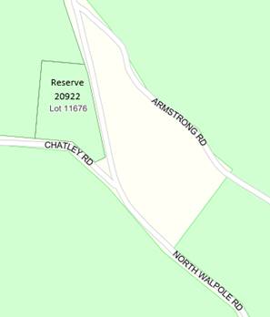
9.2.1 Proposed Change of Purpose for Reserves 13499 and 20922
|
PROPONENT |
Shire of Manjimup |
|
OWNER |
Crown (Management Order to Shire) |
|
LOCATION / ADDRESS: |
Reserve 13499 - Lots 13916 and 13917 Wheatley Coast Road, Crowea Reserve 20922 – Lot 11676 North Walpole Road, North Walpole |
|
WARD: |
East, Coastal, South |
|
ZONE: |
Public Purposes |
|
DIRECTORATE: |
Business |
|
FILE REFERENCE: |
F161123 |
|
LEGISLATION: |
Local Government Act 1995 Land Administration Act 1997 |
|
AUTHOR: |
Jasmine Bamess; Michael Leers |
|
DATE OF REPORT: |
6 January 2023 |
|
DECLARATION OF INTEREST: |
Nil |
Background:
The Shire of Manjimup has identified two Crown Reserves comprising of three land parcels with the current purpose of the reserves being ‘gravel’. Two of the parcels are no longer required for that purpose and it is recommended the reserve purpose is changed to ‘conservation’.
Changing the reserve purpose to ‘conservation’ will allow the Shire of Manjimup to designate the land as offsets for clearing permits.
PUBLIC Consultation Undertaken:
Nil.
COMMENT (Includes Options):
Reserve 13499 Wheatley Coast Road, Crowea, currently for the purpose of ‘gravel and parkland rehabilitation’ is comprised of Lots 13916 and 13917. It is proposed to separate the lots into two reserves.
Lot 13916 (9.6 hectares) is no longer required for gravel and is proposed to be changed to ‘conservation’. A basic survey of the site indicates that the quantity of gravel is low, and the quality is poor. This site offers further issues related to extraction due to the undulating terrain and significant clearing issues, and therefore holds a higher value for conservation offsets.
Lot 13917 (21.9 hectares) has a gravel deposit remaining and therefore it is proposed to retain the current purpose.
The Shire of Manjimup recently obtained a vegetation clearing permit for Old Vasse Road from the Department of Water and Environmental Regulation (DWER) with conditions including the purpose of parts of Lot 13916 of Reserve 13499 being changed to ‘conservation’ as an offset proposal. It is intended by the Shire that Lot 13916 will continue to be used as an offset to assist with DWER vegetation clearing permit approvals for any road works in the area, including Old Vasse Road and Wheatley Coast Road. The same intention stands for Lot 11676 North Walpole Road, as discussed below, to assist with the vegetation clearing permit approval process for the ongoing North Walpole Road works program.
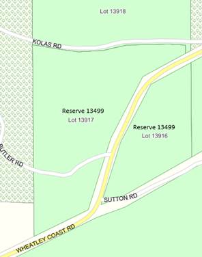
Reserve 20922, Lot 11676 North Walpole Road, North Walpole (2 hectares) has previously had the gravel extracted and therefore it is recommended to change the purpose and retain the reserve for ‘conservation’.
STATUTORY ENVIRONMENT:
Management orders are issued by the Department of Planning, Lands and Heritage for the reserve purpose in accordance with the Land Administration Act 1997.
Policy / Strategic Implications:
Council Policy 1.2.8 Authority to Execute Documents on Behalf of Council requires all matters concerning changes to the purpose of Crown reserves with management orders to the Shire to be put before Council for authorisation.
Organisational risk management:
Nil.
Financial Implications:
Nil.
Sustainability:
Environmental: Nil.
Economic: Nil.
Social: Nil.
VOTING REQUIREMENTS: SIMPLE MAJORITY
|
That Council authorise the Chief Executive Officer to make application to the Department of Planning to change reserve purposes as follows:
|
9.3.1 Monthly Financial Activity Statement - November 2022
|
PROPONENT |
Shire of Manjimup |
|
OWNER |
Whole Shire |
|
LOCATION / ADDRESS: |
Whole Shire |
|
WARD: |
Whole Shire |
|
ZONE: |
N/A |
|
DIRECTORATE: |
Business |
|
FILE REFERENCE: |
F160188 |
|
LEGISLATION: |
Local Government Act 1995; Local Government (Financial Management Regulations) 1996 |
|
AUTHOR: |
Greg Lockwood |
|
DATE OF REPORT: |
4 January 2023 |
|
DECLARATION OF INTEREST: |
Nil |
Background:
The Local Government (Financial Management) Regulations 1996 require monthly Financial Activity Statement reports to be prepared and presented to Council, containing the following information;
· Annual budget estimates;
· Estimates to end of month;
· Actual expenditure;
· Actual income;
· Material variances; and
· Net current assets.
The Financial Activity Statement report for the period to 30 November 2022 is attached. The report is summarised by Function/Activity with operating comments via department. The report also provides a Rate Setting Statement and Statement of Comprehensive Income in the Type format in anticipation of changes to monthly reporting requirements proposed by the Department of Local Government.
ATTACHMENT: 9.3.1 (1)
PUBLIC Consultation Undertaken:
Nil.
COMMENT (Includes Options):
The projected profit is based on a conservative approach highlighting possible issues as they occur, which in most cases can be rectified or offset with under expenditure in other areas as the Shire progresses through the financial year.
There have been no significant issues identified in the November 2022 accounts. One moderate issue that is unlikely to be rectified by the 30 June 2023 is PowerUp Energy Museum Income. Whilst we are now entering the period of higher use, a comparison of income to a pro rata of the year-to-date budget shows entry fees $30,000 behind budget, a conservative projection to the 30 June 2023 would show a loss of $55,000.
A positive issue to date is Interest on Bank Accounts, to the 30 November 2022 actuals were $81,884 with a whole year budget of $60,000. It is expected that the rate of interest generated will slow as we progress through the year with money being expended, but a conservative projection should see an additional $60,000 of additional income.
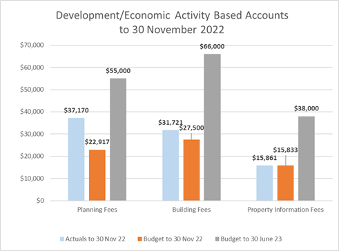
Development activity accounts again have shown strong performance in November. Planning Fees have jumped to $14,253 ahead of the year-to-date budget with Building Fees moving $4,221 ahead of the year-to-date budget. The graph shows a similar trend to last year, whilst the figures are slightly lower than November 2021, they show Planning Fees well ahead of budget and the continued high level of properties being sold compared to those years prior to the Pandemic.
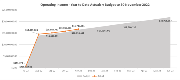
The graphs below reflect what the expected cumulative budget to 30 June 2023 is (grey area), with the line graph represented actuals to 30 November 2022.
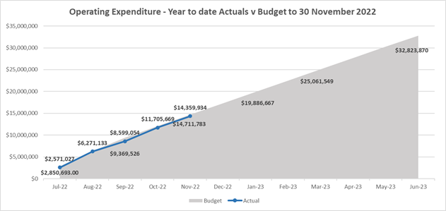
At present operating income to the 30 November 2022 is trending ahead of budget with actuals sitting at $16,717,361 compared to a budget of $16,433,444. Whilst a difference of $283,917 is significant, it is difficult to predict the timing of payments for special operating project grants. To date there are no areas of concern related to operating income.
Operating Expenditure is trending behind budget with actuals of $14,359,934 compared to a budget of $14,711,783, a difference of $351,849. This sort of variance is typical this time of year as one-off grant projects that are operating in nature, generally accelerate expenditure in the latter half of the year.
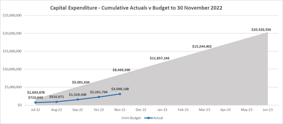
Capital expenditure is typically behind budget at this time of year as the majority of the Shire of Manjimup’s capital budget relates to Road Infrastructure works, which is very weather dependent. Of note, capital expenditure is $1,019,259 ahead of this time last year. The availability of contractors will also influence the Works Directorate progression through their budgeted projects. The Shire also has $5,160,000 of capital bridge works scheduled by Main Roads WA which influences capital actual expenditure comparison to budget, with only the Hatchery Road Bridge invoiced to date for $138,000.
Other than the grants listed above, no major discrepancies have come to light in the first five months after adopting the 2022/23 budget, and with appropriate adjustments for the additional grant funding, and with sound financial management going forward by all departments, Council should be in a neutral or minor surplus position at the 30 June 2023.
STATUTORY ENVIRONMENT:
Section 6.8 of the Local Government Act 1995 and Financial Management Regulation 34.
Policy / Strategic Implications:
Nil.
Organisational risk management:
Nil.
Financial Implications:
As described in above summary.
Sustainability:
Environmental: Nil.
Economic: Nil.
Social: Nil
VOTING REQUIREMENTS: SIMPLE MAJORITY
|
That Council receive the Monthly Financial Activity Statement Report for November 2022 as per Attachment: 9.3.1(1).
|
|
ATTACHMENTS |
||
|
1⇨ |
Monthly Financial Activity Statement - November 2022 |
16 Pages |
9.3.2 Council Financial Payments for November 2022
|
PROPONENT |
Shire of Manjimup |
|
OWNER |
N/A |
|
LOCATION / ADDRESS: |
Whole of Shire |
|
WARD: |
ALL |
|
ZONE: |
Whole of Shire |
|
DIRECTORATE: |
Business |
|
FILE REFERENCE: |
F160967 |
|
LEGISLATION: |
Local Government (Financial Management) Regulations 1996 |
|
AUTHOR: |
Greg Lockwood |
|
DATE OF REPORT: |
9 January 2023 |
|
DECLARATION OF INTEREST: |
Nil |
Background:
It is a statutory requirement for a list of payments from the Municipal and Trust Funds to be presented to Council and included in the minutes.
PUBLIC Consultation Undertaken:
Nil.
COMMENT (Includes Options):
The accounts for payment totalling $1,754,022.13 for the month of November 2022 are listed below and in the attachment.
ATTACHMENT: 9.3.2(1)
Vouchers for the expenditure are available for inspection at the Council Meeting of 19 January 2023.
|
Fund |
Vouchers |
Amount |
|
Municipal |
95160 – 95189 |
$109,731.61 |
|
Trust Fund |
- |
$0.00 |
|
Total Cheques for Month of November 2022 |
$109,731.61 |
|
Electronic Funds Transfer (EFT) expenditure batch reports are available for inspection at the Council Meeting of 19 January 2023.
|
Fund |
Batch |
Amount |
|
Municipal |
225 - 231 |
$1,644,290.52 |
|
Total EFT for Month of November 2022 |
$1,644,290.52 |
|
|
|
|
|
Corporate Credit Card transactions 21 September 2022 – 20 October 2022 (paid 2 November 2022) – Municipal Account
|
2.1388 |
Crown Perth – LG Convention Meal –1x staff, 2x non staff |
$291.46 |
|
2.1388 |
Crown Perth – LG Convention Accommodation – Cr Winfield |
$195.00 |
|
2.1388 |
Black and White Taxi – LG Convention |
$22.16 |
|
2.1388 |
Swan Taxi – LG Convention |
$27.46 |
|
2.1388 |
Live Taxi – LG Convention |
$21.83 |
|
2.1388 |
Meat & Wine Co – LG Convention Meal – 2x staff, 6x non staff |
$969.74 |
|
2.1388 |
Adobe Creative Cloud PDF App subscription |
$79.99 |
|
6.1391 |
St Catherines – LG Induction Training Accommodation – Corporate EA |
$186.00 |
|
570.1346 |
Starlink Subscription – Windy Harbour 22/9/22 – 21/10/22 |
$143.17 |
|
102.1192 |
AIBS – Annual membership - Manager Building Services |
$800.00 |
|
Various |
Westnet – Internet Access 1/11/22 – 1/12/22 |
$219.89 |
|
2.1388 |
Sunny Cabs – LG Convention |
$26.50 |
|
2.1388 |
Live Taxi – LG Convention |
$17.69 |
|
13.1294 |
1Password – Subscription 3 users 5/10/22 – 5/10/23 |
$481.05 |
|
19999.7266.70 |
Australian Taxation Office - August 2022 BAS |
$9,497.00 |
|
7.1014 |
Australian Taxation Office - August 2022 BAS Card Fee |
$73.13 |
|
13.1294 |
Screenconnect Software - Renewal |
$3,102.57 |
|
7.1317 |
Ocean Beach Hotel – Datacomm User Group Meeting Accommodation 3x staff |
$330.00 |
|
575.1101 |
Wild at Heart – Pemberton Hub Project Meeting Coffees 2x staff, 1 non staff |
$16.50 |
|
660.1294 |
Mantra on Hay – Attendance Royal Show Accommodation – Corporate Administration Officer |
$1,176.88 |
|
575.1299 |
Perth Airport – Attendance at Australian Regional Tourism Conference (ART) - Parking – Director Community Services |
$120.39 |
|
575.1299 |
Ingot Hotel – Attendance at ART Conference Pre-flight accommodation – Director Community Services |
$292.76 |
|
575.1299 |
Ingot Hotel – Attendance at ART Conference (Adjustment) |
($101.30) |
|
575.1299 |
Red Rooster Baldivis – Attendance at Art Conference Refreshments – Director Community Services |
$12.95 |
|
575.1299 |
Station Refreshments – Attendance at ART Conference Refreshments – Director Community Services |
$6.30 |
|
575.1299 |
Ballarat Taxi – Attendance at ART Conference Director Community Services |
$17.11 |
|
575.1299 |
Mercure Ballarat – Attendance at ART Conference Accommodation – Director Community Services |
$864.41 |
|
575.1299 |
Delaware North – Attendance at ART Conference Refreshments – Director Community Services |
$11.80 |
|
97.1411 |
Microsoft 365 Family Plan – Bush Fire Brigades Subscription |
$129.00 |
|
98.1411 |
Microsoft 365 Family Plan – Manjimup SES Subscription |
$129.00 |
|
99.1411 |
Microsoft 365 Family Plan – Walpole SES Subscription |
$129.00 |
|
Total Credit Card Payments for November 2022
|
$19,289.44
|
|
STATUTORY ENVIRONMENT:
Local Government (Financial Management) Regulations 1996, Regulations (12) and (13).
Policy / Strategic Implications:
Nil.
Organisational risk management:
Nil.
Financial Implications:
As stated.
Sustainability:
Environmental: Nil.
Economic: Nil.
Social: Nil.
VOTING REQUIREMENTS: SIMPLE MAJORITY
|
|
ATTACHMENTS |
||
|
1⇨ |
Creditor Payment Report - November 2022 |
28 Pages |
9.3.3 Council Financial Payments for December 2022
|
PROPONENT |
Shire of Manjimup |
|
OWNER |
N/A |
|
LOCATION / ADDRESS: |
Whole of Shire |
|
WARD: |
ALL |
|
ZONE: |
Whole of Shire |
|
DIRECTORATE: |
Business |
|
FILE REFERENCE: |
F160967 |
|
LEGISLATION: |
Local Government (Financial Management) Regulations 1996 |
|
AUTHOR: |
Greg Lockwood |
|
DATE OF REPORT: |
9 January 2023 |
|
DECLARATION OF INTEREST: |
Nil |
Background:
It is a statutory requirement for a list of payments from the Municipal and Trust Funds to be presented to Council and included in the minutes.
PUBLIC Consultation Undertaken:
Nil.
COMMENT (Includes Options):
The accounts for payment totalling $1,852,700.09 for the month of December 2022 are listed below and in the attachment.
ATTACHMENT: 9.3.3(1)
Vouchers for the expenditure are available for inspection at the Council Meeting of 19 January 2023.
|
Fund |
Vouchers |
Amount |
|
Municipal |
95190 - 95212 |
$154,045.20 |
|
Trust Fund |
- |
$0.00 |
|
Total Cheques for Month of December 2022 |
$154,045.20 |
|
Electronic Funds Transfer (EFT) expenditure batch reports are available for inspection at the Council Meeting of 19 January 2023.
|
Fund |
Batch |
Amount |
|
Municipal |
232 - 236 |
$1,698,654.89 |
|
Total EFT for Month of December 2022 |
$1,698,654.89 |
|
|
|
|
|
Corporate Credit Card transactions 21 October 2022 – 20 November 2022 (paid 2 December 2022) – Municipal Account were unavailable at the time the agenda period closed and will be supplied at the next Council meeting.
STATUTORY ENVIRONMENT:
Local Government (Financial Management) Regulations 1996, Regulations (12) and (13).
Policy / Strategic Implications:
Nil.
Organisational risk management:
Nil.
Financial Implications:
As stated.
Sustainability:
Environmental: Nil.
Economic: Nil.
Social: Nil.
VOTING REQUIREMENTS: SIMPLE MAJORITY
|
|
|
|
|
ATTACHMENTS |
||
|
1⇨ |
Creditor Payment Report - December 2022 |
34 Pages |
9.5.1 Proposed Low Impact Tourist Accommodation Lot 9875, 384 Boorara Road, Boorara Brook
|
PROPONENT |
Mr W S Rudd |
|
OWNER |
Mr W S & Mrs A S Rudd |
|
LOCATION / ADDRESS: |
Lot 9875, 384 Boorara Road, Boorara Brook |
|
WARD: |
Coastal |
|
ZONE: |
Priority Agriculture |
|
DIRECTORATE: |
Statutory Planning |
|
FILE REFERENCE: |
DA22/183 & P55785 |
|
LEGISLATION: |
Planning and Development Act 2005 |
|
AUTHOR: |
Karleha Brown/Brian Robinson |
|
DATE OF REPORT: |
12 December 2022 |
|
DECLARATION OF INTEREST: |
Nil |
Background:
An application has been received for a Low Impact Tourist Accommodation (Nature Based Caravan Park) at Lot 9875, 384 Boorara Road, Boorara Brook. A location plan is shown below.
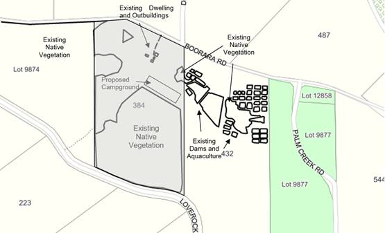
The subject property is 53.684ha and is located 4.5 kilometres from the intersection of Boorara Brook and Windy Harbour Road and in totalling approximately 6.9km from the Northcliffe town centre. The property contains a dwelling and three outbuildings. There are two small dams located in the northwest corner of the property between the dwelling and Boorara Brook Road. Approximately half the property is pasture to the north and the other remnant vegetation to the south.
The applicant is proposing to use an area approximately 200 metres long by 40 metres deep (8,000m²) as a Low Impact Tourist Accommodation (Nature Based Caravan Park) for up to 5 self-contained vehicles only. As detailed on the submitted plans, the camping area will be setback 21 metres from forest type vegetation located to the southeast of the existing dwelling. Information provided by the applicant indicates that campsites will be separated by a minimum of 10 metres, significantly limiting the number of campsites available.
A copy of the submitted Fire Management Plan, which includes plans relating to the proposal is attached.
ATTACHMENT: 9.5.1 (1)
Council is requested to consider the application as Shire Officers do not have the delegated authority to determine applications for a Low Impact Tourist Accommodation in a Priority Agriculture Zone.
PUBLIC Consultation Undertaken:
The proposal was advertised in accordance with clause 9.6 of the Shire of Manjimup’s Local Planning Scheme No. 4 (the Scheme) to the neighbouring landowners for a period of 21 days and to the Department of Fire and Emergency (DFES) and the Department of Planning, Lands and Heritage for a 42-day period.
In response, two (2) submissions were received from DFES and a neighbouring landowner. The submissions are attached, and comments made are outlined in the comment section of the report.
ATTACHMENT: 9.5.1 (2)
COMMENT (Includes Options):
The subject land is zoned Priority Agriculture by the provisions of the Scheme. In determining an application for planning approval, Clause 10.2 of the Scheme requires that various matters are taken into account, including but not limited to:
“(i) the aims and provisions of the Scheme and any other relevant Local Planning Scheme operating within the Scheme area;
(iii) any approved State Planning Policies of the Commission;
(xiv) whether the land to which the application relates is unsuitable for the proposal by reason of it being, or being likely to be, subject to flooding, tidal inundation, subsidence, landslip, bush fire or any other risk.”
Zoning Purpose
The purpose of the zone is to provide for the sustainable use of high quality agricultural land, particularly where water resources exist, preserving existing agricultural production and allowing for new agricultural production by securing suitable land and water resources.
Consistent with the purpose, an objective for the zone relevant to this application is to low impact tourist accommodation – short stay proposals where relevant, provided that any impact from any such land uses or development is contained on-site.
Land Use Definition
‘Low Impact Tourism Accommodation’ means that the use and development of land in such a manner that does not detract from the rural and natural amenity of the locality, and includes the following criteria –
“(a) development being located so as to avoid ridge line, escarpments or visually exposed sites and situated where screening vegetation or landform can be utilised;
(b) use and development being sensitively located and designed to minimise impact on vegetation, water courses, soils quality and existing land uses;
(c) development being of a scale and nature so as to be self-sustaining on the lot, or demonstrating the ability to provide servicing without significant modifications to existing infrastructure;
(d) development that by the nature of its scale, design, colours, materials, landscaping and use, has minimal impact on its site and surrounding areas; and
(e) where the land use and any development had minimal off-site consequence.”
In terms of the proposed accommodation location, the site is located so as to minimise the impact on vegetation, water courses etc and the low key nature of the proposal will have minimum impact on the site and surrounding areas. Although the location is positioned where the occupants would be visible from the road, it is situated over 250 metres from the road frontage.
Land Use Permissibility
A Low Impact Tourism Accommodation is an ‘A’ use in the Priority Agriculture zone. That is a use not permitted unless the local government has exercised its discretion by granting planning approval after giving special notice in accordance with Clause 9.6 of the Scheme.
Land Use Classification
The Scheme defines a Caravan Park as an area set aside for the parking of caravans under the by-laws of local government or the Health Act (Caravan Parks and Camping Grounds) Regulations 1974, made pursuant to the provisions of the Health (Miscellaneous Provisions) Act 1911, or any amendment thereto, or any regulation or by-laws from time to time standing in place of them.
It should be noted that the Health Act (Caravan Parks and Camping Grounds) Regulations 1974 have been superseded by the Caravan Park and Camping Grounds Act 1995 and the associated Caravan Parks and Camping Grounds Regulations 1997.
Nature Based Caravan Park Provisions
Under the Caravan Park and Camping Grounds Regulations 1997 (the Regulations), Caravan Park’s may be registered under one of several definitions, with the level of facilities required dependant on the type of licence obtained. In accordance with the Regulations, a Nature Based Caravan Park is a facilitate that:
(a) Is not in close proximity to an area that is built up with structures used for business, industry or dwelling houses at intervals of less than 100m for a distance of 500m or more;
(b) Has predominately been formed by nature; and
(c) Has limited or controlled artificial light and noise intrusion.
To meet the definition of a Nature Based Park the applicant has outlined the following details;
· The applicant has stated only 5 camping sites are available approximately 10m apart.
· The camping site is only available for fully self-contained campers only. No facilities such as power, water, potable water, hard or liquid waste outlets or ablution or cooking amenities will be provided on the site.
· The duration of stay is limited to a maximum of 3 nights.
· Advertising of the Nature Base Park will be undertaken online through a booking provider.
· Access will be taken from Boorara Brook Road, the internal access road is a 280m long two wheeled access road.
· Fire Management measures proposed by the applicant to be implemented in accordance with the submitted Fire Management Plan.
Although the existing home and associated infrastructure is located around 100m from the western edge of the camping area, the locality is rural in nature, and it not considered to be a built up area and there is limited artificial light or noise intrusion.
The Caravans or other Recreational Vehicles (RV’s) are to be parked on a disused airstrip located 21m north of a 25ha (approx.) area of native vegetation. The balance of the property, whilst cleared of vegetation, appears to retain its original topography. Whilst Nature Based Camping Areas are expected to be largely formed by nature, some alterations of contours is normally expected in any form of caravan park to provide level areas for camping. It is therefore considered the proposal is consistent with the requirement for the area to be largely formed by nature.
It is also noted that:
· The Subject property is approximately 6.9km from the Northcliffe Town site.
· The regulations require one site per 50 sqm, in this instance the camp site is approximately 10,000m². The proposed 5 sites are well within this requirement.
· Self-contained vehicles are generally only fully self-supporting for 3 – 7 days, the maximum availability of a 3 night stay is in keeping with this requirement.
· Entrance roads and two way roads within the nature based park are to be 6 metres in width, one way 4 metres in width;
· Although facilities road are to be constructed and maintained as is approved, they need not be paved or sealed;
· No fire extinguisher or tap is proposed within the facility; and
· No rubbish bins are proposed to be provided.
With respect to rubbish bins, it is expected that any rubbish generated on the site by customers should be disposed of by the applicant to prevent rubbish being disposed within street bins for example after occupants leave the site. It is recommended a bin be provided on-site and maintained by the applicant.
State Planning Policy 3.7 (SPP No 3.7) – Planning in Bushfire Prone Areas
The property is located within an area declared as ‘bushfire prone’ by the Fire and Emergency Services Commissioner under the Fire and Emergency Services Act 1998. The applicant has had a Bush Fire Management Plan and Bush Fire Emergency Evacuation Plan prepared.
The report prepared by Bio Diverse Solutions on behalf of the applicant identifies the bushfire risk as Extreme Bush Fire Hazard Level due to the continuous vegetation to the south west of the subject camping site. Although the area set aside for camping ranges from a 12.5 to a 29 BAL, it should be noted that the occupants will not be in permanent structures and will be moveable, able to leave the area in the event of a bushfire.
As outlined within the submitted Bushfire Emergency Evacuation Plan, the landowner will be responsible for, amongst other things, daily monitoring of the Fire Danger Rating and will ensure that the campground is closed when the “Catastrophic Fire Danger Rating” is applied. The potential risks to guests during the event of a fire is reduced, given the Manager/owner resides on the subject property and through effective communication and warning signs of the extreme risk.
It is however noted that the map shown on page 10 indicates a “place of last resort”. Further comment on this approach is provided in response to the submission received from DFES below.
In terms of access, access to and from the site is available to the west or east along Boorara Road. Movement to the west is identified as being the safer route given the availability to move on to developed linkage roads quicker and easier.
The proposal is consistent with the definition of vulnerable land use being a land use where persons may be less able to respond in a bushfire emergency, including short-stay accommodation where users are unaware of their surroundings and may need assistance or direction in the event of a bushfire.
DFES Submission
The submission received from Department of Fire and Emergency Services (DFES) recommends not to support the proposed development due to their interpretation that the proposal does not fully comply with Planning for Bushfire Guidelines. The DFES Officer highlights that the application does not meet the intent of Element 5: Vulnerable Tourism Land Uses as the proposal seeks to intensify the land use of the subject property in with an extreme bushfire hazard both in and surrounding the subject property. DFES recommends a number of modifications to the BMP to respond to the areas of non-compliance to influence appropriate bushfire management measures.
The landowner has arranged for their Bushfire Consultant to liaise with Shire Officers and DFES representatives to discuss the recommended modifications to the BMP. As a minimum reference to a “last place of resort” needs to be removed from the BMP and comments made by DFES in terms of access needs to be considered.
The above said, it must be acknowledged that the landowner/operator resides on site and they will be monitoring the Fire Danger Rating Index, closing the facility during periods of Catastrophic Fire Danger. For these reasons, conditional approval is recommended.
Other Submissions Received
At the time of writing this report there was one submission received from a neighbouring landowner who operates a similar tourism business “Northcliffe Bush Camp” previously known as “Sid’s Camp Ground” which is southwest of the subject property. The submission raises concern that the proposed site does not meet the definition of a “Nature Based Park” and is unsuitable.
The submission raises comment that the proposed location of the camping ground is not nature based due to;
· the proposed site being a previously operational air strip;
· the proximity of the proposed camp site to the existing dwelling and neighbouring Aquaculture Ponds; and
· the lack of buffer to limit or control artificial light and noise intrusion from Boorara Brook Road to the camp site.
As detailed under the heading “Caravan and Camping Grounds Regulations 1997”, the landowner’s residence and outbuildings associated with the rural use of the property are located approximately 100 metres from the western edge of the camping area. It is also noted that an Aquaculture farm established on the neighbouring property to the east is also approximately 70m setback to the closest pond wall.
The Regulations state that a nature based park prime consideration is whether the location is in a primarily undisturbed natural setting surrounded by vegetation. A natural landscape can also include an agricultural setting. In this instance the location of the camping area does offer an agricultural setting with the ability for the guests to enjoy both the agricultural as well as a native vegetated landscape that is on offer on the subject property.
The proposed location of the camping area is setback approximately 280m from Boorara Brook Road. The potential impact to the campers in way of noise and artificial light is considered to be minimal given Boorara Brook Road is only a road servicing various farms east of the subject property. The setback distance of 280m from Boorara Brook Road, will also provide a sufficient distance to reduce the potential impact to the campers from the road. The planting of additional screen vegetation could further reduce the impact and is recommended.
The submission received also questions the need for an additional facility in the Northcliffe area, expressing the view that the proposal fails to demonstrate how it will result in net community benefit. It should be noted that the existing facilities and commercial competition are not valid planning considerations. It is considered that the proposed facility is very small scale and will provide an opportunity for a different camping experience in proximity to the Northcliffe townsite.
Recommendation
The development as proposed is consistent with the definition of a Low Impact Tourism and the rural/bush outlook of the camping area is considered to be consistent with the definition of a Nature-Based Caravan Park.
Irrespective of the application achieving compliance with the Scheme and Regulations, DFES has identified that in their opinion the current Bushfire Management and Evacuation Plans fail to meet the State Planning Policy 3.7 Planning in Bush Fire Prone Areas. Whilst the submitted consultants report indicates that in their view the proposal complies, Shire Officers agree that some modification of the documents is required prior to commencement of the proposal and the consultant is currently liaising with DFES regarding the recommended modifications.
Notwithstanding that some modification of the Bushfire documentation is required, the fact the owner resides on the site and there will be a requirement for the facility to close during periods of Catastrophic Fire Danger, dramatically reduces the potential risk to campers. It is therefore recommended that conditional approval be granted.
Notwithstanding the above, it is recommended that a condition be imposed to require revision of the Bushfire Management Plan and Bushfire Emergency Evacuation Plan to the satisfaction of the Shire’s Community Emergency Services Manager prior to commencement of the activity.
STATUTORY ENVIRONMENT:
Planning and Development Act 2005, Caravan and Camping Grounds Act 1995, Local Planning Scheme No. 4 and State Planning Policy 3.7 Planning in Bushfire Prone Areas.
Policy / Strategic Implications:
Approval to the application is consistent with Strategy B12 of the Shire of Manjimup’s Strategic Community Plan 2021 – 2031, being to “provide development opportunities and support local small businesses to thrive.”
Organisational risk management:
In determining the application, due care needs to be taken to ensure that fire risks associated bushfire are minimised.
Financial Implications:
The required development application fees have been paid by the applicant.
Sustainability:
Environmental: The proposed nature based camp is sympathetic to the environment and the proposed scale will not cause a negative impact on the natural environment.
Economic: The proposed business will provide the landowner with an additional source of income and the tourists will benefit the area by bringing business to Northcliffe and surrounding town sites.
Social: Management Plans addressing all potential risks associated with the intensification of the subject property needs to be appropriately addressed in accordance with the Scheme and other relevant State Policies.
VOTING REQUIREMENTS: SIMPLE MAJORITY
|
That Council grant approval to the proposed Low Impact Tourism Accommodation (Nature Based Park) at Lot 9875, 384 Boorara Brook Road, Boorara Brook subject to compliance with the following conditions: 1. The development hereby approved is to be carried out generally in accordance with the plans and specifications submitted with the application and these shall not be altered and/or modified without the prior knowledge and written consent of the Shire of Manjimup:
2. The Low-Impact Tourist Accommodation shall close to guests and not operate during period of Catastrophic Fire Danger; 3. Prior to commencement of the use hereby approved, the applicant shall Amend the Bushfire Management/Evacuation Plan reflecting the changes to ensure compliance with the requirements of the State Planning Policy No 3.7 and the Western Australian Planning Commissions Position Statement – Tourism Land Uses in Bushfire Prone Areas to the satisfaction of the Shire’s Community Emergency Services Manager Department; 4. Prior to commencement of the use hereby approved, the internal caravan park roads shall be constructed of gravel or other material to the satisfaction of the Shire of Manjimup; 5. Prior to commencement of the use hereby approved, all management measures contained within the Bushfire Management Plan/Evacuation Plan as approved shall be implemented to the satisfaction of the Shire of Manjimup; 6. The Low Impact Tourist Development – Short Stay hereby approved is limited to a maximum of twenty (20) persons on the premises at any one time to the satisfaction of the local government, as provided in Shire of Manjimup Local Planning Scheme No. 4; 7. The landowner ensuring that all vehicles are fully self-contained, that is contain their own toilet, shower and cooking facilities; 8. No individual is not to occupy the accommodation for more than twenty-eight (28) days within three (3) month period as provided in the Nature Based Park Guidelines, December 2014. In this regard, the Manager/Operator is to maintain a register of guests and the duration of their occupation to the satisfaction of the Shire of Manjimup, and the register shall be made available for perusal by Shire Officers on demand; 9. The submitted management details which form part of the application, shall be implemented on an ongoing basis to the satisfaction of the Shire of Manjimup; 10. Rubbish storage areas are to be designed and located to minimise noise, odour, visual intrusion and/or other factors potentially adversely affecting the character and/or amenity of Nature Based Park users and properties in the vicinity to the satisfaction of the Shire of Manjimup. Advice notes: (i) This Development Approval is NOT a building permit. A building permit must be formally applied for and obtained from Building Services prior to any use of the existing building for purposes associated with the use hereby approved; and (ii) This Development Approval is NOT a Caravan Park License. A license to operate the park must be obtained prior to campers attending the property. |
|
ATTACHMENTS |
||
|
1⇨ |
Attachment No 1 - Proposed Bushfire Management Plan and BAL Assessment |
81 Pages |
|
2⇨ |
Attachment No 2 - Submissions Recieved as a result of advertising |
6 Pages |
9.5.2 Retrospective Development and Proposed Change of Use to Dwelling at Lot 4, (No 25) Wheatley Coast Road, Northcliffe
|
PROPONENT |
Wittenoom Consulting Engineers |
|
OWNER |
Mr P R Rowe |
|
LOCATION / ADDRESS: |
Lot 4 (No 25) Wheatley Coast Road, Northcliffe |
|
WARD: |
Coastal |
|
ZONE: |
Town Centre |
|
DIRECTORATE: |
Statutory Planning |
|
FILE REFERENCE: |
DA22/194 & P55629 |
|
LEGISLATION: |
Planning and Development Act 2005 |
|
AUTHOR: |
Karleha Brown/Brian Robinson |
|
DATE OF REPORT: |
22 December 2022 |
|
DECLARATION OF INTEREST: |
Nil |
Background:
Lot 4 (No 25) Wheatley Coast Road, Northcliffe is a 1012m² lot located on the western side of Wheatley Coast Road in Northcliffe, midway between Richards and Boronia Streets. The location of the subject property is shown below.
Location Plan
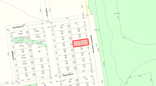
In 2005 approval was granted to the construction of a 9m by 12m shed on the property, located approximately 32m from the front boundary. The applicant is now seeking approval to change the use of the building to a dwelling and retrospective approval for a transportable building containing ablution facilities.
Plans submitted in support of the application detail that the dwelling will comprise 2 bedrooms, an open kitchen, dining and lounge area within the front 9m of the existing building and a workshop/activities room in the rear 3 metres. A covered way is proposed to connect the proposed dwelling to the ablution facilities being located 1.2m in front of the existing building. A copy of the development plan is attached.
ATTACHMENT: 9.5.2(1)
Council is requested to determine the application as it in involves retrospective approval to the transportable ablution facilities and Shire Officers do not have the authority to determine retrospective applications.
PUBLIC Consultation Undertaken:
The proposal was referred to the adjoining neighbours for comment for a period of 21 days. No comments were received during this period.
COMMENT (Includes Options):
The property is zoned Town Centre with a density of R10 by Local Planning Scheme No. 4 (the Scheme), with a density of R10/R20. As the R20 density is subject to the availability of reticulated sewerage, development is required to comply with the requirements relating to R10 under the State Planning Policy 7.3 – Residential Design Codes Volume 1 (the R-Codes).
To guide Council on the determination of this application, the following comments are offered:
Matters to be considered
In determining an application for planning approval, the local government is required to have regard to various matters as outlined within Clause 10.2 of the Scheme. These matters include, but are not limited to: -
(i) the aims and provisions of the Scheme and any other relevant Local Planning Scheme operating in the district;
(iii) any approved State Planning Policies of Commission;
(xv) the preservation of the amenity of the locality; and
(xxvi) any relevant submissions received on the application.
Any assessment against the above criteria is provided within the balance of this agenda item.
Land Use Permissibility
A Dwelling – Single is a ‘D’ land use in a Town Centre Zone, that is a use that is not permitted unless the local government has exercised its discretion by granting planning approval. In this instance the subject property is in a vicinity where residential development has been established. Approval to a dwelling would be keeping with the prevailing land use in the immediate area.
R-Codes
The dwelling is located to the rear of the subject property, 5m from the rear boundary and 5m from the boundary to the south, 4m to the northern boundary and 26m from the boundary fronting Wheatley Coast Road. All setback distances are in keeping the setback requirements for an R10 zone.
The application is compliant with the requirements outlined within the deemed to comply provisions of the R-Codes.
Amenity
Clause 5.12 of the Scheme sets out the relevant considerations relating to amenity that must be considered when determining an application for planning approval. These matters include:
· The external appearance of the building and associated structures and landscaping;
· The materials to be used in the construction of the building taking into consideration texture, scale, shape and colour; and
· Any other matter which in the opinion of the local government is relevant to the amenity of the area.
To assist Council in considering the proposed development, its relationship with the adjacent development, streetscape and general amenity of the area, the following comments and advice are offered:
Form of Construction
Whilst the use of a steel shed as the primary structural components of a dwelling is not unusual within the Shire, such approaches are not common within standard residential areas or town centres, particularly where the building is clad in zincalume. It is also unusual for development to involve the use of a transportable or modular ablution building in front of the primary structure.
Due consideration must therefore be given the visual impact/appearance of the building.
Adjacent Development
An examination of the adjacent development has identified that:
a) Lot 3 (No 27) to the north of the subject land is vacant and is also owned by the subject landowner;
b) Lot 2 (No 29), located north of the vacant block is developed with a simple design single storey dwelling of framed construction with weatherboard style cladding;
c) Lot 5 (No 23) to the south is developed with a relatively small 88m² dwelling clad in colourbond material; and
d) Lot 6 (No 21) is developed with a single row of motel units of brick construction.
Whilst clad in zinaclume rather than colourbond or weatherboard style materials, the proposed development is not inconsistent with the residential dwellings located to the north and south.
Photographs of the adjacent development are shown attached.
ATTACHMENT: 9.5.2(2)
Streetscape
As demonstrated by the photographs shown at Attachment: 9.5.2(2), views of the development are restricted by existing vegetation located at the front of the property. As a result, the development is most visible when viewed from Wheatley Coast Road to the north of the development.
It is considered that the addition of the proposed doors and window to the north face of the existing outbuilding, will when combined with the proposed verandah, give the development a more residential appearance.
Landscaping/Vegetation
The submitted plans do not indicate any proposed landscaping or other proposed property improvements. However, the existing vegetation limits the visual impact of the development when view from the adjacent street. It is recommended a condition be imposed to require the retention of the existing vegetation, unless otherwise approved.
Vehicle Access
Vehicle access will be off Wheatley Coast Road and a condition requiring construction of a crossover to the Shire’s satisfaction is recommended. It is considered that as there is sufficient space between the dwelling and Wheatley Coast Road on the subject property for car parking and manoeuvrability.
State Planning Policy 3.7 Planning in Bush Fire Prone Areas
The subject property has been identified as being in a designated bushfire prone area. A BAL assessment report has been submitted in conjunction with this application reporting a level of 12.5 for the subject property.
This assessed level is considered to be a low fire risk rating.
Recommendation
In many circumstances the use of zincalume style cladding for a residence located within a townsite would not be considered suitable from a visual impact perspective. However, in this case, the existing vegetation abutting the front boundary significantly reduces this impact and the appearance of the development will in officers opinions be improved by the installation of the opening and verandah as proposed.
Given the above and the fact no objections were received, it is recommended that the proposed change of use and retrospective approval to the transportable ablutions be granted.
STATUTORY ENVIRONMENT:
Planning and Development Act 2005 and Shire of Manjimup Local Planning Scheme No. 4.
Policy / Strategic Implications:
Approval to the application as submitted would be consistent with the following Community Goals and Strategies as outlined within the Shire of Manjimup Strategic Community Plan 2021-2031:
Community Goals
2.4 Industry and development is not hindered by excessive or complex regulations.
Strategies
B10. Ensure that the regulatory environment is easy to navigate and development, business and industry friendly.
Organisational risk management:
Nil.
Financial Implications:
The development application fee for retrospective approval has been paid by the applicant.
Sustainability:
Environmental: Nil.
Economic: Nil.
Social: Approval to the application will result in an additional dwelling within the Northcliffe Town Centre.
VOTING REQUIREMENTS: SIMPLE MAJORITY
|
That Council In accordance with Part 10 of the Shire of Manjimup Local Planning Scheme No. 4 grant retrospective planning approval to the dwelling and proposed extensions at Lot 4, 25 Wheatley Coast Road, Northcliffe (Application TP191/2022) in accordance with the plans and specifications shown at Attachment 9.5.2(1) subject to the following conditions and advice:
1) The development permitted shall be carried out generally in accordance with the plans and specifications submitted as listed below:
2) The dwelling hereby approved and all identified improvements to the existing building are to be substantially completed within 2 years of the date of this approval unless otherwise extended by the Shire of Manjimup; 3) Unless otherwise approved by the Shire of Manjimup, the existing vegetation located adjacent to the front boundary is to be retained for the life of the development; and Advice to the Applicant: i. This Development approval is NOT a building permit. A building permit must be formally applied for and obtained from Building Services BEFORE the commencement of any site and/or development works. ii. The development the subject of this planning approval, must comply with the requirements of the Health (Miscellaneous Provisions) Act 1911 and the Shire of Manjimup’s Health Local Laws 2020. |
|
ATTACHMENTS |
||
|
1⇨ |
Site, Elevation and Floor Plans for Lot 4 Wheatley Coast Road, Northcliffe |
1 Page |
|
2⇨ |
Attachment No 2 - Photographs of Adjacent developments |
4 Pages |
APPENDIX
9.5.3 Proposed Modification of Car Parking - Pemberton Co-location Project at No 61 (Lot 500 - Reserve 46734) Brockman Street, Pemberton
|
PROPONENT |
Shire of Manjimup |
|
OWNER |
Crown Reserve |
|
LOCATION / ADDRESS: |
No 61 (Lot 500/Reserve 46734) Brockman Street, Pemberton |
|
WARD: |
West |
|
ZONE: |
Public Purposes |
|
DIRECTORATE: |
Development & Regulation |
|
FILE REFERENCE: |
DA20/157 & P58100 |
|
LEGISLATION: |
Planning and Development Act 2005 |
|
AUTHOR: |
Brian Robinson |
|
DATE OF REPORT: |
4 January 2023 |
|
DECLARATION OF INTEREST: |
Nil |
Background:
The Shire of Manjimup holds a Management Order over the 2,389m² Crown Reserve located on the northern side of Brockman Street between Doc Ryan Place and Hepple Place as shown on the location plan below.
Location Plan
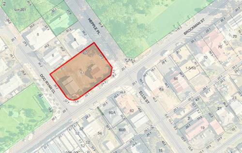
At its Ordinary Meeting held on 15 October 2020 Council resolved to grant conditional approval to the Pemberton Community Co-location Project, now known as Balang Miya Pemberton Community Hub. The reserve previously comprised two lots, being 242 and 288 which have since been amalgamated.
On 4 March 2021, Council was requested to reconsider a number of the conditions imposed on the development, including a reduction in the number of parking bays on Hepple Place from 10 bays to 9 bays. Council resolved to support the reduction on the basis of the proximity of the public parking located opposite the Pemberton Hotel (50 metres from the site) and the existing parking adjacent to the existing Pemberton Centre (150 metres from the site). A copy of the revised site plan as supported by Council is appended.
APPENDIX: 9.5.3(A)
Council is requested to consider a situation where the location of new Western Power infrastructure (power dome) will prevent the establishment of the parking bays off Hepple Place and a footpath as shown on the approved plans.
PUBLIC Consultation Undertaken:
Nil.
COMMENT (Includes Options):
As detailed in the background section, Western Power have commenced the installation of a new power service (via a green dome) for the development. The dome is located approximately 1.2m from an existing retaining wall off Hepple Place. As a result of the location of this dome, it is not possible to provide an accessible compliant parking bay as reflected on the approved plans.
Furthermore, telecommunications infrastructure in proximity to the new power service is located within the path alignment to the west of the accessible parking bay. As this infrastructure has been installed at natural ground level and lifting of the communications pit will result in additional costs.
The above factors have resulted in Shire Officers reconsidering the parking and path designs in this area and are now proposing to:
a) Setback the parking area approximately 2 metres from the existing retaining wall;
b) Establish two standard parking bays between the retaining wall and accessible parking bay, effectively relocated the accessible bay so as to be in-line with the central walkway located between the Museum and Community Arts buildings;
c) Construct all parking bays at a level so as to meet the now existing path, removing the need to install kerbing;
d) As the accessible bay will be constructed at the same height as the now existing concrete path, delete the proposed hatched area and associated access ramp in favour of a 3.2m wide accessible parking bay; and
e) Delete the proposed path connection back to Hepple Place and Brockman Street.
A plan demonstrating the proposed changes is shown attached.
ATTACHMENT: 9.5.3(1)
Through modifying and relocating the accessible parking bay and deletion of the path connection to Hepple Place as proposed, it will still be possible to establish a total of nine parking bays. Should Council not support the suggested design modifications, it will be necessary to delete one parking bay or alternatively incur additional costs to modify power and telecommunications infrastructure.
In terms of deleting the associated path connection back to Hepple Place, it should be noted that this will have little to no effect given that:
i) The accessible parking bay is proposed to service the development and compliant access will be provided directly into the development;
ii) There is in Shire Officers opinion no need to provide an accessible compliant footpath connection back to Brockman Street. Detailed examination of the site contours has confirmed that the existing slope would not comply with gradients to achieve accessible compliance in any event; and
iii) The footpath connection with the carparking area opposite the Pemberton Hotel will still have a suitable connection to the paved verge on Brockman Street, facilitating access through the main entrances off Brockman Street.
Whilst the proposed changes will mean facilities will not be established in accordance with the design approved by Council in March 2021, the revised design will comply with the Scheme and accessibility access requirements. As a result, it is recommended that Council unconditionally support the revised design.
STATUTORY ENVIRONMENT:
Planning and Development Act 2005 and Local Planning Scheme No 4.
Policy / Strategic Implications:
Nil.
Organisational risk management:
Nil.
Financial Implications:
The subject development is a Shire project funded by both the Shire and grant funding. It is anticipated that the modifications to the parking design will not result in any additional costs to the project, with the reduced footpath construction and deletion of kerbing offsetting any minor additional costs that may be incurred.
Sustainability:
Environmental: Nil.
Economic: Should the proposed modification of the parking and footpath design not be supported; additional costs will be incurred to modify the location of the power connection and telecommunications infrastructure.
Social: Nil.
VOTING REQUIREMENTS: SIMPLE MAJORITY
|
That Council support the proposed changes to the design of the parking area and footpath of Hepple Place relating to the proposed Civic and Community Purposes Redevelopment at Reserve 46734 Brockman Street and Lot 288 Hepple Place, Pemberton (Application TP138/2020) as shown at Attachment: 9.5.3(1).
|
|
ATTACHMENTS |
||
|
1⇨ |
Attachment No 1 - Revised Plan of Parking and Path Networks in Hepple Place |
1 Page |
|
APPENDICES |
||
|
a⇨ |
Appendix A - Site Plan as approved by Council on 21 March 2021 |
|
9.5.4 Delegated Planning Decisions for November 2022
|
PROPONENT |
Shire of Manjimup |
|
OWNER |
Various |
|
LOCATION / ADDRESS: |
Various |
|
WARD: |
Various |
|
ZONE: |
Various |
|
DIRECTORATE: |
Development & Regulation |
|
FILE REFERENCE: |
F170085 |
|
LEGISLATION: |
Planning and Development Act 2005 Local Government Act 1995 |
|
AUTHOR: |
Kaylee Blee |
|
DATE OF REPORT: |
5 January 2023 |
|
DECLARATION OF INTEREST: |
Nil |
Background:
In order to ensure the efficient and timely processing of planning related applications, Council delegates authority to the Chief Executive Officer to conditionally approve applications for Development Approval that meet the requirements of both Local Planning Scheme No 4 (the Scheme) and adopted Planning Policy.
Delegated planning decisions are reported to Council on a monthly basis to ensure that Council has an appropriate level of oversight on the use of this delegation. A register of Delegated Development Approvals, detailing those decisions made under delegated authority in November 2022 is attached.
ATTACHMENT: 9.5.4(1)
PUBLIC Consultation Undertaken:
Where required applications were advertised in accordance with the Scheme and Council’s adopted Local Planning Policy as detailed in the Policy/Strategic Implications section below.
COMMENT (Includes Options):
During November 2022, ten (10) development applications were determined under delegated authority. Table 1 shows the number and value of development applications determined under both delegated authority and by Council for November 2022 compared to November 2021:
Table 1: Planning Decisions Made November 2021 and 2022
|
|
November 2021 |
November 2022 |
|
Delegated Decisions |
11 ($2,447,048) |
10 ($1,313,053) |
|
Council Decisions |
5 ($3,135,000) |
5 ($420,250) |
|
Total |
16 ($5,582,048) |
15 ($1,733,303) |
Table 2 compares the Year-To-Date statistics for delegated authority and Council decisions for 2022-23 compared to the previous Financial Year:
Table 2: Planning Decisions Made Year-To-Date 2021-22 and 2022-23
|
|
YTD 2021-22 |
YTD 2022-23 |
|
Delegated Decisions |
37 ($5,177,014) |
57 ($3,597,825) |
|
Council Decisions |
20 ($3,528,790) |
34 ($4,860,774) |
|
Total |
57 ($8,705,804) |
91 ($8,458,599) |
STATUTORY ENVIRONMENT:
The Scheme is a Local Planning Scheme, made in accordance with the Planning and Development Act 2005 and associated regulations. Part 8 of the Scheme states that prior planning approval is required for all developments (including proposed land use), except those developments identified within Part 8.4 as being Permitted Development.
In accordance with Part 11.3 of the Scheme, Council has delegated a number of planning powers to the Chief Executive Officer. These powers have been on-delegated by the Chief Executive Officer to other Shire Officers in accordance with clause 11.3.3 of Local Planning Scheme No 4.
Clause 11.3.5 of the Scheme requires that a delegation under the Scheme is consistent with sections 5.45 and 5.46 of the Local Government Act 1995 and the regulations referred to in clause 5.46 of that Act. Regulation 19 of the Local Government (Administration) Regulations 1996 requires that a written record of each delegated decision be kept.
Policy / Strategic Implications:
Applications for Development Approval must be assessed against requirements of the Scheme and Local Planning Policies that have been adopted in accordance with Part 2 of the Scheme. These Policies include Local Planning Policy LPS4 6.1.2 Advertising of Planning Proposals, which details the level and scope of advertising required for Applications for Development Approval.
Each application processed under delegated authority has been processed and advertised, where required, and has been determined to be consistent with the requirements of all adopted Local Planning Policies.
Organisational risk management:
Nil.
Financial Implications:
The required planning fees have been paid for all applications for Development Approval processed under delegated authority.
Sustainability:
Environmental: Nil.
Economic: Nil.
Social: Nil.
VOTING REQUIREMENTS: SIMPLE MAJORITY
|
That Council receives the report on Delegated Development Approvals for November 2022 as per Attachment: 9.5.4 (1). |
|
ATTACHMENTS |
||
|
1⇨ |
Planning Decisions Novmber 2022 |
1 Page |
9.5.5 Delegated Planning Decisions for December 2022
|
PROPONENT |
Shire of Manjimup |
|
OWNER |
Various |
|
LOCATION / ADDRESS: |
Various |
|
WARD: |
Various |
|
ZONE: |
Various |
|
DIRECTORATE: |
Development & Regulation |
|
FILE REFERENCE: |
F170085 |
|
LEGISLATION: |
Planning and Development Act 2005 Local Government Act 1995 |
|
AUTHOR: |
Kaylee Blee |
|
DATE OF REPORT: |
5 January 2023 |
|
DECLARATION OF INTEREST: |
Nil |
Background:
In order to ensure the efficient and timely processing of planning related applications, Council delegates authority to the Chief Executive Officer to conditionally approve applications for Development Approval that meet the requirements of both Local Planning Scheme No. 4 (the Scheme) and adopted Planning Policy.
Delegated planning decisions are reported to Council on a monthly basis to ensure that Council has an appropriate level of oversight on the use of this delegation. A register of Delegated Development Approvals, detailing those decisions made under delegated authority in December 2022 is attached.
ATTACHMENT: 9.5.5 (1)
PUBLIC Consultation Undertaken:
Where required applications were advertised in accordance with the Scheme and Council’s adopted Local Planning Policy as detailed in the Policy/Strategic Implications section below.
COMMENT (Includes Options):
During December 2022, fourteen (14) development applications were determined under delegated authority. Table 1 shows the number and value of development applications determined under both delegated authority and by Council for December 2022 compared to December 2021:
Table 1: Planning Decisions Made December 2021 and 2022
|
|
December 2021 |
December 2022 |
|
Delegated Decisions |
13 ($1,637,332) |
14 ($1,760,861) |
|
Council Decisions |
6 ($805,960) |
4 ($254,000) |
|
Total |
19 ($2,443,292) |
18 ($2,014,861) |
Table 2 compares the Year-To-Date statistics for delegated authority and Council decisions for 2022-23 compared to the previous Financial Year:
Table 2: Planning Decisions Made Year-To-Date 2021-22 and 2022-23
|
|
YTD 2021-22 |
YTD 2022-23 |
|
Delegated Decisions |
50 ($6,814,346) |
71 ($5,358,686) |
|
Council Decisions |
26 ($4,334,750) |
38 ($5,114,774) |
|
Total |
76 ($11,149,096) |
109 ($10,473,460) |
STATUTORY ENVIRONMENT:
The Scheme is a Local Planning Scheme, made in accordance with the Planning and Development Act 2005 and associated regulations. Part 8 of the Scheme states that prior planning approval is required for all developments (including proposed land use), except those developments identified within Part 8.4 as being Permitted Development.
In accordance with Part 11.3 of the Scheme, Council has delegated a number of planning powers to the Chief Executive Officer. These powers have been on-delegated by the Chief Executive Officer to other Shire Officers in accordance with clause 11.3.3 of Local Planning Scheme No 4.
Clause 11.3.5 of the Scheme requires that a delegation under the Scheme is consistent with sections 5.45 and 5.46 of the Local Government Act 1995 and the regulations referred to in clause 5.46 of that Act. Regulation 19 of the Local Government (Administration) Regulations 1996 requires that a written record of each delegated decision be kept.
Policy / Strategic Implications:
Applications for Development Approval must be assessed against requirements of the Scheme and Local Planning Policies that have been adopted in accordance with Part 2 of the Scheme. These Policies include Local Planning Policy LPS4 6.1.2 Advertising of Planning Proposals, which details the level and scope of advertising required for Applications for Development Approval.
Each application processed under delegated authority has been processed and advertised, where required, and has been determined to be consistent with the requirements of all adopted Local Planning Policies.
Organisational risk management:
Nil.
Financial Implications:
The required planning fees have been paid for all applications for Development Approval processed under delegated authority.
Sustainability:
Environmental: Nil.
Economic: Nil.
Social: Nil.
VOTING REQUIREMENTS: SIMPLE MAJORITY
|
That Council receives the report on Delegated Development Approvals for December 2022 as per Attachment: 9.5.5 (1). |
|
ATTACHMENTS |
||
|
1⇨ |
Delegated Planning Decisions December 2022 |
1 Page |
9.5.6 Retrospective Transportable Dwelling, Sea Container and Associated Facilities - Lot 10 Kaba Grove, Walpole
|
PROPONENT |
Clark and Quaries Pty Ltd |
|
OWNER |
Clark and Quaries Pty Ltd |
|
LOCATION / ADDRESS: |
Lot 10 Kaba Grove, Walpole |
|
WARD: |
South |
|
ZONE: |
Rural-Residential |
|
DIRECTORATE: |
Development & Regulation |
|
FILE REFERENCE: |
DA22/87 & P56769 |
|
LEGISLATION: |
Planning and Development Act 2005 |
|
AUTHOR: |
Brian Robinson |
|
DATE OF REPORT: |
6 January 2023 |
|
DECLARATION OF INTEREST: |
Nil |
Background:
The subject land is a 2.1022ha property located on the eastern side of Kaba Grove adjacent to the intersection of Kaba Grove and the South Coast Highway. Whilst other similar properties are located off Kaba Grove, land to the north and east forms part of the Walpole Wilderness Area and the Franklin River is located approximate 50m east of the eastern boundary.
Location Plan
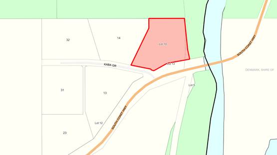
Initially the applicant was seeking approval to use a caravan on site for 4-6 weeks per year, a sea container and a shelter. Following receipt of the application, it came to the attention of Shire Officers that development on the site had already commenced.
Following liaison with Shire Officers, retrospective approval is now being sought to a Relocatable Dwelling, Sea Container, Water Tanks and a Shelter. A copy of the final submitted plans, a photograph of the transportable building and the associated Bushfire Attack Level Assessment are shown attached.
ATTACHMENT: 9.5.6(1)
PUBLIC Consultation Undertaken:
The proposal was referred to the Department of Biodiversity and Attractions for a period of 42 days. No response was received at the time of preparing this agenda item.
COMMENT (Includes Options):
The provisions of Local Planning Scheme No 4 (the Scheme) include the subject land within the Rural-Residential Zone. The intent of the Rural Residential Zone is to “provide for low density residential development in a rural setting consistent and compatible with adjacent land use activity, landscape and the environmental attributes of the land”.
Clause 10.2 of the Scheme prescribes that in determining applications for planning approval, the local government must have regard to various matters. Relevant considerations for the subject application are as follows:
(vii) the content and objective of Planning Precinct Statements set out in Schedule 8 of this Scheme;
(x) the compatibility of a use or development with its setting including the potential impact on the use and enjoyment of adjacent and nearby land and taking into consideration any Special Control Area;
(xiv) whether the land to the application relates is unsuitable for the proposal by reason of it being, or likely to be, subject to flooding, tidal inundation, subsidence, landslip, bush fire or any other risk;
(xv) the preservation of the amenity of the locality; and
(xvi) the relationship of the proposal to development on adjoining land or on other land in the locality including but not limited to, the likely effect of the height, bulk, scale, orientation and appearance of the proposal.
To assist Council in determining the application, the following comments and advice are offered:
Scheme Provisions
The Scheme includes the land within Rural-Residential Area No 20. As outlined in Schedule Two, the following special provisions apply in addition to the general provisions of the Scheme:
1. Subdivision and Development is to be generally in accordance with the Plan of Subdivision which formed part of Amendment 80 to Town Planning Scheme No. 2, or as amended in full or in part by a subsequent Structure Plan endorsed by the local government and the Commission in accordance with Part 6.4 of the Scheme.
2. The provisions of Clause 5.24 regarding supply of water shall apply.
3. In any event no building shall be constructed closer than 100 metres to the boundary of the National Park, except where modified by an endorsed Structure Plan.
4. No stock or domestic animals shall be kept on the land.
5. No boundary fences shall be constructed unless prior approval is granted by the local government in consultation with Department of Parks and Wildlife and Department of Fire and Emergency Services.
6. Owners are required to provide a 50,000 litre water tank solely for fire fighting purposes fitted with standard fire fighting couplings as per Department of Fire and Emergency Services requirements.
7. Where required by the Department of Health and/or local government, alternative treatment units will be installed to the satisfaction of the local government and/or the Department of Health.
8. All new dwellings on the land identified as Lot 10 on Deposited Plan 24178 Kaba Grove, Walpole are to be built in accordance with the provisions for BAL29, or equivalent, as outlined in Australian Standard 3959 Construction of Buildings in Bushfire Prone Areas.
Proposed Transportable Dwelling
The proposed dwelling could be classified as a park home, being located on a chassis with wheels. Provided that the wheels are removed, and the structure is fixed to the ground, the building can be classified as a dwelling. Appropriate conditions of approval are recommended.
Proposed Sea Container
The use of a Shipping Container as proposed complies with the provisions of the Shire’s Local Planning Policy 6.1.3 – Outbuildings.
Proposed Development Location
The special provisions relating to the land require that the development is setback a minimum of 100 metres from the National Park. Whilst the development location achieves this separation from the common boundary with the National Park to the north, a lesser distance is proposed to the eastern side boundary. That said, the building envelope is consistent with the approved subdivision guide plan relating to Rural Residential Area No 20.
Bushfire Management
As reflected at Attachment: 9.5.6(1), the Bushfire Attack Level has been assessed as a BAL-29. Once approved, the landowner will be responsible for establishing and maintaining Asset Protection and Low Fuel Zones as specified by the Shire’s Annual Firebreak Notice and the submitted BAL assessment.
Water Tank
Appropriate water sources are required in terms of both the provision of a potable water supply and for fire fighting purposes. In terms of potable water, clause 5.24 of the Scheme requires that where a dwelling is proposed and connection to a reticulated water service is not available, a rainwater catchment tank with a minimum capacity of 120,000 litres is required.
For the purpose of fire fighting, clause 5.24.3 outlines that the above capacity shall be increased to 135,000 litres. However as outlined above, more specific requirements are identified for Rural Residential Area No 20 with condition 6 of the special provisions requiring the provision of a 50,000 litre water tank solely for fire fighting purposes.
It is recommended that appropriate conditions of approval be imposed to require upgrading the existing water tanks and associated access to comply with the Scheme requirements.
Amenity
The location of the proposed development will result in the development not being visible external to the property. As a result, no requirements relating to painting or otherwise upgrading the relocated dwelling are recommended.
Retrospective Approval
In accordance with clause 8.6 of the Scheme, the local authority may grant approval to a development not withstanding that the development has already commenced. In this case, the development has commenced, but is yet to be completed given the requirement for the dwelling to be permanently fixed to the land and requirements relating to upgrading of the water tank and associated access as identified above.
Conclusion
Provided that the transportable dwelling is fixed to the land in accordance with a building permit, and the water tank is upgraded to comply with scheme requirements, the development will comply with the provisions of Local Planning Scheme No 4. Conditional approval is therefore recommended.
STATUTORY ENVIRONMENT:
Planning and Development Act 2005.
Policy / Strategic Implications:
As stated within the Comment Section above.
Organisational risk management:
Nil.
Financial Implications:
The required retrospective application fee has been paid by the applicant.
Sustainability:
Environmental: Some clearing of existing vegetation will result in order to comply with the Shire of Manjimup’s Annual firebreak notice.
Economic: Nil.
Social: Nil.
VOTING REQUIREMENTS: SIMPLE MAJORITY
|
That Council in accordance with Part 10 of the Shire of Manjimup Local Planning Scheme No.4 grant approval to the proposed transportable dwelling, shipping container, water tanks and freestanding shelter on Lot 10 Kaba Grove, Walpole subject to compliance with the following conditions:
1. The development hereby approved is to be carried out generally in accordance with the plans and specifications submitted with the application, as marked and these shall not be altered and/or modified without the prior knowledge and written consent of the Shire of Manjimup;
2. Prior to the occupation of the dwelling hereby approved, the applicant shall install water tanks for the purposes of providing a potable water supply. In accordance with clause 5.24 of Local Planning Scheme No 4, the tanks shall have a combined capacity of 120,000 litres; 3. In addition to the requirements specified in condition 2 above, a minimum of one water tank shall be established with a minimum capacity of 50,000 litre water tank, solely for firefighting purposes which is to be fitted with standard firefighting couplings as per Department of Fire and Emergency Services requirements and associated accessways; 4. Prior to commencing development, an application to construct or install an apparatus for the treatment of sewage and the disposal of effluent and liquid wastes must be submitted for the approval of the Shire of Manjimup’s Environmental Health Team, in accordance with the Health (Treatment of Sewage and Disposal of Effluent and Liquid Waste) Regulations 1974. 5. The Asset Protection and Low Fuel Zones as required by the submitted BAL assessment and Shire of Manjimup Annual Firebreak Notice shall be implemented and from thereon in maintained; and 6. All buildings are to be constructed in accordance with the Australian Standard 3959 “Construction of Buildings in Bushfire Prone Areas” to the satisfaction of the Shire of Manjimup.
Advice to Applicant: a) The proponent is advised that this development approval is NOT a building permit. A building permit must be formally applied for and obtained from Building Services BEFORE the commencement of any site and/or development works; b) Further to advice note (a) above, the applicant is advised that in order for the transportable development to be considered a dwelling, the wheels are required to be removed and the development is to be fixed to the ground in accordance with the Building Code of Australia; and c) The applicant is advised that the resultant development must comply with all relevant provisions of the Building Code of Australia and the Health (Miscellaneous Provisions) Act 1911 and Shire of Manjimup’s Health Local Laws 2020.
|
|
ATTACHMENTS |
||
|
1⇨ |
Attachment No 1 - Final Site Plan, Photograph of Transportable and Bushfire Attack Level Assessment |
25 Pages |
9.12.1 Proposed Closure and Amalgamation of a Road Reserve Adjoining Lot 9604 Ephraim Gully Grove, Yanmah
|
PROPONENT |
Edward Pocock |
|
OWNER |
Shire of Manjimup |
|
LOCATION / ADDRESS: |
Ephraim Gully Grove, Yanmah |
|
WARD: |
North |
|
ZONE: |
Road Reserve |
|
DIRECTORATE: |
Works & Services |
|
FILE REFERENCE: |
F220196 |
|
LEGISLATION: |
Local Government Act 1995 Land Administration Act 1997 |
|
AUTHOR: |
Yvonne Brown |
|
DATE OF REPORT: |
28 November 2022 |
|
DECLARATION OF INTEREST: |
Nil |
Background:
Council has received a request to close an unnamed and unconstructed road reserve in the vicinity Ephraim Gully Road, Yanmah. The subject road reserve adjoins Lot 9604 Ephraim Gully Grove Yanmah, owned by the proponent, with the intent to amalgamate the closed road reserve into the existing property. In effect, the proposed closure will create a battle-axe lot with road frontage to Ephraim Gully Grove.
Location Plan
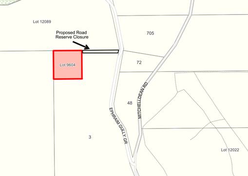
The purpose of this agenda item is to determine Council support for the closure and amalgamation of the unconstructed road reserve and authorisation to initiate a public consultation process in accordance with the Land Administration Act 1997.
PUBLIC Consultation Undertaken:
Nil.
COMMENT (Includes Options):
The current application and proposed closure of the unnamed and unconstructed road reserve does not pose any land lock issues for any adjoining property owners in the area. It is therefore recommended that Council approve the closure of the unconstructed road reserve and subsequent amalgamation into Lot 9604 Ephraim Gully Grove, Yanmah, subject to the outcomes of the public consultation process. The amalgamation process will require the proponent to negotiate with Department of Planning, Lands and Heritage (DPLH) regarding the cost for the purchase of the land.
If supported, in accordance with the Land Administration Act 1997 and the Local Government Act 1995, public notice advertising the proposed closure will be required. Additionally, direct consultation with neighbouring property owners and government agencies will also be undertaken.
Should Council receive no objection to the proposal during the public consultation period, this proposed disposal of road reserve will be forwarded to the DPLH for finalisation. Hence, one of the recommendations to Council indemnifies the Minister for Lands against any claim of compensation resulting from the proposed road closure.
STATUTORY ENVIRONMENT:
To enable the closure of a public road, the Land Administration Act 1997 prescribes a public consultation period followed by a resolution of Council after which, the proposal is submitted to the DPLH.
The Local Government Act 1995 requires public notice for partial or whole road closure.
Policy / Strategic Implications:
Closing and amalgamating the unrequired road reserve serves to reduce the overall land management potential burden on the organisation. The road reserve area to be closed through this proposal is approximately 565m2.
Organisational risk management:
Nil. Prior to Council initiating the road closure process, there is an obligation to ensure that the proposal will not result in land lock issues nor additional cost being imposed by the Shire. Both issues have been negated.
Financial Implications:
Nil. The progression of the road closure is on the basis that the proponent pays all fees and assumes all associated costs including survey fees. The Shire’s fee for the process is $990 and the invoice has been paid by the proponent.
Sustainability:
Environmental: Nil.
Economic: Reducing the number of unconstructed road reserves within the Shire that provide no strategic importance reduces unnecessary land administration activities by the Shire.
Social: Nil.
VOTING REQUIREMENTS: ABSOLUTE MAJORITY
|
That Council: 1. Advise the applicant that it is prepared to support the closure of the unnamed and unconstructed road reserve, Yanmah, subject to no objections received in response to the public consultation period detailed in point 2 below; 2. Approve the undertaking of public consultation process regarding the proposed closure of the unnamed and unconstructed road reserve, Yanmah and subsequent amalgamation into adjacent Lot 9604 Ephraim Gully Grove, Yanmah in accordance with the requirements of the Land Administration Act 1997, for a period of 35 days; 3. Subject to no objections being received in response to the advertising referred to in point 2 above, grant delegated authority to the Chief Executive Officer to forward a request to the Minister of Lands for approval to close the road reserve in accordance with section 58 of the Land Administration Act 1997; 4. Indemnify the Minister for Lands against any claim for compensation resulting from the proposed road closure; and 5. Be provided with a new agenda report should any objection be received as a result of the public consultation.
|
9.12.2 Proposed Award of Tender RFT 03/22 Graphite Road Construction Upgrade
|
PROPONENT |
Shire of Manjimup |
|
OWNER |
Shire of Manjimup |
|
LOCATION / ADDRESS: |
Graphite Road, Manjimup |
|
WARD: |
Central |
|
ZONE: |
Road Reserve |
|
DIRECTORATE: |
Works and Services |
|
FILE REFERENCE: |
F220191 |
|
LEGISLATION: |
Local Government Act 1995 Local Government (Functions and General) Regulations 1996 |
|
AUTHOR: |
Michael Leers |
|
DATE OF REPORT: |
6 December 2022 |
|
DECLARATION OF INTEREST: |
Nil |
Background:
Council’s adopted 2022/23 Infrastructure Works Budget allocates a total of $876,406 for the road re-construction works at Graphite Road SLK 0.5 to 0.8, with contributions from the Shire, Main Roads Western Australia Regional Road Group (RRG) and the Federal Government Roads to Recovery (R2R) Program.
To carry out the road construction works the Shire sought to engage a suitably qualified and experienced contractor. In accordance with the requirements of the Local Government Act 1995, the Request for Tender (RFT) 03/22 Graphite Road Construction Upgrade was advertised seeking the services of road construction companies with experience in construction of Restricted Access Vehicle Network roads. Tenders closed 22 December 2022.
The purpose of this report is to present the results of the Tender assessment for Council’s consideration to award Tender RFT 03/22 Graphite Road Construction Upgrade.
PUBLIC Consultation Undertaken:
Public advertising of the RFT was in the form of an advertisement in the West Australian Newspaper on 19 November 2022, in the Manjimup Bridgetown Times on 23 November 2022 and advertising on the Shire of Manjimup website from 9 November 2022 with the request for tender process closing 22 December 2022.
COMMENT (Includes Options):
Ten (10) prospective tenderers downloaded documents from the Shire’s website with a total of four (4) Tenders received by the specified closing time.
A Tender Evaluation Panel, comprising three members, undertook to independently assess the Tenders received using an assessment matrix. The assessment scores were then averaged. The spreadsheet is attached.
ATTACHMENT: 9.12.2(1)
A summary of the evaluation is presented in the table below. The matrix referenced the terms and assessment criteria of the RFT document. In particular are the criteria for experience and ability to deliver road construction works to a sealed Restricted Access Vehicle Network road standard.
|
|
Weighted Score |
||||
|
(a) Experience |
(b) Ability to Deliver |
(c) Price |
Total Score |
Ranking |
|
|
Carbone Bros. Pty Ltd |
19.2 |
16.7 |
27.2 |
63.1 |
1 |
|
Castle Civil |
17.5 |
15 |
25.5 |
58.0 |
3 |
|
West Coast Profilers Civil Ltd |
18.3 |
17.5 |
22.3 |
58.1 |
2 |
Three of the four Tenders received were generally of a suitable standard. However, one Tender was not complete and considered non-compliant. The Griffin Civil Tender was not assessed due to the fact that Part 5 of the RFT was not returned despite being clearly requested at the top of the page. Part 5 of the RFT is a critical component of the RFT as it is the Tenderers Offer, which includes:
· The Tenderers acknowledgement that they will comply with the RFT schedules and appendices;
· The Tenderers acknowledgement of their intended use of subcontractors, whether they are agents or trustees of other parties and acknowledgement of any conflicts of interest; and
· Acknowledgement that all parts of the RFT have been included.
The Tendered prices ranged from $990,766 to $1,403,812 with all Tendered prices being greater than the Council adopted budget allocated for the road construction upgrade works.
Based on all of the information received and assessed it is recommended by the Panel to award Tender RFT 03/22 Graphite Road Construction Upgrade to Carbone Brothers Pty Ltd. Council is also requested to approve the 2022/23 Infrastructure Works Budget accordingly.
Applications for RRG funding are submitted one to two years in advance of project works commencing. This does not always allow for unforeseen economic pressures such as the significant rise in construction cost currently being experienced in the south west. Normally the Shire is able to adapt the construction program or scope of works enabling works to be completed within budget. The construction of Graphite Road SLK 0.5 to 0.8 is that section between Ward Street and Collier Street is arguably the most degraded section of Graphite Road. The major issue with this section of road is the poor and failing drainage. As a result of the complexity of works at this section of road, such as drainage renewal, the Shire is unable to reduce the scope of works to a practical specification. Incidentally, it’s drainage that has seen some of the most significant increase in costs.
The Shire seeks Council’s approval for an amendment to Council’s Infrastructure Works Budget 2022/23 of $120,000 for Drainage – Various Manjimup Priority 1 in order to meet the budget shortfall. Given that works have yet to commence on the Drainage – Various Manjimup Priority 1 works, alongside the fact that much of the issue with Graphite Road SLK 0.5 to 0.8 failing is due to drainage issues, it seems an appropriate budget amendment.
STATUTORY ENVIRONMENT:
The Local Government Act 1995 and Local Government (Functions and General) Regulations 1996 require Tenders to be publicly invited for contracts exceeding $250,000 in value.
Policy / Strategic Implications:
The re-construction works are supported in the Main Roads Draft 2040 Regional Strategies for Significant Local Government Roads. Further road improvement is featured heavily in the Council’s Strategic Community Plan.
Organisational risk management:
Risk mitigation has been achieved by the following;
· An assessment panel consisting of three (3) members have all independently completed a Tender Assessment Matrix and summarised their findings.
· Reference checks previously undertaken and previous works being carried out for the Shire.
· Demonstrated financial sustainability.
Financial Implications:
There are no negative financial implications for the Shire amending the Infrastructure Works Budget 2022/23. The $120,000 from Drainage – Manjimup Priority 1 will be used directly on renewing and upgrading the travel surface and drainage on one of Manjimup’s most significant roads.
Sustainability:
Environmental: Nil.
Economic: The new pavement and road surface will significantly improve the aesthetics and physical condition of the road assisting residential and commercial activities.
Social: Safe and suitable roads support thriving communities.
VOTING REQUIREMENTS: ABSOLUTE MAJORITY
|
That Council; 1. Award Tender RFT 03/22 Graphite Road Construction Upgrade to Carbone Brothers Pty Ltd for a price of $990,766 (ex GST.); and 2. Approve the budget amendment of $120,000 from “Drainage – Manjimup Priority 1” to “Roads – Graphite Road SLK 0.5 to 0.8 c/f” in accordance with the table below.
|
|
ATTACHMENTS |
||
|
1⇨ |
Averaged Scores of Evaluation Sheet RFT 03-22 Graphite Rd Construction Upgrade Contract |
1 Page |
9.15.1 Unconfirmed Minutes of the Audit Committee Meeting Held 29 November 2022
|
PROPONENT |
Shire of Manjimup |
|
OWNER |
N/A |
|
LOCATION / ADDRESS: |
Whole of Shire |
|
WARD: |
All |
|
ZONE: |
N/A |
|
DIRECTORATE: |
Business |
|
FILE REFERENCE: |
F170379 |
|
LEGISLATION: |
Local Government Act 1995, Local Government (Financial Management) Regulations 1996 |
|
AUTHOR: |
Greg Lockwood |
|
DATE OF REPORT: |
1 December 2022 |
|
DECLARATION OF INTEREST: |
Nil |
Background:
On the 29 November 2022 Council’s Audit Committee met with the purpose of:
1) Receiving the unconfirmed minutes of the Audit Committee held 17 November 2022; and
2) Receiving the Shire of Manjimup 2022 Annual Financial Report findings from the Office of Auditor General.
The purpose of this agenda item is to receive the unconfirmed minutes of the Audit Committee meeting held on 29 November 2022.
ATTACHMENT: 9.15.1(1)
PUBLIC Consultation Undertaken:
Nil.
COMMENT (Includes Options):
The main purpose of the Audit Committee meeting held 29 November 2022 was to receive a presentation via Microsoft Teams from Franca Ciminata from the Office of Auditor General (OAG), supported by James Arthur and Chai Wen-Shien from Moore Australia, on the outcome of the Shire of Manjimup’s 2022 Annual Financial audit.
Moore Australia talked the Audit Committee through the process to undertake a Local Government Audit as well as advising that there was only one item requiring action, being the revaluation of Infrastructure Assets. The OAG felt that the Infrastructure Revaluation scheduled for 2023, perhaps should have been brought forward considering price changes and material and contractor supply issues in 2022, possibly understating the value of the asset class.
STATUTORY ENVIRONMENT:
Local Government Act 1995 and Local Government (Financial Management) Regulations 1996
Policy / Strategic Implications:
The Audit Committee is established under the Local Government Act 1995 to provide guidance and assistance to the Local Government in achieving the audit requirements of the Act thus ensuring that the financial management of the Shire of Manjimup remains open, transparent and accountable.
Organisational risk management:
Nil.
Financial Implications:
Nil.
Sustainability:
Environmental: Nil.
Economic: It is essential that Local Government maintains open, transparent and accountable processes in the expenditure of public monies. Regular financial audits by auditors and the functions of the Audit Committee are some of the methods established to assist Local Government in meeting legislative and community expectations.
Social: Nil.
VOTING REQUIREMENTS: SIMPLE MAJORITY
|
That Council: 1. Receive the unconfirmed minutes of the Audit Committee meeting held 29 November 2022 as per Attachment: 9.15.1(1); and 2. Accept the findings from the 2022 Annual Financial Report. |
|
ATTACHMENTS |
||
|
1⇨ |
Aduit Committee Meeting Minutes - 29 November 2022 |
8 Pages |
APPENDIX
9.15.2 Unconfirmed Minutes of the Northcliffe Town Hall Management Committee held on 7 November 2022
|
PROPONENT |
Northcliffe Town Hall Management Committee |
|
OWNER |
Shire of Manjimup |
|
LOCATION / ADDRESS: |
Northcliffe Town Hall – 54-58 Zamia Street, Northcliffe |
|
WARD: |
Coastal |
|
ZONE: |
Public Purposes |
|
DIRECTORATE: |
Development and Regulation |
|
FILE REFERENCE: |
F170371 |
|
LEGISLATION: |
Local Government Act 1995 |
|
AUTHOR: |
Robyn Filipiak/Brian Robinson |
|
DATE OF REPORT: |
6 January 2023 |
|
DECLARATION OF INTEREST: |
Nil |
Background:
The Northcliffe Town Hall Management Committee is a Management Committee appointed by Council under the Local Government Act 1995 to assist the Shire in the management of the Northcliffe Town Hall (the Town Hall) with the following functions in accordance with the Terms of Reference:
1. Provide responsible management for the Northcliffe Town Hall.
2. Prepare a budget for consideration by Council.
3. Recommend fees and charges for adoption by Council.
4. Expend funds in accordance with the approved budget and in consultation with relevant manager.
5. Prepare an appropriate development plan in consultation with relevant Shire departments for Council consideration.
A copy of the current Terms of Reference are appended.
APPENDIX: 9.15.2(A)
The purpose of this item is to present for Council’s information and consideration, the Committee’s unconfirmed minutes for the meeting held on 7 November 2022.
In addition to considering the unconfirmed minutes, Council is requested to consider several modifications to the Terms of Reference as outlined in the comment section below and reflected within the attached draft Terms of Reference.
ATTACHMENT: 9.15.2(2)
PUBLIC Consultation Undertaken:
Nil.
COMMENT (Includes Options):
As reflected within the unconfirmed minutes shown at Attachment: 9.15.2(1), the committee pass two resolutions, one of which requires a decision of Council. The following is a summary of the resolutions passed:
|
Committee Resolution |
Officer Recommendation |
|
|
1. |
That the minutes of the Northcliffe Town Hall Management Committee Meeting held on 22 August 2022 meeting be confirmed as a true and accurate record of the meeting. |
The resolution be noted. |
|
2. |
That Jenny Smith be appointed as a Community Representative as per the Northcliffe Town Hall Management Committee’s Terms of Reference.
|
The committee recommendation be supported, and the Terms of Reference be amended accordingly. |
In addition to including Ms Smith as a Community Representative, the following two additional changes are recommended to the committee structure:
a) Removal of Youth Representative – Rylee Bennett as their family has moved from the district and they are no longer participating in the committee; and
b) Modification of the Shire Officer representation as Mr Jamie Jones no longer works for the Shire. As a result, the Shires Manager of Building Services has been acting as Shire Representative. The Shire’s Building Officer – Ethan Stokes to be the new proxy.
Council is requested to adopt the new Terms of Reference (shown at Attachment: 9.15.2 (2)), which have been modified to reflect the above changes.
STATUTORY ENVIRONMENT:
As a Management Committee, the operation of the Northcliffe Town Hall Management Committee is required to comply with the Local Government Act 1995.
Policy / Strategic Implications:
Ongoing management of the Northcliffe Town Hall and recognition of contributions made by the community are consistent with the following strategies within the Shire of Manjimup Strategic Community Plan (2021-2031):
Strategy C2 – Support volunteer community groups, encourage participation (particularly in the areas of emergency management) and acknowledge contributions.
Strategy D5 – Develop and maintain community infrastructure to a service level that meets the community’s needs.
Organisational risk management:
Nil.
Financial Implications:
Nil.
Sustainability:
Environmental: Nil.
Economic: Nil.
Social: Nil.
VOTING REQUIREMENTS: ABSOLUTE MAJORITY
|
That Council: 1. Receive the Unconfirmed Minutes of the Northcliffe Town Hall Management Committee held on 7 November 2022 as shown in Attachment: 9.15.2(1); and
2. Adopt the revised Terms of Reference for the Northcliffe Town Hall Management Committee as shown Attachment: 9.15.2(2), in order to reflect the following changes: a) Removal of Rylee Bennett as Youth Representative; b) Nomination of Ms Jenny Smith as Community Representative; c) Removal of Mr Jamie Jones as Shire Representative; d) Inclusion of Mr Peter Krispyn – Manager of Building Services as Shire Representative; and e) Inclusion of Mr Ethan Stokes as Proxy Shire Representative.
|
|
ATTACHMENTS |
||
|
1⇨ |
Attachment No 1 - Unconfirmed Minutes for meeting held on 7 November 2022 |
4 Pages |
|
2⇨ |
Attachment No 2 - Draft Terms of Reference |
1 Page |
|
APPENDICES |
||
|
a⇨ |
Appendix A - Current Terms of Reference |
1 Page |
9.16.1 Informal Meeting Notes of the Pemberton Town Activation Advisory Committee Meeting Held 30 November 2022
|
PROPONENT |
Shire of Manjimup |
|
OWNER |
Shire of Manjimup |
|
LOCATION / ADDRESS: |
Pemberton |
|
WARD: |
West |
|
ZONE: |
NA |
|
DIRECTORATE: |
Works and Services |
|
FILE REFERENCE: |
F170456 |
|
LEGISLATION: |
Local Government Act 1995 |
|
AUTHOR: |
Michael Leers |
|
DATE OF REPORT: |
7 December 2022 |
|
DECLARATION OF INTEREST: |
Nil |
Background:
The Pemberton Town Activation Advisory Committee is an Advisory Committee of Council, formed in accordance with Part 5 of the Local Government Act 1995. The functions of the committee are:
· Identification of opportunities for space activation within the main street or adjacent open space;
· Liaison with other relevant community groups and / or service agencies over potential art or cultural projects; and
· Assisting Shire of Manjimup Officers in drafting design guidelines to guide future developments within the Town Centre precinct.
The purpose of this report is to accept the informal meeting notes of the Pemberton Town Activation Committee meeting held on 30 November 2022. A copy of the minutes is attached.
ATTACHMENT: 9.16.1 (1)
PUBLIC Consultation Undertaken:
Nil.
COMMENT (Includes Options):
As the Committee did not achieve a quorum of six (6) as noted on the Terms of Reference, there are no recommendations to present to Council.
STATUTORY ENVIRONMENT:
Local Government Act 1995
Policy / Strategic Implications:
Revitalisation of the Pemberton Town Centre will ensure that the town is accessible, attractive and inviting, whilst maintaining its unique character, consistent with Community Goal 4.4 as identified in the Shire’s Strategic Community Plan.
Organisational risk management:
Nil.
Financial Implications:
Nil.
Sustainability:
Environmental: The Committee aims to assist the Shire guide future developments in the town.
Economic: By addressing opportunities for space activation within the town centre, local businesses will benefit.
Social: The Terms of Reference for this committee pay particular attention to encouraging a cohesive social fabric.
VOTING REQUIREMENTS: SIMPLE MAJORITY
|
That Council receive the informal notes of the Pemberton Town Activation Advisory Committee meeting held 30 November 2022, as shown at Attachment 9.16.1 (1).
|
|
ATTACHMENTS |
||
|
1⇨ |
Informal Meeting Pemberton TAAC Meeting Minutes 30 November 2022 |
2 Pages |
9.16.2 Unconfirmed Minutes of the Manjimup Rea Park and Collier Street Redevelopment Advisory Committee Meeting held 6 December 2022
|
PROPONENT |
Shire of Manjimup |
|
OWNER |
Shire of Manjimup |
|
LOCATION / ADDRESS: |
Manjimup |
|
WARD: |
Central |
|
ZONE: |
Parks and Recreation |
|
DIRECTORATE: |
Community Services |
|
FILE REFERENCE: |
F210096 |
|
LEGISLATION: |
Local Government Act 1995 |
|
AUTHOR: |
Shammara Markotis |
|
DATE OF REPORT: |
13 December 2022 |
|
DECLARATION OF INTEREST: |
Nil |
Background:
The Manjimup Rea Park and Collier Street Redevelopment (MRCR) Advisory Committee is an Advisory Committee of Council, formed in accordance with Part 5 of the Local Government Act 1995.
The purpose of the Committee is:
· “To provide advice to Council on the Manjimup Rea Park & Collier Street Redevelopment Project for the duration of the Project, including the Planning & Design and Construction & Implementation stages;
· To make recommendations to Council in regard to matters that will improve the planning, design, construction, and future use and sustainability of the sport and recreation facilities at the Rea Park & Collier Street Precinct for the benefit of the broader community;
· To provide input into and feedback on design, research sport specific needs, and contribute to ideas for the Project;
· To provide advice on trends in sport and recreation (e.g. participation rates, regulations, facilities) where relevant to the Project;
· Representative Members acknowledge and accept their role as a representative of their sport (rather than a particular club) and to act as a key liaison for that sport; and
· Communicate and inform represented groups and the local community regarding activities of the Committee”.
The purpose of this report is to present the unconfirmed minutes of the MRCR Advisory Committee meeting held on 6 December 2022, as attached, for Council consideration.
ATTACHMENT: 9.16.2 (1)
PUBLIC Consultation Undertaken:
Nil.
COMMENT (Includes Options):
There are no recommendations made by the MRCR Advisory Committee requiring a Council decision.
STATUTORY ENVIRONMENT:
Local Government Act 1995.
Policy / Strategic Implications:
Shire of Manjimup Strategic Community Plan 2021-2031:
- Strategy C1 - Encourage co-locations, partnerships and resource sharing to deliver community services.
- Strategy C18 - Create, support and promote a broad range of sporting, recreational and social opportunities that are accessible and inclusive for all ages and abilities.
- Strategy D5 - Develop and maintain community infrastructure to a service-level that meets the community’s needs.
- Strategy D12 - Assist communities to build and maintain sport and recreation facilities whilst encouraging co-locations, collaborations and resource sharing wherever possible.
Strategy D13 - Support the development of a state-level sporting facility in the township of Manjimup.
Organisational risk management:
Nil.
Financial Implications:
Nil.
Sustainability:
Environmental: Nil.
Economic: Nil.
Social: Collaboration between sporting clubs and community members is important in the sustainable development of community sport and recreation facilities.
VOTING REQUIREMENTS: SIMPLE MAJORITY
|
That Council receive the unconfirmed meeting minutes of the Manjimup Rea Park and Collier Street Redevelopment Advisory Committee meeting held 6 December 2022 as per Attachment: 9.16.2(1). |
|
ATTACHMENTS |
||
|
1⇨ |
Unconfirmed Minutes of the Manjimup Rea Park and Collier Street Redevelopment Advisory Committee Meeting held 6 December 2022 |
4 Pages |
9.16.3 Unconfirmed Minutes of the Bush Fire Advisory Committee (BFAC) Meeting held 7 December 2022
|
PROPONENT |
Shire of Manjimup |
|
OWNER |
Shire of Manjimup |
|
LOCATION / ADDRESS: |
Whole of Shire |
|
WARD: |
All |
|
ZONE: |
All |
|
DIRECTORATE: |
Development and Regulation |
|
FILE REFERENCE: |
F170451 |
|
LEGISLATION: |
Local Government Act 1995 Bush Fires Act 1954 |
|
AUTHOR: |
Nicole Favero |
|
DATE OF REPORT: |
20 December 2022 |
|
DECLARATION OF INTEREST: |
Nil |
Background:
The purpose of the Bush Fire Advisory Committee is to represent Volunteer Bush Fire Brigades within the Shire and to make recommendations to Council on various matters relating to bushfire, including, but not limited to budgets, management of the Bushfire organisations and implementation of Council’s Fire Protection Strategy.
This report presents the unconfirmed minutes of the Bush Fire Advisory Committee (BFAC) meeting held on the 7 December 2022 including relevant attachments. A copy of the unconfirmed minutes are attached.
ATTACHMENT: 9.16.3(1)
PUBLIC Consultation Undertaken:
Nil.
COMMENT (Includes Options):
The Bush Fire Advisory Committee resolved to support two recommendations, one of which require a formal decision of Council. The resolutions passed at the meeting are detailed below:
|
Bush Fire Advisory Committee Resolutions |
Officers Comments |
|
That the unconfirmed minutes of the General Meeting held Wednesday 7 December 2022 be received as a true and correct record. |
The BFAC resolution is supported. |
|
Recommendation that Administration proceed to advertising for the Amalgamation of remaining Northcliffe Brigades. |
The BFAC resolution is supported. No action required by Council. Administration to proceed to advertise. |
STATUTORY ENVIRONMENT:
Bush Fires Act 1954 and Local Government Act 1995.
Policy / Strategic Implications:
Nil.
Organisational risk management:
Nil.
Financial Implications:
Nil.
Sustainability:
Environmental: Nil.
Economic: Nil.
Social: Nil.
VOTING REQUIREMENTS: SIMPLE MAJORITY
|
That Council receive and note the unconfirmed minutes of the Bush Fire Advisory Committee (BFAC) meeting held 7 December 2022 as shown in Attachment: 9.16.3(1).
|
|
ATTACHMENTS |
||
|
1⇨ |
Unconfirmed Minutes of the Bush Fire Advisory Committee (BFAC) Meeting held 7 December 2022 |
16 Pages |
9.16.4 Unconfirmed Minutes of the Local Emergency Management Committee (LEMC) Meeting held 30 November 2022
|
PROPONENT |
Shire of Manjimup |
|
OWNER |
Shire of Manjimup |
|
LOCATION / ADDRESS: |
Whole of Shire |
|
WARD: |
All |
|
ZONE: |
All |
|
DIRECTORATE: |
Development and Regulation |
|
FILE REFERENCE: |
F170449 |
|
LEGISLATION: |
Emergency Management Act 2005, Local Government Act 1995 |
|
AUTHOR: |
Nicole Favero |
|
DATE OF REPORT: |
20 December 2022 |
|
DECLARATION OF INTEREST: |
Nil |
Background:
The Local Emergency Management Committee is an Advisory Committee of Council, formed in accordance with Part 5 of the Local Government Act 1995. As stated within the Terms of Reference, the purpose of the committee is, in accordance with Section 39 of the Emergency Management Act 2005:
a) To advise and assist the Council in ensuring that local emergency arrangements are established;
b) To liaise with public authorities and other persons in the development, review and testing of Local Emergency Management Arrangements; and
c) To carry out other emergency management activities as directed by the State Emergency Management Committee or prescribed by regulations.
The unconfirmed minutes of the latest Local Emergency Management Committee (LEMC) meeting held on the 30 November 2022 are attached for Council consideration.
ATTACHMENT: 9.16.4 (1)
PUBLIC Consultation Undertaken:
Nil.
COMMENT (Includes Options):
As reflected within the unconfirmed minutes, the committee was briefed on several matters relating to recent incidents in the South West and resolved to pass the following two resolutions:
|
That the unconfirmed minutes of the General Meeting held Wednesday 21 September 2022 be received as a true and correct record. |
The LEMC resolution is supported. |
|
That Council confirm and accept the amendments to Appointments of the Local Emergency Management Committee Terms of Reference for the two year period that commenced on 21 October 2021. |
The LEMC resolution is supported. A separate item is prepared for Council. |
As reflected above, a separate agenda item has been included within this agenda for the proposed amendments to the Terms of Reference for the Local Emergency Management Committee.
STATUTORY ENVIRONMENT:
Emergency Management Act 2005 and Local Government Act 1995.
Policy / Strategic Implications:
The operation of the Local Emergency Management Committee is consistent with the Shire of Manjimup Strategic Community Plan 2019-2029, with specific reference to the following Community Goals and associated Strategies:
Community Goals
3.3 Our whole community participates in strategies to ensure we are minimising risks in regards to bushfire and other natural emergencies.
3.5 Residents feel safe, secure and comfortable at home, work and at play.
Strategies
C22 Prepare for emergencies and natural disasters.
Organisational risk management:
By participating in the LEMC, Shire Officers are seeking to minimise risks to the Shire, its residents and assets associated with local level emergencies.
Financial Implications:
Nil.
Sustainability:
Environmental: Nil.
Economic: Nil.
Social: Nil.
VOTING REQUIREMENTS: SIMPLE MAJORITY
|
That Council receive and note the unconfirmed Minutes of the Local Emergency Management Committee (LEMC) Meeting held on the 30 November 2022 as shown in Attachment: 9.16.4(1). |
|
ATTACHMENTS |
||
|
1⇨ |
Unconfirmed Minutes of the Local Emergency Management Committee (LEMC) Meeting held 30 November 2022 |
13 Pages |
APPENDIX
9.16.5 Proposed Amendments to the Local Emergency Management Committee Terms of Reference
|
PROPONENT |
Shire of Manjimup |
|
OWNER |
Shire of Manjimup |
|
LOCATION / ADDRESS: |
Whole of Shire |
|
WARD: |
All |
|
ZONE: |
All |
|
DIRECTORATE: |
Development and Regulation |
|
FILE REFERENCE: |
F170496 |
|
LEGISLATION: |
Emergency Management Act 2005 and Local Government Act 1995 |
|
AUTHOR: |
Todd Ridley |
|
DATE OF REPORT: |
4 January 2023 |
|
DECLARATION OF INTEREST: |
Nil |
Background:
The Local Emergency Management Committee (LEMC) is required to be formed under clause 38 of the Emergency Management Act 2005 with the following functions in accordance with clause 39 of that Act:
a) To advise and assist Council in ensuring that local emergency arrangements are established;
b) To liaise with public authorities and other persons in the development, review and testing of local emergency management arrangements; and
c) To carry out other emergency management activities as directed by the SEMC or prescribed by regulations.
Membership of LEMC consists mainly of Emergency Management staff and volunteers from the Shire of Manjimup and Departments or Agencies that may have a role in emergency management throughout the Shire of Manjimup.
The appointment of elected members to the committee, conduct of the committee including frequency of meetings and delegations are reflected within the Terms of Reference adopted under the Local Government Act 1995. The current Terms of Reference for LEMC can be found in the attached Appendix.
APPENDIX: 9.16.5 (A)
Council is requested to consider modification of the current Terms of Reference to adjust the composition of the committee and frequency of meetings in accordance with a resolution of LEMC at its 30 November 2022 meeting. A copy of the new draft Terms of Reference is shown attached.
ATTACHMENT: 9.16.5 (1)
PUBLIC Consultation Undertaken:
Nil.
COMMENT (Includes Options):
As reflected at Item 9.16.4 of this agenda, LEMC reviewed its Terms of Reference at its meeting held on the 30 November 2022 and recommended “That Council confirm and accept the amendments to the Local Emergency Management Committee Terms of Reference for the two year period that commenced on 21 October 2021”. The following is a summary of the recommended modifications:
a) Amended Member and Proxy positions attached to relevant State Government Departments and Agencies that reflect:
· Reflect changes in the Warren Health Services, with the restructure of management of the Manjimup and Pemberton hospitals;
· District Emergency Management Committee and Western Power members have been moved from Voting to Non-Voting members; and
· St John Ambulance Walpole Service and Water Corporation being identified as Non-Voting Representatives.
b) The addition of the Shire of Manjimup’s Recovery Coordinator as a non-voting member;
c) The reduction of the number of meetings four to three times per year. The proposed meeting schedule being consistent with the Bush Fire Advisory Committee, being a pre and post bushfire season and winter / storm meeting; and
d) The adjustment of the Delegated Power with the addition of the Local Government Act 1995 and the Officer Responsible from the Chief Executive Officer to the Community Emergency Services Manager, consistent with Bush Fire Advisory Committee Terms of Reference. This delegation relates to the administration of the Committee, but does not extend to actions associated with responses to emergency events as they may arise.
As reflected in the proposed LEMC Terms of Reference voting membership has been reduced from fifteen to fourteen, however there is a proposed addition of 5 Non-Voting Representatives.
STATUTORY ENVIRONMENT:
The LEMC is established in accordance with Emergency Management Act 2005 and governed by the Local Government Act 1995 as a Committee of Council.
Policy / Strategic Implications:
The operation of the Local Emergency Management Committee is consistent with the Shire of Manjimup Strategic Community Plan 2021-2031, with specific reference to the following Community Goals and associated Strategies:
Community Goals
3.3 Our whole community participates in strategies to ensure we are minimising risks in regards to bushfire and other natural emergencies.
3.5 Residents feel safe, secure and comfortable at home, work and at play.
Strategies
C22 Prepare for emergencies and natural disasters.
Organisational risk management:
By participating in the LEMC, Shire Officers aim to minimise risks to the Shire, its residents and assets associated with local level emergencies.
Financial Implications:
Nil.
Sustainability:
Environmental: Nil.
Economic: Nil.
Social: Nil.
VOTING REQUIREMENTS: ABSOLUTE MAJORITY
|
That Council confirm and accept the amended Terms of Reference for the Local Emergency Management Committee as shown at Attachment: 9.16.5.(1).
|
|
ATTACHMENTS |
||
|
1⇨ |
Proposed Local Emergency Management Committee Terms of Reference 2021 - 2023 |
2 Pages |
|
APPENDICES |
||
|
a⇨ |
Current Local Emergency Management Committee - Terms of Reference 2021 - 2023 |
2 Pages |
10. LATE REPORTS:
11. QUESTIONS FROM MEMBERS:
11.1 Response to questions from members taken on notice.
11.2 Questions from members.
12. MOTIONS FOR CONSIDERATION AT THE FOLLOWING MEETING:
13. NEW BUSINESS OF AN URGENT NATURE INTRODUCED BY DECISION OF THE MEETING:
14. APPLICATIONS FOR LEAVE OF ABSENCE:
15. CLOSURE:
In closing I acknowledge the contributions of pioneers and group settlers who opened up this land and through their efforts allow us to enjoy the lifestyle we live today.
There being no further business to discuss the Shire President to thank those in attendance and close the meeting at…………pm.